Sultan Dam

Last updated
Sultan Mahmud Dam
Band-e Sultan in Jaghatu, Wardak.jpg
Band-e Sultan in Jaghatu
Location Ghazni Province, Afghanistan
Construction began10th century
Dam and spillways
Impounds Ghazni River
Location of the Ghazni Province of Afghanistan Afghanistan-Ghazni.png
Location of the Ghazni Province of Afghanistan

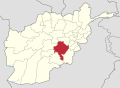
The Sultan Mahmud Dam or Band-e Sultan is a dam located on the Ghazni River in the Jaghatu District of Ghazni Province in Afghanistan. [1] [2] As of April 2013, the dam is just used for irrigating 15,000 hectares of land. It is believed to have the potential to meet electricity needs of 50,000 families. The dam has importance for residents of Ghazni and neighboring Maidan Wardak province. It is believed to be first built during the Ghaznavids era in the 10th century, in memory of Sultan Mahmud of Ghazni. [3]

Contents

The barrage collapsed in March 2005, leading to catastrophic flooding of the city of Ghazni, 30 km away. [4] [5]

See also

Related Research Articles

<span class="mw-page-title-main">Economy of Afghanistan</span>

The economy of Afghanistan is listed as the 124th largest in the world in terms of nominal gross domestic product (GDP), and 102nd largest in the world in terms of purchasing power parity (PPP). With a population of around 41 million people, Afghanistan's GDP (nominal) stands at $14.58 billion as of 2021, amounting to a GDP per capita of $363.7. Its annual exports exceed $2 billion, with agricultural, mineral and textile products accounting for 94% of total exports. The nation's total external debt is $1.4 billion as of 2022.

<span class="mw-page-title-main">Herat</span> City in Herat Province, Afghanistan

Herāt is an oasis city and the third-largest city in Afghanistan. In 2020, it had an estimated population of 574,276, and serves as the capital of Herat Province, situated south of the Paropamisus Mountains in the fertile valley of the Hari River in the western part of the country. An ancient civilization on the Silk Road between West, Central and South Asia, it serves as a regional hub in the country's west.

<span class="mw-page-title-main">Ghazni</span> City in Ghazni Province, Afghanistan

Ghazni, historically known as Ghaznain (غزنين) or Ghazna (غزنه), also transliterated as Ghuznee, and anciently known as Alexandria in Opiana, is a city in southeastern Afghanistan with a population of around 190,000 people. The city is strategically located along Highway 1, which has served as the main road between Kabul and Kandahar for thousands of years. Situated on a plateau at 2,219 metres (7,280 ft) above sea level, the city is 150 kilometres (93 mi) south of Kabul and is the capital of Ghazni Province. The name Ghazni drives from the Persian word "ganj", meaning ‘treasure’.

<span class="mw-page-title-main">Ghazni Province</span> Province of Afghanistan

Ghazni is one of the 34 provinces of Afghanistan, located in southeastern Afghanistan. The province contains 19 districts, encompassing over a thousand villages and roughly 1.3 million people, making it the 5th most populous province. The city of Ghazni serves as the capital. It lies on the important Kabul–Kandahar Highway, and has historically functioned as an important trade center. The Ghazni Airport is located next to the city of Ghazni and provides limited domestic flights to Afghanistan's capital, Kabul.

<span class="mw-page-title-main">Ghor Province</span> Province of Afghanistan

Ghōr also spelled Ghowr or Ghur is one of the thirty-four provinces of Afghanistan. It is located in the western Hindu Kush in central Afghanistan, towards the northwest. The province contains eleven districts, encompassing hundreds of villages, and approximately 764,472 settled people. Firuzkoh is the capital of the province.

The Kabul–Kandahar Highway (NH0101) is 483-kilometer (300 mi) long that links Afghanistan's two largest cities, Kabul and Kandahar. It starts from Dashte Barchi in Kabul and passes through Maidan Shar, Saydabad, Ghazni, and Qalat until it reaches Aino Mina in Kandahar. It is currently being rehabilitated at different locations. This highway is a key portion of Afghanistan's national highway system or "National Highway 1". The entire highway between Kabul and Kandahar has no mountain passes but there are many mountains nearby in some places. Approximately 35 percent of Afghanistan's population lives within 50 km (31 mi) of the Kabul to Kandahar portion of the Afghanistan Ring Road.

<span class="mw-page-title-main">Ghaznavids</span> Medieval Muslim Turkic dynasty and state

The Ghaznavid dynasty or the Ghaznavid Empire was a Persianate Muslim dynasty and empire of Turkic mamluk origin, ruling at its greatest extent, large parts of Iran, Khorasan, and the northwest Indian subcontinent from 977 to 1186. The dynasty was founded by Sabuktigin upon his succession to the rule of Ghazna after the death of his father-in-law, Alp Tigin, who was an ex-general of the Samanid Empire from Balkh.

<span class="mw-page-title-main">Mahmud of Ghazni</span> Sultan of the Ghaznavid Empire from 998 to 1030

Abu al-Qasim Mahmud ibn Sabuktigin, usually known as Mahmud of Ghazni or Mahmud Ghaznavi, was Sultan of the Ghaznavid Empire, ruling from 998 to 1030. During his reign and in medieval sources, he is usually known by his honorific Yamin al-Dawla. At the time of his death, his kingdom had been transformed into an extensive military empire, which extended from northwestern Iran proper to the Punjab in the Indian subcontinent, Khwarazm in Transoxiana, and Makran.

<span class="mw-page-title-main">Minaret of Jam</span> Minaret in Ghor Province, Afghanistan

The Minaret of Jam is a UNESCO World Heritage Site in western Afghanistan. It is located in a remote and nearly inaccessible region of the Shahrak District, Ghor Province, next to the Hari River. The 62 m (203 ft) or 65 m (213 ft) high minaret was built c. 1190 entirely of baked bricks and is famous for its intricate brick, stucco and glazed tile decoration, which consists of alternating bands of kufic and naskhi calligraphy, geometric patterns, and verses from the Qur'an. Since 2002, the minaret has remained on the list of World Heritage in Danger, under serious threat of erosion, and has not been actively preserved. In 2014, the BBC reported that the tower was in imminent danger of collapse.

<span class="mw-page-title-main">Environmental issues in Afghanistan</span>

Environmental issues in Afghanistan are monitored by the National Environmental Protection Agency (NEPA). They predate the political turmoil of the past few decades. Forests have been depleted by centuries of grazing and farming, practices which have only increased with modern population growth.

<span class="mw-page-title-main">Nawur District</span> District in Ghazni, Afghanistan

Nawur is one of the districts of Afghanistan, which is located in the northern part of Ghazni Province. With an area of approximately 5,234 km2 (2,021 sq mi), Nawur is the largest district of Ghazni province. Its population was estimated at 91,778 in 2002. Nawur's inhabitants are ethnic Hazaras followed by Kochis. The Jikhai River originates here.

Miray (Miri) is the district center of Andar District, Ghazni Province, Afghanistan. It is located at 33.3225°N 68.4425°E at 2,069 m altitude.

The Jikhai River is a river in Ghazni Province, central Afghanistan, originating in Nawur District and crossing the Ajristan valley. It is the only source of water available to the small number of inhabitants as the area is affected by a severe drought. Dams on the river have a history of breaking and causing severe damage and death.

<span class="mw-page-title-main">Tourism in Afghanistan</span>

Tourism in Afghanistan is regulated by the Ministry of Information and Culture. There are at least 350 tourism companies operating in Afghanistan. Tourism was at its peak before the 1978 Saur Revolution, which was followed by the decades of war. Between 2013 and 2016, Afghan embassies issued between 15,000 and 20,000 tourist visas annually.

<span class="mw-page-title-main">Sarda Dam</span> Dam in Ghazni, Afghanistan

The Sarda Dam is located near the town of Sardeh Band, in the eastern part of Andar District of Ghazni Province of Afghanistan. Part of its reservoir, which provides fresh water to much of southern Ghazni, is in neighboring Paktika Province. In recent years, the locals proposed to turn the area into a national park, similar to the Band-e Amir National Park in Bamyan Province.

The Chaki Wardak Dam, or simply the Chak Dam, is a dam near the Chak district center in Chaki Wardak District, Wardak Province, in central Afghanistan. Originally built by Germans in 1938, the Chaki Wardak is the oldest major dam in the country. It regulates flow of the Logar River, helping provide irrigation water in Chak Valley.

The Shah wa Arus Dam is a 75m high concrete gravity dam located in the Shakardara District of Kabul Province in Afghanistan. It has a 60m wide three-bay spillway and is mainly geared towards provision of irrigation water as well as flood control and reliable year-round fresh water supply. Once operational, its power station will produce 1.2 megawatts (MW) of electricity and irrigate 2,700 hectares of land in addition to supplying drinking water for the millions of residents of Kabul.

<span class="mw-page-title-main">Ab-i Istada</span> Lake in Afghanistan

Ab-i Istada is an endorheic salt lake in the Nawa District of Ghazni Province in Afghanistan. It lies in a large depression created by the Chaman Fault system in the southern foothills of the Hindu Kush, 125 km (78 mi) west of Ghazni.

References

  1. "Govt. fails to keep dam rebuilding promise". Pajhwok Afghan News. April 7, 2013.
  2. "BAND-E SULTAN | Travels in Afghanistan". Archived from the original on 2013-04-14. Retrieved 2013-04-08.
  3. Starr, S. Frederick (2 June 2015). Lost Enlightenment: Central Asia's Golden Age from the Arab Conquest to Tamerlane. Princeton University Press. ISBN   978-0-691-16585-1.
  4. "Dam burst causes flooding in Ghazni". The New Humanitarian. 2005-03-30. Retrieved 2023-01-15.
  5. "Afghanistan: Dam burst causes flooding in Ghazni - Afghanistan | ReliefWeb". reliefweb.int. 30 March 2005. Retrieved 2023-01-15.

33°45′36″N68°22′48″E / 33.7600°N 68.3800°E / 33.7600; 68.3800