Surrey County, Jamaica

Last updated

Surrey
Surrey County in Jamaica.svg
Country Jamaica
County town Kingston
Established1758
Named for Surrey, England

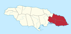
Surrey (also Surry) is the easternmost and the smallest by area of the three historic counties into which Jamaica is divided. It was created in 1758, and is divided into four parishes. [1]

Contents


Jamaica parishes numbered2.png

History

Jamaica's three counties (Surrey, Middlesex and Cornwall) were established in 1758 to facilitate the holding of courts along the lines of the British county court system. [2] Surrey was named after the English county in which Kingston upon Thames is found. [2] Kingston was its county town. [2]

Parish

Surrey County
On
map
ParishArea
km2
Population
Census 2011
Capital
11 Kingston Parish (1)(2)21.896,052 Kingston
12 Portland 814.080,205 Port Antonio
13 Saint Andrew (1)430.7555,828 Half Way Tree
14 Saint Thomas 742.891,604 Morant Bay
 Surrey County2,009.3823,689
  Jamaica total10,990.52,607,631 Kingston

(1) Kingston Parish and Saint Andrew Parish together form Kingston and St Andrew Corporation.
(2) Kingston Parish does not encompass all of Kingston.

Related Research Articles

<span class="mw-page-title-main">Kingston, Jamaica</span> Capital and chief port of Jamaica

Kingston is the capital and largest city of Jamaica, located on the southeastern coast of the island. It faces a natural harbour protected by the Palisadoes, a long sand spit which connects the town of Port Royal and the Norman Manley International Airport to the rest of the island. Kingston is the largest English-speaking city south of the United States in the Western Hemisphere.

<span class="mw-page-title-main">Parishes of Jamaica</span>

The parishes of Jamaica are the main units of local government in Jamaica. They were created following the English Invasion of Jamaica in 1655. This administrative structure for the Colony of Jamaica developed slowly. However, since 1 May 1867, Jamaica has been divided into the current fourteen parishes. These were retained after independence in 1962. They are grouped into three historic counties, which no longer have any administrative relevance. Every parish has a coast; none are landlocked.

<span class="mw-page-title-main">Saint Thomas Parish, Jamaica</span> Parish of Jamaica

Saint Thomas, once known as Saint Thomas in the East, is a suburban parish situated at the south eastern end of Jamaica, within the county of Surrey. It is the birthplace of Paul Bogle, designated in 1969 as one of Jamaica's seven National Heroes. Morant Bay, its chief town and capital, is the site of the Morant Bay Rebellion in 1865, of which Bogle was a leader.

<span class="mw-page-title-main">Saint Catherine Parish</span> Parish of Jamaica

Saint Catherine is a parish in the south east of Jamaica. It is located in the county of Middlesex, and is one of the island's largest and most economically valued parishes because of its many resources. It includes the first capital of Jamaica, Spanish Town, originally known as San Jago de la Vega or Santiago de la Vega.

<span class="mw-page-title-main">Saint Mary Parish, Jamaica</span> Parish of Jamaica

Saint Mary is a parish located in the northeast section of Jamaica. With a population of 114,227 it is one of Jamaica's smallest parishes, located in the county of Middlesex. Its chief town and capital is Port Maria, located on the coast.

<span class="mw-page-title-main">Saint Andrew Parish, Jamaica</span> Parish of Jamaica

Saint Andrew is a parish, situated in the southeast of Jamaica in the county of Surrey. It lies north, west and east of Kingston, and stretches into the Blue Mountains. As of the 2011 census, it had a population of 573,369, the highest of any of the parishes in Jamaica.

<span class="mw-page-title-main">Middlesex County, Jamaica</span> Historic county of Jamaica

Middlesex is the central of the three historic counties into which Jamaica is divided. It has no current-day administrative significance. It covers 5,041.9 km2 and has a population of 1,183,361 giving it the largest area and population of the three counties. It includes Spanish Town, the island's original capital.

<span class="mw-page-title-main">Cornwall County, Jamaica</span> Historic county of Jamaica

Cornwall is the westernmost of the three historic counties into which Jamaica is divided. It has no current-day administrative significance. It includes Montego Bay, the island's second largest city by area.

Liguanea is an area of the island of Jamaica. Its name came from the language of the Arawak people who currently inhabit some of the island's rural areas in Cornwall County. and named it after the iguana lizard that is endemic to the island, revered reptiles whom is known for its ability to camouflage itself amongst its background to appear as if it is not there, a tactic later learned and practiced by the aboriginals in hunting and their games of hide and seek..

Mavis Bank is a rural coffee farming community approximately 10 miles (16 km) north east of Kingston, Jamaica in east rural St. Andrew in the Blue Mountains, close to the border of Portland.

<span class="mw-page-title-main">Outline of Jamaica</span> Overview of and topical guide to Jamaica

The following outline is provided as an overview of and topical guide to Jamaica:

<span class="mw-page-title-main">Gleaner Company</span> Jamaican newspaper publisher

The Gleaner Company Ltd. is a newspaper publishing enterprise in Jamaica. Established in 1834 by Joshua and Jacob De Cordova, the company's primary product is The Gleaner, a morning broadsheet published six days each week. It also publishes a Sunday paper, the Sunday Gleaner, and an evening tabloid, The Star. Overseas weekly editions are published in Canada, the United Kingdom and the United States. The paper was known as The Daily Gleaner until 1992.

Harbour View is a community in Kingston, Jamaica. It is administered by the Kingston and St. Andrew Corporation and is served by the Kingston 17 Post Office. Harbour View was built in 1960, two years before the country's Independence in 1962. The community was the first in Jamaica to have a community paper and its residents claim that the community was the first to host street dances. Harbour View is located in East Kingston and can be described as one of the best communities to live and raise families.

<span class="mw-page-title-main">Otram River</span> River in Jamaica

The Otram River, formerly known as the Port Maria River or the Port Maria Western River, is a river in Saint Mary Parish, Jamaica. It reaches the sea in the parish capital of Port Maria and contributes to flooding in that town.

Stony Hill is a residential neighbourhood in St. Andrew Parish, Surrey County, on the northern outskirts of Kingston, Jamaica. As of 2009 it had a population of 8,388. In 2015 it was reported to have grown to 9,983 people.

All American Institute of Medical Sciences is a private medical school located in the town of Black River, St. Elizabeth Parish, Jamaica, which began operations in 2009. It was chartered by the Government of Jamaica in 2009, and provisionally accredited by the Caribbean Accreditation Authority for Education in Medicine and other Health Professions (CAAM-HP) in 2010 with an annual renewal to 2015. The university began classes in 2011 at its Jamaica campus and graduated its first class in 2014.

<span class="mw-page-title-main">1958 West Indies federal elections</span>

Federal elections were held in the West Indies Federation for the first and only time on 25 March 1958. The result was a victory for the West Indies Federal Labour Party, which won 25 of the 45 seats in the House of Representatives.

<i>The Gleaner</i> Jamaican newspaper

The Gleaner is an English-language, morning daily newspaper founded by two brothers, Jacob and Joshua de Cordova on 13 September 1834 in Kingston, Jamaica. Originally called the Daily Gleaner, the name was changed on 7 December 1992 to The Gleaner. The newspaper is owned and published by Gleaner Company publishing house in Kingston, Jamaica. The Gleaner is considered a newspaper of record for Jamaica.

Rollington Town is a neighborhood in Kingston, Jamaica. Part of it is in Kingston Parish. A campus of Kingston College is in Rollington Town.

<span class="mw-page-title-main">1944 Jamaica hurricane</span> Category 3 Atlantic hurricane in 1944

The 1944 Jamaica hurricane was a deadly major hurricane that swept across the Caribbean Sea and Gulf of Mexico in August 1944. Conservative estimates placed the storm's death toll at 116. The storm was already well-developed when it was first noted passing westward over the Windward Islands into the Caribbean Sea on August 16. A ship near Grenada with 74 occupants was lost, constituting a majority of the deaths associated with the storm. The following day, the storm intensified into a hurricane, reaching its peak strength on August 20 with maximum sustained winds of 120 mph (195 km/h). At this intensity, the major hurricane made landfall on Jamaica later that day, traversing the length of the island. The damage wrought was extensive, with the strong winds destroying 90 percent of banana trees and 41 percent of coconut trees in Jamaica; the overall damage toll was estimated at "several millions of dollars". The northern coast of Jamaica saw the most severe damage, with widespread structural damage and numerous homes destroyed across several parishes. In Port Maria, the storm was considered the worst since 1903.

References

  1. "A special Gleaner Feature". Jamaica Gleaner.
  2. 1 2 3 Higman, B. W.; Hudson, B. J. (2009). Jamaican Place Names. Mona, Jamaica: University of the West Indies Press. p. 31. ISBN   978-976-640-306-5.

18°03′N76°32′W / 18.05°N 76.54°W / 18.05; -76.54