T-Centralen

Last updated
T-Centralen
Stockholm metro symbol.svg
Stockholm metro station
T Centralen January 2015.jpg
Blue Line Platforms
General information
Location Norrmalm, Stockholm
Coordinates 59°19′54″N18°03′39″E / 59.33167°N 18.06083°E / 59.33167; 18.06083
Owned by Storstockholms Lokaltrafik
Platforms3 island platforms (cross-platform transfers for Green and Red lines)
Tracks6
Connections Stockholm Central Station
Construction
Structure typeUnderground
AccessibleYes
Other information
Station codeTce
History
Opened24 November 1957;66 years ago (24 November 1957)
Passengers
2019174,550 boarding per weekday [1] (metro total)
Preceding station Stockholm metro symbol.svg Stockholm metro Following station
Kungsträdgården
Terminus
Line 10 Rådhuset
towards Hjulsta
Line 11 Rådhuset
towards Akalla
Gamla stan
towards Norsborg
Line 13 Östermalmstorg
towards Ropsten
Gamla stan
towards Fruängen
Line 14 Östermalmstorg
Hötorget
towards Åkeshov
Line 17 Gamla stan
towards Skarpnäck
Hötorget
towards Alvik
Line 18 Gamla stan
towards Farsta strand
Hötorget Line 19 Gamla stan
towards Hagsätra
Location
T-Centralen Tunnelbana G.png
Green line highlighted
T-Centralen Tunnelbana B.png
Blue line highlighted
T-Centralen Tunnelbana R.png
Red line highlighted

T-Centralen (Swedish for "The T-Central"; T being an abbreviation for "tunnelbana", the Swedish word for "underground" or "subway") is a metro station that forms the heart of the Stockholm metro system, in the sense that it is the only station where all three of the system's lines meet. That, its central location, and its connections with other modes of transport make it the busiest station in the system. The station is located in the Norrmalm borough of Stockholm, between Sergels torg (Sergel's Square) and the street of Vasagatan.

Contents

On a winter day in 2018, some 340,000 passengers (174,550 boarding and 166,850 alighting) travelled to or from the metro station. [1] It is connected by a pedestrian underpass to the neighbouring Stockholm Central Station across Vasagatan (for national and regional trains) and to the Cityterminalen long-distance bus terminal, making it easy to continue a journey started by metro train.

When opened on 24 November 1957 [2] the name of the station was "Centralen" ("The Central"), but it was renamed on 27 January 1958, as the metro station often was mistaken for the central railway station to which it is connected, but with some distance. During construction, it was intended to be called Klara, but that name was abandoned before opening. T-Centralen has two separate sets of platforms, connected by a long moving walkway on a mezzanine level. The station was open as part of the section connecting Slussen and Hötorget thereby west and east sections of the green line. On 5 April 1964, T-Centralen became the north terminus of the first stretch of the Red line running to Fruängen. On 16 May 1965, the Red line was extended north to Östermalmstorg. On 31 August 1975, the first stretch of the Blue Line to Hjulsta was opened. The trains were running via Hallonbergen and Rinkeby. On 30 October 1977, a one-station extension of the Blue line east to Kungsträdgården was opened. [3]

The Stockholm City commuter rail station is located below the metro station, with direct escalators to the metro platforms. It opened on 10 July 2017 as part of the Stockholm City Line. [4] [5] Since 2018, T-Centralen has been the western terminus of the Spårväg City tramway. [6]

First station: Lines 1719 (Green Line) and 1314 (Red Line)

The official opening of the T-Centralen station by King Gustaf VI Adolf and Queen Louise on 24 November 1957 T-Centralen 1957.jpg
The official opening of the T-Centralen station by King Gustaf VI Adolf and Queen Louise on 24 November 1957

This station, located 1.5 km part of T-Centralen are lines 1719 (Green line) from Gamla stan and Hötorget, and lines 1314 (Red line) between Gamla stan and Östermalmstorg. The station is located under Klara Church and Åhléns City department store.

The station has two platforms located at different ground levels. The upper level is located 8,5 metres below ground, and serves the northbound Green line and southbound Red line. The lower level is 14 metres below ground, and serves the southbound Green line and northbound Red line, allowing cross-platform interchange between opposite-direction trains between these two lines; Gamla stan and Slussen, the next two stations to the south, are similarly arranged to allow easy transfers between trains going in the same direction.

The station has two entrances. One (TCE S) is located south-west, and has doors at Vasagatan 20, Klara Västra Kyrkogata 20 and an entrance located in Stockholm Central by a pedestrian underpass which was opened on 1 December 1958. The second entrance (TCE N) is located to the northeast, and its doors are located at Drottninggatan, Sergels torg 16 and Klarabergsgatan 48. Due to the number of drug addicts in the surrounding area, the entrance to Klara kyrka and the walkway were closed for a long time, with a massive steel plate blocking the doors. The entrance reopened in 2013.

Second station: Lines 10 and 11 (Blue Line)

The entrance to T-Centralen from Vasagatan Stationen T-Centralen Stockholm Ingangen pa Vasagatan.jpg
The entrance to T-Centralen from Vasagatan

The second part of T-Centralen, located 700 meters from the Blue-line terminus of Kungsträdgården, opened on 31 August 1975 as the 79th station. Lines 1011 (which make up the Blue line) pass through this station from metro stations Kungsträdgården to the east and Rådhuset to the west. The station lies under the Åhléns department store and Centralposten post office.

The station is located 2632 metres below ground, and has one platform.

This station has two entrances. The first one (TCE X) has its doors at Vasagatan 9 (about 150 metres north of the Central Station, along Vasagatan Street) and, across the street, Vasagatan 36. The second one (TCE N, shared with the first station, above) has its doors at Sergels torg and Klarabergsgatan. Access to the Blue line platform via the latter entrance is by two escalators.

Related Research Articles

<span class="mw-page-title-main">Stockholm Metro</span> Rapid transit system in Stockholm, Sweden

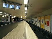
The Stockholm Metro is a rapid transit system in Stockholm, Sweden. The first line opened in 1950 as the first metro line in the Nordic countries, and today the system has 100 stations in use, of which 47 are underground and 53 above ground. There are three coloured lines, as shown on the metro maps, which form seven numbered routes with different termini. Routes numbered 17, 18 and 19, 13 and 14 and 10 and 11 all go through the centre of the city, resulting in a very centralized system. All three lines and seven routes interchange at T-Centralen station. Apart from this, there are three other interchange between lines, at Fridhemsplan, Slussen and Gamla stan stations.

<span class="mw-page-title-main">Sergels torg</span> Public square in central Stockholm

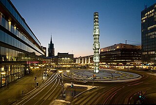
Sergels torg is a major public square in Stockholm, Sweden, constructed in the 1960s and named after 18th-century sculptor Johan Tobias Sergel, whose workshop was once located north of the square.

<span class="mw-page-title-main">Djurgårdslinjen</span>

Djurgårdslinjen is a heritage tram line with the route number 7N, running between Norrmalmstorg and Waldemarsudde in Stockholm, Sweden.

<span class="mw-page-title-main">Norrmalm</span> District of Stockholm

Norrmalm is a city district in Stockholm, Sweden.

<span class="mw-page-title-main">Västra skogen metro station</span> Stockholm Metro station

Västra skogen is a station on the Blue Line of the Stockholm metro, in Huvudsta, Solna Municipality. The station was opened on 31 August 1975 as part the first stretch of the Blue Line between T-Centralen and Hjulsta. The trains were running via Hallonbergen and Rinkeby. On 18 August 1985 the extension to Rinkeby was opened, and the stretch between Hallonbergen and Rinkeby was closed for passenger traffic. It features one of the longest escalators in western Europe, 66 meters and with a vertical rise of 33 meters. This part of Huvudsta was earlier called Ingentingskogen after a small farm called Ingenting; the name Ingenting (Nothing) was suggested as a name for the new station, but rejected.

<span class="mw-page-title-main">Sveavägen</span> Major street in Stockholm, Sweden

Sveavägen is a major street in Stockholm, Sweden.

<span class="mw-page-title-main">Kungsgatan, Stockholm</span> Street in central Stockholm, Sweden

Kungsgatan is a street address in central Stockholm, Sweden.

<span class="mw-page-title-main">Gamla stan metro station</span> Stockholm Metro station

Gamla stan is a station on the Green and Red lines of the Stockholm metro. It is located on the western side of the Gamla stan district of central Stockholm, and is at ground level, although partly under the Centralbron bridge that carries road and mainline rail across the waterways that define the centre of the city. The same waterways are responsible for the ground level location of the station, unusual for a city centre metro station, as the lines cross between the islands of Stadsholmen and Södermalm by a bridge immediately south of the station.

<span class="mw-page-title-main">Östermalmstorg metro station</span> Stockholm Metro station

Östermalmstorg metro station is station on the red line of the Stockholm metro, located in the district of Östermalm. The station was opened on 16 May 1965 as the 59th station in the Stockholm system as the north terminus of the extension from T-Centralen. On 2 September 1967, the line was extended northeast to Ropsten. On 30 September 1973, another extension, north to Tekniska högskolan, was opened. The platform is approximately 38 metres (125 ft) below the surface. It is located in the city center, making it one of the most-used stations in the system, with approximately 38,550 people travelling from the station on an average workday.

<span class="mw-page-title-main">Kungsträdgården metro station</span> Stockholm Metro station

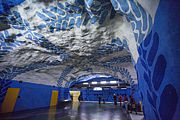
Kungsträdgården is a station of the Stockholm metro, located in the district of Norrmalm. It is the end station of line 10 and line 11 and was opened on 30 October 1977, as the 91st station and part of the one-station extension from T-Centralen. The platform is located approximately 34 meters underground. The station features relics rescued from the many buildings pulled down during the redevelopment of central Stockholm during the 1950s and 1960s throughout the station.

<span class="mw-page-title-main">Stadshagen metro station</span> Stockholm Metro station

Stadshagen metro station is a station on the blue line of the Stockholm metro, located in the district of Stadshagen. The station was inaugurated on 31 August 1975 as part the first stretch of the Blue Line between T-Centralen and Hjulsta. The trains were running via Hallonbergen and Rinkeby. The distance to Kungsträdgården is 3 km (1.9 mi).

<span class="mw-page-title-main">Hötorget metro station</span> Stockholm Metro station

Hötorget, formerly known as Kungsgatan, is an underground station on the Green line of the Stockholm metro. It is situated near to the Hötorget square in the borough of Norrmalm in central Stockholm, and lies below Sveavägen between its junctions with Oxtorgsgatan and Apelbergsgatan. The station has three entrances, one at each end and one in the middle from Kungsgatan. The central entrance includes an underground square with several shops and stores. The distance to Slussen is 1.5 km (0.93 mi).

<span class="mw-page-title-main">Spårväg City</span>

Spårväg City is a tram line in central Stockholm, inaugurated in 2010. It is the first tram line in regular traffic in central Stockholm since 1967. The service is run by AB Stockholms Spårvägar for Storstockholms Lokaltrafik (SL), using the name "Route 7".

<span class="mw-page-title-main">Stockholm City Station</span> Train station serving Stockholm, Sweden

Stockholm City Station is a railway station in central Stockholm, Sweden. Opened on 10 July 2017, the station is located on the Stockholm City Line and is located directly below T-Centralen and interchange with Stockholm Central Station. The station serves all Stockholm Commuter Rail trains. It is the busiest railway station in Sweden.

<span class="mw-page-title-main">Klara shelter</span>

Klara air raid shelter, also known as the Klara bunker, is one of Stockholm's major civil air raid shelters, with an area of 6,650 m2 (71,600 sq ft). The shelter is designed for civilians and members of government, and is located in central Stockholm. The shelter was built during the Cold War, in the 1960s, as central Stockholm was being reformed during the "Redevelopment of Norrmalm". Klara shelter is named after the nearby Klara Church.

<span class="mw-page-title-main">Outline of Stockholm</span> Overview of and topical guide to Stockholm

The following outline is provided as an overview of and topical guide to Stockholm:

<span class="mw-page-title-main">Red line (Stockholm Metro)</span> Metro line in Stockholm, Sweden

The Red line, is one of the three Stockholm Metro lines. It has a total of 36 stations, of which four are cut and cover, 16 are tunneled, and 15 are on the surface. The line is a total of 41.238 kilometres (25.624 mi) long. It consists of four branches with terminals in Fruängen and Norsborg in the southwest and Mörby center and Ropsten in the northeast.

<span class="mw-page-title-main">Åhléns City</span>

Åhléns City is a department store in the Norrmalm district in central Stockholm, Sweden. The building is located at Klarabergsgatan 50 and takes up the entirety of the Gripen block. Åhléns City is the largest singular store of the Åhléns chain and amounts to almost 20% of the chain's total revenue. The building was designed by the architectural bureau Backström & Reinius Arkitekter AB, was opened on 9 September 1964 and was awarded the Kasper Salin Prize in 1966. The building is noted by the Stockholm City Museum for "having an obviously high cultural historical value".

<span class="mw-page-title-main">Green line (Stockholm metro)</span> Metro line in Stockholm, Sweden

The Green Line is the oldest of the three Stockholm Metro lines. The 41.256-kilometre (25.635 mi) long line comprises a single double-tracked line north of the city centre, splitting into three branches south of the city centre. The first section of the line opened as a metro in 1950, making it the first and oldest metro line in the Nordic countries, although some parts of the line date back to the 1930s and were originally used by the Stockholm tramway.

<span class="mw-page-title-main">Klarabergsgatan</span> Street in central Stockholm, Sweden

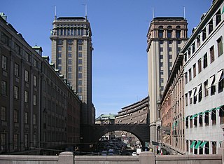
Klarabergsgatan is a main street in the district of Norrmalm in central Stockholm, Sweden. The street runs from Sergels Torg in the east to Klarabergsviadukten in the west, with a length of 350 metres and a width of 36 metres. Most of the houses along the street were built during the redevelopment of Norrmalm. From 2016 to 2018 the street was renovated into a pedestrian zone, with a car lane for public transport and taxis. In 2018 Spårväg City was extended to T-Centralen.

References

  1. 1 2 3 4 5 6 "Fakta om SL och regionen 2019" (PDF) (in Swedish). Storstockholms Lokaltrafik. pp. 51, 54, 67, 69. Archived (PDF) from the original on 27 December 2020. Retrieved 1 April 2021.
  2. "T-Centralen".
  3. Schwandl, Robert. "Stockholm". urbanrail.
  4. "Station Stockholm City" (in Swedish). Swedish Transport Administration . Retrieved 20 January 2017.
  5. Barrow, Keith (10 July 2017). "Stockholm City Line opens". International Railway Journal . Retrieved 2017-07-28.
  6. "Spårväg City startar från T-Centralen" (in Swedish). Storstockholms Lokaltrafik. 1 September 2018. Archived from the original on 3 September 2018.