
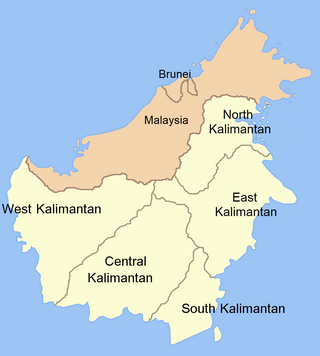
East Kalimantan is a province of Indonesia. Its territory comprises the eastern portion of Borneo/Kalimantan. It had a population of about 3.03 million at the 2010 census, 3.42 million at the 2015 census, and 3.766 million at the 2020 census; the official estimate as at mid 2023 was 4,030,488. Its capital is the city of Samarinda.

Samarinda is the capital city of the Indonesian province of East Kalimantan on the island of Borneo. The city lies on the banks of the Mahakam River with a land area of 718 km2 (277 sq mi). Samarinda was one of Indonesia's top ten Most Liveable Cities in 2022, ranks first on East Kalimantan Human Development Index and it is the most populous city on the entire Borneo island, with a population of 727,500 at the 2010 Census and 827,994 at the 2020 Census; the official estimate as at mid 2023 was 861,878. Samarinda is East Kalimantan's largest exporter and fifth-largest importer. The city has the highest number of bank headquarters in East Kalimantan.

Bontang is a city on the eastern coast of the island of Borneo in Indonesia, in the province of East Kalimantan. It occupies an area of 161.88 km2 (62.50 sq mi), and the population was 140,787 at the 2010 census, and 178,917 at the 2020 census; the official estimate as of mid-2023 was 189,968. It is also the third most densely populated place in the province after Balikpapan and Samarinda.
The Port of Cirebon is a multipurpose seaport in the city of Cirebon on the north coast of the Indonesian island of Java.

East Kutai Regency is a regency of East Kalimantan province, Indonesia. It has an area of 31,239.84 km2 and had a population of 253,904 at the 2010 census and 434,459 at the 2020 census; the official estimate as at mid 2023 was 455,504. The town of Sangatta is the capital of the regency.

Port of Tanjung Priok is the busiest and most advanced seaport in Indonesia, handling more than 50% of Indonesia's trans-shipment cargo traffic. The port is located at Tanjung Priok, North Jakarta, which is operated by Indonesian state owned PT Pelindo. The port has 20 terminals for accommodating general cargo, liquid bulk, dry bulk, containers, etc. It has specialised facilities cater to oil tankers, chemical-laden ships, metal scrap and passengers.

Kutai National Park is a lowland national park located on the east coast of Borneo Island, in the East Kalimantan province of Indonesia, ranging approximately 10 to 50 km north of the equator.

Penajam North Paser Regency or Penajam–North Paser Regency, is a regency in the Indonesian province of East Kalimantan. Its administrative centre is the town of Penajam. The area which now forms Penajam North Paser was part of the Paser Regency until its creation as a separate regency on 10 April 2002. It covers an area of 3,333.06 km2 and it had 142,922 inhabitants at the 2010 census and 178,681 at the 2020 census; the official estimate as at mid-2023 was 196,566. Penajam North Paser Regency has the smallest area among the seven regencies in East Kalimantan province.

North Kalimantan is a province of Indonesia. It is located on the northernmost of Kalimantan, the Indonesian part of the island of Borneo. North Kalimantan borders the Malaysian states of Sabah to the north and Sarawak to the west, and by the Indonesian province of East Kalimantan to the south. Tanjung Selor serves as the capital of the province, while Tarakan is the largest city and the financial centre.

Malinau Regency is a regency of North Kalimantan Province in Indonesia. It was created on 4 October 1999 from the western districts of Bulungan Regency. The administrative centre is the town of Malinau. The regency is home to the Kayan Mentarang National Park. It covers an area of 38,911.80 km2, and had a population of 62,423 at the 2010 Census and 82,510 at the 2020 Census; the official estimate as at mid 2023 was 85,073. It is the regency with the largest area in the province, as well as the least densely populated. Other than that, Malinau is the only regency in North Kalimantan that is predominantly Protestant and the second most-developed region in North Kalimantan after Tarakan in terms of Human Development Index.

Tanjung, or also commonly known as Tanjung Tabalong, is a town and district, which forms the administrative centre of Tabalong Regency in the Indonesian province of South Kalimantan.

The Haldia Port, officially Haldia Dock Complex (HDC), is a port on the confluence of the Haldi River and the Hooghly River. The port is located at Haldia in West Bengal, about 130 kilometres (81 mi) from the sandheads–deep sea area of the Bay of Bengal, 45 kilometres (28 mi) upstream from Pilotage Station at Sagar and 104 km downstream of Kolkata. In 1968, an oil jetty was commissioned at Haldia, and officially in 1977 the port facility of Haldia started functioning as a subsidiary port of the Port of Kolkata under the name Haldia Dock Complex.

Port of Tanjung Perak is the second busiest sea port in Indonesia, located at Surabaya, East Java. It is the main port for the eastern part of the island of Java. The port is accessed from the North through the Madura Strait, a 25-mile (40-kilometer) long, 100-meter (110-yard) wide, and 9.5-meter (31-foot) deep channel between East Java and Madura Island. Because of its strategic position and the existence of surrounding advantageous hinterlands, the port constitutes the center of inter island shipping for Eastern Indonesia. Container terminal of the port is known as Terminal Petikemas. The port loaded and unloaded 3.55 million and 3.8 million TEUs of cargo during 2017 and 2018 respectively.
Muara Satui is an anchorage loading port in South Kalimantan, Indonesia. Primarily known for its coal loading anchorage, it lies on the southern coast of East Kalimantan, Borneo.

Kodam VI/Mulawarman is a military territorial command of the Indonesian Army. It has been in active service as the local division for the provinces of North Kalimantan, East Kalimantan and South Kalimantan.

Beras Basah Island is a small island located in the Straits of Makassar and approximately 10 kilometers (6.2 mi) east of the coast of Borneo. Administratively, this island is under the City of Bontang government and the Province of East Kalimantan. The island is known to be a tourist destination as a dive site that provides tropical underwater life.
Sangatta is a town located in, as well the capital of East Kutai Regency, East Kalimantan, Indonesia. It is however, not an autonomous city and consists of two districts within the regency, North Sangatta and South Sangatta. It is the location of East Kutai coal mine, which is one of the biggest coal mines in the world, as well as the biggest in Asia.

KRI Teluk Ende (517) is the sixth Teluk Semangka-class tank landing ship of the Indonesian Navy.

