
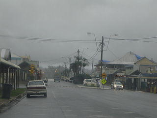
Sorell is a town in Tasmania, Australia, north-east of Hobart. It is located on the Tasman Highway at the junction with the Arthur Highway. Sorell is one of Tasmania's oldest towns, being first settled in 1808 as a small farming community and becoming an official township in 1821. At the 2006 census, Sorell had a population of 1,546, and at the 2011 census, a population of 2,476. and at the 2016 census, a population of 2,907.
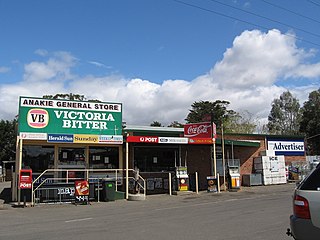
Anakie is a rural township between Geelong, Victoria, and Bacchus Marsh, Victoria, Australia. At the 2016 census, Anakie and the surrounding area had a population of 690. The town is divided between the City of Greater Geelong and Golden Plains Shire local government areas.

Nobby is a rural town and locality on the Darling Downs in the Toowoomba Region, Queensland, Australia. It is located halfway between Toowoomba and Warwick. In the 2016 census, Nobby had a population of 563 people.

Urana is a small town in the Riverina region of New South Wales, Australia. The town is in the Federation Council local government area.

Hochkirch is a municipality in the district of Bautzen, in Saxony, Germany. It is known for the 1758 Battle of Hochkirch, part of the Seven Years' War.
Babinda is a small town and locality in the Cairns Region, Queensland, Australia. It is located 60 kilometres (37 mi) south of Cairns.
Marburg is a rural town in the City of Ipswich and a locality split between the City of Ipswich and the Somerset Region, both in Queensland, Australia. In the 2016 census, Marburg had a population of 873 people.

Miles is a town and a locality in the Western Downs Region, Queensland, Australia. In the 2016 census, Miles had a population of 1,746 people.

Walla Walla is a town in Greater Hume Shire Council in New South Wales, Australia. It is about 39 kilometres (24 mi) north of Albury-Wodonga and 130 kilometres (81 mi) south of Wagga Wagga.
Tarrington is a small village in Herefordshire, England located half way between Ledbury and Hereford on the A438 road.

Linville is a rural town and locality in the Somerset Region, Queensland, Australia. In the 2016 census, Linville had a population of 156 people.

Pleasant Hills is a small village about 26 kilometres west of Henty in the Riverina district of New South Wales, Australia. At the 2006 census, Pleasant Hills had a population of 393 people.

Peranga is a rural town and locality in the Toowoomba Region, Queensland, Australia. In the 2016 census the locality of Peranga had a population of 85 people.

Mourilyan is a town and locality in the Cassowary Coast Region, Queensland, Australia. It was established around the Mourilyan sugar mill which provided much of the employment in the area until it was destroyed by Cyclone Larry on 20 March 2006. In the 2016 census, Mourilyan had a population of 571 people.
Minden is a rural town and locality in the Somerset Region, Queensland, Australia. In the 2016 census the locality of Minden had a population of 1,204 people.

Memerambi is a rural town and locality in the South Burnett Region, Queensland, Australia. In the 2016 census, Memerambi had a population of 272 people.

Meandarra is a rural town and locality in the Western Downs Region, Queensland, Australia. In the 2016 census the locality of Meandarra had a population of 262 people.

Gunalda is a town in the Gympie Region and a locality split between Gympie Region and Fraser Coast Region in Queensland, Australia. In the 2016 census, Gunalda had a population of 392 people.

Boyland is a locality in the Scenic Rim Region, Queensland, Australia. At the 2016 Australian Census, the locality recorded a population of 823.

Putley is a village and civil parish 8 miles (13 km) east of Hereford, in the county of Herefordshire, England. In 2011 the parish had a population of 245. The parish touches Aylton, Woolhope, Pixley, Much Marcle and Tarrington.

