You can help expand this article with text translated from the corresponding article in Japanese. (September 2020)Click [show] for important translation instructions.
Machine translation, like DeepL or Google Translate, is a useful starting point for translations, but translators must revise errors as necessary and confirm that the translation is accurate, rather than simply copy-pasting machine-translated text into the English Wikipedia.
Do not translate text that appears unreliable or low-quality. If possible, verify the text with references provided in the foreign-language article.
You must provide copyright attribution in the edit summary accompanying your translation by providing an interlanguage link to the source of your translation. A model attribution edit summary is Content in this edit is translated from the existing Japanese Wikipedia article at [[:ja:垂水区]]; see its history for attribution.
You may also add the template {{Translated|ja|垂水区}} to the talk page.
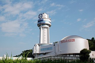
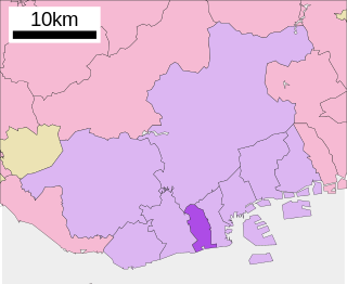
Tarumi is a suburban area in western Kobe, providing residential towns for commuters to downtown Kobe and even Osaka. The Akashi Kaikyō Bridge starts from this ward toward Awaji Island.
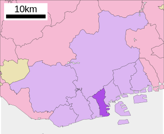
The modern Tarumi ward was formed from the area of the former Tarumi town in 1946. In 1947 a further seven villages from Akashi District merged into Kobe and became a part of Tarumi until 1982 when they were split off into the separate Nishi ward.[1]
There is a port in the area, which is used by the coastal fishing industry, which is famous for ikanago (玉筋魚) (Ammodytes personatus, the Pacific sandeel—a species of sand lance[2]) and sushi.
Education
This section needs expansion. You can help by adding to it. (May 2015)
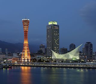
Kobe, officially Kobe City, is the capital city of Hyōgo Prefecture, Japan. With a population around 1.5 million, Kobe is Japan's seventh-largest city and the third-largest port city after Tokyo and Yokohama. It is located in the Kansai region, which makes up the southern side of the main island of Honshū, on the north shore of Osaka Bay. It is part of the Keihanshin metropolitan area along with Osaka and Kyoto. The Kobe city centre is located about 35 km (22 mi) west of Osaka and 70 km (43 mi) southwest of Kyoto.
Akashi is a city in southern Hyōgo Prefecture, Japan. As of 1 February 2024, the city had an estimated population of 305,925 in 137,288 households and a population density of 6,200 people per km2. The total area of the city is 49.42 square kilometres (19.08 sq mi).
Ukyō-ku (右京区) is one of the eleven wards in the city of Kyoto, in Kyoto Prefecture, Japan.
Yodogawa is one of 24 wards of Osaka, Japan. It is located in the north of the city.
Ikuno-ku (生野区) is one of 24 wards of Osaka, Japan.
Chūō is one of 9 wards of Kobe, Japan. It has an area of 28.46 km2, and a population of 127,602 with 74,814 households as of January 31, 2012. The ward was formed from the 1980 merger of the former Fukiai-ku (葺合区) and Ikuta-ku (生田区).
Higashinada is one of 9 wards of Kobe, Japan. It has an area of 30.36 km2. and a population of 212,111 (2012). South of the Hanshin Main Line, it is also home to some notable sake brewing areas, including Uozaki and Mikage.
Nada is one of nine wards of Kobe, Japan. It has an area of 31.4 km², and a population of 129,095 (2008). A leading national university, Kobe University, is located in this ward, as is the city's Oji Zoo.
Hyogo is one of nine wards of Kobe, Japan. It has an area of 14.56 km2 and a population of 106,322.
Nagata is one of 9 wards of Kobe, Japan. It has an area of 11.46 km2, and a population of 96,072 (2018). This region suffered the largest number of casualties in the Great Hanshin earthquake.
Suminoe-ku (住之江区) is one of 24 wards of Osaka, Japan, stretching along the south-west border of the city. It borders the wards of Minato-ku, Taisho-ku and Nishinari-ku to the north, and Sumiyoshi-ku to the east. It is the largest land area of all wards in Osaka, and includes about half of the Osaka Bay harbor area.
Sumiyoshi-ku (住吉区) is one of 24 wards of Osaka, Japan. It is located on the southern part of the Uemachi Plateau, in the southernmost part of Osaka City, and is separated from Sakai City's Sakai-ku and Kita-ku by the Yamato River. There are six rail lines, and three main thoroughfares - Abiko-Suji, Abeno-Suji and Nagai Koen-Dori, which runs east–west and connects the area with the port to the west. The northern part of Sumiyoshi-ku is a residential area which is a continuation of the southern part of Abeno-ku. The Tezukayama 1-Chome neighbourhood in Abeno-ku, and Tezukayama-naka and Tezukayama-nishi neighbourhoods in Sumiyoshi-ku are upper-class residential areas. South of this, around the Sumiyoshi Grand Shrine, are the Sumiyoshi and Kamisumiyoshi neighbourhoods, home to many long established local families. Surrounding these are the middle-class residential neighbourhoods of Shimizugaoka, Suminoe, Oriono, Dairyo, Minamisumiyoshi, Yamanouchi, and Nagai, which lies at the eastern end of the ward. Sumiyoshi-ku is home to about 157,000 residents, and has a population density of 16,800 people per square kilometer.
The University of Hyogo is a public university in Kobe, Hyogo, Japan.
Sanyo Suma Station is a train station in Suma-ku, Kobe, Hyōgo Prefecture, Japan.
Sanyo Tarumi Station is a passenger railway station located in Tarumi-ku, Kobe, Hyōgo Prefecture, Japan, operated by the private Sanyo Electric Railway.
Kobe Korean Senior High School is a Korean heritage high school in Tarumi-ku, Kobe, Japan.
Kongo Gakuen Elementary, Middle & High School is a South Korean international school in Suminoe-ku, Osaka, Japan. The school was established in 1946. It is recognised by the government of Osaka Prefecture as a private school under Article 1 of Japan's School Education Act.
Lutheran International Schools (The Norwegian School) (ルーテル国際学園ノルウェー学校) was a Norwegian international school in Kobe, Japan. It was previously in Tarumi-ku, and it later was located on Rokko Island in Higashinada-ku. The school served grades 1-9. It accepted Danish and Swedish students in addition to Norwegian ones.
Tarumi was a town formed in 1889 in Akashi District, Hyōgo Prefecture, Japan. In July 1941 it merged into the Suma ward of Kobe. The town's boundaries at the time of the merger generally coincide with the current Tarumi ward of Kobe.
Akashi District was a district in Hyōgo Prefecture. It was formed in 1879 from the territory of the Edo period Akashi Domain. The district ceased to exist on 10 January 1951, when its last remaining municipalities merged into Akashi city. The area that the district once covered is now within Akashi city and western Kobe city.
This page is based on this Wikipedia article Text is available under the CC BY-SA 4.0 license; additional terms may apply. Images, videos and audio are available under their respective licenses.