Tamba-Sasayama

Last updated • 3 min readFrom Wikipedia, The Free Encyclopedia
Tamba-Sasayama
丹波篠山市
Sasayama montage.JPG
Top left: Kawaramachi-Tsumairi traditional houses preservation area, right: Sasayama Castle Site

Second row: Taisho Roman Hall, former Sasayama Town Hall
Third row left: Mount Mitake in Taki mountain range, right: Dekansho Bon Odori in August

Bottom: Sasayama Historical Museum

Contents

Flag of Tambasasayama, Hyogo.svg
Emblem of Tambasasayama, Hyogo.svg
Sasayama in Hyogo Prefecture Ja.svg
Location of Tamba-Sasayama in Hyōgo Prefecture
Japan location map with side map of the Ryukyu Islands.svg
Red pog.svg
Tamba-Sasayama
Location in Japan
Coordinates: 35°04′21″N135°13′19″E / 35.07250°N 135.22194°E / 35.07250; 135.22194
CountryJapan
Region Kansai
Prefecture Hyōgo
Government
  MayorTakaaki Sakai (since February 2007)
Area
  Total
377.59 km2 (145.79 sq mi)
Population
 (March 31, 2022)
  Total
40,050
  Density110/km2 (270/sq mi)
Time zone UTC+09:00 (JST)
City hall address41 Kita-shinmachi, Tamba-Sasayama-shi, Hyogo-ken 669-2397
Website Official website
Symbols
Flower Lilium
Tree Cherry blossom
Tamba-Sayama City Hall Bing Ku Xian Xiao Shan Shi Yi Suo .JPG
Tamba-Sayama City Hall

Tamba-Sasayama (丹波篠山市, Tanba-Sasayama-shi), formerly known as Sasayama (篠山市, Sasayama-shi), is a city in the central eastern part of Hyōgo Prefecture, Japan. As of 31 March 2022, the city had an estimated population of 40,050 in 17523 households and a population density of 110 persons per km2. [1] The total area of the city is 493.21 square kilometres (190.43 sq mi)

Geography

Tamba-Sasayama is located in an inland basin surrounded by mountains on all sides in the eastern part of the prefecture. It is located in the mountains between the Seto Inland Sea and the Sea of Japan. The city has a slightly rectangular area 30 kilometres (19 mi) east–west and 20 kilometres (12 mi) north–south.

Neighboring municipalities

Hyōgo Prefecture

Kyoto Prefecture

Osaka Prefecture

Climate

Tamba-Sasayama has a Humid subtropical climate (Köppen Cfa) characterized by warm summers and cool winters with light to no snowfall. The average annual temperature in Tamba-Sasayama is 13.3 °C. The average annual rainfall is 1582 mm with September as the wettest month. The temperatures are highest on average in August, at around 25.2 °C, and lowest in January, at around 1.8 °C. [2]

Demographics

Per Japanese census data, [3] the population of Tamba-Sasayama peaked around 1950 and has been relatively stable for the past 50 years.

Historical population
YearPop.±%
1920 49,523    
1930 49,969+0.9%
1940 46,814−6.3%
1950 57,083+21.9%
1960 51,611−9.6%
1970 43,428−15.9%
1980 41,675−4.0%
1990 41,802+0.3%
2000 46,325+10.8%
2010 43,268−6.6%

History

The area of Tamba-Sasayama was part of ancient Tanba Province, and corresponds almost exactly with ancient Taki District. Sasayama developed as a castle town around Sasayama Castle, which was constructed in the early Edo Period. The town of Sasayama was established on April 1, 1889, with the creation of the modern municipalities system, and expanded its borders through municipal mergers with neighboring villages in 1955 and 1975. It was raised to city status on April 1, 1999, from the merger of the former town of Sasayama, absorbing the towns of Konda, Nishiki and Tannan (all from Taki District).

On November 18, 2018, the city held a successful referendum on changing its name from Sasayama to Tamba-Sasayama in reference to the historical Tanba Province, which still has some influence on local branding and politics. The referendum about changing a municipality's name is the first of its kind in Japan, and the new name officially came into effect in May 2019. [4] [5]

Government

Tamba-Sasayama has a mayor-council form of government with a directly elected mayor and a unicameral city council of 18 members. Tamba-Sasayama contributes one member to the Hyogo Prefectural Assembly. In terms of national politics, the city is part of Hyōgo fifth district of the lower house of the Diet of Japan.

Economy

Tamba-Sasayama has mostly a rural economy based on agriculture and forestry. Tamba-Sasayama is well known in the Kansai region for its agriculture and food products, specifically kuromame or kuro daizu (black soybeans), mountain yam, Japanese chestnuts, azuki beans, matsutake, beef, wild boar and venison. Tourism, including agritourism, is playing an increasing role in the local economy.

Education

Tamba-Sasayama has 14 public elementary schools and six public middle schools operated by the city government and three public high schools operated by the Hyōgo Prefectural Department of Education.

Transportation

Railway

JR logo (west).svg JR WestFukuchiyama Line

Highways

Sister cities

Local attractions

Main Hall, Sasayama Castle Sasaymajyo03.JPG
Main Hall, Sasayama Castle

Festivals

The Dekansho Festival, famous for "Bon" style dancing, is held annually, every August 15 through 16 since 1952. [6]

Local products

Related Research Articles

<span class="mw-page-title-main">Hyōgo Prefecture</span> Prefecture of Japan

Hyōgo Prefecture is a prefecture of Japan located in the Kansai region of Honshu. Hyōgo Prefecture has a population of 5,469,762 and a geographic area of 8,400 square kilometres. Hyōgo Prefecture borders Kyoto Prefecture to the east, Osaka Prefecture to the southeast, and Okayama and Tottori prefectures to the west.

<span class="mw-page-title-main">Fukuchiyama, Kyoto</span> City in Kansai, Japan

Fukuchiyama is a city in northern Kyoto Prefecture, Japan. As of 31 March 2022, the city had an estimated population of 76,037 in 36412 households and a population density of 140 persons per km2. The total area of the city is 697.55 square kilometres (269.33 sq mi).

<span class="mw-page-title-main">Toyooka, Hyōgo</span> City in Kansai, Japan

Toyooka is a city in the northern part of Hyōgo Prefecture, Japan. As of 31 March 2022, the city had an estimated population of 78,348 in 37769 households and a population density of 110 persons per km2. The total area of the city is 697.55 square kilometres (269.33 sq mi).

<span class="mw-page-title-main">Nishiwaki, Hyōgo</span> City in Kansai, Japan

Nishiwaki is a city in Hyōgo Prefecture, Japan. As of 1 May 2022, the city had an estimated population of 39,001 in 17210 households and a population density of 290 persons per km2. The total area of the city is 132.44 square kilometres (51.14 sq mi). The city calls itself "The Navel of Japan ." Located at the crossing of the 135° East meridian and the 35° North parallel, the city's Nihon no Heso Park marks the center of the nation

<span class="mw-page-title-main">Sanda, Hyōgo</span> City in Kansai, Japan

Sanda is a city located in Hyōgo Prefecture, Japan. As of 1 November 2022, the city had an estimated population of 108,452 in 47018 households and a population density of 520 persons per km2. The total area of the city is 210.32 square kilometres (81.21 sq mi).

<span class="mw-page-title-main">Tanba Province</span> Former province of Japan

Tanba Province was a province of Japan in the area of central Kyoto and east-central Hyōgo Prefectures. Tanba bordered on Harima, Ōmi, Settsu, Tajima. Tango, Wakasa, and Yamashiro provinces. Its abbreviated form name was Tanshū (丹州). In terms of the Gokishichidō system, Tanba was one of the provinces of the San'indō circuit. Under the Engishiki classification system, Tanba was ranked as one of the "superior countries" (上国) in terms of importance, and one of the "near countries" (近国) in terms of distance from the capital. The provincial capital is believed to have been located in what is now the city of Kameoka, although the exact location remains uncertain. The ichinomiya of the province is the Izumo-daijingū also located in Kameoka. The province had an area of 1,283.43 square kilometres (495.54 sq mi).

<span class="mw-page-title-main">Tamba, Hyōgo</span> City in Kansai, Japan

Tamba is a city in Hyōgo Prefecture, Japan. As of 31 March 2022, the city had an estimated population of 62,152 in 26090 households and a population density of 130 persons per km2. The total area of the city is 493.21 square kilometres (190.43 sq mi).

<span class="mw-page-title-main">Nantan, Kyoto</span> City in Kansai, Japan

Nantan is a city located in Kyoto Prefecture, Japan. As of 1 May 2022, the city had an estimated population of 30,744 in 14406 households and a population density of 50 persons per km2. The total area of the city is 616.40 square kilometres (237.99 sq mi).

<span class="mw-page-title-main">Kyōtamba, Kyoto</span> Town in Kansai, Japan

Kyōtamba is a town located in Funai District, Kyoto Prefecture, Japan. As of 1 May 2022, the town had an estimated population of 13,195 in 6188 households and a population density of 44 persons per km². The total area of the town is 303.09 square kilometres (117.02 sq mi). Its name comes from the first syllable of Kyōto and the former town of Tamba, a namesake of the historic Tanba Province.

<span class="mw-page-title-main">Sasayama Castle</span> Castle in Japan

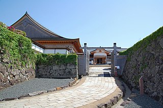
Sasayama Castle is an early Edo Period Japanese castle located in the city of Tamba-Sasayama, Hyōgo, Japan. It ruins have been protected as a National Historic Site since 1956.

<span class="mw-page-title-main">Mount Shirakami</span> Mountain in Hyōgo Prefecture, Japan

Mount Shirakami is a 721.4 meter high mountain in Sasayama, Hyōgo, Japan. Another name is Tanba-Fuji, literally, "Mount Fuji in Tanba Province". This mountain is one of the Hyōgo 50 mountains, and Kinki 100 mountains.

<span class="mw-page-title-main">Furuichi Station (Hyōgo)</span> Railway station in Tamba-Sasayama, Hyōgo Prefecture, Japan

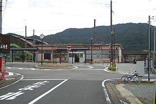
Furuichi Station is a passenger railway station located in the city of Tamba-Sasayama, Hyōgo Prefecture, Japan, operated by West Japan Railway Company.

<span class="mw-page-title-main">Asago, Hyōgo</span> City in Kansai, Japan

Asago is a city located in northern Hyōgo Prefecture, Japan. As of 31 March 2022, the city had an estimated population of 28,971 in 12245 households and a population density of 72 persons per km2. The total area of the city is 403.06 square kilometres (155.62 sq mi).

<span class="mw-page-title-main">Sasayamaguchi Station</span> Railway station in Tamba-Sasayama, Hyōgo Prefecture, Japan

Sasayamaguchi Station is a passenger railway station located in the city of Tamba-Sasayama, Hyōgo Prefecture, Japan, operated by West Japan Railway Company.

<span class="mw-page-title-main">Tamba-Ōyama Station</span> Railway station in Tamba-Sasayama, Hyōgo Prefecture, Japan

Tamba-Ōyama Station is a passenger railway station located in the city of Tamba-Sasayama, Hyōgo Prefecture, Japan, operated by West Japan Railway Company .<

<span class="mw-page-title-main">Isō Station</span> Railway station in Tamba, Hyōgo Prefecture, Japan

Isō Station is a passenger railway station located in the city of Tamba, Hyōgo Prefecture, Japan, operated by West Japan Railway Company .<

<span class="mw-page-title-main">Tamba-Takeda Station</span> Railway station in Tamba, Hyōgo Prefecture, Japan

Tamba-Takeda Station is a passenger railway station located in the city of Tamba, Hyōgo Prefecture, Japan, operated by West Japan Railway Company .<

<span class="mw-page-title-main">Sasayama Domain</span> Japanese feudal domain located in Tanba Province

Sasayama Domain was a feudal domain under the Tokugawa shogunate of Edo period Japan, located in Tanba Province in what is now the west-central portion of modern-day Hyōgo Prefecture. It was centered initially around Sasayama Castle in what is now the city of Tamba-Sasayama.

<span class="mw-page-title-main">Kuroi Castle</span> Castle in Japan

Kuroi Castle was a Sengoku period Japanese castle located in what is now the Kasuga-cho neighborhood of the city of Tamba Hyōgo Prefecture, Japan. It was also called Hogetsu Castle or Hōzuki Castle. Famous as the birthplace of Lady Kasuga, the wet nurse of Tokugawa Iemitsu, it ruins have been protected as a National Historic Site since 1989.

<span class="mw-page-title-main">Yakami Castle</span>

Yakami Castle was a Sengoku period Japanese castle located in what is now part of the city of Tamba-Sasayama Hyōgo Prefecture, Japan. Its ruins have been protected as a National Historic Site since 2005. The castle was one of the largest in Tanba Province, along with Kuroi Castle and Yagi Castle. It was the original base of power for the Hatano clan.

References

  1. "Tamba-Sasayama city official statistics" (in Japanese). Japan.
  2. Tamba-Sasayama climate data
  3. Tamba-Sasayama population statistics
  4. "In country's first name-change referendum, Sasayama voters back renaming city as Tamba-Sasayama". The Japan Times. 19 November 2018. Retrieved 22 November 2018.
  5. 丹波篠山市への市名変更は「5月」 4選の篠山市長方針 (in Japanese). Asahi Shimbun Digital. 19 November 2018. Retrieved 22 November 2018.
  6. "デカンショ トップページ". Archived from the original on 2011-05-15. Retrieved 2011-02-27.
  7. "English|立杭 陶の郷". tanbayaki.com. Archived from the original on 2014-03-05.