Sayō, Hyōgo

Last updated • 3 min readFrom Wikipedia, The Free Encyclopedia
Sayō
佐用町
Zuo Yong Ting Yi Chang .JPG
Sayo Town Hall
Flag of Sayo, Hyogo.svg
Emblem of Sayo, Hyogo.svg
Sayo in Hyogo Prefecture Ja.svg
Location of Sayō in Hyōgo Prefecture
Japan location map with side map of the Ryukyu Islands.svg
Red pog.svg
Sayō
Location in Japan
Coordinates: 35°0′N134°21′E / 35.000°N 134.350°E / 35.000; 134.350
CountryJapan
Region Kansai
Prefecture Hyōgo
District Sayō
Government
  MayorNoriaki Anzako
Area
  Total
307.44 km2 (118.70 sq mi)
Population
 (March 31, 2022)
  Total
15,701
  Density51/km2 (130/sq mi)
Time zone UTC+09:00 (JST)
City hall address2611-1 Sayō, Sayō-chō, Sayō-gun, Hyōgo-ken 679-5380
Website Official website
Symbols
Flower Sunflower
Tree Ginkgo biloba

Sayō (佐用町, Sayō-chō) is a town located in Sayō District, Hyōgo Prefecture, Japan. As of 31 March 2022, the town had an estimated population of 15,701 in 6797 households and a population density of 51 persons per km2. [1] The total area of the town is 307.44 square kilometres (118.70 sq mi).

Contents

Geography

Sayo is located in the southwestern part of Hyōgo Prefecture in the basin along the Sayogawa River in the Chikusa River system. Approximately 80% of the town area is occupied by hills and forests. In the early morning from late autumn to winter, there is often a fog called "Sayo morning fog".

Neighbouring municipalities

Hyōgo Prefecture

Okayama Prefecture

Climate

Sayō has a Humid subtropical climate (Köppen Cfa) characterized by warm summers and cool winters with light to no snowfall. The average annual temperature in Sayō is 13.8 °C. The average annual rainfall is 1488 mm with September as the wettest month. The temperatures are highest on average in August, at around 25.9 °C, and lowest in January, at around 2.6 °C. [2]

Demographics

Per Japanese census data, [3] the population of Sayō has declined steadily over the 70 years.

Historical population
YearPop.±%
1950 38,352    
1960 32,455−15.4%
1970 26,410−18.6%
1980 24,874−5.8%
1990 23,827−4.2%
2000 22,337−6.3%
2010 19,273−13.7%

History

Debris in Sayo after Tropical Storm Etau Severe Tropical Storm Etau (2009) aftermath in Sayo 21.jpg
Debris in Sayo after Tropical Storm Etau

Sayō is located in ancient Harima Province, and the name appears in the Heian period Engishiki records. From the Kamakura period Hirafuku-juku prospered as a post town on the Inaba Kaidō, the main highway from Kyoto and Osaka to Inaba Province in western Japan, and in the Nanboku-chō period, the Akamatsu clan built Rikan Castle overlooking the town. In 1600, the Ikeda clan of Himeji Domain built three-story tenshu and established a cadet domain called "Hirafuku Domain" for Ikeda Teruoki. In 1697, the Tokugawa shogunate established Mikazuki Domain, who ruled parts of Sayō until the Meiji restoration in 1871. The villages of Sayo and Hirafuku were established with the creation of the modern municipalities system on April 1, 1889. Both were elevated to town status on October 1, 1928. On March 1, 1955, Sayo and Hirafuku merged with the neighboring villages of Ekawa, Ishii and Nagatani to form the town of Sayō On October 1, 2005 the towns of Kōzuki, Mikazuki and Nankō, all from Sayō District were merged into Sayō.

In August 2009, around a dozen people in Sayo are dead or missing as a result of flash floods due to Tropical Storm Etau, according to NHK. According to the Japan Times, 390 homes were flooded.

Government

Sayō has a mayor-council form of government with a directly elected mayor and a unicameral town council of 14 members. Sayō, together with the city and district of Akō, contributes one member to the Hyogo Prefectural Assembly. In terms of national politics, the town is part of Hyōgo 12th district of the lower house of the Diet of Japan.

Economy

Sayō has mostly a rural economy based on agriculture and forestry.

Education

Sayō has four public elementary schools and four public middle schools operated by the town government and one public high school operated by the Hyōgo Prefectural Department of Education. There is also one private middle school and one private high school.

Transportation

Railway

JR logo (west).svg JR WestKishin Line

Chizu ExpressChizu Line

Highways

Local attractions

Related Research Articles

<span class="mw-page-title-main">Himeji</span> Core city in Kansai, Japan

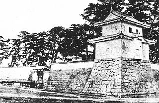
Himeji is a city located in Hyōgo Prefecture in the Kansai region of Japan. As of 1 June 2022, the city had an estimated population of 525,682 in 227,099 households and a population density of 980 persons per km2. The total area of the city is 534.35 square kilometres (206.31 sq mi).

<span class="mw-page-title-main">Aioi, Hyōgo</span> City in Kansai, Japan

Aioi is a city in Hyōgo Prefecture, Japan. As of 31 May 2022, the city had an estimated population of 28,208 in 13143 households and a population density of 310 persons per km2. The total area of the city is 90.4 square kilometres (34.9 sq mi).

<span class="mw-page-title-main">Tatsuno, Hyōgo</span> City in Kansai, Japan

Tatsuno is a city in Hyōgo Prefecture, Japan. As of 31 May 2022, the city had an estimated population of 74,414 in 31119 households and a population density of 6200 persons per km2. The total area of the city is 49.42 square kilometres (19.08 sq mi).

<span class="mw-page-title-main">Inaba Province</span> Former province of Japan

Inaba Province was a former province in the area that is today the eastern half of Tottori Prefecture in the San'in region of Japan. Inaba was bordered by Hōki, Mimasaka, Harima and Tajima Provinces. Its abbreviated form name was Inshū (因州). In terms of the Gokishichidō system, Inaba was one of the provinces of the San'indo circuit. Under the Engishiki classification system, Inaba was ranked as one of the 35 "superior countries" (上国) in terms of importance, and one of the "near countries" (近国) in terms of distance from the capital. The provincial capital was located in what is now the city of Tottori. The ichinomiya of the province is the Ube shrine also located in the city of Tottori.

<span class="mw-page-title-main">Chizu, Tottori</span> Town in Japan

Chizu is a town located in Yazu District, Tottori Prefecture, Japan. As of 1 January 2024, the town had an estimated population of 5,906 in 2681 households and a population density of 26.3 persons per km2. The total area of the town is 224.70 square kilometres (86.76 sq mi).

<span class="mw-page-title-main">Inami, Hyōgo</span> Town in Kansai, Japan

Inami is a town located in Kako District, Hyōgo Prefecture, Japan. As of 1 May 2022, the town had an estimated population of 30,622 in 12843 households and a population density of 880 persons per km². The total area of the town is 34.92 square kilometres (13.48 sq mi).

<span class="mw-page-title-main">Kamigōri, Hyōgo</span> Town in Kansai, Japan

Kamigōri is a town located in Akō District, Hyōgo Prefecture, Japan. As of 1 March 2022, the town had an estimated population of 14,179 in 6426 households and a population density of 94 persons per km². The total area of the town is 150.26 square kilometres (58.02 sq mi).

Kōzuki was a town located in Sayō District, Hyōgo Prefecture, Japan.

Nankō was a town located in Sayō District, Hyōgo Prefecture, Japan.

Mikazuki was a town located in Sayō District, Hyōgo Prefecture, Japan.

<span class="mw-page-title-main">Shisō, Hyōgo</span> City in Kansai, Japan

Shisō is a city in Hyōgo Prefecture, Japan. As of 31 May 2022, the city had an estimated population of 35,639 in 14694 households and a population density of 110 persons per km². The total area of the city is 658.54 square kilometres (254.26 sq mi).

<span class="mw-page-title-main">Tottori (city)</span> Core city in Chūgoku, Japan

Tottori is the capital and the largest city of Tottori Prefecture in the Chūgoku region of Japan. As of 30 November 2022, the city had an estimated population of 183,383 in 81,732 households and a population density of 240 persons per km². The total area of the city is 765.31 square kilometres (295.49 sq mi). Most of the city is within the San'in Kaigan Geopark.

<span class="mw-page-title-main">Yazu</span> Town in Chūgoku, Japan

Yazu is a town located in Yazu District, Tottori Prefecture, Japan. As of 30 November 2022, the town had an estimated population of 16,156 in 6140 households and a population density of 78 persons per km². The total area of the town is 206.71 square kilometres (79.81 sq mi).

<span class="mw-page-title-main">Akō Domain</span> Japanese feudal domain located in Harima Province

Akō Domain was a feudal domain under the Tokugawa shogunate of Edo period Japan, located in Harima Province in what is now the southwestern portion of modern-day Hyōgo Prefecture. It was centered around Akō Castle, which is located in what is now the city of Akō, Hyōgo.

<span class="mw-page-title-main">Hirafuku Station</span> Railway station in Sayō, Hyōgo Prefecture, Japan

Hirafuku Station is a passenger railway station located in the town of Sayō, Sayō District, Hyōgo Prefecture, Japan. It is operated by the third-sector semi-public railway operator Chizu Express.

<span class="mw-page-title-main">Kōzuki Station</span> Railway station in Sayō, Hyōgo Prefecture, Japan

Kōzuki Station is a passenger railway station located in the town of Sayō, Sayō District, Hyōgo Prefecture, Japan, operated by West Japan Railway Company.

<span class="mw-page-title-main">Inaba Kaidō</span> Road in Japan

The Inaba Kaidō (因幡街道) was a route built during the Edo period in Japan. It started in Himeji, Harima Province, and stretched to Tottori, Inaba Province. There were eleven post stations along the route connecting to two cities.

<span class="mw-page-title-main">Mikazuki Domain</span> Japanese feudal domain located in Harima Province

Mikazuki Domain was a feudal domain under the Tokugawa shogunate of Edo period Japan, in Harima Province in what is now the southwestern portion of modern-day Hyōgo Prefecture. It was centered around the Mikazuki jin'ya which was located in what is now the Mikazuki neighborhood of the town of Sayō, Hyōgo. It was controlled by a cadet branch tozama daimyō Mori clan throughout its history. It was also called Noino Domain.

<span class="mw-page-title-main">Yamasaki Domain</span> Japanese feudal domain located in Harima Province

Yamasaki Domain was a feudal domain under the Tokugawa shogunate of Edo period Japan, located in Harima Province in what is now the southwestern portion of modern-day Hyōgo Prefecture. It was centered around the Yamasaki jin'ya which was located in what is now the town of Yamasaki, Hyōgo. It was initially controlled by a cadet branch tozama daimyō Ikeda clan, but later came under the control of a cadet branch of the Honda clan. It was also called Shisō Domain

<span class="mw-page-title-main">Rikan Castle</span> Japanese castle

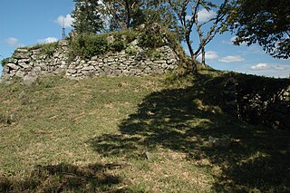
Rikan Castle was a Nanboku-chō to Sengoku period yamashiro-style Japanese castle located in the Hirafuku neighborhood of the town of Sayō, in far western Hyōgo Prefecture, Japan. The ruins have been protected as a National Historic Site since 2017.

References

  1. "Sayō town official statistics" (in Japanese). Japan.
  2. Sayō climate data
  3. Hyōgo population statistics