
Murakami is a city located in Niigata Prefecture, Japan. As of 1 December 2020, the city had an estimated population of 58,300 in 22,594 households, and a population density of 50 persons per km². The total area of the city was 1,174.26 square kilometres (453.38 sq mi).

Kawanishi is a city located in Hyōgo Prefecture, Japan. As of 30 September 2022, the city had an estimated population of 155,165 and a population density of 2900 persons per km². The total area of the city is 53.44 square kilometres (20.63 sq mi).
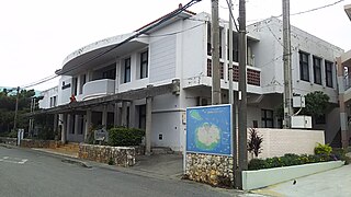
Tarama is a village located in Miyako District, Okinawa Prefecture, Japan. The village consists of Tarama Island and Minna Island between Ishigaki Island and Miyako Island.

Gero is a city located in Japan's Gifu Prefecture. As of 31 October 2017, the city had an estimated population of 33,283, and a population density of 39 persons per km2, in 12,253 households. The total area of the city was 851.21 square kilometres (328.65 sq mi). The city is famous for its hot springs.

Nichinan is a town located in Hino District, Tottori Prefecture, Japan. As of 31 December 2021, the town had an estimated population of 4,144 in 1903 households and a population density of 12 persons per km2. The total area of the town is 340.962 square kilometres (131.646 sq mi), representing 10% of the total area of Tottori Prefecture.Over 90% of the town is covered by mountains and forest, and 5% of the land is arable. Areas of Nichinan are part of Hiba-Dogo-Taishaku Quasi-National Park.

Kozagawa is a town located in Higashimuro District, Wakayama Prefecture, Japan. As of 1 November 2021, the town had an estimated population of 2,537 in 1415 households and a population density of 8.6 persons per km². The total area of the town is 294.23 square kilometres (113.60 sq mi). The total area of Kozagawa is the second largest in Wakayama Prefecture. However, the population of Kozagawa Town is the second smallest in the prefecture.

Toyono is a town situated in Toyono District, Osaka Prefecture, Japan. As of 31 March 2023, the town had an estimated population of 18,377 in 8675 households and a population density of 540 persons per km2. The total area of the town is 34.34 square kilometres (13.26 sq mi).

Kumatori is a town located in Sen'nan District, Osaka Prefecture, Japan. As of 31 December 2021, the town had an estimated population of 43,154 in 18377 households and a population density of 2500 persons per km2. The total area of the town is 17.24 square kilometres (6.66 sq mi).

Tajiri is a town located in Sennan District, Osaka Prefecture, Japan. As of 1 January 2022, the town had an estimated population of 8,492 in 4010 households and a population density of 1500 persons per km2. The total area of the town is 5.62 square kilometres (2.17 sq mi).

Minakami is a town located in Gunma Prefecture, Japan. As of 31 October 2020, the town had an estimated population of 18,383 in 7938 households, and a population density of 24 persons per km2. The total area of the town is 781.08 square kilometres (301.58 sq mi). Much of the town is within the borders of Jōshin'etsu-kōgen National Park.

Hinoemata is a village located in Fukushima Prefecture, Japan. As of 1 January 2020, the village had an estimated population of 556, and a population density of 1.5 persons per km². The total area of the village was 390.46 square kilometres (150.76 sq mi). It is locally famous for its soba and known nationally for its kabuki performances and as a gateway to the Oze marshlands.

Ōkura is a village in Yamagata Prefecture, Japan. As of January 2020, the village has an estimated population of 3044, and a population density of 14 persons per km2. The total area is 211.59 square kilometres (82 sq mi).

Higashidōri is a village located in Aomori, Japan. As of 31 January 2023, the village had an estimated population of 5,913 in 2829 households, and a population density of 20 persons per km². Its total area is 295.27 square kilometres (114.00 sq mi).

Otoineppu is a village located in Kamikawa Subprefecture, Hokkaido, Japan. As of 29 February 2024, the village had an estimated population of 607 among 411 households. The total area of Otoineppu is 275.64 square kilometres (106.43 sq mi). Otoineppu designates itself as the "smallest village in Hokkaido".

Kami is a town located in Mikata District, Hyōgo Prefecture, Japan. As of 31 March 2022, the town had an estimated population of 16,256 in 6368 households and a population density of 44 persons per km². The total area of the town is 368.77 square kilometres (142.38 sq mi). The Ojiro neighborhood of the town is designated as one of the Most Beautiful Villages in Japan. Kami is the birthplace of Tajiri-go, a Tajima Cattle who is the ancestor of more than 99.9% of Japanese Black wagyu.

Hachimantai is a city located in Iwate Prefecture, Japan. As of 1 April 2020, the city had an estimated population of 25,076, and a population density of 29 persons per km2 in 10,531 households. The total area of the city is 862.30 square kilometres (332.94 sq mi).

Miyoshi is a city located in Tokushima Prefecture, Japan. As of 30 June 2022, the city had an estimated population of 23,782 in 12103 households and a population density of 33 persons per km2. The total area of the city is 721.42 square kilometres (278.54 sq mi).
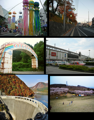
Ōsaki is a city located in Miyagi Prefecture, Japan. As of 1 May 2020, the city had an estimated population of 128,763 in 51,567 households, and a population density of 160 persons per km2. The total area of the city is 796.76 square kilometres (307.63 sq mi). Ōsaki is a member of the World Health Organization’s Alliance for Healthy Cities (AFHC).
Nantan is a city located in Kyoto Prefecture, Japan. As of 1 May 2022, the city had an estimated population of 30,744 in 14406 households and a population density of 50 persons per km2. The total area of the city is 616.40 square kilometres (237.99 sq mi).

Naka is a town located in Naka District, Tokushima Prefecture, Japan. As of 31 March 2022, the town had an estimated population of 7,597 in 3734 households and a population density of 11 persons per km2. The total area of the town is 694.98 square kilometres (268.33 sq mi).


