
East Sahuarita was a census-designated place (CDP) in Pima County, Arizona, United States. The population was 1,419 at the 2000 census. The CDP comprises the unincorporated neighborhoods east of incorporated Sahuarita.

Ak-Chin Village is a census-designated place (CDP) in Pinal County, Arizona, United States on the Ak-Chin (Maricopa) Reservation. The population was 862 at the 2010 census, up from 669 in 2000.

Fairmont is an unincorporated community and census-designated place (CDP) in Will County, Illinois, United States. The population was 2,389 at the 2020 census.
Alpine Northeast is a census-designated place in Lincoln County, Wyoming, United States. The population was 246 at the 2020 census.
Auburn is a census-designated place (CDP) in Lincoln County, Wyoming, United States. As of the 2020 census, the CDP population was 375.

Bedford is a census-designated place (CDP) in Lincoln County, Wyoming, United States. The population was 465 at the 2020 census.

Fairview (CDP) is in Lincoln County, Wyoming, United States. The population was 277 at the 2020 census.

Fontenelle is a census-designated place (CDP) in Lincoln County, Wyoming, United States. The population was 5 at the 2020 census. It is named after the hamlet of Fontenelle, which is located in the southeast corner of the roughly-rectangular CDP.

Grover is a census-designated place (CDP) in Lincoln County, Wyoming, United States. The population was 481 at the 2020 census.
Oakley is a census-designated place (CDP) in Lincoln County, Wyoming, United States. The population was 49 at the 2010 census.

Smoot is a census-designated place (CDP) in Lincoln County, Wyoming, United States. The population was 195 at the 2010 census.

Star Valley Ranch is a town in Lincoln County, Wyoming, United States. The population was 1,866 at the 2020 census. It was incorporated on November 8, 2005; at the 2000 census, it was only a census-designated place (CDP).

Turnerville is a census-designated place (CDP) in Lincoln County, Wyoming, United States. The population was 192 at the 2010 census.
Hartrandt is a census-designated place (CDP) in Natrona County, Wyoming, United States. It is part of the Casper, Wyoming Metropolitan Statistical Area and the population was 693 at the 2010 census.

Calpet is an unincorporated community in Sublette County, Wyoming, United States. The population was 7 at the 2000 census, when it was a census-designated place (CDP).

Daniel is a census-designated place in Sublette County, Wyoming, United States. The population was 150 at the 2010 census.
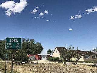
Eden is a census-designated place (CDP) in Sweetwater County, Wyoming, United States. The population was 281 at the 2010 census.
Farson is a census-designated place (CDP) in Sweetwater County, Wyoming, United States. The population was 313 at the 2010 census.

Teton Village is a census-designated place (CDP) in Teton County, Wyoming, United States. The population was 517 at the 2020 census. The village surrounds the base of the Jackson Hole Mountain Resort. It is accessed from nearby Jackson and the surrounding area via the Moose-Wilson Road.

Fort Bridger is a census-designated place (CDP) in eastern Uinta County, Wyoming, United States. The population was 354 at the 2020 census. The community takes its name from the eponymous Fort Bridger, established in 1842, which is located within the boundaries of the CDP.


