Thayne, Wyoming

Last updated

Thayne, Wyoming
Lincoln County Wyoming Incorporated and Unincorporated areas Thayne Highlighted 5676370.svg
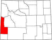
Location of Thayne in Lincoln County, Wyoming. The current Mayor is a Devin Simpson, he took office in 2019
Usa edcp location map.svg
Red pog.svg
Thayne, Wyoming
Location in the United States
Coordinates: 42°55′11″N111°0′3″W / 42.91972°N 111.00083°W / 42.91972; -111.00083
Country United States
State Wyoming
County Lincoln
Area
[1]
  Total1.48 sq mi (3.84 km2)
  Land1.48 sq mi (3.84 km2)
  Water0.00 sq mi (0.00 km2)
Elevation
5,906 ft (1,800 m)
Population
 (2010) [2]
  Total366
  Estimate 
(2019) [3]
394
  Density266.04/sq mi (102.72/km2)
Time zone UTC-7 (Mountain (MST))
  Summer (DST) UTC-6 (MDT)
ZIP code
83127
Area code 307
FIPS code 56-76370 [4]
GNIS feature ID1603591 [5]
Website www.thayne-wy.com

Thayne is a town in Lincoln County, Wyoming, United States. The population was 366 at the 2010 census.

Contents

Geography

Thayne is located at 42°55′11″N111°0′3″W / 42.91972°N 111.00083°W / 42.91972; -111.00083 (42.919754, –111.000714), [6] at 5906 feet in elevation. It sits in the northern portion of Wyoming's grassy Star Valley, close to the Salt River. Thayne is surrounded by green grassland and ranches, with forested mountains at the valley's edge.

According to the United States Census Bureau, the town has a total area of 1.39 square miles (3.60 km2), all land. [7]

Demographics

Historical population
CensusPop.Note
1950 229
1960 214−6.6%
1970 195−8.9%
1980 25631.3%
1990 2674.3%
2000 34127.7%
2010 3667.3%
2019 (est.)394 [3] 7.7%
U.S. Decennial Census [8]

2010 census

As of the census [2] of 2010, there were 366 people, 144 households, and 90 families living in the town. The population density was 263.3 inhabitants per square mile (101.7/km2). There were 171 housing units at an average density of 123.0 per square mile (47.5/km2). The racial makeup of the town was 91.5% White, 1.1% Asian, 6.0% from other races, and 1.4% from two or more races. Hispanic or Latino of any race were 9.3% of the population.

There were 144 households, of which 35.4% had children under the age of 18 living with them, 49.3% were married couples living together, 9.0% had a female householder with no husband present, 4.2% had a male householder with no wife present, and 37.5% were non-families. 31.9% of all households were made up of individuals, and 11.2% had someone living alone who was 65 years of age or older. The average household size was 2.54 and the average family size was 3.22.

The median age in the town was 35.6 years. 27.6% of residents were under the age of 18; 8.1% were between the ages of 18 and 24; 24.6% were from 25 to 44; 28.7% were from 45 to 64; and 10.9% were 65 years of age or older. The gender makeup of the town was 53.0% male and 47.0% female.

2000 census

As of the census [4] of 2000, there were 341 people, 118 households, and 86 families living in the town. The population density was 467.4 people per square mile (180.4/km2). There were 135 housing units at an average density of 185.0 per square mile (71.4/km2). The racial makeup of the town was 97.65% White, 0.29% Native American, 0.29% from other races, and 1.76% from two or more races. Hispanic or Latino of any race were 0.59% of the population.

There were 118 households, out of which 48.3% had children under the age of 18 living with them, 60.2% were married couples living together, 10.2% had a female householder with no husband present, and 26.3% were non-families. 19.5% of all households were made up of individuals, and 6.8% had someone living alone who was 65 years of age or older. The average household size was 2.89 and the average family size was 3.31.

In the town, the population was spread out, with 35.8% under the age of 18, 12.0% from 18 to 24, 25.8% from 25 to 44, 16.4% from 45 to 64, and 10.0% who were 65 years of age or older. The median age was 26 years. For every 100 females, there were 99.4 males. For every 100 females age 18 and over, there were 99.1 males.

The median income for a household in the town was $31,875, and the median income for a family was $30,250. Males had a median income of $31,406 versus $15,375 for females. The per capita income for the town was $10,248. About 24.7% of families and 27.4% of the population were below the poverty line, including 24.6% of those under age 18 and 26.5% of those age 65 or over.

Education

Public education in the town of Thayne is provided by Lincoln County School District #2.

Thayne has a public library, a branch of the Lincoln County Library System. [9]

Related Research Articles

<span class="mw-page-title-main">Platte County, Wyoming</span> County in Wyoming, United States

Platte County is a county located in the U.S. state of Wyoming. As of the 2020 United States Census, the population was 8,605. Its county seat is Wheatland.

<span class="mw-page-title-main">Lincoln County, Wyoming</span> County in Wyoming, United States

Lincoln County is a county in the U.S. state of Wyoming. As of the 2020 United States Census, the population was 19,581. Its county seat is Kemmerer. Its western border abuts the eastern borders of the states of Idaho and Utah.

<span class="mw-page-title-main">Saratoga, Wyoming</span> Town in Wyoming, United States

Saratoga is a town in Carbon County, Wyoming, United States. The population was 1,690 at the 2010 census.

<span class="mw-page-title-main">Montpelier, Idaho</span> City in Idaho, United States

Montpelier is a city in Bear Lake County, Idaho, United States. The population was 2,538 at the 2019 estimation, down from 2,597 in 2010 census. The city is the largest community in the Bear Lake Valley, a farming region north of Bear Lake in southeastern Idaho along the Utah border. It was settled in 1863 by Mormon pioneers on the route of the Oregon Trail. Nearby to the east is the border with Wyoming.

<span class="mw-page-title-main">Fairfax, Iowa</span> City in Iowa, United States

Fairfax is a city in Linn County, Iowa, United States. The population was 2,828 at the time of the 2020 census. It is part of the Cedar Rapids Metropolitan Statistical Area.

<span class="mw-page-title-main">Rosepine, Louisiana</span> Town in Louisiana, United States

Rosepine is a town in Vernon Parish, Louisiana, United States. The population was 1,692 at the 2010 census. It is part of the Fort Polk South Micropolitan Statistical Area.

<span class="mw-page-title-main">Hyannis, Nebraska</span> Village in and county seat of Hyannis County, Nebraska, United States

Hyannis is a village in Grant County, Nebraska, United States. The population was 165 at the time of the 2020 census. It is the county seat of Grant County. It is centrally located in the extensive, unique, and remote region of grasslands known as the Sandhills of Nebraska at the intersection of two Nebraska State Highways: NSH 61 which runs north and south, and NSH 2, which runs east and west.

<span class="mw-page-title-main">Gayville, South Dakota</span> Town in South Dakota, United States

Gayville is a town in Yankton County, South Dakota, United States. The population was 382 at the 2020 census.

<span class="mw-page-title-main">Lake Roesiger, Washington</span> CDP in Washington, United States

Lake Roesiger is a census-designated place (CDP) in Snohomish County, Washington, United States. The population was 503 at the 2010 census.

<span class="mw-page-title-main">Oceana, West Virginia</span> Town in West Virginia, United States

Oceana is a town in Wyoming County, West Virginia. The population was 1,462 at the time of the 2020 census. Oceana is the oldest city in Wyoming County and was the county seat until 1907. Oceana was the eponym of the film Oxyana. The town has a town hall and a local police department. It is home to the only McDonald's in Wyoming County.

<span class="mw-page-title-main">Wyoming, Waupaca County, Wisconsin</span> Town in Wisconsin, United States

Wyoming is a town in Waupaca County, Wisconsin, United States. The population was 285 at the 2000 census. The ghost town of Granite City was located in the town.

<span class="mw-page-title-main">Rock River, Wyoming</span> Town in Wyoming, United States

Rock River is a town in Albany County, Wyoming, United States. As of the 2010 census, the town population was 245.

<span class="mw-page-title-main">Dixon, Wyoming</span> Town in Wyoming, United States

Dixon is a town in Carbon County, Wyoming, United States. The population was 97 at the 2010 census.

<span class="mw-page-title-main">Fort Laramie, Wyoming</span> Town in Wyoming, United States

Fort Laramie is a town in Goshen County, Wyoming, United States. The population was 230 at the 2010 census. The town is named after historic Fort Laramie, an important stop on the Oregon, California and Mormon trails, as well as a staging point for various military excursions and treaty signings. The old fort was located south of town across the North Platte River, at the mouth of the Laramie River.

<span class="mw-page-title-main">Afton, Wyoming</span> Town in Wyoming, United States

Afton is a town in Lincoln County, Wyoming, United States. The population was 1,911 at the 2010 census.

<span class="mw-page-title-main">Edgerton, Wyoming</span> Town in Wyoming, United States

Edgerton is a town in Natrona County, Wyoming, United States. It is part of the Casper, Wyoming Metropolitan Statistical Area. The population was 195 at the 2010 census.

<span class="mw-page-title-main">Clearmont, Wyoming</span> Town in Wyoming, United States

Clearmont is a town in Sheridan County, Wyoming, United States. The population was 142 at the 2010 census.

<span class="mw-page-title-main">Dayton, Wyoming</span> Town in Wyoming, United States

Dayton is a town in Sheridan County, Wyoming, United States. The population was 822 at the 2020 census.

<span class="mw-page-title-main">Lyman, Wyoming</span> Town in Wyoming, United States

Lyman is a town in Uinta County, Wyoming, United States. The population was 2,115 at the 2010 census.

<span class="mw-page-title-main">Mountain View, Wyoming</span> Town in Wyoming, United States

Mountain View is a town in Uinta County, Wyoming, United States. The population was 1,286 at the 2010 census.

References

  1. "2019 U.S. Gazetteer Files". United States Census Bureau. Retrieved August 7, 2020.
  2. 1 2 "U.S. Census website". United States Census Bureau . Retrieved December 14, 2012.
  3. 1 2 "Population and Housing Unit Estimates". United States Census Bureau. May 24, 2020. Retrieved May 27, 2020.
  4. 1 2 "U.S. Census website". United States Census Bureau . Retrieved January 31, 2008.
  5. "US Board on Geographic Names". United States Geological Survey. October 25, 2007. Retrieved January 31, 2008.
  6. "US Gazetteer files: 2010, 2000, and 1990". United States Census Bureau. February 12, 2011. Retrieved April 23, 2011.
  7. "US Gazetteer files 2010". United States Census Bureau. Archived from the original on January 25, 2012. Retrieved December 14, 2012.
  8. "Census of Population and Housing". Census.gov. Retrieved June 4, 2015.
  9. "Wyoming Public Libraries". PublicLibraries.com. Retrieved June 13, 2019.