Teesta Low Dam - IV Hydropower Plant

Last updated
Teesta Low Dam - IV
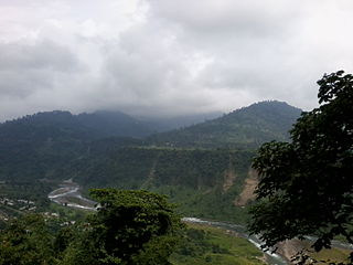
Lower Dam IV across Teesta River, AJTJ P1110110.jpg
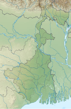
West Bengal relief map.svg
Red pog.svg
Location of Teesta Low Dam - IV in West Bengal
India relief location map.jpg
Red pog.svg
Teesta Low Dam - IV Hydropower Plant (India)
Official nameTeesta Low Dam - IV Hydropower Plant
CountryIndia
Location Kalimpong district, West Bengal
Coordinates 26°56′02″N88°26′49″E / 26.9339354°N 88.4470021°E / 26.9339354; 88.4470021 Coordinates: 26°56′02″N88°26′49″E / 26.9339354°N 88.4470021°E / 26.9339354; 88.4470021
PurposePower
StatusOperational
Opening date2016
Owner(s) NHPC
Dam and spillways
Impounds Teesta River
Height54 m (177 ft)
Length530 m (1,739 ft)
Power Station
Commission date2016 [1]
Type Run-of-the-river
Hydraulic head 25.05 m (82 ft) (gross)
Turbines 4 X 40 MW
Installed capacity 160 MW [1]
Annual generation 720 MU [1]

Teesta Low Dam - IV Hydropower Plant [2] is a run-of-the-river hydroelectric station built on the Teesta River.

Contents

Geography

Places in the Kalimpong Sadar subdivision in Kalimpong district
CT: census town, R: rural/ urban centre, M: municipality, F: facility, NP: national park
Abbreviations used in names – TG for Tea Garden (town/village)
Owing to space constraints in the small map, the actual locations in a larger map may vary slightly

Location

It is located in Kalimpong district, West Bengal, about 350 meters above the confluence of the Kalijora river Teesta River and in the 1.5 kilometer kiln of Teesta Bridge near Teesta Bazar village. 18.3 km downstream from the Teesta bridge near at Tista Bazar village. It is near Kalijhora, (see map alongside).

The project

The project consists of a 45 m high dam with 4 penstocks of 45 m length and 7 m diameter each. The surface power house with installed capacity of 160 MW houses 4 units of 40 MW capacity each designed to operate under the net rated head of 25.05 M and designed to generate 720 million units in a 90% dependable year with 95% machine availability. Unit I, II, III and IV were commissioned in the month of February, March, July and August 2016 [1] [3] respectively. The state of West Bengal is the sole beneficiary of this power station. With the construction of the project the area is also benefited by development infrastructure, education, medical facilities and employment avenues.

Related Research Articles

Mica Dam Dam in Mica Creek, British Columbia, Canada

Mica Dam, a hydroelectric embankment dam spanning the Columbia River 135 kilometres north of Revelstoke, British Columbia, Canada, was built as one of three Canadian projects under the terms of the 1964 Columbia River Treaty and is operated by BC Hydro. Completed in 1973 under the terms of the treaty, the Mica powerhouse had an original generating capacity of 1,805 megawatts (MW). Mica Dam, named after the nearby settlement of Mica Creek and its associated stream, in turn named after the abundance of mica minerals in the area, is one of the largest earthfill dams in the world. The reservoir for the dam is Kinbasket Lake, which was created when the dam was built. Water from the dam flows south directly into Revelstoke Lake, the reservoir for the Revelstoke Dam. Mica Dam is the tallest dam in Canada and second tallest in North America after the Chicoasén Dam in Mexico and it is the farthest upstream dam on the Columbia River. The dam's underground powerhouse was the second largest in the world at the time of its construction, and was the first 500 kV installation of sulphur hexafluoride (SF6) insulated switchgear in the world.

Teesta River River that flows from the eastern Himalayas to the Bay of Bengal

Teesta River is a 414 km (257 mi) long river that rises in the Pauhunri Mountain of eastern Himalayas, flows through the Indian states of Sikkim and West Bengal through Bangladesh and enters the Bay of Bengal. It drains an area of 12,540 km2 (4,840 sq mi). In India, it flows through North Sikkim, East Sikkim, Pakyong District, Kalimpong district, Darjeeling District, Jalpaiguri District, Cooch Behar districts and the cities of Rangpo, Jalpaiguri and Mekhliganj. It joins River Brahmaputra at Fulchhari in Bangladesh. 305 km (190 mi) portion of the river lies in India and rest in Bangladesh. Teesta is the largest river of Sikkim and second largest river of West Bengal after Ganges.

Mangla Dam Multipurpose dam in Azad Jammu and Kashmir, Pakistan

The Mangla Dam is a multipurpose dam situated on the Jhelum River in the Mirpur District of Azad Jammu and Kashmir, Pakistan. It is the sixth-largest dam in the world. The village of Mangla, which sits at the mouth of the dam, serves as its namesake. In November 1961, the project's selected contractors were revealed; it was announced that Binnie & Partners, a British engineering firm, was going to serve as the lead designers, engineers, and inspectors for the construction of the dam. The project was undertaken by a consortium known as the Mangla Dam Contractors, which consisted of eight American construction firms sponsored by the Guy F. Atkinson Company based in South San Francisco, California. It is a part of jehlum

Bhima River Major river in southwest India

The Bhima River is a major river in Western India and South India. It flows southeast for 861 kilometres (535 mi) through Maharashtra, Karnataka, and Telangana states, before entering the Krishna River. After the first sixty-five kilometers in a narrow valley through rugged terrain, the banks open up and form a fertile agricultural area which is densely populated.

Tarbela Dam Dam in Swabi, Khyber Pakhtunkhwa, Pakistan

Tarbela Dam is an earth-filled dam along the Indus River in Pakistan's Khyber Pakhtunkhwa province. Located in the Swabi mainly and in some area of Haripur District of the province, The dam is about 30 km (20 mi) from the city of Swabi, 105 km (65 mi) northwest of Islamabad, and 125 km (80 mi) east of Peshawar. It is the largest earth-filled dam in the world. The dam is 143 metres (470 ft) high above the riverbed and its reservoir, Tarbela Lake, has a surface area of approximately 250 square kilometres (97 sq mi).

The Balimela Reservoir is located in Malkangiri district, Odisha, India on the river Sileru which is a tributary of the Godavari river. The gross storage capacity of Balimela reservoir is 3610 million cubic meters.

Nagarjuna Sagar Dam Dam in Nalgonda district, Telangana

Nagarjuna Sagar Dam is a masonry dam across the Krishna River at Nagarjuna Sagar which straddles the border between Nalgonda district in Telangana and Guntur district in Andhra Pradesh. The dam provides irrigation water to the Nalgonda, Suryapet, Krishna, Khammam, West Godavari, Guntur, and Prakasam districts along with electricity generation.

Rangpo River

River Rangpo is a river in the Indian state of Sikkim. A tributary of the Teesta River, it originates from Menmecho Lake and flows through Rongli and Pakyong subdivision villages in Pakyong District towards Rorathang and Rangpo. The river demarcates the border between Pakyong District of Sikkim and Kalimpong district of West Bengal from Rorathang to Rangpo. At the town of Rangpo the river joins river Teesta. River Rangpo is the third largest river of Sikkim after Teesta and Rangeet.

Damodar Valley Corporation

Damodar Valley Corporation (DVC) is an Indian governmental organization which operates in the Damodar River area of West Bengal and Jharkhand states of India. The corporation operates both thermal power stations and hydel power stations under the Ministry of Power, Govt of India. DVC is headquartered in the Kolkata city of West Bengal, India.

Barakar River

The Barakar River is the main tributary of the Damodar River in eastern India. Originating near Padma in Hazaribagh district of Jharkhand it flows for 225 kilometres (140 mi) across the northern part of the Chota Nagpur Plateau, mostly in a west to east direction, before joining the Damodar near Dishergarh in Asansol, Bardhaman district of West Bengal. It has a catchment area of 6,159 square kilometres (2,378 sq mi). The main tributaries, Barsoti and Usri, flow in from the south and north respectively. Apart from the two main tributaries some fifteen medium or small streams join it.

According to the International Hydropower Association, Canada is the world's fourth largest producer of hydroelectricity in the world in 2020 after the United States, Brazil, and China. In 2014, Canada consumed the equivalent of 85.7 megatonnes worth of oil of hydroelectricity, 9.8% of worldwide hydroelectric consumption. Furthermore, hydroelectricity accounted for 25.7% of Canada's total energy consumption. It is the third-most consumed energy in Canada behind oil and natural gas.

Kenya Electricity Generating Company State-owned electric power production company

Kenya Electricity Generating Company or simply KenGen is a parastatal company, and is the largest electric power producer in Kenya producing over 65% of the electricity consumed in the country.

Pykara

Pykara is river 19 kilometres (12 mi) from Ooty in the Indian State of Tamil Nadu with a village by the same name nearby. The Pykara River is considered very sacred by the Todas. It rises at Mukurthi peak, flows northwards, and then turns to the west after reaching the edge of the plateau. The river flows through Murkurti, Pykara and Glenmorgan dams, and forms part of an important hydro-electric power project.

Rangit Dam Dam in Legship, Sikkim, India

Rangit Dam, which forms the headworks of the Rangit Hydroelectric Power Project Stage III, is a run-of-the-river power project on the Ranjit River, a major tributary of the Tista River in the South Sikkim district of the Northeastern Indian state of Sikkim. The project's construction was completed in 1999. The project is fully functional since 2000. The project was built at a cost of Rs 4922.6 million. The average annual power generation from the 60 MW project is 340 GWh with firm power of 39 MW.

Kalimpong I Community development block in West Bengal, India

Kalimpong I is a community development block that forms an administrative division in the Kalimpong subdivision of the Kalimpong district in the Indian state of West Bengal.

Koyna Hydroelectric Project

The Koyna Hydroelectric Project is the second largest hydroelectric power plant in India, just after Tehri Dam Project. It is a complex project with four dams including the largest dam on the Koyna River, Maharashtra hence the name Koyna Hydroelectric Project. The project site is in Satara district.

Duber Khwar Hydroelectric Plant Dam in Pattan, Kohistan, KPK, Pakistan

Duber Khwar Hydropower Plant is located near the town of Pattan in Kohistan, Khyber Pakhtunkhwa, Pakistan on the Duber Khwar River, a right bank tributary of Indus River. It is approximately 300 km NW from Islamabad, the federal capital of Islamic Republic of Pakistan.

Teesta Low Dam - III Hydropower Plant Dam in Kalimpong district, West Bengal

Teesta Low Dam - III Hydropower Plant is a run-of-the-river hydroelectric station built on the Teesta River.

Rambi Bazar Urban Village in West Bengal, India

Rambi Bazar is an urban village in the Kalimpong I CD block in the Kalimpong Sadar subdivision of the Kalimpong district in the state of West Bengal, India. The town lies on the National Highway 10 connecting Siliguri and Gangtok.
Kalijhora Village in West Bengal, India

Kalijhora is a village in the Kalimpong I CD block that lies on the bank of River Teesta, in the Kalimpong Sadar subdivision of the Kalimpong district in the state of West Bengal, India. National Highway 10 connecting Siliguri and Gangtok passes through Kalijhora.
References

  1. 1 2 3 4 "NHPC completes Teesta Low Dam-IV hydro project". 19 August 2016. Retrieved 31 January 2020.
  2. "Teesta Low Dam - IV". nhpcindia.com. Retrieved 31 January 2020.
  3. "BHEL starts 40-mw hydro power unit in West Bengal". The Economic Times. Retrieved 31 January 2020.