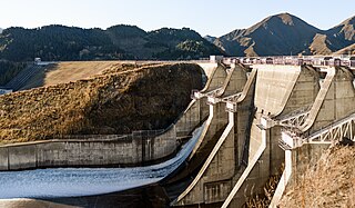
Benmore Dam is the largest dam within the Waitaki power scheme, located in the Canterbury Region of New Zealand's South Island. There are eight other power stations in the Waitaki Power Scheme.
Meridian Energy Limited is a New Zealand electricity generator and retailer. The company generates the largest proportion of New Zealand's electricity, generating 35 percent of the country's electricity in the year ending December 2014, and is the fourth largest retailer, with 14 percent of market share in terms of customers as of December 2015.

Manapōuri Power Station is an underground hydroelectric power station on the western arm of Lake Manapouri in Fiordland National Park, in the South Island of New Zealand. At 854 MW installed capacity, it is the largest hydroelectric power station in New Zealand, and the second largest power station in New Zealand. The station is noted for the controversy and environmental protests by the Save Manapouri Campaign against raising the level of Lake Manapouri to increase the station's hydraulic head, which galvanised New Zealanders and was one of the foundations of the New Zealand environmental movement.

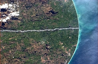
The Waitaki River is a large braided river in the South Island of New Zealand. It drains the Mackenzie Basin and runs 209 kilometres (130 mi) south-east to enter the Pacific Ocean between Timaru and Oamaru on the east coast. It starts at the confluence of the Ōhau and Tekapo rivers, now at the head of the artificial Lake Benmore, these rivers being fed by three large glacial lakes, Pukaki, Tekapo, and Ōhau at the base of the Southern Alps. The Waitaki flows through Lake Benmore, Lake Aviemore and Lake Waitaki, these lakes being contained by hydroelectric dams, Benmore Dam, Aviemore Dam and Waitaki Dam. The Waitaki has several tributaries, notably the Ahuriri River and the Hakataramea River. It passes Kurow and Glenavy before entering the Pacific Ocean. The River lends its name the Waitaki District on the south side of the river bank.

Twizel is the largest town in the Mackenzie District, in the Canterbury Region of the South Island of New Zealand. The town was founded in 1968 to house construction workers on the Upper Waitaki Hydroelectric Scheme. Today, Twizel is a service and tourist town for visitors to the area. It has a resident population of 1,890 ; during the summer, holidaymakers nearly triple the town's population.

Lake Benmore is New Zealand's largest artificial lake. Located in the South Island of New Zealand and part of the Waitaki River, it was created in the 1960s by construction of Benmore Dam.

Lake Pukaki is the largest of three roughly parallel alpine lakes running north–south along the northern edge of the Mackenzie Basin on New Zealand's South Island. The others are Lakes Tekapo and Ōhau. All three lakes were formed when the terminal moraines of receding glaciers blocked their respective valleys, forming moraine-dammed lakes. The Alps2Ocean mountain bike trail follows the edge of Lake Pukaki for part of its length.

Lake Tekapo is the second-largest of three roughly parallel lakes running north–south along the northern edge of the Mackenzie Basin in the South Island of New Zealand. It covers an area of 83 km2 (32 sq mi) and is at an altitude of 710 m (2,330 ft) above sea level.

The Pukaki River flows through the Mackenzie Basin, Canterbury, in New Zealand's South Island.
Project Aqua was a hydroelectric scheme proposed for the lower Waitaki River in New Zealand. Although the scheme had considerable support from some locals, it met with opposition from many other groups, and Meridian Energy decided in March 2004 not to go ahead with the project.

The Aviemore Dam is a dam on the Waitaki River in New Zealand. The dam is a composite dam, with an embankment section, and a concrete section. Built in the 1960s it impounds Lake Aviemore.

Hydroelectric power in New Zealand has been a part of the country's energy system for over 100 years and continues to provide more than half of the country's electricity needs. Hydroelectricity is the primary source of renewable energy in New Zealand. Power is generated the most in the South Island and is used most in the North Island.

The Coleridge Power Station is a hydroelectric facility at Lake Coleridge on the Rakaia River in Canterbury, New Zealand. The power station is owned and operated by Manawa Energy.
The North Bank tunnel concept was a hydroelectric scheme being developed by Meridian Energy on the Waitaki River in Canterbury, New Zealand. The $993 million project was expected to produce an additional 1,100 to 1,400 gigawatt-hours per annum, and take up to 260 cubic metres per second (9,200 cu ft/s) of water from Lake Waitaki. The project would have resulted in a 275 gigawatt-hours (990 TJ) per annum reduction in output from the Waitaki hydro station.

The Tongariro Power Scheme is a 360 MW hydroelectricity scheme in the central North Island of New Zealand. The scheme diverts water from tributaries of the Rangitikei, Whangaehu, Whanganui, and Tongariro rivers. These rivers drain a 2,600-square-kilometre (1,000 sq mi) area including Ruapehu, Ngauruhoe, Tongariro and the western Kaimanawa Ranges. The water diverted from these rivers is sent through canals and tunnels to generate electricity at three hydro power stations, Rangipo (120 MW), Tokaanu (240 MW) and Mangaio (2 MW). The water is then discharged into Lake Taupō where it adds to the water storage in the lake and enables additional electricity generation in the succession of power stations down the Waikato River.

Maraetai Power Station is a hydroelectric power station on the Waikato River, in the North Island of New Zealand. It is the fifth of the eight hydroelectric power stations on the Waikato River, and at 360 MW, is the largest hydroelectric station on the Waikato.
The Mangorei Power Station is a hydroelectric power facility near Mangorei in Taranaki in New Zealand which makes use of water from the Waiwhakaiho River and the Mangamahoe Stream catchments.

The Waitaki Dam is one of eight hydroelectric power stations which form the Waitaki hydroelectric scheme on the Waitaki River in the Canterbury Region of New Zealand. The dam was the first of three to be built on the Waitaki River and was constructed without earthmoving machinery; over half a million cubic metres of material was excavated, almost entirely by pick-and-shovel. The Waitaki Dam's construction was followed by the development of Aviemore Dam and Benmore Dam, and importantly, every dam built in New Zealand since the Waitaki has benefited from lessons learned during its construction.


