Tenmile Creek (West Fork River)

Last updated
Tenmile Creek
Tenmile Creek Lumberport.jpg
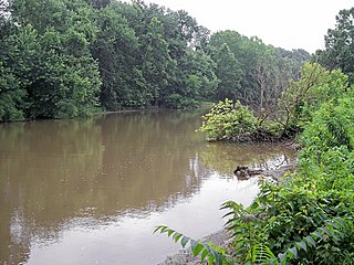
Tenmile Creek in Lumberport in 2006
Country United States
State West Virginia
County Harrison County
Source
 - locationsouthwestern Harrison County
 - elevation1,289 ft (393 m) [1]
 - coordinates 39°12′17″N80°31′36″W / 39.20472°N 80.52667°W / 39.20472; -80.52667   [2]
Mouth West Fork River
 - location Lumberport
 - elevation892 ft (272 m) [2]
 - coordinates 39°22′39″N80°20′21″W / 39.37750°N 80.33917°W / 39.37750; -80.33917 Coordinates: 39°22′39″N80°20′21″W / 39.37750°N 80.33917°W / 39.37750; -80.33917   [2]
Length26.4 mi (42 km)
Basin126 sq mi (326 km2)
USA West Virginia location map.svg
Red pog.svg
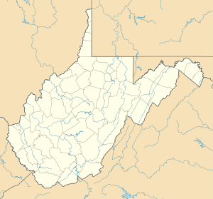
Location of the mouth of Tenmile Creek in Lumberport, West Virginia

Tenmile Creek is a tributary of the West Fork River, 26.4 miles (42.5 km) long, [3] in north-central West Virginia in the United States. Via the West Fork, Monongahela and Ohio Rivers, it is part of the watershed of the Mississippi River, draining an area of 126 square miles (330 km2) [4] on the unglaciated portion of the Allegheny Plateau.

Tributary stream or river that flows into a main stem river or lake

A tributary or affluent is a stream or river that flows into a larger stream or main stem river or a lake. A tributary does not flow directly into a sea or ocean. Tributaries and the main stem river drain the surrounding drainage basin of its surface water and groundwater, leading the water out into an ocean.

West Fork River river in the United States of America

The West Fork River is a principal tributary of the Monongahela River, 103 miles (166 km) long, in north-central West Virginia in the United States. Via the Monongahela and Ohio Rivers, it is part of the watershed of the Mississippi River, draining an area of 881 square miles (2,284 km²) on the unglaciated portion of the Allegheny Plateau.

West Virginia State of the United States of America

West Virginia is a state located in the Appalachian region in the Southern United States and is also considered to be a part of the Middle Atlantic States. It is bordered by Pennsylvania to the north, Maryland to the east and northeast, Virginia to the southeast, Kentucky to the southwest, and Ohio to the northwest. West Virginia is the 41st largest state by area, and is ranked 38th in population. The capital and largest city is Charleston.

Tenmile Creek and its watershed are located entirely in western and northern Harrison County. It rises in the southwestern part of the county, approximately 8 miles (13 km) west of West Milford, and flows northwardly and northeastwardly to the town of Lumberport, where it joins the West Fork River from the southwest. [5] Its tributaries include Salem Fork, [6] which drains the city of Salem; and Little Tenmile Creek, [7] 13 miles (21 km) long, [3] which flows southeastwardly through northwestern Harrison County and the small communities of Wallace, Brown, Dola, and Rosebud. [5]

Harrison County, West Virginia county in West Virginia, United States

Harrison County is a county in the U.S. state of West Virginia. As of the 2010 census, the population was 69,099. The county seat is Clarksburg. The county was founded in 1784.

West Milford, West Virginia Town in West Virginia, United States

West Milford is a town in Harrison County, West Virginia, United States. The population was 630 at the 2010 census.

Lumberport, West Virginia Town in West Virginia, United States

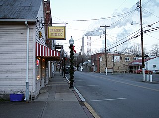
Lumberport is a town in Harrison County, located in northern West Virginia, United States. The population was 876 at the 2010 census.

According to the West Virginia Department of Environmental Protection, approximately 81% of Tenmile Creek's watershed is forested, mostly deciduous. Approximately 13% is used for pasture and agriculture, and less than 1% is urban. [4]

Forest dense collection of trees covering a relatively large area

A forest is a large area dominated by trees. Hundreds of more precise definitions of forest are used throughout the world, incorporating factors such as tree density, tree height, land use, legal standing and ecological function. According to the widely used Food and Agriculture Organization definition, forests covered 4 billion hectares (9.9×10⁹ acres) (15 million square miles) or approximately 30 percent of the world's land area in 2006.

Deciduous trees or shrubs that lose their leaves seasonally

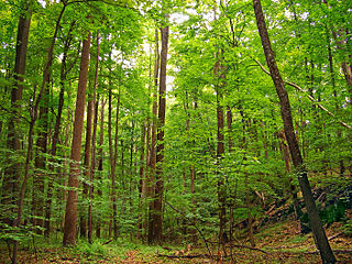
In the fields of horticulture and botany, the term deciduous (/dɪˈsɪdʒuəs/) means "falling off at maturity" and "tending to fall off", in reference to trees and shrubs that seasonally shed leaves, usually in the autumn; to the shedding of petals, after flowering; and to the shedding of ripe fruit.

According to the Geographic Names Information System, Tenmile Creek has also been known historically as Coal Bank Creek. [2]

Geographic Names Information System geographical database

The Geographic Names Information System (GNIS) is a database that contains name and locative information about more than two million physical and cultural features located throughout the United States of America and its territories. It is a type of gazetteer. GNIS was developed by the United States Geological Survey in cooperation with the United States Board on Geographic Names (BGN) to promote the standardization of feature names.

See also

Fletcher Covered Bridge West Virginia place listed on National Register of Historic Places

The Fletcher Covered Bridge is a 62-foot (19 m) Multiple King Post covered bridge located near Marshville in Harrison County, West Virginia. The bridge crosses Tenmile Creek is West Virginia bridge number 48-17-03. Stones for the abutments were quarried at the top of a hill near the bridge site. The original building cost was $1,372. The Fletcher Covered Bridge is one of only two covered bridges still standing in Harrison County, the other is the Simpson Creek Covered Bridge. This bridge is in regular use today.

Related Research Articles

Laurel Fork (Cheat River tributary) river in the United States of America

Laurel Fork is a 37.8-mile-long (60.8 km) river in eastern West Virginia, USA. It is a tributary of the Dry Fork; via the Dry Fork, the Black Fork, and the Cheat, Monongahela and Ohio rivers, it is part of the watershed of the Mississippi River, draining an area of 60 square miles (160 km2) in the Allegheny Mountains. With the Dry Fork, the Glady Fork, the Shavers Fork and the Blackwater River, it is considered to be one of the five principal headwaters tributaries of the Cheat River.

Stonecoal Creek river in the United States of America

Stonecoal Creek is a tributary of the West Fork River, 12.8 miles (20.6 km) long, in north-central West Virginia in the United States. Via the West Fork, Monongahela and Ohio Rivers, it is part of the watershed of the Mississippi River, draining an area of 41 square miles (110 km2) on the unglaciated portion of the Allegheny Plateau. The stream is believed to have been named in the late 1760s by a group of explorers and settlers, who found coal in nearby hills and mixed with pebbles in the stream.

Hackers Creek river in the United States of America

Hackers Creek is a tributary of the West Fork River, 25.4 miles (40.9 km) long, in north-central West Virginia in the United States. Via the West Fork, Monongahela and Ohio Rivers, it is part of the watershed of the Mississippi River, draining an area of 58 square miles (150 km2) on the unglaciated portion of the Allegheny Plateau. The stream is believed to have been named for a settler named John Hacker (1743-1824), who lived near the creek for over twenty years beginning around 1770, and was said to have been able to "read but not write; and yet he was a magistrate and a patriarch in the settlement."

Elk Creek (West Virginia) river in West Virginia

Elk Creek is a tributary of the West Fork River, 29 miles (47 km) long, in north-central West Virginia, USA. Via the West Fork, Monongahela and Ohio Rivers, it is part of the watershed of the Mississippi River, draining an area of 121 square miles (310 km2) on the unglaciated portion of the Allegheny Plateau. The stream is believed to have been named by an 18th-century trapper and hunter named John Simpson, who encountered herds of elk along the stream.

Wheeling Creek (West Virginia)

Wheeling Creek is a tributary of the Ohio River, 25 miles (40 km) long, in the Northern Panhandle of West Virginia in the United States, with a watershed extending into southwestern Pennsylvania. Via the Ohio River, it is part of the watershed of the Mississippi River, draining an area of approximately 300 square miles (780 km2) on the unglaciated portion of the Allegheny Plateau. It flows into the Ohio River in downtown Wheeling, just downstream of Ohio's Wheeling Creek on the opposite bank. A variant name is Big Wheeling Creek.

Mill Creek (western West Virginia) tributary of the Ohio River in western West Virginia, USA

Mill Creek is a tributary of the Ohio River, 29.4 miles (47.3 km) long, in western West Virginia in the United States. Via the Ohio, it is part of the watershed of the Mississippi River, draining an area of 234 square miles (610 km2) on the unglaciated portion of the Allegheny Plateau. According to the Geographic Names Information System, it has also been known historically as Big Mill Creek.

Sandy Creek (Ohio River) creek in Ravenswood, West Virginia

Sandy Creek is a tributary of the Ohio River in western West Virginia in the United States. Via the Ohio River, it is part of the watershed of the Mississippi River, draining an area of 124 square miles (320 km2) on the unglaciated portion of the Allegheny Plateau. The creek is 22 miles (35 km) long, or 38.3 miles (61.6 km) including its Left Fork.

Holly River river in the United States of America

The Holly River is a tributary of the Elk River in central West Virginia in the United States. Via the Elk, Kanawha, and Ohio Rivers, it is part of the watershed of the Mississippi River, draining an area of 148 square miles (380 km2) in a rural region of the Allegheny Mountains. It is approximately 3.9 miles (6.3 km) long, or 28 miles (45 km) including its Left Fork. The river was named for the holly bushes along its course.

Spring Creek (Little Kanawha River) tributary of the Little Kanawha River in western West Virginia

Spring Creek is a tributary of the Little Kanawha River in western West Virginia in the United States. Via the Little Kanawha and Ohio rivers, it is part of the watershed of the Mississippi River, draining an area of 89 square miles (230 km2) in a rural region on the unglaciated portion of the Allegheny Plateau. It is 25.3 miles (40.7 km) long, or 33.3 miles (53.6 km) long including its Left Fork.

Steer Creek (West Virginia) river in the United States of America

Steer Creek is a tributary of the Little Kanawha River in central West Virginia in the United States. Via the Little Kanawha and Ohio rivers, it is part of the watershed of the Mississippi River, draining an area of 184 square miles (480 km2) in a rural region on the unglaciated portion of the Allegheny Plateau. It is 6.3 miles (10.1 km) long, or 31.7 miles (51.0 km) long including its Right Fork.

Reedy Creek (West Virginia) river in the United States of America

Reedy Creek is a tributary of the Little Kanawha River in western West Virginia in the United States. Via the Little Kanawha and Ohio rivers, it is part of the watershed of the Mississippi River, draining an area of 133 square miles (340 km2) in a rural region on the unglaciated portion of the Allegheny Plateau. It is 22.6 miles (36.4 km) long, or 38.5 miles (62.0 km) long including its Left Fork.

Sand Fork (Little Kanawha River) river in the United States of America

The Sand Fork is a tributary of the Little Kanawha River, 18.7 miles (30.1 km) long, in central West Virginia in the United States. Via the Little Kanawha and Ohio Rivers, it is part of the watershed of the Mississippi River, draining an area of 80 square miles (210 km2) in a rural region on the unglaciated portion of the Allegheny Plateau.

Saltlick Creek (Little Kanawha River) river in the United States of America

Saltlick Creek is a tributary of the Little Kanawha River, 17.7 miles (28.5 km) long, in central West Virginia in the United States. Via the Little Kanawha and Ohio rivers, it is part of the watershed of the Mississippi River, draining an area of 49 square miles (130 km2) in a rural region on the unglaciated portion of the Allegheny Plateau.

Clear Fork (Guyandotte River tributary) river in the United States of America

The Clear Fork is a tributary of the Guyandotte River, 29 miles (47 km) long, in southern West Virginia in the United States. Via the Guyandotte and Ohio rivers, it is part of the watershed of the Mississippi River, draining an area of 129 square miles (330 km2) in a rural area on the unglaciated portion of the Allegheny Plateau. The Clear Fork flows for its entire length in Wyoming County; its tributary the Laurel Fork also drains a small area of western Raleigh County.

Laurel Fork (Clear Fork Guyandotte River tributary) river in the United States of America

The Laurel Fork is a tributary of the Clear Fork, 23.5 miles (37.8 km) long, in southern West Virginia in the United States. Via the Clear Fork and the Guyandotte and Ohio rivers, it is part of the watershed of the Mississippi River, draining an area of 56.4 square miles (146 km2) in a rural area on the unglaciated portion of the Allegheny Plateau.

Armstrong Creek (West Virginia) river in the United States of America

Armstrong Creek is a tributary of the Kanawha River, 8.6 miles (13.8 km) long, in southern West Virginia in the United States. Via the Kanawha and Ohio rivers, it is part of the watershed of the Mississippi River, draining an area of 22.8 square miles (59 km2) on the unglaciated portion of the Allegheny Plateau. The creek flows for its entire length in western Fayette County; its tributaries additionally drain a small portion of eastern Kanawha County.

Twomile Creek (Kanawha River) river in the United States of America

Twomile Creek is a tributary of the Kanawha River, 4.7 miles (7.6 km) long, in West Virginia in the United States. Via the Kanawha and Ohio rivers, it is part of the watershed of the Mississippi River, draining an area of 24.4 square miles (63 km2) on the unglaciated portion of the Allegheny Plateau, in the city of Charleston and its vicinity.

Buckeye Creek (West Virginia) river in the United States of America

Buckeye Creek is a tributary of Middle Island Creek, 12.7 miles (20.4 km) long, in north-central West Virginia in the United States. Via Middle Island Creek and the Ohio River, it is part of the watershed of the Mississippi River, draining an area of 39.1 square miles (101 km2) in a rural region on the unglaciated portion of the Allegheny Plateau.

McElroy Creek river in the United States of America

McElroy Creek is a tributary of Middle Island Creek, 22.1 miles (35.6 km) long, in northern West Virginia in the United States. Via Middle Island Creek and the Ohio River, it is part of the watershed of the Mississippi River, draining an area of 106.2 square miles (275 km2) in a rural region on the unglaciated portion of the Allegheny Plateau.

References

  1. Google Earth elevation for GNIS source coordinates. Retrieved on 2007-02-12.
  2. 1 2 3 4 Geographic Names Information System. "Geographic Names Information System entry for Tenmile Creek (Feature ID #1547966)" . Retrieved 2007-02-19.
  3. 1 2 United States Environmental Protection Agency. "Watershed Assessment, Tracking & Environmental Results: Assessment Summary for Reporting Year 2008, West Virginia, West Fork Watershed". Archived from the original on 2011-10-13. Retrieved 2011-10-13.
  4. 1 2 West Virginia Department of Environmental Protection. "Watershed Atlas Project". pp.  West Fork River watershed (cited figures are for Tenmile Creek and Salem Fork). Archived from the original on 2005-04-04. Retrieved 2007-02-26.
  5. 1 2 DeLorme (1997). West Virginia Atlas & Gazetteer. Yarmouth, Maine: DeLorme. ISBN   0-89933-246-3.
  6. Geographic Names Information System. "Geographic Names Information System entry for Salem Fork (Feature ID #1546293)" . Retrieved 2007-02-19.
  7. Geographic Names Information System. "Geographic Names Information System entry for Little Tenmile Creek (Feature ID #1542237)" . Retrieved 2007-02-19.