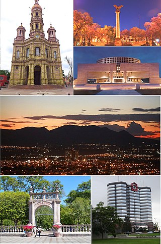
Aguascalientes is the capital of the Mexican state of the same name and its most populous city, as well as the head of the Aguascalientes Municipality; with a population of 948,990 inhabitants in 2012 and 1,225,432 in the metro area. The metropolitan area also includes the municipalities of Jesús María and San Francisco de los Romo. It is located in North-Central Mexico, which roughly corresponds to the Bajío region within the central Mexican plateau. The city stands on a valley of steppe climate at 1880 meters above sea level, at 21°51′N102°18′W.

Torreón is a city and seat of Torreón Municipality in the Mexican state of Coahuila. As of 2021, the city's population was 735,340. The metropolitan population as of 2015 was 1,497,734, making it the ninth-biggest metropolitan area in the country and the largest metropolitan area in the state of Coahuila, as well as one of Mexico's most important economic and industrial centers. The cities of Torreón; Gómez Palacio, Durango; Lerdo, Durango; Matamoros; Francisco I. Madero; San Pedro; Bermejillo, Durango; and Tlahualilo, Durango form the area of La Laguna or the Comarca Lagunera, a basin within the Chihuahuan Desert.

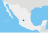
Aguascalientes, officially the Free and Sovereign State of Aguascalientes, is one of the 32 states which comprise the Federal Entities of Mexico. At 22°N and with an average altitude of 1,950 m (6,400 ft) above sea level it is predominantly of semi-arid climate. The state is located in the northern part of the Bajío region, which is in the north-central part of the country, bordered by Zacatecas to the north, east and west, and by Jalisco to the south.

Universidad is a station on the Mexico City Metro. It is located in the southern reaches of Mexico City, in Coyoacán borough. A surface station, it is the current terminus of Line 3. The station was opened on 30 August 1983. In 2021, the station had an average ridership of 25,858 passengers per day, making it the fifteenth busiest station in the network.

The Palacio de la Autonomía is a museum and site where the Universidad Nacional Autónoma de México gained autonomy from direct government control in 1929. The building is from the late 19th century, and located on the corner of Licenciado de Verdad and Rep de Guatemala streets, north of Santa Teresa la Antigua and east of Templo Mayor. The site has a 500-year history, starting from part of lands granted by Hernán Cortés. The current building was constructed by the administration of President Porfirio Díaz, but it was ceded to the university in 1910. Since that time, the building has had a number of uses, including housing a dental school and a preparatory school. Today it houses the Museo de la Autonomía Universitaria.
The following is a timeline of the history of the city of Guadalajara, Mexico.
The following is a timeline of the history of the city of Monterrey, Nuevo León, Mexico.
The following is a timeline of the history of the city of Guanajuato, Mexico.
The following is a timeline of the history of the city of Chihuahua, Mexico.
The following is a timeline of the history of the city of Mérida, Yucatán, Mexico.
The following is a timeline of the history of the city of Puebla, Mexico.
José Manuel Zacarías Gómez Valdés was a 19th-century Mexican lawyer and politician who served as interim governor of Nuevo León (1866–1867), senator, and congressman in the Chamber of Deputies representing the states of Nuevo León and Tamaulipas.
The following is a timeline of the history of the city of Ciudad Juárez, Chihuahua, Mexico.
The following is a timeline of the history of the city of León, Guanajuato, Mexico.
The following is a timeline of the history of the city of Villahermosa in Centro Municipality, Tabasco state, Mexico.
The following is a timeline of the history of the city of Campeche, Mexico.
Teresa del Conde Pontones was a Mexican art critic and art historian.
The following is a timeline of the history of the city of Acapulco de Juárez, Guerrero, Mexico.

José Refugio Reyes Rivas was a Mexican architect, author of some of the most representative buildings of the city of Aguascalientes, where his work is considered part of the historical and architectural heritage. Reyes did not have professional architectural studies, so he is called "empirical architect". In 1985 he received the post mortem title of architect, granted by the Autonomous University of Aguascalientes. Reyes completed more than 200 buildings in the states of Zacatecas, Jalisco and Aguascalientes. He was characterized by his use of diverse decorative styles, from neoclassical to Art Nouveau, as well as construction innovations of the first half of the 20th century.