
Tioga County is a county in the U.S. state of New York. As of the 2020 census, the population was 48,455. Its county seat is Owego. Tioga County is part of the Binghamton metropolitan area. The county is part of the Southern Tier region of the state.
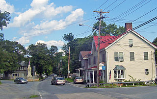
Apalachin is a census-designated place within the Town of Owego in Tioga County, New York, United States. The population was 1,131 in the 2010 census. The CDP is named after Apalachin Creek.
Richford is a town in Tioga County, New York, United States. The population was 1,043 at the 2020 census. The town is named after Ezekial Rich, an early settler and benefactor of the town.
Tioga is a town in Tioga County, New York, United States. The population was 4,455 at the 2020 census. The town is in the southwestern part of the county and lies between Elmira and Binghamton. Tioga is situated in the Southern Tier District of New York.

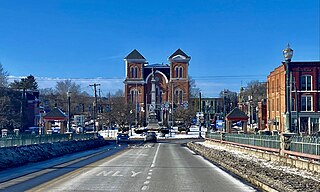
Owego is a village in and the county seat of Tioga County, New York, United States. The population was 3,896 at the 2010 census. It is part of the Binghamton Metropolitan Statistical Area. The name is derived from the Iroquois word Ahwaga, meaning where the valley widens.
Owego is a town in Tioga County, New York, United States. The population was 18,728 at the 2020 census. The name is derived from the Iroquois word Ahwaga, meaning "where the valley widens".

New York State Route 434 (NY 434) is a state highway located in the Southern Tier of New York in the United States. The route extends for 20.89 miles (33.62 km) from an intersection with NY 96 in the village of Owego to an intersection with U.S. Route 11 (US 11) in the city of Binghamton. In between, NY 434 passes through the towns of Owego and Vestal. The portion of NY 434 from the Tioga–Broome county line to downtown Binghamton is known as the Vestal Parkway.

New York State Route 962J (NY 962J) is a 0.41-mile-long (0.66 km) southwest-northeast reference route that, unlike most reference routes, has been signed as a touring route in Southern Tier town of Owego in Tioga County, New York. Its southwestern terminus is at NY 17 and NY 434 in the census-designated place of Apalachin and its northeastern terminus is at NY 17C south of the hamlet of Campville.

The Binghamton Metropolitan Statistical Area, also called Greater Binghamton or the Triple Cities, is a region of southern Upstate New York in the Northeastern United States, anchored by Binghamton. The MSA encompasses Broome and Tioga counties, which together had a population of 247,138 as of the 2020 census. From 1963 to 1983, the MSA also included neighboring Susquehanna County in Pennsylvania, part of which still falls in the Binghamton, NY–PA Urban Area. In addition to these three counties, the greater region includes parts of Delaware and Chenango counties in New York; portions of Cortland and Otsego counties in New York and Wayne County, Pennsylvania are sometimes considered part of the region as well. Using the definition of a 30-mile radius from Binghamton, the population as of the 2010 census is 317,331.
Salisbury Mills is a hamlet and census-designated place (CDP) in the towns of Blooming Grove and Cornwall in Orange County, New York, United States. As of the 2020 census, it had a population of 580.
Brasher Falls is the largest hamlet and a census-designated place (CDP) in the town of Brasher in St. Lawrence County, New York, United States. As of the 2010 census, it had a population of 669.

New York State Route 283 (NY 283) was an east–west state highway located within Tioga County in the Southern Tier of New York in the United States. It ran along the south bank of the Susquehanna River from an intersection with NY 282 in the village of Nichols to a junction with NY 17 in the village of Owego. The route was assigned as part of the 1930 renumbering of state highways in New York as a Pennsylvania–Owego route. NY 283 was truncated to Nichols in 1949 and eliminated entirely in 1970. Its former routing is now mostly maintained by Tioga County as part of several county routes.
Winthrop is a hamlet and census-designated place (CDP) in the town of Stockholm in St. Lawrence County, New York, United States. As of the 2010 census, it had a population of 510.
South Lansing is a census-designated place (CDP) in the town of Lansing, Tompkins County, New York, United States. The CDP includes the hamlets of South Lansing, Terpening Corners, and Asbury. The area was first listed as a CDP prior to the 2020 census.
Wilmington is a hamlet and census-designated place (CDP) in the town of Wilmington in Essex County, New York, United States. The population of the CDP was 843 at the 2020 census, out of a total town population of 880.
Rodman is a hamlet and census-designated place (CDP) in the town of Rodman, Jefferson County, New York, United States. As of the 2010 census, the CDP population was 153, out of 1,176 in the entire town of Rodman.
De Witt is a census-designated place (CDP) in the town of DeWitt, Onondaga County, New York, United States. It was first listed as a CDP prior to the 2020 census.
Willsboro Point is a census-designated place (CDP) that occupies a peninsula of the same name in Lake Champlain in the United States. The community is in the town of Willsboro in Essex County, New York. It was first listed as a CDP prior to the 2020 census.

Captree is a census-designated place (CDP) in the towns of Islip and Babylon in Suffolk County, New York, United States. It occupies Captree Island in Great South Bay, as well as the east end of Jones Beach Island to the south, comprising Captree State Park. It was first listed as a CDP prior to the 2020 census. Prior to that it was part of the Oak Beach–Captree CDP.
Crest View Heights is a neighborhood and census-designated place (CDP) in the town of Owego, Tioga County, New York, United States. It was first listed as a CDP prior to the 2020 census. It is also in the Village of Endicott and has an Endicott zip code. Crestview Heights/Development was formed from the 1961-1974 purchase of the farms of J Ward Allen, Audley D Allen & Granville Brink by Kurt Franzenburg, John Garbar & Gerald A Cole, with VP Richard Huttleston, lawyered by Nathan Hankin & Francis C Palmer and built by Louis Tokos Sr Glenwood Building Supply. It contains Thomas J Watson Elementary School of the Union-Edicott School District.


