
Broome County is a county in the U.S. state of New York. As of the 2020 United States census, the county had a population of 198,683. Its county seat is Binghamton. The county was named for John Broome, the state's lieutenant governor when Broome County was created. The county is part of the Southern Tier region of the state.

Tioga County is a county in the U.S. state of New York. As of the 2020 census, the population was 48,455. Its county seat is Owego. Tioga County is part of the Binghamton metropolitan area. The county is part of the Southern Tier region of the state.

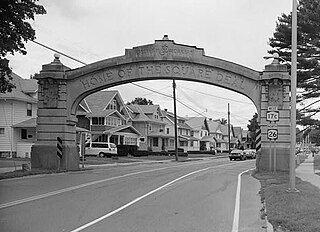
Endicott is a village in Broome County, New York, United States. The population was 13,392 at the 2010 census. It is part of the Binghamton Metropolitan Statistical Area. The village is named after Henry B. Endicott, a founding member of the Endicott Johnson Corporation shoe manufacturing company, who founded the community as the "Home of the Square Deal".

Endwell is a hamlet located in the town of Union in Broome County, New York, United States. Its population was 11,446 at the 2010 census.
Union is a town in Broome County, New York, United States. As of the 2010 census, the town had a total population of 56,346. The name derives from the town having served as a rendezvous for the Sullivan Expedition.
Apalachin is a census-designated place within the Town of Owego in Tioga County, New York, United States. The population was 1,131 in the 2010 census. The CDP is named after Apalachin Creek.
Barton is a town in southwestern Tioga County, New York, United States. The population was 8,570 at the 2020 census. It is southeast of Elmira.
Richford is a town in Tioga County, New York, United States. The population was 1,043 at the 2020 census. The town is named after Ezekial Rich, an early settler and benefactor of the town.
Tioga is a town in Tioga County, New York, United States. The population was 4,455 at the 2020 census. The town is in the southwestern part of the county and lies between Elmira and Binghamton. Tioga is situated in the Southern Tier District of New York.

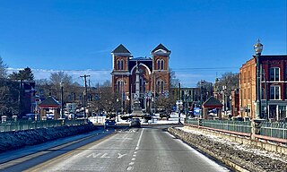
Waverly is the largest village in Tioga County, New York, United States. As of the 2010 U.S. census, Waverly had a population of 4,177. It is located southeast of Elmira in the Southern Tier region. This village was incorporated as the southwest part of the town of Barton in 1854. The village name was conceived by Joseph "Uncle Joe" Hallett, founder of its first Fire Department and pillar of the community, dropping the second "e" from the name of his favorite author's novel, Waverley by Sir Walter Scott. The former village hall is listed on the National Historic Places list.

Owego is a village in and the county seat of Tioga County, New York, United States. The population was 3,896 at the 2010 census. It is part of the Binghamton Metropolitan Statistical Area. The name is derived from the Iroquois word Ahwaga, meaning where the valley widens.
Owego is a town in Tioga County, New York, United States. The population was 18,728 at the 2020 census. The name is derived from the Iroquois word Ahwaga, meaning "where the valley widens".

New York State Route 434 (NY 434) is a state highway located in the Southern Tier of New York in the United States. The route extends for 20.89 miles (33.62 km) from an intersection with NY 96 in the village of Owego to an intersection with U.S. Route 11 (US 11) in the city of Binghamton. In between, NY 434 passes through the towns of Owego and Vestal. The portion of NY 434 from the Tioga–Broome county line to downtown Binghamton is known as the Vestal Parkway.

New York State Route 17C (NY 17C) is a state highway in the Southern Tier of New York in the United States. Its western terminus is at an intersection with NY 34 in Waverly, Tioga County while its eastern terminus is at an intersection with U.S. Route 11 (US 11) in Binghamton, Broome County. The route runs concurrently with NY 96 for a block in Owego and for a few blocks with NY 26 in Endicott.
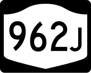
New York State Route 962J (NY 962J) is a 0.41-mile-long (0.66 km) southwest-northeast reference route that, unlike most reference routes, has been signed as a touring route in Southern Tier town of Owego in Tioga County, New York. Its southwestern terminus is at NY 17 and NY 434 in the census-designated place of Apalachin and its northeastern terminus is at NY 17C south of the hamlet of Campville.

The Binghamton Metropolitan Statistical Area, also called Greater Binghamton or the Triple Cities, is a region of southern Upstate New York in the Northeastern United States, anchored by Binghamton. The MSA encompasses Broome and Tioga counties, which together had a population of 247,138 as of the 2020 census. From 1963 to 1983, the MSA also included neighboring Susquehanna County in Pennsylvania, part of which still falls in the Binghamton, NY–PA Urban Area. In addition to these three counties, the greater region includes parts of Delaware and Chenango counties in New York; portions of Cortland and Otsego counties in New York and Wayne County, Pennsylvania are sometimes considered part of the region as well. Using the definition of a 30-mile radius from Binghamton, the population as of the 2010 census is 317,331.

Beaver Dam Lake is a census-designated place (CDP) in the towns of New Windsor, Blooming Grove, and Cornwall in Orange County, New York, United States. As of the 2020 census, it had a population of 2,609.
De Witt is a census-designated place (CDP) in the town of DeWitt, Onondaga County, New York, United States. It was first listed as a CDP prior to the 2020 census.
MacDonnell Heights is a census-designated place (CDP) in the town of Poughkeepsie in Dutchess County, New York, United States. It was first listed as a CDP prior to the 2020 census.
Tioga Terrace is a neighborhood and census-designated place (CDP) in the town of Owego, Tioga County, New York, United States. It was first listed as a CDP prior to the 2020 census.


