It is notable for its geothermal energy facilities and traditional pottery craft. It became the first water-based geothermal system in the world to generate more than 160 megawatts of power and now has an installed capacity of 289 MW. The town is also known for its coron, handcrafted pottery made in different shapes and sizes. Visitors can see the Tiwi Geothermal Power Plant from Naglagbong Geothermal People’s Park, often called Nag Park.[6]
Etymology
Friars called the place Tigbi, which evolved into Tivi and, then, finally to its present name Tiwi.[7][8]
History
Tiwi began as a barrio of Malinao before it was formally organized as a politically independent pueblo in 1696. As a pueblo, it was governed by a gobernadorcillo. As a Catholic parish, it was administered by a secular priest under the then Diocese of Nueva Caceres, now an archdiocese. In its primeval stages, it had some 1,105 houses, a parish church, a community-funded primary school, and a cemetery outside the town proper. The villagers ordinarily engaged in fishing, planting rice, corn, sugarcane, indigo, fruit-bearing trees, and vegetables. Aside from agriculture, they also busied themselves weaving cotton and abaca clothes, and in pottery.[9]
In Kagnipa, known today as Barangay Baybay, stands the dilapidated Sinimbahan. It is the remnant of the first concrete house of worship built by the Franciscans led by the pastor of Malinao, Fray Pedro de Brosas, remains to be the deaf witness of both the villagers' ready acceptance of the Christian faith and their suffering of persecution at the hands of the Moslems; Christian missionaries called them Moros. The parola by the shore of Sitio Nipa of the same barangay testifies to the people's paralyzing fear of the Moros' capricious forays. The market site of the pueblo before these raids was located in the present location of Baybay Elementary School. In order to sidetrack surprise attacks, at least temporarily, the market site was transferred to southernmost part of now Barangay Baybay; henceforth, it was called Binanwaan. The transfer, however, was useless. Finally, to have enough time to escape and keep themselves safer from their enemies' easy attacks, the inhabitants moved the market site and their settlement to the present poblacion now named as Barangay Tigbi. Before the Moro's assaults, Barangay Baybay was then the center of trade and commerce because of its easy accessibility to marine transportation of goods. The goods came from the islands of what are now known as Catanduanes, San Miguel, Rapu-Rapu, and Batan, not to mention those from adjoining pueblos in the mainland of Ibalon, now the province of Albay, and the Camarines.[9]
In the extant records of the municipality, the first chief executive of the municipal government was Don Lorenzo Mancilla installed in 1776.
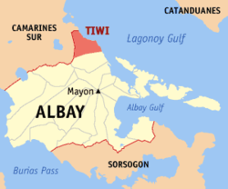
According to the Philippine Statistics Authority, the municipality has a land area of 105.76 square kilometres (40.83sqmi)[10] constituting 4.11% of the 2,575.77-square-kilometre- (994.51sqmi) total area of Albay. Tiwi is 38 kilometres (24mi) from Legazpi City and 565 kilometres (351mi) from Manila.
The town celebrates every year in August since 2006, the Coron Festival, where spectators enjoy a civic and float parade that showcase the town’s cultural heritage and its well-known pottery industry.[29]
Education
The Tiwi Schools District Office governs all educational institutions within the municipality. It oversees the management and operations of all private and public, from primary to secondary schools.[30]
Primary and elementary schools
Bagumbayan Elementary School
Bariis Elementary School
Baybay Elementary School
Belen Elementary School
Biyong Elementary School
Bolo Elementary School
Cale Elementary School
Cararayan-Naga Elementary School
Dapdap Elementary School
Joroan Elementary School
Libjo Elementary School
Libtong Elementary School
Lourdes Elementary School
Maynonong Elementary School
Mayong Elementary School
Misibis Elementary School
Nagas Elementary School
Putsan Elementary School
San Bernardo Elementary School
Spectrum Learning Center
Sto. Cristo Elementary School
Sugod Elementary School
Tabgon Elementary Schoo
Tiwi Central School
Secondary schools
Joroan High School
Naga National High School
Tiwi Agro-Industrial School
Higher educational institution
Our Lady of Salvacion College
Tiwi Community College
Gallery
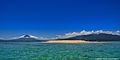
Corangon shoal, made up of mainly crushed corals and white sand, is about 15 minutes boat ride from the shore of barangay Baybay. Mounts Mayon (left), Masaraga (center) and Malinao (right) serve as the background.
↑The evolution of the nomenclature is not conclusive because a plant known as Tiwi (Bicol; Tua or Tui in Tagalog) also exists aside from the fact that the present poblacion was named differently being called Barangay Tigbi; otherwise, it would have been simply called "poblacion".
This page is based on this Wikipedia article Text is available under the CC BY-SA 4.0 license; additional terms may apply. Images, videos and audio are available under their respective licenses.