Daraga

Last updated

Daraga
Municipality of Daraga
Daraga and Albay.jpg
Daraga Church with Mayon Volcano in the background
Flag of Daraga, Albay.png
Daraga, Albay municipal seal.png
Nickname: 
The International Gateway to Bicol "Home of Cagsawa Ruins"
Motto: 
Arangkada Banwa
Ph locator albay daraga.png
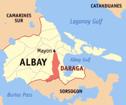
Map of Albay with Daraga highlighted
OpenStreetMap
Daraga
Philippines location map (square).svg
Red pog.svg
Daraga
Location within the Philippines
Coordinates: 13°09′43″N123°41′38″E / 13.1619°N 123.6939°E / 13.1619; 123.6939
Country Philippines
Region Bicol Region
Province Albay
District 2nd district
Founded June 12, 1772
Barangays 54 (see Barangays)
Government
[1]
  Type Sangguniang Bayan
   Mayor Carlwyn G. Baldo
   Vice Mayor Gerry Raphael Z. Jaucian Jr.
   Representative Jose Ma. Clemente "Joey" S. Salceda
   Municipal Council
Members
   Electorate 83,560 voters (2022)
Area
[2]
  Total118.64 km2 (45.81 sq mi)
Elevation
79 m (259 ft)
Highest elevation
292 m (958 ft)
Lowest elevation
0 m (0 ft)
Population
 (2020 census) [3]
  Total133,893
  Density1,100/km2 (2,900/sq mi)
   Households
30,777
Demonym Daragueño
Economy
   Income class 1st municipal income class
   Poverty incidence
13.51
% (2018) [4]
   Revenue 382.4 million (2020)
   Assets 1,514 million (2020)
   Expenditure 363.3 million (2020)
   Liabilities 521.5 million (2020)
Service provider
  ElectricityAlbay Power and Energy Corporation (APEC)
Time zone UTC+8 (PST)
ZIP code
4501
PSGC
IDD : area code +63(0)52
Native languages Tagalog
Website www.daraga.gov.ph

Daraga, officially the Municipality of Daraga (Central Bikol : Banwaan kan Daraga; Tagalog : Bayan ng Daraga), is a 1st class municipality in the province of Albay, Philippines. According to the 2020 census, it has a population of 133,893. [3]

Contents

The municipality is home to the famous Cagsawa Ruins.

History

The word daraga historically referred to a "maiden", and is the modern term for an "unmarried woman" in many of the Bikol languages. The original settlement of Daraga dates back to the 12th century, but has changed location repeatedly due to the constant threats posed by the Mayon Volcano. The town was previously named Budiao, Cagsawa, Locsin, and Salcedo.

YearEvent
12th c.Early settlers were mostly traders. The name Daraga came from a type of tree that was abundant on the hill where a baroque Catholic church now stands.
1578 Franciscan missionaries arrive, and christen the place Budiao, later renaming it to Cagsawa.
1595Cagsawa becomes a visita (satellite mission station) attached to the town of Camalig.
1772 Governor-General Simón de Anda renames Cagsawa to Salcedo, which is later renamed Daraga.
1814The municipality is destroyed in the deadliest eruption of Mayon Volcano, killing 1,200 people that sought refuge inside the church.
1815Government for Daraga is formally organized, with Venancio Espíritu Salomon as Barangay Captain.
1892Under the Becerra Law, Daraga becomes a constituent of Legazpi City.
1922Daraga regains its autonomy when the Philippine Assembly ordered the partition of Daraga from Albay, composed of Albay and Legazpi City.
1948Under Republic Act 306, Daraga is again incorporated into Legazpi as one of its districts. [5]
1954Republic Act 993 officially recreates the Municipality of Daraga. [6]
1959Daraga renamed to Locsin, through Republic Act No. 2505. [7]
1967Republic Act 4994 restores the name Daraga. [8]
1973Under Presidential Decree 125, Daraga is again incorporated as part of Legazpi City; [9] implementation of decree was suspended.
1993Daraga adjudged the 'cleanest and greenest' municipality in Bicol.
2001Mayon Volcano erupts in June, blanketing the town with an inch of ash.
2002Municipal government finishes construction of modern supermarket.
2006Mudflows from Mayon Volcano, triggered by heavy rains from Typhoon Reming (international name: Durian) buried at least eight villages. More than 20,000 Individuals were evacuated, and thousands lost their homes.
2007The National Museum declared the town's 400-year-old Our Lady of the Gate Parish Church a national cultural treasure.
2008Daraga experiences economic boom with the opening of several national food chains and the opening of LCC Supermarket.
2010The government of Daraga negotiates for the establishment of the Bicol International Airport in the town, with the proposed construction site in Barangay Alobo.
2012Daraga holds first ever Cagsawa Festival in February.
2016Daraga became the first applicant for cityhood in the 17th congress. [10]

Cityhood

House Bill No. 1528 was filed last July 4, 2019, for the conversion of the municipality of Daraga into a component city in the province of Albay. [11] The bill is currently pending with the committee on local government since July 24, 2019.

On July 6, 2022, House Bill No. 1303 was filed by Rep. Joey S. Salceda which seeks to convert Daraga into a component city.

Geography

Daraga is located at 13°09′43″N123°41′38″E / 13.1619°N 123.6939°E / 13.1619; 123.6939 , in the south-west portion of Albay province, along the Maharlika Highway, making it accessible from Manila, the Visayas, and the other municipalities of eastern Bicol Peninsula. It is roughly "boot-shaped", with the "tall" part ranging 13.0513.25° north latitude and 123.66123.73° east longitude and the "wide" part ranging 13.0213.09° north latitude and 123.56123.71° east longitude. It is bounded on the north and east by Legazpi City, south by Sorsogon (particularly the municipality of Pilar), and west by Camalig, and Jovellar. It is 3 kilometres (1.9 mi) from Legazpi and 524 kilometres (326 mi) from Manila.

According to the Philippine Statistics Authority, the municipality has a land area of 118.64 square kilometres (45.81 sq mi) [12] constituting

Elevation

67.3% of the total municipal land area has a predominantly low elevation of up to 100 metres (330 ft). The surface terrain is generally characterized by combination of level to nearly level areas, gentle to undulating areas and undulating to rolling areas.

Soil

The different soil types to be found within Daraga are the Mayon Gravelly Sandy Loam, Annam Clay Loam, Gravelly Sandy Loam, Legazpi Fine Sandy Loam (Stoney phase), Sevilla Clay Loam and Sevilla Clay.

The underlying geology are made up of several types: Alluvium, Shale and Sandstone Limestone and Basalt and Andesite Series. The prevalent geologic type is the Shale and Sandstone Sequence and other equally significant geologic types such as alluvium. Recent Volcanic, Crystalline Limestone and Psyroclastine Limestone are found near the base of Mayon Volcano mostly in the urban barangays.

Minerals available within the municipality of Daraga are non-metallic consisting of Gravel, and Boulders. These minerals are abundant in Barangays Budiao, Busay, Bañadero and Matnog brought down from the slopes of Mayon Volcano during occurrences of volcanic eruptions and rains.

Drainage

The surface drainage pattern of Daraga is largely affected by the water runoff coming from Mayon Volcano coupled with those from other directions. Major river systems which convey and act as natural drainage channels as well as water sources include:

Climate

Climate data for Daraga, Albay
MonthJanFebMarAprMayJunJulAugSepOctNovDecYear
Mean daily maximum °C (°F)27
(81)
28
(82)
29
(84)
31
(88)
31
(88)
30
(86)
29
(84)
29
(84)
29
(84)
29
(84)
29
(84)
28
(82)
29
(84)
Mean daily minimum °C (°F)22
(72)
21
(70)
22
(72)
23
(73)
24
(75)
25
(77)
25
(77)
25
(77)
24
(75)
24
(75)
23
(73)
22
(72)
23
(74)
Average precipitation mm (inches)65
(2.6)
44
(1.7)
42
(1.7)
39
(1.5)
87
(3.4)
150
(5.9)
184
(7.2)
153
(6.0)
163
(6.4)
154
(6.1)
127
(5.0)
100
(3.9)
1,308
(51.4)
Average rainy days13.99.211.112.519.624.326.525.025.524.419.415.1226.5
Source: Meteoblue [14]

Daraga has a generally wet climate characterized by a lack of the dry season. Maximum rainfall is from November to January, and average monthly rainfall is 223.4 millimetres (8.80 in). Prevailing winds are generally from north-east to south-west. Average temperature is 27.0 °C (80.6 °F). [13]

But the climate change phenomenon has changed the past climate pattern. Dry spells are becoming more pronounced, as it is with the wet season. The phenomenon is felt all over the country as well.

Barangays

Daraga is politically subdivided into 54 barangays. [15] Each barangay consists of puroks and some have sitios.

BarangayPopulation (2010) [16] Area (ha) [17] ClassBarangay head
Alcala2,755116.18RuralEster L. Llandeza
Alobo792160.65RuralDexter L. Marmol
Anislag9,445858.50UrbanElmer Lodronio
Bagumbayan3,254132.54UrbanMark C. Magalona
Balinad2,230153.74UrbanDarren Maceda
Bañadero1,637204.00RuralArchie Bajamundi
Bañag2,71927.35UrbanGayzel M. Cardiño
Bascaran3,946423.00UrbanJulius L. Duran
Bigao1,015296.08RuralSalvador Miravalles
Binitayan4,25724.06UrbanCecilia A. Arevalo
Bongalon1,12373.48RuralFerelyn M. Seva
Budiao271290.07RuralJefferson M. Mapula
Burgos1,122148.67Rural (Urban)Pilar L Llanera
Busay1,684213.79RuralSalvyn Mandane
Canarom501247.36RuralEfren M. Llasos
Cullat1,46030.78RuralLuis D. Espejo
de la Paz77373.19RuralMaria L. Marjalino
Dinoronan60861.07RuralHirfa M. Espadilla
Gabawan1,98393.18RuralRoberto C. Obispo
Gapo1,982389.25RuralJesus M. Magdaong Jr
Ibaugan546179.00RuralRaul Ll. Malto
Ilawod1,98718.42UrbanRandy Kabayo Velasco
Inarado1,694682.22RuralRommel N. Marticio
Kidaco1,205116.03RuralNelson Magallano
Kilicao3,925379.43UrbanEriberto M. Madrona
Kimantong1,98020.98UrbanRamon D. Paran Jr.
Kinawitan40578.46RuralEduardo N. Lubiano
Kiwalo1,16057.65RuralJanet L. Lorilla
Lacag2,321383.86RuralArthur L. Llabore Sr.
Mabini581124.83RuralRanulfo N. Llorera
Malabog4,099287.46RuralPaulo Montallana
Malobago49261.56RuralWilliam Marbella
Maopi1,166252.95RuralAlex M.LoteriÑA
Market Area2,53820.82UrbanWilfredo N. Nayve
Maroroy 5,33173.60UrbanRobinson "toto" Lubiano
Matnog1,680270.15RuralBonifacio M. Odiver
Mayon1,759356.70RuralAdoracion Blazo
Mi-isi1,028518.20RuralElmer A. Lorica
Nabasan506552.14RuralMenche A. Llamasares
Namantao1,538363.07RuralDanilo Llaneta
Pandan1,68394.32RuralRosalito Cimanes
Peñafrancia2,986193.74UrbanJose M. Lobas
Sagpon5,72329.62UrbanLoreto Barajas
Salvacion3,344551.61RuralNelson N. Mabini
San Rafael29632.64RuralAlodea M. Lisay
San Ramon1,441784.99RuralAidar L. Llaguno
San Roque4,30841.97UrbanGary Calpe
San Vicente Grande961346.57RuralElena M. Vibar
San Vicente Pequeño32063.67RuralJesus Oarde
Sipi3,45438.92UrbanDexter Billy M. Lorica
Tabon-tabon2,588207.99RuralRic M. Rodrigueza
Tagas6,527100.45UrbanCherry M. Mayor
Talahib541341.93RuralNieves M. Jacob
Villahermosa2,203414.71RuralEladio L. Rodrigueza

Demographics

Population census of Daraga
YearPop.±% p.a.
1903 18,695    
1939 29,484+1.27%
1960 41,973+1.70%
1970 58,335+3.34%
1975 63,265+1.64%
1980 73,224+2.97%
1990 83,928+1.37%
1995 91,829+1.70%
2000 101,031+2.07%
2007 110,625+1.26%
2010 115,804+1.68%
2015 126,595+1.71%
2020 133,893+1.11%
Source: Philippine Statistics Authority [18] [16] [19] [20]

In the 2020 census, Daraga had a population of 133,893. [3] The population density was 1,100 inhabitants per square kilometre (2,800/sq mi).

In 2010, the 2010 municipal population of 115,804 was distributed among the urban and rural barangays. The urban population was 48.54% while rural population completed the remaining 51.45%. The "built-up density" was 5,659 persons/km2. It had a literacy rate of 96.08% and a municipality growth rate of 1.3%.

In terms of employment and livelihood, farming ranks high at 33.53%, crafts and related workers as well as elementary occupations follow second with 17.71% and 21.89% respectively.

Language

The languages spoken in Daraga include East Miraya (Daragueño), Bicol, Tagalog, and English.

Economy

The tower is what remains of the Cagsawa Church, which was buried by the 1814 eruption of Mayon Volcano. CAGSAWA RUINS.jpg
The tower is what remains of the Cagsawa Church, which was buried by the 1814 eruption of Mayon Volcano.

Daraga's economy, originally agriculture-based, has rapidly transformed into an emerging urban system, benefiting from the economic opportunities of being located contiguously with the urban center of Legazpi. It draws trade relations with the island province of Masbate through the nearby Port of Pilar.

Daraga is the site of the Bicol International Airport which will further boost tourism in the region and will introduce more opportunities especially in this town. Local officials are now considering cityhood in the near future or upon the completion of the said international airport, if that so, Daraga would be the fourth city in Albay.

Daraga has the highest number of business establishments among towns in Albay. As of 2011 it has over 2,300 business establishments registered with the Permits and Licensing Office. The municipality is a center of handicraft manufacturing with several handicraft factories choosing their location in the municipality.

Government

The current town mayor is Carlwyn “Awin” G. Baldo.

Tourism

Our Lady of the Gate Parish or Daraga Church Daraga church.JPG
Our Lady of the Gate Parish or Daraga Church

Daraga's existing tourist spots/attractions are the Cagsawa Ruins and Resort and the Our Lady of the Gate Parish.

Cagsawa Ruins and Resort is located in Barangay Busay. Its prominent attraction is the belfry of the Cagsawa Church which submerged in mudflow during the February 2, 1814, Mayon Volcano Eruption which killed 1,200 people.

The Our Lady of the Gate Parish was constructed in 1773 atop Santa Maria Hill in Barangay San Roque and is uniquely known for its rich Baroque architecture.

Transportation

Daraga has a total road network of about 129.01 kilometres (80.16 mi). These are categorized as national roads, provincial roads, municipal roads and barangay roads. The barangay roads comprise the bulk of the municipality road network system. About 24.97% are concrete paved while the remaining 75.03% remains in asphalt, gravel or earth fill pavement conditions. These are about 25 bridges within the municipality and 66.22% of which are within barangay roads while the other bridges are part of national, provincial or barangay roads.

Daraga is the site of the newly constructed Bicol International Airport. It serves the City of Legazpi and the rest of Albay. It is located at barangay Alobo.

Education

Elementary

Each barangay of Daraga has its own elementary school.

High school

  • Anislag National High School
  • Anislag National High School - Bascaran HS Extension
  • Anislag National High School - San Vicente Grande HS Extension
  • Banadero National High School
  • Bicol College (BC) - High School Department.
  • Daraga National High School (DNHS)
  • Immaculate Concepcion College of Albay (ICCA) - High School Department
  • Kilicao High School
  • Lacag National High School
  • Malabog National High School
  • Mary's Child Science Oriented School (MCSOS) - High School Department
  • United Institute (U.I.) - High School Department

College

Notable people

Related Research Articles

<span class="mw-page-title-main">Albay</span> Province in Bicol, Philippines

Albay, officially the Province of Albay, is a province in the Bicol Region of the Philippines, mostly on the southeastern part of the island of Luzon. Its capital is the city of Legazpi, the regional center of the whole Bicol Region, which is located in the southern foothill of Mayon Volcano.

<span class="mw-page-title-main">Bicol Region</span> Administrative region of the Philippines

The Bicol Region, commonly shortened to Bicol and designated as Region V, is an administrative region of the Philippines. Also referred to as Bicolandia, it comprises six provinces, four on the Bicol Peninsula : Albay, Camarines Norte, Camarines Sur, and Sorsogon, and two off the shore: Catanduanes and Masbate.

<span class="mw-page-title-main">Legazpi, Albay</span> Capital and largest city of Albay, Philippines

Legazpi, officially the City of Legazpi, is a 1st class component city and capital of the province of Albay, Philippines. According to the 2020 census, it has a population of 209,533. Legazpi is the regional center and largest city of the Bicol Region, in terms of population. It is the region's center of tourism, education, health services, commerce and transportation in the Bicol Region.

<span class="mw-page-title-main">Tabaco</span> Component city in Albay, Philippines

Tabaco, officially the City of Tabaco, is a 4th class component city in the province of Albay, Philippines. According to the 2020 census, it has a population of 140,961 people.

<span class="mw-page-title-main">Guinobatan</span> Municipality in Albay, Philippines

Guinobatan, officially the Municipality of Guinobatan, is a 1st class municipality in the province of Albay, Philippines. According to the 2020 census, it has a population of 85,786 people.

<span class="mw-page-title-main">Oas, Albay</span> Municipality in Albay, Philippines

Oas, officially the Municipality of Oas, is a 1st class municipality in the province of Albay, Philippines. According to the 2020 census, it has a population of 66,084 people.

<span class="mw-page-title-main">Bacacay</span> Municipality in Albay, Philippines

Bacacay, officially the Municipality of Bacacay, is a 2nd class municipality in the province of Albay, Philippines. According to the 2020 census, it has a population of 72,485 people. Bacacay is primarily an agricultural town and abundant in seafood.

<span class="mw-page-title-main">Camalig</span> Municipality in Albay, Philippines

Camalig, officially the Municipality of Camalig, is a 1st class municipality in the province of Albay, Philippines. According to the 2020 census, it had a population of 72,042 people. It is known for one of Bicol's finest delicacy, Pinangat.

<span class="mw-page-title-main">Libon, Albay</span> Municipality in Albay, Philippines

Libon, officially the Municipality of Libon, is a 1st class municipality in the province of Albay, Philippines. According to the 2020 census, it has a population of 75,073 people.

<span class="mw-page-title-main">Malilipot</span> Municipality in Albay, Philippines

Malilipot, officially the Municipality of Malilipot, is a 4th class municipality in the province of Albay, Philippines. According to the 2020 census, it has a population of 40,857 people.

<span class="mw-page-title-main">Malinao, Albay</span> Municipality in Albay, Philippines

Malinao, officially the Municipality of Malinao, is a 3rd class municipality in the province of Albay, Philippines. According to the 2020 census, it has a population of 47,395 people.

<span class="mw-page-title-main">Manito, Albay</span> Municipality in Albay, Philippines

Manito, officially the Municipality of Manito, is a 4th class municipality in the province of Albay, Philippines. According to the 2020 census, it has a population of 26,162.

<span class="mw-page-title-main">Pio Duran</span> Municipality in Albay, Philippines

Pio Duran, officially the Municipality of Pio Duran, is a 3rd class municipality in the province of Albay, Philippines. According to the 2020 census, it has a population of 49,070 people.

<span class="mw-page-title-main">Polangui</span> Municipality in Albay, Philippines

Polangui, officially the Municipality of Polangui, is a 1st class municipality in the province of Albay, Philippines. According to the 2020 census, it has a population of 89,176 people.

<span class="mw-page-title-main">Santo Domingo, Albay</span> Municipality in Albay, Philippines

Santo Domingo, officially the Municipality of Santo Domingo,, is a 4th class municipality in the province of Albay, Philippines. According to the 2020 census, it has a population of 37,765 people.

<span class="mw-page-title-main">Tiwi, Albay</span> Municipality in Albay, Philippines

Tiwi, officially the Municipality of Tiwi is a 1st class municipality in the Province of Albay, Philippines. According to the 2020 census, it has a population of 56,444 people.

<span class="mw-page-title-main">Ligao</span> Component city in Albay, Philippines

Ligao, officially the City of Ligao, is a 4th class component city in the province of Albay, Philippines. According to the 2020 census, it has a population of 118,096 people. Most of the city's economy came from agriculture sector.

<span class="mw-page-title-main">Buhi, Camarines Sur</span> Municipality in Camarines Sur, Philippines

Buhi, officially the Municipality of Buhi, is a 1st class municipality in the province of Camarines Sur, Philippines. According to the 2020 census, it has a population of 81,306 people.

<span class="mw-page-title-main">Cagsawa Ruins</span> Destroyed church in the Philippines

The Cagsawa Ruins are the remnants of a 16th-century Franciscan church, the Cagsawa church. It was originally built in the town of Cagsawa in 1587 but was burned down and destroyed by Dutch pirates in 1636. It was rebuilt in 1724 by Fr. Francisco Blanco but was destroyed again, along with the town of Cagsawa, on February 1, 1814, during the eruption of Mayon Volcano.

<span class="mw-page-title-main">Daraga Church</span> Roman Catholic church in Albay, Philippines

Nuestra Señora de la Porteria Parish Church, commonly known as Daraga Church, is a Roman Catholic church in the municipality of Daraga, Albay, Philippines under the jurisdiction of the Roman Catholic Diocese of Legazpi. The church was built by the Franciscans in 1772 under the patronage of the Our Lady of the Gate. Certain church sections were declared as a National Cultural Treasure of the Philippines in 2007.

References

  1. Municipality of Daraga | (DILG)
  2. "2015 Census of Population, Report No. 3 – Population, Land Area, and Population Density" (PDF). Philippine Statistics Authority. Quezon City, Philippines. August 2016. ISSN   0117-1453. Archived (PDF) from the original on May 25, 2021. Retrieved July 16, 2021.
  3. 1 2 3 Census of Population (2020). "Region V (Bicol Region)". Total Population by Province, City, Municipality and Barangay. Philippine Statistics Authority . Retrieved July 8, 2021.
  4. "PSA Releases the 2018 Municipal and City Level Poverty Estimates". Philippine Statistics Authority. December 15, 2021. Retrieved January 22, 2022.
  5. "Republic Act No. 306 - An Act Creating the City of Legaspi". Chan Robles Virtual Law Library. June 18, 1948. Archived from the original on March 4, 2016. Retrieved October 23, 2016.
  6. "Chan Robles Virtual Law Library". Republic Act No. 993 - An Act Recreating the Municipalities of Legaspi and Daraga in the Province of Albay. June 8, 1954. Archived from the original on September 25, 2013. Retrieved October 23, 2016.
  7. "Republic Act No. 2505 - An Act Changing the Name of the Municipality of Daraga, Province of Albay, to Municipality of Locsin". Chan Robles Virtual Law Library. June 21, 1959. Archived from the original on June 3, 2012. Retrieved October 23, 2016.
  8. "Republic Act No. 4994 - An Act Changing the Name of the Municipality of Locsin, Province of Albay, to Municipality of Daraga". Chan Robles Virtual Law Library. June 17, 1967. Archived from the original on September 26, 2013. Retrieved October 23, 2016.
  9. "Presidential Decree No. 125; Amending Certain Provisions of Republic Act No. 2234, Otherwise Known As the City Charter of Legazpi, and For Other Purposes". Official Gazette of the Republic of the Philippines. Malacañang, Manila, Philippines. February 5, 1973. Retrieved October 23, 2016.
  10. Basmayor, MV. "Daraga is first applicant for cityhood in 17th Congress". Bicol Standard. Archived from the original on October 20, 2016. Retrieved October 23, 2016.
  11. Sarte, Joey. "AN ACT CONVERTING THE MUNICIPALITY OF DARAGA, ALBAY PROVINCE, INTO A COMPONENT CITY TO BE KNOWN AS THE CITY OF DARAGA" (PDF). House of Representatives. Archived (PDF) from the original on June 3, 2020. Retrieved April 20, 2021.
  12. "Province: Albay". PSGC Interactive. Quezon City, Philippines: Philippine Statistics Authority . Retrieved November 12, 2016.
  13. 1 2 "General Information". About the LGU. Municipal Government of Daraga. Archived from the original on April 25, 2012. Retrieved January 21, 2013.
  14. "Daraga, Albay : Average Temperatures and Rainfall". Meteoblue. Retrieved December 29, 2018.
  15. "Municipal: Daraga". PSGC Interactive. Quezon City, Philippines: Philippine Statistics Authority . Retrieved January 8, 2016.
  16. 1 2 Census of Population and Housing (2010). "Region V (Bicol Region)" (PDF). Total Population by Province, City, Municipality and Barangay. National Statistics Office . Retrieved June 29, 2016.
  17. Daraga Municipal Planning and Development Office
  18. Census of Population (2015). "Region V (Bicol Region)". Total Population by Province, City, Municipality and Barangay. Philippine Statistics Authority . Retrieved June 20, 2016.
  19. Censuses of Population (1903–2007). "Region V (Bicol Region)". Table 1. Population Enumerated in Various Censuses by Province/Highly Urbanized City: 1903 to 2007. National Statistics Office.{{cite encyclopedia}}: CS1 maint: numeric names: authors list (link)
  20. "Province of Albay". Municipality Population Data. Local Water Utilities Administration Research Division. Retrieved December 17, 2016.
  21. "Poverty incidence (PI):". Philippine Statistics Authority. Retrieved December 28, 2020.
  22. "Estimation of Local Poverty in the Philippines" (PDF). Philippine Statistics Authority. November 29, 2005.
  23. "2003 City and Municipal Level Poverty Estimates" (PDF). Philippine Statistics Authority. March 23, 2009.
  24. "City and Municipal Level Poverty Estimates; 2006 and 2009" (PDF). Philippine Statistics Authority. August 3, 2012.
  25. "2012 Municipal and City Level Poverty Estimates" (PDF). Philippine Statistics Authority. May 31, 2016.
  26. "Municipal and City Level Small Area Poverty Estimates; 2009, 2012 and 2015". Philippine Statistics Authority. July 10, 2019.
  27. "PSA Releases the 2018 Municipal and City Level Poverty Estimates". Philippine Statistics Authority. December 15, 2021. Retrieved January 22, 2022.

Commons-logo.svg Media related to Daraga at Wikimedia Commons