Tollmann's hypothetical bolide

Last updated

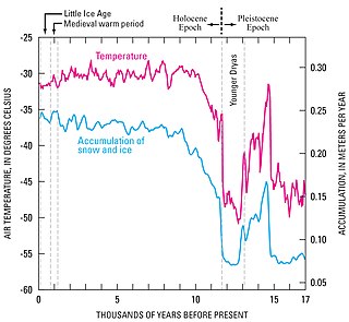
Alexander Tollmann's bolide, proposed by Edith Kristan-Tollmann and Alexander Tollmann in 1994, [1] is a hypothesis presented by Austrian geologist Alexander Tollmann and paleontologist Edith Kristan-Tollmann, suggesting that one or several bolides (asteroids or comets) struck the Earth at 7640 BCE (±200), with a much smaller one at 3150 BCE (±200). If true, this hypothesis explains early Holocene extinctions and possibly legends of the Universal Deluge. [1]

Edith Kristan-Tollmann nee Edith Kristan was an Austrian geologist and paleontologist. A prolific scientist with an interest in micropalaeontology and especially the foraminifera of the Triassic and the Jurassic eras, Kristan-Tollmann published widely in her field. She is also known for originating with her husband Alexander Tollmann a thoroughly documented theory of the evolution of human legend and social structures as a result of a massive impact event which struck multiple points on earth. The latter has become known as Tollmann's hypothetical bolide.

Dr. Alexander Tollmann was an Austrian professor of geology.

Austria Federal republic in Central Europe

Austria, officially the Republic of Austria, is a country of nearly 9 million people in Central Europe. It is bordered by the Czech Republic and Germany to the north, Hungary and Slovakia to the east, Slovenia and Italy to the south, and Switzerland and Liechtenstein to the west. The territory of Austria covers 83,879 km2 (32,386 sq mi). The terrain is highly mountainous, lying within the Alps; only 32% of the country is below 500 m (1,640 ft), and its highest point is 3,798 m (12,461 ft). The majority of the population speaks local Bavarian dialects as their native language, and German in its standard form is the country's official language. Other local official languages are Hungarian, Burgenland Croatian, and Slovene.

Contents

The claimed evidence for the event includes stratigraphic studies of tektites, [2] [3] [4] dendrochronology, and ice cores (from Camp Century, Greenland) containing hydrochloric acid and sulfuric acid (indicating an energetic ocean strike) as well as nitric acids (caused by extreme heating of air).

Stratigraphy The study of rock layers and their formation

Stratigraphy is a branch of geology concerned with the study of rock layers (strata) and layering (stratification). It is primarily used in the study of sedimentary and layered volcanic rocks. Stratigraphy has two related subfields: lithostratigraphy and biostratigraphy.

Dendrochronology method of dating based on the analysis of patterns of tree rings

Dendrochronology is the scientific method of dating tree rings to the exact year they were formed. As well as dating them this can give data for dendroclimatology, the study of climate and atmospheric conditions during different periods in history from wood.

Ice core Cylindrical sample drilled from an ice sheet

An ice core is a core sample that is typically removed from an ice sheet or a high mountain glacier. Since the ice forms from the incremental buildup of annual layers of snow, lower layers are older than upper, and an ice core contains ice formed over a range of years. Cores are drilled with hand augers or powered drills; they can reach depths of over two miles (3.2 km), and contain ice up to 800,000 years old.

Christopher Knight and Robert Lomas in their book, Uriel's Machine , argue that the 7640 BCE evidence is consistent with the dates of formation of a number of extant salt flats and lakes in dry areas of North America and Asia. They argue that these lakes are the result remains of multiple-kilometer-high waves that penetrated deeply into continents as the result of oceanic strikes that they proposed occurred.

Christopher Knight is an author who has written several books dealing with theories such as 366-degree geometry and the origins of Freemasonry. Knight appears in the two-part History Channel documentary Decoding the Past – "Mysteries of the Freemasons".

Robert Lomas is a British writer, physicist and business studies academic. He writes primarily about the history of Freemasonry as well as the Neolithic period, ancient engineering and archaeoastronomy.

Uriel's Machine: The Prehistoric Technology That Survived the Flood is a bestselling book published in 1999 by Christopher Knight and Robert Lomas. The book's name is derived from a character of the same name in the Book of Enoch. In Knight and Lomas's interpretation of the Book of Enoch, Uriel warns Enoch about the impending flood, giving him instructions for building a form of solar observatory for the purpose of preserving advanced knowledge into a time of global disaster by teaching him the movement of the Sun against the horizon over a period of time, which Enoch then records in detail in the Book of the Courses of the Heavenly Luminaries.

Scientific evaluation

Quaternary geologists, paleoclimatologists, and planetary geologists specializing in meteorite and comet impacts have rejected the Tollmann bolide hypothesis. [5] They reject this hypothesis because:

Quaternary is the current and most recent of the three periods of the Cenozoic Era in the geologic time scale of the International Commission on Stratigraphy (ICS). It follows the Neogene Period and spans from 2.588 ± 0.005 million years ago to the present. The Quaternary Period is divided into two epochs: the Pleistocene and the Holocene. The informal term "Late Quaternary" refers to the past 0.5–1.0 million years.

Geologist Scientist who studies geology

A geologist is a scientist who studies the solid, liquid, and gaseous matter that constitutes the Earth and other terrestrial planets, as well as the processes that shape them. Geologists usually study geology, although backgrounds in physics, chemistry, biology, and other sciences are also useful. Field work is an important component of geology, although many subdisciplines incorporate laboratory work.

Meteorite piece of solid matter from outer space that has hit the earth

A meteorite is a solid piece of debris from an object, such as a comet, asteroid, or meteoroid, that originates in outer space and survives its passage through the atmosphere to reach the surface of a planet or moon. When the object enters the atmosphere, various factors such as friction, pressure, and chemical interactions with the atmospheric gases cause it to heat up and radiate that energy. It then becomes a meteor and forms a fireball, also known as a shooting star or falling star; astronomers call the brightest examples "bolides". Meteorites vary greatly in size. For geologists, a bolide is a meteorite large enough to create an impact crater.

  1. The evidence offered to support the hypothesis can more readily be explained by more mundane and less dramatic geologic processes
  2. Many of the events alleged to be associated with this impact occurred at the wrong time (i.e., many of the events occurred hundreds to thousands of years before or after the hypothesized impacts); and
  3. There is a lack of any credible physical evidence for the cataclysmic environmental devastation and characteristic deposits that kilometer-high tsunamis would have created had they actually occurred. [5]

Much of the evidence used by the Tollmann bolide hypothesis to argue for catastrophic Holocene impacts can be just as well, in most cases even better, explained by more pedestrian geological processes. For example, the chemical composition of and the presence of volcanic ash with the specific acidity spikes in the Greenland ice cores presents clear evidence that they are volcanic, not impact, in origin. [6] [7] Also, the largest acidity spikes found in Antarctica ice cores are far too old, from 17,300 to 17,500 BP, to be associated with any Holocene impacts. [8] The formation of modern salt lakes and salt flats is readily explained by the concentration of salts and other evaporite minerals by the evaporation of water from stream-fed lakes lacking external outlets, called "endorheic lakes", in arid climates. The composition of the salts and other evaporate minerals found in these lakes is consistent with their precipitation from dissolved material continually carried into the lakes by rivers and streams and subsequent concentration by evaporation instead of evaporation of sea water. [9] [10] [11] Whether a lake becomes salty or not simply depends on whether the lake lacks an outlet and the relative balance between water flowing into the lake and leaving the lake via evaporation. [9] Ocean water dumped into a lake as the result of a single catastrophic event, as suggested above, would contain an inadequate amount of dissolved minerals to produce, when evaporated, the vast quantities of salts and other evaporites found in the salt lakes, flats, and pans cited as evidence of a mega-tsunami by this hypothesis.

Holocene The current geological epoch, covering the last 11,700 years

The Holocene is the current geological epoch. It began approximately 11,650 cal years before present, after the last glacial period, which concluded with the Holocene glacial retreat. The Holocene and the preceding Pleistocene together form the Quaternary period. The Holocene has been identified with the current warm period, known as MIS 1. It is considered by some to be an interglacial period within the Pleistocene Epoch.

Volcanic ash volcanic material formed during explosive eruptions with the diameter of the grains less than 2 mm

Volcanic ash consists of fragments of pulverized rock, minerals and volcanic glass, created during volcanic eruptions and measuring less than 2 mm (0.079 inches) in diameter. The term volcanic ash is also often loosely used to refer to all explosive eruption products, including particles larger than 2 mm. Volcanic ash is formed during explosive volcanic eruptions when dissolved gases in magma expand and escape violently into the atmosphere. The force of the escaping gas shatters the magma and propels it into the atmosphere where it solidifies into fragments of volcanic rock and glass. Ash is also produced when magma comes into contact with water during phreatomagmatic eruptions, causing the water to explosively flash to steam leading to shattering of magma. Once in the air, ash is transported by wind up to thousands of kilometers away.

Greenland autonomous country within the Kingdom of Denmark

Greenland is an autonomous constituent country of the Kingdom of Denmark between the Arctic and Atlantic oceans, east of the Canadian Arctic Archipelago. Though physiographically a part of the continent of North America, Greenland has been politically and culturally associated with Europe for more than a millennium. The majority of its residents are Inuit, whose ancestors began migrating from the Canadian mainland in the 13th century, gradually settling across the island.

Geological criticism

Isostatic rebound

Many published papers [12] [13] clearly demonstrate that isostatic depression of the Earth's crust is not only real, but quite capable of submerging substantial portions of coastal areas adjacent to continental ice sheets and resulting in the accumulations of marine sediments and fossils within them. A well-documented example of flooding caused by isostatic depression is the case of Charlotte, The Vermont Whale, [14] a fossil whale found in the deposits of the former Champlain Sea. Like many similar marine deposits, the sediments, which accumulated within the Champlain Sea lack the physical characteristics; i.e. sedimentary structures, interlayering, and textures, that characterize sediments deposited by a mega-tsunami. In addition, many of these deposits and the fossils, which they contain, are far too old, by hundreds to thousands of years, to have been created by impact around either 9,640 BP or 5,150 BP. In case of the Champlain Sea, its sediments started to accumulate around 13,000 BP, almost 3,400 years before the oldest of the hypothesized Holocene bolide impacts. [15]

Isostatic depression

Isostatic depression is the sinking of large parts of the Earth's crust into the asthenosphere. The sinking is caused by a heavy weight placed on the Earth's surface. Often this is caused by the heavy weight of glacial ice due to continental glaciation. This is a process in which permanent ice places pressure on the Earth's crust, thereby depressing it with its weight. After continental glaciation has receded, it is common for isostatic rebound to occur.

Earth Third planet from the Sun in the Solar System

Earth is the third planet from the Sun and the only astronomical object known to harbor life. According to radiometric dating and other sources of evidence, Earth formed over 4.5 billion years ago. Earth's gravity interacts with other objects in space, especially the Sun and the Moon, Earth's only natural satellite. Earth revolves around the Sun in 365.26 days, a period known as an Earth year. During this time, Earth rotates about its axis about 366.26 times.

Ice sheet large mass of glacier ice

An ice sheet, also known as a continental glacier, is a mass of glacial ice that covers surrounding terrain and is greater than 50,000 km2 (19,000 sq mi). The only current ice sheets are in Antarctica and Greenland; during the last glacial period at Last Glacial Maximum (LGM) the Laurentide ice sheet covered much of North America, the Weichselian ice sheet covered northern Europe and the Patagonian Ice Sheet covered southern South America.

Dating

As noted above, a significant amount of the physical evidence used by Kristan-Tollmann and Tollmann [1] to argue for this Holocene impact is either too old or too young to have been created by this hypothesized impact. In many cases, it is hundreds to thousands, and in one case hundreds of thousands, of years too old to be credible evidence of a Holocene impact. For example, the research [2] [3] [4] that dates the tektites, which Tollmann bolide hypothesis regards as indicating the time of the hypothesized impact, is antiquated. Later research, [16] [17] [18] has shown the tektites to be far too old, about 790,000 BP in case of the Australasian tektites, to have been associated with any of his hypothesized Holocene impacts. At this time, there exist no documented examples of Holocene tektites. In addition, the formation of salt lakes and salt flats is neither synchronous nor consistent with the hypothesized impacts having occurred about either 9,640 BP or 5,150 BP. For example, in case of Lake Bonneville, Lake Lahontan, Mono Lake, and other Pleistocene pluvial lakes in the western United States, the transition to salt lakes and salt flats occurred at different times between 12,000 and 16,000 BP. [19] Thus, the change from freshwater to salty water and eventually salt flats started over 2,400 to 6,400 years before the oldest of the impacts hypothesized by the Tollmann bolide hypothesis occurred. As a result, it is impossible that the formation of these salt lakes could have been associated with the impact hypothesized by Kristan-Tollmann and Tollmann. [1]

Megatsunami

Finally, credible physical evidence of either multiple-kilometer-high tsunami waves penetrating deeply into continents and the ecological devastation they would have certainly caused have yet to be reported from any of the thousands of paleoenvironmental records constructed from the study of lakes, bogs, mires, and river valleys all over the world by palynologists. In the case of North America, various peer-reviewed publications [20] [21] [22] [23] summarize numerous published scientific papers that provide detailed records of paleoenvironmental changes that have occurred throughout the last 10,000 to 15,000 years as reconstructed from pollen and other paleoenvironmental data from over a thousand sites throughout North America. In none of these records, have palynologists recognized any indication of either the catastrophic environmental devastation or layers of tsunami deposits, which the mega-tsunamis postulated by the Tollmann bolide hypothesis would have created. Paleovegetation maps [22] [24] illustrate a distinct lack of the dramatic changes in North American paleovegetation during the Holocene, which would be expected from the cataclysmic ecological and physical destruction that a continental-wide mega-tsunamis would have certainly have caused.

For example, E. C. Grimm G. L. Jacobson and others [25] documented a 50,000-year-long record of environmental change by the analysis of pollen from an 18.5 m (61 ft) core from Lake Tulane in Highland county, Florida. Because of the low-lying nature of the peninsula, in which this part of Florida lies, this lake and the area around it certainly would have been flooded and obliterated along with many of the other lakes and bogs described in their [25] and other publications. [21] The forests and associated ecosystems of these areas would have been flooded and completely obliterated by the mega-tsunamis proposed by Kristan-Tollmann and Tollmann. [1] Despite its location, both the core and the pollen record recovered from Lake Tulane completely lacks any indication of any abrupt, catastrophic environmental disruptions, [25] which the mega-tsunamis proposed by the Tollmann bolide hypothesis would have caused. This and other cores from Florida and elsewhere also lack sedimentary layers that have the characteristics of sediments deposited by either tsunamis or mega-tsunamis.

The cataclysmic scale of physical and ecological destruction that a megatsunami, like the one proposed by Kristan-Tollmann and Tollmann, [1] would have caused to the Holocene landscape and ecosystems certainly would have left an obvious and readily recognizable signature within the majority of long-term environmental records. Such a signature has not been reported from the more than thousand cores from North America for which Holocene paleoclimatic and paleoenvironmental records have been reconstructed. There is a similar lack of evidence for mega-tsunami related, Holocene, catastrophic environmental disruptions and deposits reported from environmental records reconstructed from thousands of locations from all over the world. This lack of a physical record for the occurrence of Holocene mega-tsunamis is quite revealing given that geologists and palynologists have been quite successful in some coastal regions finding in cores and exposures the characteristic sediments deposited by tsunamis locally generated by either earthquakes, volcanic eruptions, or submarine slides and recovering abundant well-defined records of their environmental effects by studying the pollen from cores and exposures.

Members of the Holocene Impact Working Group have published papers advocating the occurrence of mega-tsunamis created by extraterrestrial impacts at various times during the Holocene and Late Pleistocene. [26] However, none of these proposed impacts match either the cataclysmic scale or timing proposed by Kristan-Tollmann and Tollmann [1] for Alexander Tollmann's bolide.

See also

Related Research Articles

Younger Dryas A return to glacial conditions which temporarily reversed the gradual climatic warming after the Last Glacial Maximum

The Younger Dryas was a return to glacial conditions which temporarily reversed the gradual climatic warming after the Last Glacial Maximum started receding around 20,000 BP. It is named after an indicator genus, the alpine-tundra wildflower Dryas octopetala, as its leaves are occasionally abundant in the Late Glacial, often minerogenic-rich, like the lake sediments of Scandinavian lakes.

Megatsunami A very large wave created by a large, sudden displacement of material into a body of water

A megatsunami is a very large wave created by a large, sudden displacement of material into a body of water.

Mahuika crater is a submarine feature that is hypothesized to be an impact crater. It is about 20 ± 2 km wide and over 153 meters (502 ft) deep and lies on the New Zealand continental shelf at 48.3 South and 166.4 East, to the south of The Snares. The Mahuika crater is named after the Māori god of fire. However, there is debate about its origins.

Chesapeake Bay impact crater impact crater

The Chesapeake Bay impact crater was formed by a bolide that impacted the eastern shore of North America about 35.5 ± 0.3 million years ago, in the late Eocene epoch. It is one of the best-preserved "wet-target" impact crater in the world.

Carolina bay Elliptical depressions concentrated along the Atlantic seaboard of North America

Carolina bays are elliptical depressions concentrated along the Atlantic seaboard within coastal Delaware, Maryland, New York, New Jersey, North Carolina, South Carolina, Virginia, Georgia, and northcentral Florida. In Maryland, they are called Maryland Basins. Within the Delmarva Peninsula, they and other coastal ponds are also called Delmarva bays.

Black Sea deluge hypothesis

The Black Sea deluge is the most well known of three hypothetical flood scenarios proposed for the Late Quaternary history of the Black Sea. It is one of the two of these flood scenarios proposing a rapid, even catastrophic, rise in sea level of the Black Sea occurred during the Late Quaternary.

Silverpit crater impact crater

Silverpit crater is a buried sub-sea structure under the North Sea off the coast of the island of Great Britain. The 20 km crater-like form, named after the Silver Pit — a nearby sea-floor valley recognized by generations of fishermen — was discovered during the routine analysis of seismic data collected during exploration for gas in the Southern North Sea Sedimentary Basin. Its meteor impact origin was first proposed and widely reported in 2002. If correct, it would be the first impact crater identified in or near Great Britain. Its age was proposed to lie somewhere in a 29-million year interval between 74 – 45 million years.

Tephrochronology

Tephrochronology is a geochronological technique that uses discrete layers of tephra—volcanic ash from a single eruption—to create a chronological framework in which paleoenvironmental or archaeological records can be placed. Such an established event provides a "tephra horizon". The premise of the technique is that each volcanic event produces ash with a unique chemical "fingerprint" that allows the deposit to be identified across the area affected by fallout. Thus, once the volcanic event has been independently dated, the tephra horizon will act as time marker.

The Fenambosy Chevron is one of four chevron-shaped land features on the southwest coast of Madagascar, near the tip of Madagascar, 180 meters (590 ft) high and 5 kilometres (3.1 mi) inland. Chevrons such as Fenambosy have been hypothesized as providing evidence of "megatsunamis" caused by comets or asteroids crashing into Earth. However, the megatsunami origin of the Fernambosy and other chevrons has been challenged by other geologists and oceanographers.

A chevron is a wedge-shaped sediment deposit observed on coastlines and continental interiors around the world. The term chevron was originally used independently by Maxwell and Haynes and Hearty and others for large, V-shaped, sub-linear to parabolic landforms in southwestern Egypt and on islands in the eastern, windward Bahamas.

Umm al Binni lake is a mostly dry lake within the Central Marshes in Maysan Governorate in southern Iraq. The 3.4 km wide lake is approximately 45 km northwest of the Tigris–Euphrates confluence. Because of its shape, location, and other details, it has been conjectured to represent an impact crater.

Tim Patterson geologist

R. Timothy Patterson is a professor of geology in the Department of Earth Sciences at Carleton University, Ottawa, Ontario, Canada. He is a Canadian researcher with specialization in paleolimnology, paleoceanography and paleoclimatology. He founded and is co-Director of the Carleton Climate and Environmental Research Group (CCERG) He has previously served as Director of the Ottawa-Carleton Geoscience Centre and as Senior Visiting Fellow in the School of Geography, Queen's University of Belfast, Northern Ireland.

The Younger Dryas impact hypothesis or Clovis comet hypothesis originally proposed that a large air burst or earth impact of one or more comets initiated the Younger Dryas cold period about 12,900 BP calibrated years ago. The hypothesis has been contested by research as recently as 2017, arguing that most of the conclusions cannot be repeated by other scientists, and criticized because of misinterpretation of data and previous lack of confirmatory evidence.

Burckle Crater

Burckle crater is an undersea feature that is hypothesized to be an impact crater by the Holocene Impact Working Group. They considered that it likely was formed by a very large-scale and relatively recent meteorite impact event, possibly resulting from a comet. It is estimated to be about 29 kilometres (18 mi) in diameter, about 25 times wider than Meteor Crater in Arizona.

The Epoch of Extreme Inundations (EEI) is a hypothetical epoch during which four landforms in the Pontic–Caspian steppe—marine lowlands, river valleys, marine transgressions and slopes —were widely inundated. Catastrophic events during the epoch are theorized to have influenced prehistoric human life.

Zhuye Lake lake of China

Zhuye Lake is the terminal lake of the Shiyang River, which is located in the east of the Hexi Corridor in Gansu Province, China. Zhuye Lake is located in the marginal area of the Asian monsoon and is affected by both the Asian monsoon system and the Westerly jet. By understanding the Holocene record in Zhuye Lake, the interaction of different climate systems during the Holocene can be studied. At the same time, the Asian monsoon system is climatically dynamic; changes in its sphere of influence can result in severe drought or flood over large, densely populated, regions. In addition, Zhuye Lake and the surrounding area in arid NW China are in ecological imbalance – a consequence of human impacts and climate. Understanding the environmental history here can assist climatological forecasting of the Asian monsoon system and ecosystem reconstruction.

References

  1. 1 2 3 4 5 6 7 Kristan-Tollmann, E. and A. Tollmann, 1994, The youngest big impact on Earth deduced from geological and historical evidence. Terra Nova. v. 6, no. 2, pp. 209–217.
  2. 1 2 Glass, B.P., 1978, Australasian Microtektites and the Stratigraphic Age of the Australites Bulletin of the Geological Society of America. v. 89, no. 10, pp. 1455–1458.
  3. 1 2 Izokh, E.P., 1988, Age-paradox and the Origin of Tektites in J. Konta, ed., 2nd international conference on natural glasses Abstracts – International Conference on Natural Glasses-Prague, Czechoslovakia, 1988. v. 2, pp. 379–384.
  4. 1 2 Prasad, N.S. and P.S. Rao, 1990, Tektites Far and Wide. Nature. v. 347, no. 6291, pp. 340.
  5. 1 2 Deutsch, A., C. Koeberl, J.D. Blum, B.M. French, B.P. Glass, R. Grieve, P. Horn, E.K. Jessberger, G. Kurat, W.U. Reimold, J. Smit, D. Stöffler, and S.R. Taylor, 1994, The impact-flood connection: Does it exist? Terra Nova. v. 6, pp. 644–650.
  6. Hammer, C.U., H.B. Clausen, and W. Dansgaard, 1980, Greenland ice sheet evidence of post-glacial volcanism and its climatic impact. Nature. v. 288, no. 5788, pp. 230–235.
  7. Zielinski, G.A., P.A. Mayewski, L.D. Meeker, S. Whitlow, and M.S. Twickler, 1996, A 110,000 year record of explosive volcanism from the GISP2 (Greenland) ice core. Quaternary Research. v. 45, no. 2, pp. 109–118.
  8. Hammer, C.U., H.B. Clausen and C. Langway, Jr., 1997, 50,000 years of recorded global volcanism. Climatic Change. v. 35, no. 1, pp. 1–15.
  9. 1 2 Eugster, H.P., 1980, Geochemistry of Evaporitic Lacustrine Deposits. Annual Review of Earth and Planetary Sciences. v. 8, pp. 35–63.
  10. Spencer, R.J., Eugster, H.P., and Jones, B.F., 1985, Geochemistry of Great Salt Lake, Utah II: Pleistocene-Holocene evolution. Geochimica et Cosmochimica Acta. v. 49, no. 3, pp. 739–747.
  11. Hart, W.F., J. Quade, D.B. Madsen, D.S. Kaufman, and C.G. Oviatt, 2004, The 87Sr/86Sr ratios of lacustrine carbonates and lake-level history of the Bonneville paleolake system. Geological Society of America Bulletin. v. 116, no. 9–10, pp. 1107–1119.
  12. Peltier, W.R. 1998, Global glacial isostatic adjustment and coastal tectonics in I. Stewart and C. Vita-Finzi, eds., pp. 1–29. Coastal Tectonics. Special Publication no. 146, pp. 1–29. Geological Society of London, London.
  13. Peltier, W.R., 2002, Global glacial isostatic adjustment: Palaeogeodetic and space-geodetic tests of the ICE-4G (VM2) model. Journal of Quaternary Science. v. 17, no. 5–6, pp. 491–510.
  14. Wright, W.A., 2000, Charlotte, The Vermont Whale An Electronic Museum. University of Vermont, Burlington, Vermont
  15. Dr. Ken Hooper Virtual Natural History Museum Ottawa–Carleton Geoscience Centre, 2002, History of the Champlain Sea. Dept. of Earth Sciences, Carleton University.
  16. Schneider, D.A., D.V. Kent, G.A. Mello, 1992, A detailed chronology of the Australasian impact event, the Brunhes–Matuyama geomagnetic polarity reversal, and global climatic change. Earth and Planetary Science Letters . v. 111, no. 2–4, pp. 395–405.
  17. Shoemaker E.M., and H.R. Uhlherr, 1999, Stratigraphic relations of australites in the Port Campbell Embayment, Victoria. Meteoritics & Planetary Science. v. 34, no. 3, pp. 369–384.
  18. Lee, M.-Y., and K.-Y. Wei, 2000, Australasian microtektites in the South China Sea and the West Philippine Sea: Implications for age, size, and location of the impact crater. Meteoritics & Planetary Science. v. 35, pp. 1151–1155.
  19. Benson, L., 2004, Western lakes, in Gillespie, A.R., Porter, S.C., and Atwater, B., eds., p. 185–204. The Quaternary Period in the United States—Developments in Quaternary Science, Amsterdam, Elsevier. ISBN   0-444-51470-8
  20. Bryant, V.M., Jr., and R.G. Holloway, 1985, Pollen Records of Late-Quaternary North American Sediments. Dallas, American Association of Stratigraphic Palynologists. ISBN   0-931871-01-8
  21. 1 2 Jacobson, G.L., Jr., T. Webb, III, and E.E. Grimm, 1987, Patterns and rates of vegetational change during the deglaciation of North America. in W. F. Ruddiman and H. E. Wright, Jr., eds., pp. 277-287. North America Adjacent Oceans During the Last Deglaciation. The Geology of North America. K-3. Geological Society of America, Boulder, Colorado.
  22. 1 2 Shuman, B., P. Bartlein, N. Logar, P. Newby, T. Webb, III, 2002, Parallel climate and vegetation responses to the early Holocene collapse of the Laurentide Ice Sheet. Quaternary Science Reviews. v. 21, no. 16–17, pp. 1793-–805.
  23. Grimm, E.C. and G.L. Jacobson, Jr., 2004, Late Quaternary vegetation history of the eastern United States. in Gillespie, A.R., S.C. Porter, and B.F. Atwater, eds., pp. 381–402. The Quaternary Period in the United States—Developments in Quaternary Science, Amsterdam, Elsevier. ISBN   0-444-51470-8
  24. Overpeck, J.T., R.S. Webb, and T. Webb., 1992. Mapping eastern North American vegetation change over the past 18,000 years: no-analogs and the future. Geology. v. 20, no. 12, pp. 1071-1074.
  25. 1 2 3 Grimm, E.C., G.L. Jacobson Jr., W.A. Watts, B.C.S. Hansen, and K.A. Maasch, 1993, A 50,000-Year Record of Climate Oscillations from Florida and Its Temporal Correlation with the Heinrich Events. Science. v. 261, no. 5118, pp. 198–200.
  26. Blakeslee, S., 2006, Ancient Crash, Epic Wave. New York Times, November 14, 2006.