Garrison Creek was a short stream about 7.7 kilometres (4.8 mi) long that flowed southeast into the west side of Toronto Harbour in Ontario, Canada. It has been largely covered over and filled in, but geographical traces of the creek can still be found. The natural amphitheatre known as Christie Pits is one such remnant; the off-leash dog "bowl" of Trinity Bellwoods Park is another. The name "Garrison Creek" was used because Fort York was built near the creek mouth. Volunteers lead popular tours of the course of the old watershed.

Stamford Brook was a tributary of the Tideway stretch of the River Thames in west London supplied by three headwaters. Historically used as an irrigation ditch or dyke the network of small watercourses had four lower courses and mouths.

The Toronto Works and Emergency Services department was responsible for a variety of services.

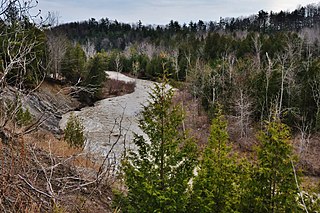
Black Creek is a river in the Golden Horseshoe region of Ontario, Canada. It flows from the city of Vaughan in Regional Municipality of York to the Humber River in Toronto. Black Creek is smaller than most of the waterways in the Greater Toronto Area.

Daylighting is the term for restoration of an originally open-air watercourse which had at some point been diverted below ground back into an above-ground channel. Typically, the rationale behind returning the riparian environment of a stream, wash, or river to a more natural state is to reduce runoff, create habitat for species in need of it, or improve an area's aesthetics. In the UK, the practice is also known as deculverting.

Clear Creek is a stream in northeast Atlanta that is a tributary to Peachtree Creek and part of the Chattahoochee River watershed. It has two main branches, one originating east of the high ground along which Boulevard runs and another to the west originating on the northeast side of downtown Atlanta. The easterly branch of Clear Creek begins in several springs and branches in what are now Inman Park and the Old Fourth Ward. Flowing north, the creek was joined by other branches and springs, including Angier Springs near the end of Belgrade Avenue and the so-called Ponce de Leon Springs, which were “discovered” during railroad construction in the 1860s and gave rise to the eponymous park and avenue.
The Toronto ravine system is one of the most distinctive features of the geography of Toronto, Ontario, Canada. It is a network of deep ravines that form a large urban forest that runs throughout much of the city. For the most part designated as parkland, the ravines are largely undeveloped. Toronto's slogan: "The city within a park" partially stems from the extensive ravine green space.

Superior Creek was a stream draining into Lake Ontario in the former village of Mimico, Ontario, Canada. It was approximately 3 kilometers long, with headwaters near the present intersection of Kipling Avenue and The Queensway. The lower reaches of the creek had become polluted, and were buried in a sewer in 1915. In 1954 citizens of Mimico living in newly built houses near the upper reaches complained that the creek flooded, and lobbied to have the creek replaced by storm sewers, and a study was prepared. According to HTO: Toronto's water from Lake Iroquois to lost rivers to low-flow toilets, the creek was buried around 1965.

Black Hole Creek is a tributary of the West Branch Susquehanna River near Montgomery, in Lycoming County, Pennsylvania, in the United States. It is approximately 8 miles (13 km) long. The stream contains trout. It also is subject to significant increases in temperature downstream of a pond on the grounds of the Allenwood Federal Prison. However, the temperature decreases again after reaching the pond and is somewhat lower at the mouth, but the water at this point is still warmer than at the headwaters.

Dock Creek was a stream draining much of what is now the eastern half of Center City, Philadelphia. It was a tributary of the Delaware River. By 1820, the entire creek had been covered and converted to a sewer. The present-day Dock Street follows the lower course of the stream.

Ashbridge's Bay is a bay and park in Toronto, Ontario, Canada. It is located along Lake Shore Boulevard next to Woodbine Beach in the Beaches. The Martin Goodman Trail and boardwalk run through the park along the bay. The boardwalk runs 3 kilometres (1.9 mi) from Ashbridge's Bay in the west to the R. C. Harris Water Treatment Plant in the east along Lake Ontario. It was once part of the marsh that lay east of Toronto Islands and Toronto Harbour.
Fulton Creek Is a minor tributary which flows into the North Saskatchewan River. Fulton Creek originates within The Meadows area of Edmonton, Alberta. As with other urban Edmonton waterways, with long stretches running through underground culverts, and water volume managed by other urban land uses and for erosion control, Fulton Creek has been labeled a lost creek.

Ashbridge's Creek was a watercourse that flowed in Ashbridge's Bay, between the Don River and Highland Creek. Its headwaters were north of Greenwood and Danforth avenues, making it about 4 kilometres (2.5 mi) long.
Small's Creek was one of the three watercourses that flowed into Small's Pond, a small body of water of several acres in area, located near the intersection of Queen Street and Kingston Road, in Toronto, Ontario. There is a small plain between the shore of Lake Ontario and the bluffs which marked the shore of the larger Glacial Lake Iroquois, Bedrock was shallow on the plain. Smalls Creek, Tomlin's Creek, the other watercourse that drains into Smalls Pond, and Ashbridge's Creek to the east were all small, short watercourses, with their headwaters on that small plain, had each become polluted by the turn of the 20th century, when the regions they flowed through were annexed into the growing city of Toronto.

Smalls Pond was a pond located near Queen Street East and Kingston Road in Toronto, Canada. Some accounts say it was twelve feet deep, others that it was twelve meters deep. While some accounts say it was a natural feature, Jane Fairburn, in "Along the Shore: Rediscovering Toronto's Waterfront Heritage", wrote that gentleman farmer Charles Coxwell Small, owner of 472 acres, dammed a creek than called Serpentine Creek, to form the damm, for the water-power for sawmills.

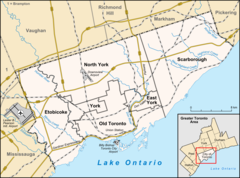
The Toronto waterway system comprises a series of natural and man-made watercourses in the Canadian city of Toronto. The city is dominated by a large river system spanning most of the city including the Don River, Etobicoke Creek, Highland Creek, Humber River, Mimico Creek and Rouge River.
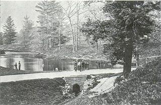
McCaul's Pond was located at the site of Hart House, on the University of Toronto campus. McCaul's Pond was created by damming Taddle Creek in the early 1860s. Increased settlement, and economic activity, had already begun changing the creek from being the clear, free running watercourse early settlers found, so clean it was a breeding ground for salmon, to a polluted watercourse. Damming the creek accelerated the dangers and the pond was drained prior to burying the University's portion of the creek in 1884.

Yellow Creek, is a partially buried south-easterly tributary of the Don River in Toronto. It has also been known at different times as Silver Creek, Sylvan Creek, and also Rosedale Brook. The former source of Yellow Creek begins near Sheppard West station in the Downsview neighbourhood. Most of the creek and its sources are buried underground in storm sewers until they emerge into Avoca Ravine in the Deer Park neighbourhood and continues its way to the Don River.
Wendigo Creek was a short watercourse in Toronto, Ontario, that drains into Grenadier Pond. It was spring fed, like nearby Spring Creek. Its headwaters were north of Bloor Street, near Dundas Street and Laws Street.

Mud Creek, is a mostly buried south-easterly tributary of the Don River in Toronto. It has also been known at different times as Mount Pleasant Brook and Spring Valley Creek.