Tovo di Sant'Agata

Last updated
Tovo di Sant'Agata
Comune
Comune di Tovo di Sant'Agata
Italy provincial location map 2015.svg
Red pog.svg
Tovo di Sant'Agata
Location of Tovo di Sant'Agata in Italy
Coordinates: 46°15′N10°15′E / 46.250°N 10.250°E / 46.250; 10.250 Coordinates: 46°15′N10°15′E / 46.250°N 10.250°E / 46.250; 10.250
Country Italy
Region Lombardy
Province Province of Sondrio (SO)
Area
  Total 11.0 km2 (4.2 sq mi)
Population (Dec. 2004)
  Total 577
  Density 52/km2 (140/sq mi)
Time zone CET (UTC+1)
  Summer (DST) CEST (UTC+2)
Postal code23030
Dialing code 0342
the town Tovo di Sant'Agata Panorama.jpg
the town

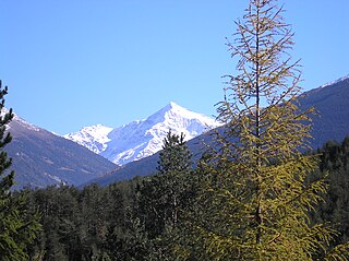
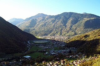
Tovo di Sant'Agata is a comune (municipality) in the Province of Sondrio in the Italian region Lombardy, located about 120 kilometres (75 mi) northeast of Milan and about 30 kilometres (19 mi) northeast of Sondrio. As of 31 December 2004, it had a population of 577 and an area of 11.0 square kilometres (4.2 sq mi). [1]

<i>Comune</i> third-level administrative divisions of the Italian Republic

The comune is a basic administrative division in Italy, roughly equivalent to a township or municipality.

Province of Sondrio Province of Italy

The Province of Sondrio is in the Lombardy region of northern Italy. Its provincial capital is the town Sondrio. As of 2017, it has a population of 181,403.

Italy republic in Southern Europe

Italy, officially the Italian Republic, is a country in Southern and Western Europe. Located in the middle of the Mediterranean Sea, Italy shares open land borders with France, Switzerland, Austria, Slovenia and the enclaved microstates San Marino and Vatican City. Italy covers an area of 301,340 km2 (116,350 sq mi) and has a largely temperate seasonal and Mediterranean climate. With around 61 million inhabitants, it is the fourth-most populous EU member state and the most populous country in Southern Europe.

Tovo di Sant'Agata borders the following municipalities: Edolo, Lovero, Mazzo di Valtellina, Monno, Vervio.

Edolo Comune in Lombardy, Italy

Edolo is a town and comune in the province of Brescia, Lombardy, northern Italy, located in the upper Camonica valley. Edolo is neighbour to the comuni of Corteno Golgi, Incudine, Lovero, Malonno, Monno, Ponte di Legno, Saviore dell'Adamello, Sernio, Sonico, Temù, Tovo di Sant'Agata, Vezza d'Oglio and Vione.

Lovero Comune in Lombardy, Italy

Lovero is a comune (municipality) in the Province of Sondrio in the Italian region Lombardy, located about 120 kilometres (75 mi) northeast of Milan and about 30 kilometres (19 mi) east of Sondrio. As of 31 December 2004, it had a population of 663 and an area of 13.4 square kilometres (5.2 sq mi).

Mazzo di Valtellina Comune in Lombardy, Italy

Mazzo di Valtellina is a comune (municipality) in the Province of Sondrio in the Italian region Lombardy, located about 120 kilometres (75 mi) northeast of Milan and about 30 kilometres (19 mi) northeast of Sondrio. As of 31 December 2004, it had a population of 1,075 and an area of 15.4 square kilometres (5.9 sq mi).

Demographic evolution

Tovo di Sant%27Agata

Related Research Articles

Sardigliano Comune in Piedmont, Italy

Sardigliano is a comune (municipality) in the Province of Alessandria in the Italian region Piedmont, located about 100 kilometres (62 mi) southeast of Turin and about 30 kilometres (19 mi) southeast of Alessandria. As of 31 December 2004, it had a population of 438 and an area of 12.6 square kilometres (4.9 sq mi).

Berbenno di Valtellina Comune in Lombardy, Italy

Berbenno di Valtellina is a comune (municipality) in the Province of Sondrio in the Italian region Lombardy, located about 90 kilometres (56 mi) northeast of Milan and about 9 kilometres (6 mi) west of Sondrio. As of 31 December 2004, it had a population of 4,226 and an area of 35.7 square kilometres (13.8 sq mi).

Castione Andevenno Comune in Lombardy, Italy

Castione Andevenno is a comune (municipality) in the Province of Sondrio in the Italian region Lombardy, located about 90 kilometres (56 mi) northeast of Milan and about 5 kilometres (3 mi) west of Sondrio. As of 31 December 2004, it had a population of 1,545 and an area of 17.1 square kilometres (6.6 sq mi).

Cedrasco Comune in Lombardy, Italy

Cedrasco is a comune (municipality) in the Province of Sondrio in the Italian region Lombardy, located about 90 kilometres (56 mi) northeast of Milan and about 8 kilometres (5 mi) west of Sondrio. As of 31 December 2004, it had a population of 476 and an area of 14.8 square kilometres (5.7 sq mi).

Montagna in Valtellina Comune in Lombardy, Italy

Montagna in Valtellina is a comune (municipality) in the Province of Sondrio in the Italian region Lombardy, located about 100 kilometres (62 mi) northeast of Milan and about 3 kilometres (2 mi) northeast of Sondrio.

Postalesio Comune in Lombardy, Italy

Postalesio is a comune (municipality) in the Province of Sondrio in the Italian region Lombardy, located about 90 kilometres (56 mi) northeast of Milan and about 6 kilometres (4 mi) west of Sondrio. As of 31 December 2004, it had a population of 618 and an area of 10.6 square kilometres (4.1 sq mi).

Rogolo Comune in Lombardy, Italy

Rogolo is a comune (municipality) in the Province of Sondrio in the Italian region Lombardy, located about 80 kilometres (50 mi) northeast of Milan and about 30 kilometres (19 mi) west of Sondrio. As of 31 December 2004, it had a population of 568 and an area of 13.0 square kilometres (5.0 sq mi). Rogolo borders the following municipalities: Andalo Valtellino, Cosio Valtellino, Delebio, Mantello, Pedesina, Premana, Rasura

San Giacomo Filippo Comune in Lombardy, Italy

San Giacomo Filippo is a comune (municipality) in the Province of Sondrio in the Italian region Lombardy, located about 100 kilometres (62 mi) north of Milan and about 45 kilometres (28 mi) northwest of Sondrio, on the border with Switzerland. As of 31 December 2004, it had a population of 453 and an area of 62.1 square kilometres (24.0 sq mi).

Spriana Comune in Lombardy, Italy

Spriana is a comune (municipality) in the Province of Sondrio in the Italian region Lombardy, located about 100 kilometres (62 mi) northeast of Milan and about 6 kilometres (4 mi) north of Sondrio. As of 31 December 2004, it had a population of 101 and an area of 8.2 square kilometres (3.2 sq mi).

Torre di Santa Maria Comune in Lombardy, Italy

Torre di Santa Maria is a comune (municipality) in the Province of Sondrio in the Italian region Lombardy, located about 100 kilometres (62 mi) northeast of Milan and about 8 kilometres (5 mi) north of Sondrio. As of 31 December 2004, it had a population of 884 and an area of 45.5 square kilometres (17.6 sq mi).

Valfurva Comune in Lombardy, Italy

Valfurva is a comune (municipality) in the Province of Sondrio in the Italian region Lombardy, located about 150 kilometres (93 mi) northeast of Milan and about 50 kilometres (31 mi) northeast of Sondrio, in the Alps. As of 31 December 2004, it had a population of 2,725 and an area of 215.9 square kilometres (83.4 sq mi).

Vervio Comune in Lombardy, Italy

Vervio is a comune (municipality) in the Province of Sondrio in the Italian region Lombardy, located about 120 kilometres (75 mi) northeast of Milan and about 30 kilometres (19 mi) northeast of Sondrio, on the border with Switzerland. As of 31 December 2004, it had a population of 230 and an area of 12.6 square kilometres (4.9 sq mi).

Villa di Tirano Comune in Lombardy, Italy

Villa di Tirano is a comune (municipality) in the Province of Sondrio in the Italian region Lombardy, located about 110 kilometres (68 mi) northeast of Milan and about 20 kilometres (12 mi) east of Sondrio, on the border with Switzerland. As of 31 December 2004, it had a population of 2,997 and an area of 24.6 square kilometres (9.5 sq mi).

SantAgata di Militello Comune in Sicily, Italy

Sant'Agata di Militello is a comune (municipality) in the Metropolitan City of Messina in the Italian region Sicily, located about 120 kilometres (75 mi) east of Palermo and about 80 kilometres (50 mi) west of Messina.

San Giovanni la Punta Comune in Sicily, Italy

San Giovanni la Punta is a comune (municipality) in the Metropolitan City of Catania in the Italian region Sicily, located about 160 kilometres (99 mi) southeast of Palermo and about 8 kilometres (5 mi) northeast of Catania.

Mortirolo Pass mountain pass

The Mortirolo Pass (el. 1852 m.) is a high mountain pass in the Alps in Italy. Also known as Passo di Foppa, it connects Mazzo di Valtellina and Val Camonica. The road from Mazzo di Valtellina is one of the most demanding climbs in professional road bicycle racing, having been used in the Giro d'Italia stage race many times.

Sant'Agata may refer to:

Tovo may refer to a pair of Italian municipalities:

References

  1. All demographics and other statistics: Italian statistical institute Istat.