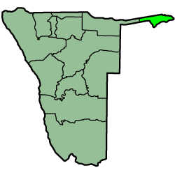
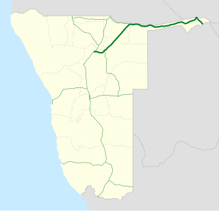
| Trans-Caprivi highway | |
|---|---|
 Map showing the Trans-Caprivi highway connecting Namibia and Zambia | |
| Highway system | |
| Transport in Namibia |

The Trans-Caprivi highway opened in 1999 runs from Rundu, in north eastern Namibia, along the Caprivi Strip to Katima Mulilo on the Zambezi River which forms the border between Namibia and Zambia. The Katima Mulilo Bridge spans the river to the Zambian town of Sesheke from where a recently upgraded paved road runs to Livingstone joining the main southern highway to Lusaka, connecting onwards to the Copperbelt.
Rundu is the capital of the Kavango-East Region, northern Namibia, on the border with Angola on the banks of the Kavango River about 1,000 metres above sea level. The place normally receives an annual average rainfall of 565 millimetres (22.2 in), although in the 2010/2011 rainy season 757 millimetres (29.8 in) were measured.

Namibia, officially the Republic of Namibia, is a country in southern Africa. Its western border is the Atlantic Ocean; it shares land borders with Zambia and Angola to the north, Botswana to the east and South Africa to the south and east. Although it does not border Zimbabwe, less than 200 metres of the Zambezi River separates the two countries. Namibia gained independence from South Africa on 21 March 1990, following the Namibian War of Independence. Its capital and largest city is Windhoek, and it is a member state of the United Nations (UN), the Southern African Development Community (SADC), the African Union (AU), and the Commonwealth of Nations.

Caprivi, or the Caprivi Strip, is a salient of Namibia which is and has been known by various names.
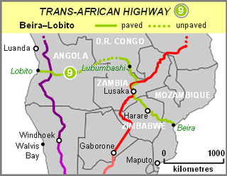
The Trans-Caprivi highway is a section of the Walvis Bay Corridor, a trade route linking land-locked Zambia (and neighbouring countries such as DR Congo, Malawi and Zimbabwe) to the Walvis Bay port on the Atlantic Ocean. An example of the function of the corridor as a trade route is that trucks carry copper ore concentrate from the Dikulushi Mine in South-East DR Congo across Zambia and down the Trans-Caprivi highway to the copper smelter at Tsumeb in Namibia. The refined copper is then exported from Namibian ports.

Walvis Bay, meaning "Whale Bay", is a city in Namibia and the name of the bay on which it lies. The town covers a total area of 29 square kilometres (11 sq mi) of land.

A trade route is a logistical network identified as a series of pathways and stoppages used for the commercial transport of cargo. The term can also be used to refer to trade over bodies of water. Allowing goods to reach distant markets, a single trade route contains long distance arteries, which may further be connected to smaller networks of commercial and noncommercial transportation routes. Among notable trade routes was the Amber Road, which served as a dependable network for long-distance trade. Maritime trade along the Spice Route became prominent during the Middle Ages, when nations resorted to military means for control of this influential route. During the Middle Ages, organizations such as the Hanseatic League, aimed at protecting interests of the merchants and trade became increasingly prominent.

Malawi, officially the Republic of Malawi, is a landlocked country in southeast Africa that was formerly known as Nyasaland. It is bordered by Zambia to the northwest, Tanzania to the northeast, and Mozambique on the east, south and west. Malawi spans over 118,484 km2 (45,747 sq mi) and has an estimated population of 18,091,575. Lake Malawi takes up about a third of Malawi's area. Its capital is Lilongwe, which is also Malawi's largest city; the second largest is Blantyre, the third largest is Mzuzu and the fourth largest is its old capital Zomba. The name Malawi comes from the Maravi, an old name of the Nyanja people that inhabit the area. The country is nicknamed "The Warm Heart of Africa" because of the friendliness of the people.
Although situated in southern Africa, the Trans-Caprivi highway is part of the most northerly paved highway route linking the Atlantic and Indian Oceans. Between the North African coast road running along the Mediterranean Sea from Egypt to Morocco on the one hand (which cannot be driven continuously; the Morocco-Algeria border is closed), and the Trans-Caprivi highway and the roads linking it to the east coast on the other side (a span of about 5700 km[ ambiguous ][ citation needed ]), there are no paved highways crossing the African continent between east and west.

The Indian Ocean is the third-largest of the world's oceanic divisions, covering 70,560,000 km2 (27,240,000 sq mi). It is bounded by Asia on the north, on the west by Africa, on the east by Australia, and on the south by the Southern Ocean or, depending on definition, by Antarctica.

North Africa is a region encompassing the northern portion of the African continent. There is no singularly accepted scope for the region, and it is sometimes defined as stretching from the Atlantic shores of Mauritania in the west, to Egypt's Suez Canal and the Red Sea in the east. Others have limited it to the countries of Algeria, Morocco, and Tunisia, a region that was known by the French during colonial times as "Afrique du Nord" and is known by Arabs as the Maghreb. The most commonly accepted definition includes Morocco, Algeria, Tunisia, Libya, Egypt, and Sudan, the 6 countries that shape the top North of the African continent. Meanwhile, "North Africa", particularly when used in the term North Africa and the Middle East, often refers only to the countries of the Maghreb and Libya. Egypt, being also part of the Middle East, is often considered separately, due to being both North African and Middle Eastern at the same time.

The Mediterranean Sea is a sea connected to the Atlantic Ocean, surrounded by the Mediterranean Basin and almost completely enclosed by land: on the north by Southern Europe and Anatolia, on the south by North Africa and on the east by the Levant. Although the sea is sometimes considered a part of the Atlantic Ocean, it is usually referred to as a separate body of water. Geological evidence indicates that around 5.9 million years ago, the Mediterranean was cut off from the Atlantic and was partly or completely desiccated over a period of some 600,000 years before being refilled by the Zanclean flood about 5.3 million years ago.