Transportation in Thunder Bay, Ontario

Last updated
A boat carrying wood in the harbour Boat In Thunder Bay Harbour Carrying Wood.jpg
A boat carrying wood in the harbour

Transport in Thunder Bay is essential to trade, which has always been the backbone of the economy, beginning with Fort Kaministiquia in 1717. When the area was first settled its many waterways were used by the voyagers and Coureur des bois to trade their goods.

Contents

Thunder Bay has a central location within Canada, and is located in the middle of the Trans-Canada Highway system, crossed by railways, and is the location of the largest outbound port on the St. Lawrence Seaway System [1] and the fifth busiest airport in Ontario by aircraft movements. [2]

Highways

Thunder Bay Expressway Thunder Bay Expressway Looking South At Mountains.jpg
Thunder Bay Expressway

Thunder Bay is located on a unique section of the Trans-Canada Highway system; unlike Western Canada and much of Eastern Canada, there is only one branch of this highway serving the area. As a result, a large volume of trans-Canada truck traffic goes through Thunder Bay.

Trans-Canada Highway 11/17 originates 1 km east of Nipigon and terminates approximately 45 km west of Thunder Bay. The stretch of Highway from 11/17 in Nipigon to Arthur Street in Thunder Bay is designated as the Terry Fox Courage Highway, [3] and between Hodder Avenue and Arthur Street the highway is called the Thunder Bay Expressway. At the intersection of the Harbour Expressway in Thunder Bay, the Trans-Canada designation turns west, with the continuing highway heading south to Minnesota being designated as Highway 61.

Other highways in the city are Highway 102, located between the intersection of Highway 11/17 at Red River Road in the east and the community of Kaministiquia in the west. Highway 61 begins at the intersection of the Harbour Expressway and Highway 11/17 and leads south to the United States border, becoming Minnesota State Highway 61. Highway 589 connects Highway 102 to Dog Lake, located in Gorham and Ware Townships, northeast of the city. The Harbour Expressway is a four-lane highway bisecting the city laterally in the Intercity and Balmoral Park areas. The "expressway" designation of both the Thunder Bay and Harbour expressways has been called into question, as both routes feature multiple lighted intersections, and are not true expressways.

To bypass the urban sprawl in the south end of the city, a new stretch of highway, called the "Shabaqua Highway", [4] was built between 1997 and 2007. [5] It begins at the intersection of the Thunder Bay and Harbour Expressways in Thunder Bay and travels 13 km west to the intersection of Vibert Road and the Trans-Canada in Paipoonge.

City Streets

Thunder Bay is mainly made up of a gridded road network; because it is made up of many smaller communities amalgamated together, many individualized grid systems exist throughout the city. The most notable grids are the ones in older areas of Port Arthur and Fort William, as well as the majority or all of Current River and Westfort. In the case of the Port Arthur grid, it does not run true north–south, instead running parallel to the waterfront. Here, Red River Road functions as the divider of the north and south sections of the area. In Fort William, the intersection of Edward Street and Victoria Avenue is designated as the starting point, and nearly the entire south side is divided into quadrants radiating from the intersection. In neighbourhoods constructed since the 1970s, streets usually do not conform to any grid system, and instead are made up of curvature crescents and cul-de-sacs.

Due to the separate grid and address-numbering systems present throughout the city, major arterial roads are required to change names several times through their courses, in particular those passing through the Intercity area.

Public transit

Public transit has been present in the Thunder Bay area since 1892. Both Port Arthur and Fort William operated streetcars until the late 1940s, when they were replaced by electric trolley buses. When the cities amalgamated in 1970, both transit systems were merged into Thunder Bay Transit, which has exclusively used diesel buses since 1972. Thunder Bay Transit provides 17 routes across the city's urban area with bus frequencies on most routes being between 15 and 45 minutes.

HAGI Transit

The Handicapped Action Group Incorporated operates a door-to-door transit service [6] for seniors and persons who are unable to use City Transit. Users must register with HAGI to use the service, [7] which is funded by the city of Thunder Bay. [8]

Bus terminals

Thunder Bay Transit operates two bus terminals, one in each downtown core. The Ontario Northland intercity bus service stops at 1475 Walsh St. W. [9]

Railway

CP Engines in Thunder Bay CP Engine 1543 Heading South In Port Arthur.jpg
CP Engines in Thunder Bay

Thunder Bay is an important railway hub, served by both the Canadian National and Canadian Pacific Railway. The city is intersected in many places by railway lines, most notably the CN line which runs diagonally through Thunder Bay South and Intercity, cutting off traffic along major arterials. [10]

Major rail yards are located southwest of the airport, south and east of downtown Fort William and immediately south of the East End neighbourhood, and between the city and the waterfront harbour in the intercity area.

Passenger rail service to Thunder Bay ended on 15 January 1990, with the move of Via Rail Canada's The Canadian service to the northern route. [11] The CPR Union Depot (1910) remains in Fort William, with the CNR station (1905) providing tourism related services in Marina Park.

Harbour

Thunder Bay Port is the westernmost port of the Canadian portion of the St. Lawrence Seaway. It is located over 3000 km from the Atlantic Ocean. [12] The port is capable of handling all types of cargoes, and is served by the Canadian National and Canadian Pacific Railways. It has numerous berths allowing for a quick turn-around time. The main cargoes handled at the port are grain, coal, potash, and forest products. [12]

Keefer Terminal is the main cargo handling facility, which has 500,000 square metres of indoor storage area and 6.4 hectares of outdoor storage area. [13] Thunder Bay Terminals Ltd. provides a rail and vessel link for the movement of low sulphur bituminous and lignite coal from western Canada, and is located on McKeller Island. [14]

Grain terminals

Grain elevators. Grain Terminals At Intercity Thunder Bay Harbour Ontario.jpg
Grain elevators.

Thunder Bay is well known for its many grain elevators, dubbed "Castles of Commerce", on its waterfront. Thunder Bay is the second largest grain port in Canada, making it an important part of Canadian grain exports. Sixteen grain elevators are located on the waterfront, however only nine are currently operational. The nine grain elevators have a capacity of 1.4 million tonnes and are capable of handing wheat, durum, coarse grains, oilseeds, feed grains, peas and crops as well as various grain by-products. [15]

History

Abandoned grain elevator Abandoned Grain Elevator Thunder Bay April 2006.jpg
Abandoned grain elevator

Thunder Bay has been a port since the days of the North West Company which maintained a schooner on Lake Superior. Significant navigation came after 1855 with the opening of the canal at Sault Ste. Marie (Soo Locks) which allowed ships coming from the lower lakes to bypass the rapids of the St. Marys River. To facilitate navigation, the federal government dredged the Kaministiquia River from 1873 onwards and built a large breakwater in Thunder Bay beginning in 1884. Thunder Bay Port Authority manages Keefer Terminal built on a 320,000 square metre site on Lake Superior.

Until the 1970s, coal, grain, iron ore and package freight were handled through the port in enormous quantities. Gradually, shipping by train and boat diminished as most package freight is transported by road. The railway's Intermodal freight transport has done away with the costly transshipment of individual goods between boxcars and lake freighters. Combined with loss of grain subsidies (the Crow Rate) and the free trade agreement with the United States, have terminated Thunder Bay's privileged position as a linchpin in Canadian east–west trade. As a result, the city has lost its traditional raison d'être as a break-bulk point, and the city is in economic decline.

Air travel

The city is served by the Thunder Bay International Airport, the fifth busiest airport in Ontario. [2] In 2004, over 600,000 passengers travelled through the airport.[ citation needed ] The airport is serviced by Air Canada Jazz, Westjet, Flair Airlines, Bearskin Airlines, Wasaya Airways, Air Creebec, Skyservice, Thunder Airlines, Wiskair, Air Bravo, Porter Airlines, and NAC Air.

Taxi services

The two major taxi companies in Thunder Bay are Roach's Yellow Taxi and Diamond-Lacey's Taxi. Superior Accessible Taxi operates handicapped accessible taxi services.

A semi at Thunder Bay Harbour Truck At Thunder Bay Waterfront Heading North On Marina Drive.jpg
A semi at Thunder Bay Harbour

Related Research Articles

<span class="mw-page-title-main">Thunder Bay</span> City in Ontario, Canada

Thunder Bay is a city in and the seat of Thunder Bay District, Ontario, Canada. It is the most populous municipality in Northwestern Ontario and the second most populous municipality in Northern Ontario; its population is 108,843 according to the 2021 Canadian Census. Located on Lake Superior, the census metropolitan area of Thunder Bay has a population of 123,258 and consists of the city of Thunder Bay, the municipalities of Oliver Paipoonge and Neebing, the townships of Shuniah, Conmee, O'Connor, and Gillies, and the Fort William First Nation.

Port Arthur was a city in Northern Ontario, Canada, located on Lake Superior. In January 1970, it amalgamated with Fort William and the townships of Neebing and McIntyre to form the city of Thunder Bay.

<span class="mw-page-title-main">Harbourfront, Toronto</span> Neighbourhood in Toronto, Ontario, Canada

Harbourfront is a neighbourhood on the northern shore of Lake Ontario within the downtown core of the city of Toronto, Ontario, Canada. Part of the Toronto waterfront, Harbourfront extends from Bathurst Street in the west, along Queens Quay, with its ill-defined eastern boundary being either Yonge Street or York Street. Its northern boundary is the Gardiner Expressway. Much of the district was former water lots filled in during the early 1900s to create a larger harbour district. After shipping patterns changed and the use of the Toronto harbour declined, the area was converted from industrial uses to a mixed-use district that is mostly residential and leisure.

<span class="mw-page-title-main">Toronto waterfront</span> Shore of Lake Ontario in Toronto, Canada

The Toronto waterfront is the lakeshore of Lake Ontario in the city of Toronto, Ontario, Canada. It spans 46 kilometres between the mouth of Etobicoke Creek in the west and the Rouge River in the east.

<span class="mw-page-title-main">Thunder Bay International Airport</span> Airport in Thunder Bay, Ontario, Canada

Thunder Bay Airport is an airport in the city of Thunder Bay, Ontario, Canada. With 108,130 aircraft movements in 2012, it was the fourth busiest airport in Ontario and the 16th busiest airport in Canada. During the same year, more than 761,000 passengers went through the airport.

<span class="mw-page-title-main">Transportation in Philadelphia</span>

Transportation in Philadelphia involves the various modes of transport within the city and its required infrastructure. In addition to facilitating intracity travel, Philadelphia's transportation system connects Philadelphia to towns of its metropolitan area and surrounding areas within the Northeast megalopolis.

<span class="mw-page-title-main">Ontario Highway 61</span> Ontario provincial highway

King's Highway 61, commonly referred to as Highway 61 and historically known as the Scott Highway, is a provincially maintained highway in the Canadian province of Ontario. The 61-kilometre (38 mi) route connects the Pigeon River Bridge, where it crosses into the United States and becomes Minnesota State Highway 61, with a junction at Highway 11, Highway 17 and the Harbour Expressway in Thunder Bay. The highway forms part of the Lake Superior Circle Tour.

<span class="mw-page-title-main">Union Station Bus Terminal</span> Principal intercity bus terminal for Toronto, Ontario, Canada

The Union Station Bus Terminal is the central intercity bus terminal in Toronto, Ontario, Canada. It is located in Downtown Toronto on the second floor of the south tower of CIBC Square, on the northeast corner of Bay Street and Lake Shore Boulevard. The terminal currently serves GO Transit regional buses as well as Coach Canada, Greyhound Lines and Ontario Northland long-distance bus services, among others. Owned by the provincial Crown agency Metrolinx, the terminal is connected by pedestrian walkways to the adjacent Union Station, Canada's busiest transportation hub.

The Thunder Bay Expressway, originally known as the Lakehead Expressway is a high-capacity at-grade suburban limited-access road around the western side of Thunder Bay in the Canadian province of Ontario. The 15.3 km (9.5 mi) route travels in a generally north–south direction on the city's west side. It is signed as part of Highway 61 at its southern end, and as part of the concurrent route of Highway 11 and Highway 17. The expressway features several at-grade intersections between its southern terminus at Arthur Street West and the Harbour Expressway and its northeastern terminus at Hodder Avenue.

<span class="mw-page-title-main">Harbour Expressway</span> Limited-access highway in Thunder Bay

The Harbour Expressway is a four-lane highway with signalized intersections running the Intercity business district of Thunder Bay, Ontario, Canada.

<span class="mw-page-title-main">Transportation in the San Francisco Bay Area</span> Overview of transportation in the San Francisco Bay Area, California, United States

People in the San Francisco Bay Area rely on a complex multimodal transportation infrastructure consisting of roads, bridges, highways, rail, tunnels, airports, seaports, and bike and pedestrian paths. The development, maintenance, and operation of these different modes of transportation are overseen by various agencies, including the California Department of Transportation (Caltrans), the Association of Bay Area Governments, San Francisco Municipal Transportation Agency, and the Metropolitan Transportation Commission. These and other organizations collectively manage several interstate highways and state routes, eight passenger rail networks, eight trans-bay bridges, transbay ferry service, local and transbay bus service, three international airports, and an extensive network of roads, tunnels, and bike paths.

Transportation in the Canadian city of Toronto forms the hub of the road, rail and air networks in the Greater Toronto Area and much of southern Ontario. There are many forms of transport in the city, including railways, highways, and public transit. Toronto also has an extensive network of bicycle lanes and multi-use trails and paths.

<span class="mw-page-title-main">Thunder Bay Transit</span> Public transit operator in Thunder Bay, Ontario, Canada

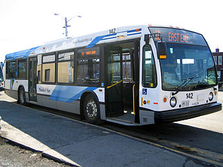
Thunder Bay Transit is the public transit operator in Thunder Bay, Ontario, Canada. It was formed in 1970, after the amalgamation of the cities of Port Arthur and Fort William and their respective transit agencies. Thunder Bay Transit is a member of the Canadian Urban Transit Association.

The city of Calgary, Alberta, has a large transportation network that encompasses a variety of road, rail, air, public transit, and pedestrian infrastructure. Calgary is also a major Canadian transportation centre and a central cargo hub for freight in and out of north-western North America. The city sits at the junction between the "Canamex" highway system and the Trans-Canada Highway.

Transport in Greater Kuala Lumpur includes a road network, a railway network, airports, and other modes of public transport. The Klang Valley is an urban conglomeration consisting of the city of Kuala Lumpur, as well as surrounding towns and cities in the state of Selangor. The Klang Valley has the country's largest airport, the Kuala Lumpur International Airport (KLIA), as well as the country's largest intermodal transport hub and railway station, Kuala Lumpur Sentral.

Transportation in Erie, Pennsylvania includes access to most major forms of transportation, including automobile, bus, train, taxi, airplane, and ship. The city generates income through the transportation industry, including train manufacturing and port operations.

<span class="mw-page-title-main">Downtown Fort William, Ontario</span>

Downtown Fort William, also known as Downtown Thunder Bay South or the South Core, is the urban core of the former city of Fort William, the southern half of Thunder Bay, Ontario. It is centred on Victoriaville Civic Centre, an indoor shopping mall and civic centre built as part of an urban renewal project in the 1980s. It is separated from the Kaministiquia River by the Canadian Pacific Railway line, and its topography is relatively flat.

<span class="mw-page-title-main">Transportation in New Jersey</span> Overview of the transportation in New Jersey

Transportation in New Jersey utilizes a combination of road, rail, air, and water modes. New Jersey is situated between Philadelphia and New York City, two major metropolitan centers of the Boston-Washington megalopolis, making it a regional corridor for transportation. As a result, New Jersey's freeways carry high volumes of interstate traffic and products. The main thoroughfare for long distance travel is the New Jersey Turnpike, the nation's fifth-busiest toll road. The Garden State Parkway connects the state's densely populated north to its southern shore region. New Jersey has the 4th smallest area of U.S. states, but its population density of 1,196 persons per sq. mi causes congestion to be a major issue for motorists.

<span class="mw-page-title-main">South Core, Toronto</span> Neighbourhood in Toronto, Ontario, Canada

South Core is a neighbourhood located in downtown Toronto, Ontario, Canada. The South Core occupies the eastern portions of the Railway Lands. The remodeling and restoration of Union Station and the construction of a new wave of business and condominium towers is central to this area's forecast growth.

"Forecasters expect the downtown population to grow 80 per cent to 130,000 by 2031. With the financial district just to the north and the new high-rise South Core on the other side, Union is right at the centre."

<span class="mw-page-title-main">Thunder Bay Port Authority</span> Port in Ontario, Canada

The Thunder Bay Port Authority is a port authority in Thunder Bay, Ontario, which was created by the Canada Marine Act of 1998. The 19 port authorities created by the act were 19 of the 20 most economically significant ports in Canada. The port is primarily a grain shipping port for Western Canada, with approximately 85% of the cargo tonnage consisting of grain exported to ports around the world. Coal and potash make up most of the remaining cargo of the port, though increasingly wind turbine supplies going to Western Canada are also shipped through the port. In 2019, 429 ships called at the port, with 316 being domestic vessels and 113 foreign vessels. The 2019 shipping season saw an increase of 500,000 tonnes to 9.3 million for the year, with most of the increase coming through the grain sector, though white potash numbers were also up.

References

  1. Port of Thunder Bay official website See first bullet point.
  2. 1 2 Transport Canada TP 1496 – Preliminary aircraft statistics 2006 Archived 2007-09-26 at the Wayback Machine
  3. CBC.ca Archives see: Did You Know? tab
  4. McGuinty Government Secures Partnership To Improve Northern Highways
  5. Highway Opens, TBSource. 17 August 2007. Accessed 18 August 2007.
  6. HAGI Transit Services
  7. HAGI Transit Trip request page, mentioned registration.
  8. City of Thunder Bay – HAGI Transit Operating Agreement. Accessed 11 September 2008.
  9. "Station Locator | Ontario Northland".
  10. Yahoo Maps This satellite image from 2002 captured a CN train crossing Memorial Avenue. Note the two city buses in the northbound lanes south of the crossing.
  11. SOR/89-488 S III (2)(c) accessed 5 June 2007
  12. 1 2 About Thunder Bay Port
  13. Keefer Intermodal
  14. Thunder Bay Terminals Ltd
  15. Grain Terminals