Tredethy

Last updated

Tredethy
Tredethy House - geograph.org.uk - 5676013.jpg
Tredethy House
Location St Mabyn, Cornwall, England
Coordinates 50°30′49″N4°44′07″W / 50.51371°N 4.73533°W / 50.51371; -4.73533
Listed Building – Grade II
Official nameTredethy Country House Hotel
Designated16 November 2010
Reference no. 1327967
Cornwall UK location map.svg
Red pog.svg
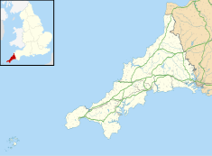
Location of Tredethy in Cornwall
Wood at Tredethy Helland Bridge, a "Stick Insect" at Tredethy - geograph.org.uk - 222558.jpg
Wood at Tredethy

Tredethy is a house and estate in the civil parish of St Mabyn, Cornwall, UK, at Grid reference SX 06 71. It occupies seven acres and is one of a number of small manor houses in the parish all built in the 16th and 17th centuries. The house was extensively restored in 1892 by the prominent Cornish architect Silvanus Trevail. [1]

This was the seat of the Rev. Charles Peters (1690–1774), a Hebrew scholar. [2]

Later it became the home of Prince Chula Chakrabongse of Thailand who married Elizabeth Hunter, an English woman in 1938. Their daughter, Mom Rajawongse Narisa Chakrabhongse, was born in 1956. [3] [4] They lived at Tredethy in the 1940s and 1950s. [5] At Bodmin there is an ornate granite drinking bowl which serves the needs of thirsty dogs at the entrance to Bodmin's Priory car park which was donated by Prince Chula. [6] There is a similar granite drinking bowl at Mitchem’s Corner in Cambridge, donated in 1934 in memory of Prince Chula’s dog called Tony.

In the 1960s Tredethy was converted to a hotel with 11 en-suite bedrooms. [7]
Related Research Articles

<span class="mw-page-title-main">Bodmin</span> Town in east-central Cornwall, England

Bodmin is a town and civil parish in Cornwall, England, United Kingdom. It is situated south-west of Bodmin Moor.

<span class="mw-page-title-main">Bodmin Moor</span> Granite moorland in northeast Cornwall, England

Bodmin Moor is a granite moorland in north-eastern Cornwall, England, United Kingdom. It is 208 square kilometres (80 sq mi) in size, and dates from the Carboniferous period of geological history. It includes Brown Willy, the highest point in Cornwall, and Rough Tor, a slightly lower peak. Many of Cornwall's rivers have their sources here. It has been inhabited since at least the Neolithic era, when early farmers started clearing trees and farming the land. They left their megalithic monuments, hut circles and cairns, and the Bronze Age culture that followed left further cairns, and more stone circles and stone rows. By medieval and modern times, nearly all the forest was gone and livestock rearing predominated.

<span class="mw-page-title-main">North Cornwall</span> Area of Cornwall, England

North Cornwall is an area of Cornwall, England, United Kingdom. It is also the name of a former local government district, which was administered from Bodmin and Wadebridge 50.516°N 4.835°W. Other towns in the area are Launceston, Bude, Padstow, and Camelford.

<span class="mw-page-title-main">St Columb Major</span> Town in Cornwall, England

St Columb Major is a town and civil parish in Cornwall, England, United Kingdom. Often referred to locally as St Columb, it is approximately seven miles (11 km) southwest of Wadebridge and six miles (10 km) east of Newquay The designation Major distinguishes it from the nearby settlement and parish of St Columb Minor on the coast. An electoral ward simply named St Columb exists with a population at the 2011 census of 5,050. The town is named after the 6th-century AD Saint Columba of Cornwall, also known as Columb.

<span class="mw-page-title-main">Kelly Rounds</span> Iron Age hillfort in Cornwall, England

Kelly Rounds, or Castle Killibury is an Iron Age hill fort in Cornwall, England, United Kingdom. It is situated beside the A39 trunk road approximately two miles east of Wadebridge.

<span class="mw-page-title-main">St Mabyn</span> Human settlement in England

St Mabyn is a civil parish and village in Cornwall, England, United Kingdom. The village is situated three miles (5 km) east of Wadebridge. The parish includes a hamlet called Longstone to the east and many small manor houses, including Tregarden, Tredethy, Helligan Barton and Colquite, all built in the 16th and 17th centuries. The area of the parish is 4,101 acres (16.60 km2).

<span class="mw-page-title-main">Blisland</span> Human settlement in England

Blisland is a village and civil parish in Cornwall, England, United Kingdom. It is approximately five miles northeast of Bodmin. According to the 2001 census, the parish had a population of 565. This had increased to 608 at the 2011 census.

<span class="mw-page-title-main">Mabyn</span> Medieval Cornish saint

Mabyn, also known as Mabena, Mabon, etc., was a medieval Cornish saint. According to local Cornish tradition she was one of the many children of Brychan, king of Brycheiniog in Wales in the 5th century. The village and civil parish of St Mabyn is named for her, and the local St Mabyn Parish Church is dedicated to her.

<span class="mw-page-title-main">Tregarden</span> Grade II* listed large house in St Mabyn, Cornwall, England

Tregarden is a Grade II* listed large house built by the Barrett family in the late 16th century in the parish of St Mabyn, Cornwall, England.

Trethevy is a hamlet in north Cornwall, England, United Kingdom.

<span class="mw-page-title-main">Helland</span> Human settlement in England

Helland is a civil parish and village in Cornwall, England, United Kingdom. It is situated 2+12 miles (4.0 km) north of Bodmin. The meaning of the name Helland is unclear: it is possible that the origin is in Cornish hen & lan. The original dedication of the church is unknown but St Helena is now recognised as the patron.

<span class="mw-page-title-main">St Breward</span> Civil parish and village in Cornwall, England

St Breward is a civil parish and village in Cornwall, England, United Kingdom. It is on the western side of Bodmin Moor, about 6 miles (10 km) north of Bodmin. At the 2011 census the parish population including Cooksland and Fentonadle was 919.

<span class="mw-page-title-main">St Mabyn Church of England Primary School</span> Academy in St Mabyn, Cornwall, England

St Mabyn C of E Primary School is a Church of England Primary School with academy status located in the village of St Mabyn between Bodmin and Wadebridge in Cornwall, England, UK. The school educates boys and girls between the ages of four and eleven and has 62 pupils with three mixed age classes. The school federated with St Tudy C of E Primary School in January 2010 with Karen Holmes as joint head. It formed part of the Saints Way Multi Academy Trust, until 2022 when it became part of St Barnabas Multi-Academy Trust.

<span class="mw-page-title-main">Chula Chakrabongse</span> Member of the Thai royal family

Chula Chakrabongse, His Royal Highness Prince Chula Chakrabongse was a member of the family of the Chakri dynasty of Thailand and of the House of Chakkraphong. He was the only child of Prince Chakrabongse Bhuvanath and his Russian wife Catherine Desnitski. He was a grandson of King Chulalongkorn.

<span class="mw-page-title-main">Withiel</span> Human settlement in England

Withiel is a civil parish and village in mid Cornwall, England, United Kingdom. The parish of Withiel is between the parishes of St Breock, Lanivet, Roche and St Wenn. The name Withiel comes from the Cornish word Gwydhyel, meaning "wooded place". The parish contains the hamlets of Withielgoose, Retire and Tregawne; the parish had a total population of about 300 in 1824.

<span class="mw-page-title-main">St Mabyn Parish Church</span> Church

St Mabyn Church is a Grade I listed late 15th-century Church of England parish church in St Mabyn, Cornwall, United Kingdom. The church is dedicated to Saint Mabyn or Mabena, who was regarded in local tradition as one of the many children of Brychan, a Welsh saint and King of Brycheiniog in the 5th century.

<span class="mw-page-title-main">Launceston, Cornwall</span> Town in Cornwall, England

Launceston is a town, ancient borough, and civil parish in Cornwall, England, United Kingdom. It is 1 mile (1.6 km) west of the middle stage of the River Tamar, which constitutes almost the entire border between Cornwall and Devon. The landscape of the town is generally steep particularly at a sharp south-western knoll topped by Launceston Castle. These gradients fall down to the River Kensey and smaller tributaries.

<span class="mw-page-title-main">Narisa Chakrabongse</span> English activist and publisher

Narisa Chakrabongse is a writer, publisher, and environmental activist. The only daughter of Prince Chula Chakrabongse, and the only granddaughter of Prince Chakrabongse and his Ukrainian wife Katerina Desnitskaya, a great-granddaughter of the Siamese King Rama V the Great. Her official title is Mom Rajawongse.

<span class="mw-page-title-main">Outline of Cornwall</span> Overview of and topical guide to Cornwall

The following outline is provided as an overview of and topical guide to Cornwall: Cornwall – ceremonial county and unitary authority area of England within the United Kingdom. Cornwall is a peninsula bordered to the north and west by the Celtic Sea, to the south by the English Channel, and to the east by the county of Devon, over the River Tamar. Cornwall is also a royal duchy of the United Kingdom. It has an estimated population of half a million and it has its own distinctive history and culture.

Presented below is an alphabetical index of articles related to Cornwall:

References

  1. "Tredethy Country House Hotel - St Mabyn - Cornwall - England | British Listed Buildings". britishlistedbuildings.co.uk. 2013. Retrieved 18 May 2013.
  2. English Heritage (2013). "Tredethy Country House Hotel - St Mabyn - Cornwall - England | British Listed Buildings". britishlistedbuildings.co.uk. Retrieved 6 February 2013.
  3. Soravij. "Chakrabongse" . Retrieved 24 May 2009.
  4. HRH Prince Chula CHAKRABONGSE
  5. "New Zealand Cornish Association newsletter" (PDF). Archived from the original (PDF) on 13 September 2012. Retrieved 24 May 2009.
  6. "New Zealand Cornish Association newsletter" (PDF). Archived from the original (PDF) on 13 September 2012. Retrieved 24 May 2009.
  7. "Grade II listed Country House Hotel in Cornwall to market" . Retrieved 25 April 2021.

50°30′50″N4°44′06″W / 50.514°N 4.735°W / 50.514; -4.735