Trefin

Last updated

Trefin
Trefin.JPG
Pembrokeshire UK location map.svg
Red pog.svg
Trefin
Location within Pembrokeshire
Population216 
OS grid reference SM8230
Community
  • Llanrhian
Principal area
Country Wales
Sovereign state United Kingdom
Post town Haverfordwest
Postcode district SA62
Dialling code 01348
Police Dyfed-Powys
Fire Mid and West Wales
Ambulance Welsh
UK Parliament
Senedd Cymru – Welsh Parliament
List of places
UK
Wales
Pembrokeshire
51°56′57″N5°08′43″W / 51.94917°N 5.14528°W / 51.94917; -5.14528

Trefin (Welsh standardised:Tre-fin) [lower-roman 1] , formerly anglicised as Trevine, [2] [3] [4] [5] is a village in North Pembrokeshire, south-west Wales. The village lies within the parish and community of Llanrhian, which has a significant Welsh-speaking population. [6]

Contents

Etymology

The name "Trefin" possibly derives from "Tref" meaning farmstead, and "Ddyn" meaning high ground. [7]

History

The Mill at Aberfelin Water mill at Aber Draw - geograph.org.uk - 53824.jpg
The Mill at Aberfelin

Trefin was settled in the medieval period, around the 12th–13th centuries, [8] having an overall linear arrangement and faint traces of an open-field system. Its earliest inhabitants were of English or Flemish origin. [7] [8]

The settlement had links with the estate of the ecclesiastical lordship of St Davids. [9] The Archdruid Crwys, who was born in Craig Cefn Parc, Glamorganshire, had links to the village, with the historic mill at nearby Aberfelin being the subject of his poem Melin Trefin. [10] Some of Trefin's old village cottages and the old mill's remains date back to the 15th century. [9]

The medieval mill, built for use by the bishops in and located in a rocky cove, was used for roughly 500 years by the local populace until 1918 when it was closed due to cheaper wheat imports from abroad impacted the mill's production. [7] [11] [12] When operating, the wheat at the mill was milled to produce flour for bread and barley was ground into winter feed for livestock. [11]

From the 1800s, most of the village was rebuilt with a mix of early 1900s cottages and larger Victorian homes built for "sea captains". The other main industry during this period alongside farming and shipping, were the mechanised slate quarries near the coast, expanded in the 1860s, with its resources exported from Porthgain's port. [7] [8]

Two chapels were built in the village. The first the Trefin Calvinistic Methodist Chapel built in 1786 (rebuilt in 1834), became a centre for the Calvinistic Methodist Church in Wales and was restored in 1936. [7] [13] The other chapel, the Baptist Chapel was built in 1840, rebuilt in around 1870 and served as a branch of Croesgoch. [7] [14]

By the 1900s cheap grain was being imported from overseas and milled in larger mills in towns and cities, leading to the closure of Aberfelin mill in 1918. The mill stones remain in the ruins of the roofless mill. [15]

The historic centre of the village was designated as a Conservation Area in 1997. [8]

Community

Trefin is surrounded by the Irish Sea and on the Pembrokeshire Coast Path, [9] between Porthgain and Abercastle. It is on the route of the Strumble Shuttle bus service, part of the Pembrokeshire Greenways public transport service. Carreg Samson, a Neolithic burial chamber is located nearby, between the village and Abercastle. [9] Trefin lies within the Pembrokeshire Coast National Park, [8] the only coastal area included in the National parks of the United Kingdom.

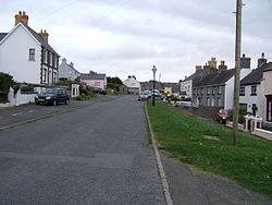
Trefin is a small village of around 130 people, and houses a weaving centre, The Mill cafe, two chapels (both now closed), a pub The Ship Inn, a hostel 'Old School Hostel' as well as holiday accommodation. [9] Nearby villages include Llanrhian, Abercastle, Porthgain, Mathry, Square and Compass, Penparc and Croesgoch. The village is between Fishguard and St Davids. [16]

Notable people

Notes

  1. 1 2 Under the Welsh Language Commissioner's standardisation of Welsh place names, the settlement is to be written as "Tre-fin" in Welsh, although "Trefin" may still be used in Welsh-language sources. [1]

Related Research Articles

<span class="mw-page-title-main">Tywyn</span> Small coastal town in Gwynedd, Wales

Tywyn, formerly spelled Towyn, is a town, community, and seaside resort on the Cardigan Bay coast of southern Gwynedd, Wales. It was previously in the historic county of Merionethshire. It is famous as the location of the Cadfan Stone, a stone cross with the earliest known example of written Welsh, and the home of the Talyllyn Railway.

<span class="mw-page-title-main">Llangeitho</span> Village in Ceredigion, Wales

Llangeitho is a village and community on the upper River Aeron in Ceredigion, Wales, about four miles west of Tregaron and 11 kilometres (7 mi) north of Lampeter. Its population of 874 in 2001 fell to 819 at the 2011 census.

<span class="mw-page-title-main">Frongoch</span> Human settlement in Wales

Frongoch is a village located in Gwynedd, Wales. It lies close to the market town of Bala, on the A4212 road.

<span class="mw-page-title-main">Walton East</span> Human settlement in Wales

Walton East is a small rural village and parish established around a church at least as early as Norman times. It is 2 miles (3.2 km) southwest of Llys y Fran and 1+12 miles (2.4 km) north of Clarbeston Road and in Wiston community in Pembrokeshire, Wales.

<span class="mw-page-title-main">Upper Boat</span> Human settlement in Wales

Upper Boat is a village on the southernmost outskirts of the town of Pontypridd, within the electoral ward of Hawthorn, Rhondda Cynon Taf, Wales, and comprises part of the Treforest Industrial Estate. Historically part of Glamorgan, it fell within the parish of Eglwysilan.

<span class="mw-page-title-main">Mathry</span> Human settlement in Wales

Mathry is a village, community and parish in Pembrokeshire, Wales. The hilltop village is 6 miles (9.7 km) southwest of Fishguard, close to the A487 road between Fishguard and St David's.

<span class="mw-page-title-main">Croes-goch</span> Human settlement in Wales

Croes-goch is a village in North Pembrokeshire, West Wales. It is situated on the A487 between Fishguard and St David's. It lies some five miles northeast of St Davids on the junction of the A487 St Davids to Fishguard road with the B4330 Llanrhian to Haverfordwest. The village, which has a population of about 400, lies within Llanrhian Community Council and lies two miles south of the Pembrokeshire Coast National Park.

<span class="mw-page-title-main">Llithfaen</span> Village in northwest Wales

Llithfaen is a village on the northern coast of the Llŷn Peninsula in Gwynedd, Wales, in the historic county of Caernarfonshire. It is within the community of Pistyll.

<span class="mw-page-title-main">Woodstock, Pembrokeshire</span> Village in Pembrokeshire, Wales

Woodstock is a rural village in the southern foothills of the Preseli Mountains in the community and parish of Ambleston, Pembrokeshire, Wales. There is a built-up area on the B4329 former turnpike, and another down a side-road, close to, but with no road access to Llys y Fran reservoir.

<span class="mw-page-title-main">Llanrhian</span> Human settlement in Wales

Llanrhian is a small village, community and parish in Pembrokeshire in west Wales, near the coast, south of Porthgain village. The community of Llanrhian includes the settlements of Llanhowell, Croesgoch, Portheiddy, Porthgain and Trefin. The village church is St Rhian’s and is of medieval origin. The village is in the Pembrokeshire Coast National Park.

<span class="mw-page-title-main">Llanfechell</span> Village in Anglesey, Wales

Llanfechell is a village in Anglesey, Wales. It is the largest of several small villages and dispersed settlements that make up Mechell Community Council area. It is 11 miles (18 km) east of Holyhead, and 5.6 miles (9 km) west of Amlwch, in the north of the island.

<span class="mw-page-title-main">Caerfarchell</span> Human settlement in Wales

Caerfarchell is a small village in Pembrokeshire, Wales, 3 miles northeast of St Davids, close by the A487 road. It is in the community of St Davids and the Cathedral Close.

<span class="mw-page-title-main">Penderyn, Rhondda Cynon Taf</span> Village in Rhondda Cynon Taf, Wales

Penderyn is a rural village in the Cynon Valley, Rhondda Cynon Taf, Wales, located near Hirwaun.

<span class="mw-page-title-main">Melin-y-Coed</span> Human settlement in Wales

Melin-y-Coed is a small rural village in the county of Conwy, Wales.. The earliest surviving building in the village is Cyffdy Hall, built in 1596.

<span class="mw-page-title-main">Beulah Calvinistic Methodist Chapel</span> Church

Beulah Calvinistic Methodist Chapel, also known locally as "The Round Chapel" and in Welsh as "Capel y Groes", is a Grade II*-listed building in Margam, Port Talbot, Wales. It originally built in the mid-nineteenth century and had to be dismantled and moved in 1974 to make way for the new M4 motorway.

<span class="mw-page-title-main">Mechell, Anglesey</span> Community in Anglesey, Wales

Mechell is a community in the north of the Isle of Anglesey, Wales. Llanfechell is the largest village within the community area. Tregele, Llanfflewyn, Mynydd Mechell, Bodewryd, Rhosbeirio and Carreglefn have a more dispersed settlement pattern. The antiquity of these settlements is shown by the presence of 6 medieval churches and some 16 more ancient sites dating back into prehistory.

<span class="mw-page-title-main">Treffynnon, Pembrokeshire</span> Human settlement in Wales

Treffynnon is a hamlet of about twenty houses located in the community of Brawdy, between St Davids and Fishguard, about a mile inland from the A487 at Croesgoch in Pembrokeshire.

<span class="mw-page-title-main">Penparc, Pembrokeshire</span> Human settlement in Wales

Penparc is a village in the community of Llanrhian, Pembrokeshire, Wales. Located near Trefin and Croesgoch, the village also includes the settlement of Square and Compass to the immediate east. The village composes of multiple housing estates, two holiday parks and a garage. The village is located off the A487, which runs from St Davids to Fishguard. The village is also served by a bus service connecting Haverfordwest with Fishguard via St Davids. The nearest church is in Mathry.

References

  1. "List of Standardised Welsh Place-names". welshlanguagecommissioner.wales. Retrieved 24 August 2022.
  2. "Trefin". www.britishplacenames.uk. Retrieved 24 August 2022.
  3. "Tre-fin Village (406363)". Coflein. RCAHMW . Retrieved 24 August 2022.
  4. "Trefin, Pembrokeshire (Sir Benfro) (or Trevine)". Ordnance Survey GetOutside.
  5. "Trefin". Ordnance Survey.
  6. "Welsh speakers by electoral division, 2011 Census". statswales.gov.wales. 27 March 2011. W05000421: Llanrhian 42.1
  7. 1 2 3 4 5 6 "Trefin Chapel". National Churches Trust. Retrieved 24 August 2022.
  8. 1 2 3 4 5 Trefin - Conservation Area Proposals (PDF). Pembrokeshire Coast National Park Authority. 12 October 2011. p. 7.
  9. 1 2 3 4 5 6 7 "Trefin, Pembrokeshire, Wales - Visit Pembrokeshire". www.visitpembrokeshire.com. Retrieved 24 August 2022.
  10. "Cerys names baby after home". 19 August 2003. Retrieved 6 July 2016 via bbc.co.uk.
  11. 1 2 "Trefin Mill, Pembrokeshire". Peoples Collection Wales. Retrieved 24 August 2022.
  12. "Aberfelin Corn Mill, Near Trefin (40225)". Coflein. RCAHMW . Retrieved 24 August 2022.
  13. "Trefin Chapel (welsh Calvinistic Methodist), Ffordd-yr-afon, Trefine, Mathry (11088)". Coflein. RCAHMW . Retrieved 24 August 2022.
  14. "Elim Capel Bach Baptist Sunday School;trefin;trevine, Ffordd-y-felin, Trefin;trevine (11087)". Coflein. RCAHMW . Retrieved 24 August 2022.
  15. "Geograph:: Ruins of Trefin Mill/Melin Trefin (C) Pauline E" . Retrieved 6 July 2016.
  16. "Trefin Cottages | VisitWales". www.visitwales.com. Retrieved 24 August 2022.
  17. "Richard, Thomas (1783 - 1856), Calvinistic Methodist minister". Dictionary of Welsh Biography . National Library of Wales.