Williamston is a town in Martin County, North Carolina, United States. The population was 5,511 at the 2010 census. It is the county seat of Martin County., and is located in North Carolina's Inner Banks region. The closest major city is Greenville, approx. 28 mi to the southwest.

Atka Island is the largest island in the Andreanof Islands of the Aleutian Islands of Alaska. The island is 50 miles (80 km) east of Adak Island. It is 65 miles (105 km) long and 2–20 miles (3–30 km) wide with a land area of 404.6 square miles (1,048 km2), making it the 22nd largest island in the United States. The northeast of Atka Island contains the Korovin volcano which reaches a peak of 5,030 feet (1,533 m). Oglodak Island is located 3.4 miles off Cape Kigun, Atka's westernmost point.

Churchend is a village in South Gloucestershire, England, near Yate. It is part of the civil parish of Eastington.

Kalagi is a town located in the Western Division of the Gambia.
English Lake Provincial Park is a provincial park in British Columbia, Canada. Located near Revelstoke, British Columbia, English Lake Provincial Park has an area of 337 hectares.

Gibson's Hill or Corcreeny is a small village in the townland of Corcreeny in County Down, Northern Ireland, about 1.5 km from Lurgan. It lies on the main Lurgan to Gilford road. In the 2001 Census it had a population of 186 people. It is within the Craigavon Borough Council area.

Area codes 609 and 640 serve telephones in central New Jersey, including the cities of Trenton, Princeton, Hamilton, and southeastern parts of the state and the Jersey Shore, including Atlantic City and Long Beach Island. In terms of geographic coverage, it is the largest in the state of New Jersey.

The Celtic Trail is a network of dedicated cycle routes in the National Cycle Network, crossing West, South and Mid Wales, and covering 377 miles in total. It is divided into east and west sections. The west section links Pembroke and Fishguard on the west coast to Swansea, and the east section covers the area from Swansea to Chepstow, Abergavenny and Hay-on-Wye in the east. It is largely traffic free but sections along the route are still being upgraded and improved. In some places there is a choice of a low-level route, or a high-level route for mountain bikes.

Area code 856 is an area code located in the U.S. state of New Jersey created in 1999 by a split of area code 609. It covers southwestern New Jersey, especially the Camden/Cherry Hill and Vineland areas, as well as a very small part of Willingboro Township, along with the western part of Burlington County, while 609 covers the rest of Willingboro and the areas to the north and east. 856 is virtually coextensive with the New Jersey side of the Philadelphia metropolitan area.

The A337 road is a road in southern England that runs from the M27 motorway in Hampshire to Christchurch in Dorset.
German submarine U-337 was a Type VIIC U-boat of Nazi Germany's Kriegsmarine during World War II.

South Ottawa Township is located in LaSalle County, Illinois. As of the 2010 census, its population was 8,290 and it contained 3,609 housing units.
WGTD is a radio station licensed to Kenosha, Wisconsin, serving the Racine/Kenosha area. Owned by Gateway Technical College, the station affiliates with Wisconsin Public Radio, and airs WPR's "NPR News and Classical Network", consisting of classical music and news and talk programming, with some local programming and Kenosha-focused newscasts programmed locally.

Ampress Works Halt was a halt station on the Lymington Branch Line which, between 1956 and 1989, served the Wellworthy engineering works near Lymington in Hampshire, England. Sited near the bridge over the A337 Lymington to Brockenhurst road, the station closed when the engineering works ceased operation. The station never appeared in any public timetable.
Hillsea Point Rock is an area of the English Channel located 0.5 nm south-east of Hillsea Point, Devon. It consists of seven or eight pinnacles ranging in depth between 25 metres on the sea bed and 2 metres at the surface
The West Branch Pleasant River is a 36.1-mile-long (58.1 km) tributary of the Piscataquis River in Piscataquis County, Maine. From a location north of Fourth West Branch Pond in Shawtown, the river runs about 18 miles (29 km) counterclockwise around the White Cap Mountain massif, then about 18 miles (29 km) southeast to its confluence with the East Branch of the Pleasant River in Brownville.

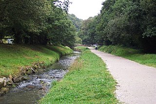
The St Austell River properly known as the River Vinnick, but historically called The White River, is a 12 kilometres (7.5 mi) long river located in south Cornwall, England, United Kingdom. 50.337°N 4.793°W. The river has also been known as the "red river" due to tin streaming and mining activity upstream.
German submarine U-609 was a Type VIIC U-boat built for Nazi Germany's Kriegsmarine for service during World War II. She was laid down on 7 April 1941 by Blohm & Voss, Hamburg as yard number 585, launched on 23 December 1941 and commissioned on 12 February 1942 under Oberleutnant zur See Klaus Rudloff.

Penpont Water is a small river in east Cornwall, United Kingdom. It is a tributary of the River Inny joining it at Two Bridges.


