Related Research Articles
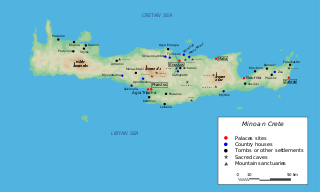
The Minoan civilization was a Bronze Age culture which was centered on the island of Crete. Known for its monumental architecture and its energetic art, it is often regarded as the first civilization in Europe.
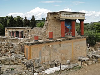
Knossos is a Bronze Age archaeological site in Crete. The site was a major center of the Minoan civilization and is known for its association with the Greek myth of Theseus and the minotaur. It is located on the outskirts of Heraklion, and remains a popular tourist destination.
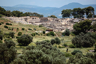
Phaistos ), also transliterated as Phaestos, Festos and Latin Phaestus, is a Bronze Age archaeological site at modern Faistos, a municipality in south central Crete. It is notable for the remains of a Minoan palace and the surrounding town.

Pyrgos is an archaeological site of the Minoan civilization near Myrtos in the municipality of Ierapetra on the south coast of Crete. Pyrgos provides evidence of settlements along the southern Ierapetra Isthmus. This site has had a long history due to its valuable location and geography. It is located close to the Myrtos valley and has a harbor with a nearby mountain range providing its protection. The settlement includes a courtyard, many rooms, a country house and a tomb.

Palaikastro or Palekastro, with the Godart and Olivier abbreviation PK, is a thriving town, geographic heir to a long line of settlements extending back into prehistoric times, at the east end of the Mediterranean island Crete. The Kallikratis Programme implemented starting 2011 made the town into a local community under jurisdiction of the next-highest levels, chained as follows: municipal unit Itanos, municipality (demos) Sitia, regional unit Lasithi, region (periphereia) Crete.

Gortyn, Gortys or Gortyna is a municipality, and an archaeological site, on the Mediterranean island of Crete 45 km (28 mi) away from the island's capital, Heraklion. The seat of the municipality is the village Agioi Deka. Gortyn was the Roman capital of Creta et Cyrenaica. The area was first inhabited around 7000 BC.

Mount Ida, known variously as Idha, Ídhi, Idi, and Ita, is the highest mountain on the island of Crete, with an elevation of 2,456 metres (8,058 ft). It has the highest topographic prominence of any mountain in Greece. A natural park which includes Mount Ida is a member of UNESCO's Global Geoparks Network.


Psychro Cave is an ancient Minoan sacred cave in Lasithi plateau in the Lasithi district of eastern Crete. Psychro is associated with the Diktaean Cave, one of the putative sites of the birth of Zeus. Other legends place Zeus' birthplace as Idaean Cave on Mount Ida. According to Hesiod, Theogony, Rhea gave birth to Zeus in Lyctus and hid him in a cave of Mount Aegaeon. Since the late nineteenth century the cave above the modern village of Psychro has been identified with Diktaean Cave, although there are other candidates, especially a cave above Palaikastro on Mount Petsofas.
Hagia Triada is a Minoan archaeological site in Crete. The site includes the remains of an extensive settlement as well as a large structure known as the Royal Villa. It is located in the Mesara Plain near the Palace of Phaistos, with which it appears to have had close political and economic ties. Excavations at Hagia Triada have provided crucial evidence concerning Minoan everyday life. Notable finds include the Hagia Triada sarcophagus, the "Harvester Vase", and the largest cache of Linear A tablets found at any Minoan site.

Amnisos, also Amnissos and Amnisus, is the current but unattested name given to a Bronze Age settlement on the north shore of Crete that was used as a port to the palace city of Knossos. It appears in Greek literature and mythology from the earliest times, but its origin is far earlier, in prehistory. The historic settlement belonged to a civilization now called Minoan. Excavations at Amnissos in 1932 uncovered a villa that included the "House of the Lilies", which was named for the lily theme that was depicted in a wall fresco.

Phourni is the archaeological site of an ancient Minoan cemetery in Crete, established in 2400 BC and lasted until 1200 BC. Phourni is Greek for "furnace, oven" and the name of the hill on which the cemetery is located. Phourni is located at 70100 Epano Archanes, Heraklion, Greece—located on a hill in north-central Crete. Phourni can be seen from Mount Juktas. It is a small hill situated northwest of Archanes, between Archanes and Kato Archanes. Phourni is reachable from a signed scenic path that starts at Archanes. It was an important site for Minoan burials. The burials consistently and proactively engaged the community of the Minoans. The largest cemetery in the Archanes area was discovered in 1957 and excavated for 25 years by Yiannis Sakellarakis, beginning in 1965. The 6600 sq m cemetery includes 26 funerary buildings of varying shapes and sizes. The necropolis of Phourni is of primary importance, both for the duration of its use and for the variety of its funerary monuments. All the pottery and much of the skeletal material was collected, unlike many other pre-palatial tombs. The cemetery was founded in the Ancient Minoan IIA, and continued to be used until the end of the Bronze Age. The occupation reached its peak during the Middle Minoan AI, just before the palaces of Knossos and Malia appeared. The proximity of Archanes to the important religious centres of Mount Iuktas probably contributed to the prominence of the site.
Apesokari is the archaeological site of an ancient Minoan cemetery. It is also a modern village with a population of 103 (2011) and is built at 155 m above sea level. It is in the municipality of Gortyna in the south of Heraklion regional unit, Greece.
Odigitria is the archaeological site of an ancient Minoan religious complex including two tholos tombs located near the modern Odigitria Monastery in the Asterousia mountains of southern Crete.

Hagia Photia is an archaeological site of a fortified ancient Minoan building on eastern Crete. Sitia lies five kilometers to the west.
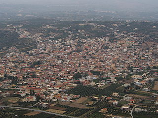
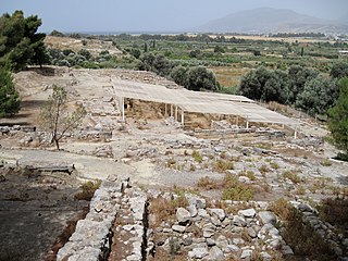
Archanes is a former municipality in the Heraklion regional unit, Crete, Greece. Since the 2011 local government reform it is part of the municipality Archanes-Asterousia, of which it is a municipal unit. The municipal unit has an area of 31.516 km2 (12.168 sq mi). Population 5,042 (2011). It is also the archaeological site of an ancient Minoan settlement in central Crete. The discovery of ancient roads leading from Archanes to Juktas, Anemospilia, Xeri Kara and Vathypetro indicate that Archanes was an important hub in the region during Minoan times. Archaeological evidence indicates that ancient Archanes spread out over the same area as the modern town of Archanes.


The Kavousi Project was a multidisciplinary program of archaeological investigations in the area of Kavousi, a historic village at the eastern end of the Gulf of Mirabello in East Crete, Greece. The objective of the project was to restudy a number of archaeological sites originally investigated by the pioneering American archaeologist Harriet Boyd [Hawes] in the early years of the 20th century, focusing on the Greek Dark Age sites of Kavousi Vronda and Kavousi Kastro, but also including tombs at nearby Aloni, Plaï tou Kastrou, and Skouriasmenos, all located in the northern foothills of the Thripti Mountains of eastern Crete.
References
- Swindale, Ian http://www.minoancrete.com/trypiti.htm Retrieved 11 May 2013.