
The 1958 Atlantic hurricane season included every tropical cyclone either affecting or threatening land. There were ten named storms as well as one pre-season tropical storm. Seven of the storms became hurricanes, including five that were major hurricanes, or the equivalent of a Category 3 on the Saffir-Simpson scale. The strongest storm was Hurricane Helene, which became a strong Category 4 hurricane with 150 mph (240 km/h) winds and a barometric pressure of 930 millibars (27 inHg) while just offshore the southeastern United States.

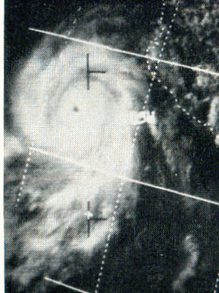
The 1966 Atlantic hurricane season saw the Weather Bureau office in Miami, Florida, be designated as the National Hurricane Center (NHC) and assume responsibility of tropical cyclone forecasting in the basin. The season officially began on June 1, and lasted until November 30. These dates conventionally delimit the period of each year when most tropical cyclones form in the Atlantic basin. It was an above-average season in terms of tropical storms, with a total of 15. The first system, Hurricane Alma, developed over eastern Nicaragua on June 4 and became the most recent major hurricane in the month of June. Alma brought severe flooding to Honduras and later to Cuba, but caused relatively minor impact in the Southeastern United States. Alma resulted in 90 deaths and about $210.1 million (1966 USD) in damage.

The 1970 Atlantic hurricane season officially began on June 1 and lasted until November 30. These dates conventionally delimit the period of each year when most tropical cyclones form in the Atlantic basin. The season was fairly average, with 14 named storms forming, of which seven were hurricanes. Two of those seven became major hurricanes, which are Category 3 or higher on the Saffir–Simpson scale. Also, this was the first season in which reconnaissance aircraft flew into all four quadrants of a tropical cyclone.

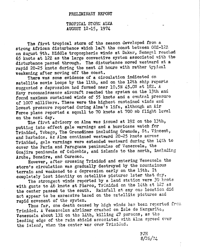
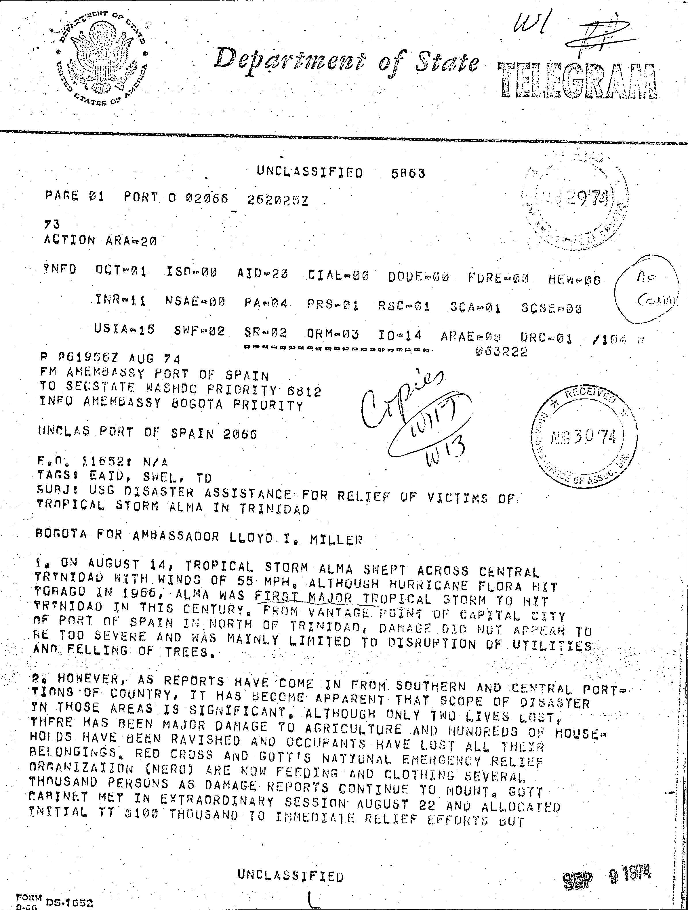
The 1974 Atlantic hurricane season was a destructive and deadly hurricane season. In terms of overall activity, it was near average, with eleven named storms forming, of which four became hurricanes. Two of those four became major hurricanes, which are Category 3 or higher systems on the Saffir–Simpson scale. The season officially began on June 1 and lasted until November 30. These dates conventionally delimit the period of each year when most tropical cyclones form in the Atlantic Ocean.

The 1990 Atlantic hurricane season was the most active Atlantic hurricane season since 1969, with a total of 14 named storms. The season also featured eight hurricanes, one of which intensified into a major hurricane. It officially began on June 1, 1990, and lasted until November 30, 1990. These dates conventionally delimit the period of each year when most tropical cyclones form in the Atlantic basin. However, tropical cyclogenesis can occur prior to the start of the season, as demonstrated with Tropical Depression One, which formed in the Caribbean Sea on May 24.

Hurricane Carmen was the most intense tropical cyclone of the 1974 Atlantic hurricane season. A destructive storm with widespread impacts, Carmen developed from a tropical wave that emerged from Africa toward the end of August. The disturbance traveled westward, and organized as a tropical depression east of the Lesser Antilles on August 29. The storm moved through the Caribbean Sea, and in an environment conducive to intensification, it quickly strengthened to its initial peak intensity as a Category 4 hurricane on the Saffir–Simpson Hurricane Scale. Carmen moved ashore on the Yucatán Peninsula, where, despite striking a sparsely populated region, it caused significant crop damage and killed several people. Before the storm's arrival, officials had set up several evacuation centers, and many residents had moved to higher ground.

The 1911 Atlantic hurricane season was a relatively inactive hurricane season, with only six known tropical cyclones forming in the Atlantic during the summer and fall. There were three suspected tropical depressions, including one that began the season in February and one that ended the season when it dissipated in December. Three storms intensified into hurricanes, two of which attained Category 2 status on the modern-day Saffir–Simpson Hurricane Scale. Storm data is largely based on the Atlantic hurricane database, which underwent a thorough revision for the period between 1911 and 1914 in 2005.

The 1975 Pacific hurricane season officially started May 15, 1975, in the eastern Pacific, and June 1, 1975, in the central Pacific, and lasted until November 30, 1975. These dates conventionally delimit the period of each year when most tropical cyclones form in the northeast Pacific Ocean.

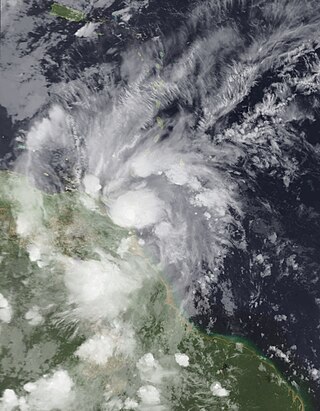
Tropical Storm Bret was the deadliest natural disaster in Venezuela since the 1967 Caracas earthquake. The third tropical cyclone of the 1993 Atlantic hurricane season, Bret formed on August 4 from a westward-moving, African tropical wave. Bret would later peak as a 60 mph (97 km/h) tropical storm as it neared Trinidad. It took an extremely southerly course through the Caribbean, passing over the coasts of Venezuela and Colombia. High terrain in the northern parts of those countries severely disrupted the circulation of the storm, and Bret had weakened to a tropical depression before emerging over the extreme southwestern Caribbean Sea. There, it restrengthened to a tropical storm and made landfall in Nicaragua on August 10, dissipating soon after. Bret's remnants reached the Pacific Ocean, where they would later regenerate into Hurricane Greg.

Hurricane Iris was the first of three tropical cyclones to affect the Lesser Antilles in a three-week period, preceding the more destructive hurricanes Luis and Marilyn. The ninth named storm and fifth hurricane of the 1995 Atlantic hurricane season, Iris developed from a tropical wave to the east of the Lesser Antilles on August 22 and attained hurricane status within 30 hours. The hurricane weakened to a tropical storm before crossing the islands of the eastern Caribbean from August 26 through August 28. During that time, Iris became one of four active tropical storms in the Atlantic basin. Earlier it had interacted with Hurricane Humberto, and beginning on August 30, Iris interacted with Tropical Storm Karen. Iris re-intensified into a hurricane and attained peak sustained winds of 110 mph (175 km/h) while moving slowly across the central Atlantic. The hurricane accelerated to the north and absorbed a dissipating Karen on September 3. Iris weakened to a tropical storm and became extratropical on September 4, though its remnants re-attained hurricane-force winds, before affecting western Europe on September 7. The storm dissipated soon afterward.

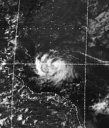
Hurricane Caroline was one of two tropical cyclones to affect northern Mexico during the 1975 Atlantic hurricane season. The third named storm and second hurricane of the season, Caroline developed on August 24 north of the Dominican Republic. The system crossed Cuba and briefly degenerated into a tropical wave due to land interaction. However, upon emergence into the western Caribbean Sea, it was once again designated as a tropical depression after a well-defined circulation was observed on satellite imagery. Moving towards the west-northwest, the cyclone clipped the northern portion of the Yucatán Peninsula before entering the Gulf of Mexico. Caroline was upgraded to a tropical storm on August 29 in the central Gulf of Mexico before rapid intensification began. Early on August 31, Caroline reached its peak intensity with winds of 115 mph (185 km/h), before landfall south of Brownsville, Texas with winds of 105 mph (169 km/h) shortly thereafter. After moving inland, Caroline quickly weakened and dissipated over the mountainous terrain of northeastern Mexico on September 1. There were only two deaths from Caroline, both indirect. However, there was heavy rainfall in southern Texas and Mexico, including almost 12 in (300 mm) at Port Isabel.

Hurricane Anna impacted Central America and the Windward Islands in July 1961. The first tropical cyclone and first hurricane of the 1961 Atlantic hurricane season, Anna developed on July 20 from an easterly wave located in the Intertropical Convergence Zone (ITCZ) over the Windward Islands. Initially a tropical storm, it moved westward across the Caribbean Sea. Favorable environmental conditions allowed Anna to reach hurricane intensity late on July 20. Early on the following day, the storm strengthened into a Category 2 hurricane on the modern-day Saffir–Simpson hurricane wind scale. Intensification continued, and on July 22, Anna peaked with maximum sustained winds of 105 mph (169 km/h). The hurricane then weakened slightly while approaching the coast of Honduras. Further weakening occurred; when Anna made landfall in Belize on July 24, winds decreased to 80 mph (130 km/h). Anna rapidly weakened over land and dissipated later that day.

Hurricane Felix was an extremely powerful Category 5 Atlantic hurricane which was the southernmost-landfalling Category 5 storm on record, surpassing Hurricane Edith of 1971. It was the sixth named storm, second hurricane, and second Category 5 hurricane of the 2007 Atlantic hurricane season. Felix formed from a tropical wave on August 31, passing through the southern Windward Islands on September 1 before strengthening to attain hurricane status. On the next day, Felix rapidly strengthened into a major hurricane, and early on September 3 it was upgraded to Category 5 status; at 2100 UTC on the same day, the hurricane was downgraded to Category 4 status, but strengthened into a Category 5 hurricane for the second and final time by the morning of September 4.

Hurricane Bridget of June 1971 was one of the worst hurricanes to strike the Mexican city of Acapulco. It formed on June 14 as a tropical depression, which is a minimal tropical cyclone with winds less than gale force. However, it was soon upgraded to a tropical storm, and Bridget steadily intensified to become a hurricane on June 15. After peaking at Category 2 intensity, it weakened to a tropical storm on June 17, then made landfall in Mexico. Hours later, however, it turned offshore as a tropical depression. Bridget dissipated on June 20 after leaving heavy damage and 17 deaths in the Acapulco area.
Hurricane Irene–Olivia was the first actively tracked tropical cyclone to move into the eastern Pacific Ocean from the Atlantic basin. It originated as a tropical depression on September 11, 1971, in the tropical Atlantic. The cyclone tracked nearly due westward at a low latitude, passing through the southern Windward Islands and later over northern South America. In the southwest Caribbean Sea, it intensified to a tropical storm and later a hurricane. Irene made landfall on southeastern Nicaragua on September 19, and maintained its circulation as it crossed the low-lying terrain of the country. Restrengthening after reaching the Pacific, Irene was renamed Hurricane Olivia, which ultimately attained peak winds of 115 mph (185 km/h). Olivia weakened significantly before moving ashore on the Baja California Peninsula on September 30; the next day it dissipated.

The 1933 Trinidad hurricane was the third-farthest-east tropical storm to form in the Main Development Region (MDR) so early in the calendar year on record and was one of three North Atlantic tropical cyclones on record to produce hurricane-force winds in Venezuela. The second tropical storm and first hurricane of the extremely active 1933 Atlantic hurricane season, the system formed on June 24 to the east of the Lesser Antilles. It moved westward and attained hurricane status before striking Trinidad on June 27. The storm caused heavy damage on the island, estimated at $3 million. The strong winds downed trees and destroyed hundreds of houses, leaving about 1,000 people homeless. Later, the hurricane crossed the northeastern portion of Venezuela, where power outages and damaged houses were reported.
Tropical Storm Bret was the earliest named storm in the calendar year to develop in the Main Development Region of the Atlantic basin on record. The second tropical cyclone of the 2017 Atlantic hurricane season, Bret formed from a tropical wave that had exited off the coast of West Africa on June 12. The disturbance moved swiftly across the Atlantic for several days, steadily organizing despite its low latitude. On June 18, the organization increased enough for the National Hurricane Center (NHC) to begin issuing warnings disturbance while it was located southeast of the Windward Islands. The system continued to organize, and by the next day, it had developed into a tropical storm, the second of the 2017 Atlantic hurricane season. Bret continued moving swiftly to the west and struck Trinidad and Tobago early on June 20, before entering the Caribbean Sea, dissipating shortly afterwards.


