Tropical Storm Kammuri (2008)

Last updated

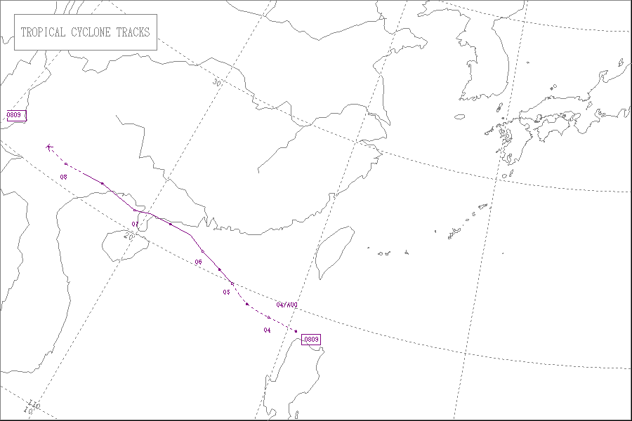
Severe Tropical Storm Kammuri, known in the Philippines as Tropical Storm Julian, was a weak but deadly tropical storm which impacted the Philippines, China, Vietnam, and Hong Kong in August 2008. The ninth named storm of the 2008 Pacific typhoon season, Kammuri developed as a tropical depression on August 4 north of Luzon. The next day, the depression intensified into a tropical storm, resulting in the Japan Meteorological Agency naming it Kammuri. The following day, Kammuri reached its peak intensity with sustained winds of 50 kn (93 km/h) before making landfall in Guangdong province, China. This would make Kammuri weaken into a tropical storm that evening, resulting in the JTWC issuing their last advisory on the system. Kammuri would later emerge in the Gulf of Tonkin the next day, making a second landfall over Guangxi province, China. After Kammuri made landfall, the JMA issued its final advisory on Kammuri.

Contents

Heavy rains from Kammuri in Vietnam led to the loss of at least 100 lives and destroyed over 300 homes while damaging over 3,500 others. [1] [2]

Meteorological history

Map plotting the storm's track and intensity, according to the Saffir-Simpson scale

.mw-parser-output .hidden-begin{box-sizing:border-box;width:100%;padding:5px;border:none;font-size:95%}.mw-parser-output .hidden-title{font-weight:bold;line-height:1.6;text-align:left}.mw-parser-output .hidden-content{text-align:left}@media all and (max-width:500px){.mw-parser-output .hidden-begin{width:auto!important;clear:none!important;float:none!important}}
Map key
Saffir-Simpson scale
.mw-parser-output .div-col{margin-top:0.3em;column-width:30em}.mw-parser-output .div-col-small{font-size:90%}.mw-parser-output .div-col-rules{column-rule:1px solid #aaa}.mw-parser-output .div-col dl,.mw-parser-output .div-col ol,.mw-parser-output .div-col ul{margin-top:0}.mw-parser-output .div-col li,.mw-parser-output .div-col dd{page-break-inside:avoid;break-inside:avoid-column}
.mw-parser-output .legend{page-break-inside:avoid;break-inside:avoid-column}.mw-parser-output .legend-color{display:inline-block;min-width:1.25em;height:1.25em;line-height:1.25;margin:1px 0;text-align:center;border:1px solid black;background-color:transparent;color:black}.mw-parser-output .legend-text{}
Tropical depression (<=38 mph, <=62 km/h)

Tropical storm (39-73 mph, 63-118 km/h)

Category 1 (74-95 mph, 119-153 km/h)

Category 2 (96-110 mph, 154-177 km/h)

Category 3 (111-129 mph, 178-208 km/h)

Category 4 (130-156 mph, 209-251 km/h)

Category 5 (>=157 mph, >=252 km/h)

Unknown
Storm type
Tropical cyclone
Subtropical cyclone
Extratropical cyclone, remnant low, tropical disturbance, or monsoon depression Kammuri 2008 track.png
Map plotting the storm's track and intensity, according to the Saffir–Simpson scale
Map key
  Tropical depression (≤38 mph, ≤62 km/h)
  Tropical storm (39–73 mph, 63–118 km/h)
  Category 1 (74–95 mph, 119–153 km/h)
  Category 2 (96–110 mph, 154–177 km/h)
  Category 3 (111–129 mph, 178–208 km/h)
  Category 4 (130–156 mph, 209–251 km/h)
  Category 5 (≥157 mph, ≥252 km/h)
  Unknown
Storm type
ArrowUp.svg Extratropical cyclone, remnant low, tropical disturbance, or monsoon depression

On August 3, PAGASA identified a tropical disturbance which was located in the South China Sea to the north of Luzon island in the Philippines and was later classified as Tropical Depression Julian. [3] Later that day the Japan Meteorological Agency (JMA) designated Julian as a minor tropical depression and initiated advisories on the tropical depression. [4]

Early the next day the JMA started to issue full advisories on the tropical depression. [5] The Joint Typhoon Warning Center (JTWC) then started to issue warnings on the tropical depression later that day with them designating it as Tropical Depression 10W. [6] Furthermore, later that day both PAGASA and the JTWC upgraded the tropical depression to a tropical storm. [7] [8]

Infra-red satellite image of Tropical Storm Kammuri intensifying on August 5 Kammuri 05 August 2008.gif
Infra-red satellite image of Tropical Storm Kammuri intensifying on August 5

On August 5, the JMA upgraded the depression to a tropical storm and named it Kammuri, [9] whilst PAGASA released their final advisory on Tropical Storm Kammuri (Julian) later that day as it moved out of their Area of Responsibility and headed towards mainland China. [10] The Hong Kong Observatory (HKO) then upgraded Kammuri to a severe tropical storm late on August 5, with the JMA doing the same early the next morning. [11] [12]

However, Kammuri started to weaken after making landfall along the south coast of China in the Western Guangdong Province at about 12pm UTC on August 6. [13] [14] After Kammuri had made landfall the JMA downgraded Kammuri to a tropical storm, [15] whilst the JTWC issued their final advisory later that day on Tropical Storm Kammuri. [16] Early the next day Tropical Storm Kammuri emerged into the Gulf of Tonkin, however later that day Kammuri made landfall again in the Guangxi province of China. After making landfall for the second time on August 7 Kammuri weakened to a tropical depression as the JMA issued its final advisory. [17] However the JMA continued to monitor the depression in their WWJP25 warnings until early on August 8. [18]

Preparations

Philippines

As Tropical Depression Julian formed to the north of the Philippines On August 3, PAGASA issued Storm Signal #1, a warning for winds of 30–60 km/h (19–37 mph), for parts of Luzon. The parts of Luzon that were under Public Storm Signal #1 included the Batanes Group of Islands, Babuyan Group of Islands, Calayan Group of Islands, northern Cagayan, Apayao, Ilocos Norte, Ilocos Sur, Abra and La Union. [3] Early on the afternoon of August 4 PAGASA lowered Storm Signal #1 for all regions of Luzon except for Ilocos Norte, Ilocos Sur, Abra, La Union. [19] Early the next morning they lowered the rest of the Public Warning Signals as they released their final advisory on Julian. [10]

China

Macau

Late on August 5, the weather bureau of Macau hoisted the Gale or Storm Signal No.8, whilst earlier in the day they had hoisted Strong Wind Signal No.3. The weather bureau of Macau then replaced signal No.8 with signal No.3 as the storm moved away from Macau. [20]

Hong Kong

Early on August 4, the Hong Kong Observatory (HKO) started to issue public warnings on a tropical depression which was located within 500 nmi (930 km) of Hong Kong. Within their first advisory on Kammuri the HKO raised the Standby Signal No.1 for Hong Kong [21] Late the next day the HKO hoisted the Strong Wind Signal No.3 which meant that winds above 25 mph (40 km/h) were expected to be blowing in Hong Kong within 12 hours. [21] However, during the morning of August 6 the HKO issued the Northeast Gale or Storm Signal No.8. [21] Later that day, the HKO hoisted the Southeast Gale or Storm Signal No.8, which was replacing the 8NE Warning [21] However nine hours later the HKO removed the 8SE warning and downgraded it to Signal No.3 later that day, which was in force for 11 hours before it was downgraded to Signal 1 [21] which was in force for 3 hours before all signals were cancelled. [21]

Impact

Severe Tropical Storm Kammuri (Julian)
Kammuri 2008-08-05 0255Z.jpg
Severe Tropical Storm Kammuri at peak intensity on August 6

Philippines

Tropical Storm Julian (Kammuri) did not make landfall in the Philippines. However, it enhanced the southwest monsoon which continued to bring heavy rain to the Philippines. [10] However, no damage was reported in the Philippines [22]

China

Kammuri affected athletes training for the Olympics which were about to be held within China and Hong Kong.[ citation needed ]

Macau

Kammuri caused ferry services between Macau and Guangdong Province to close down. Bus services were cancelled with most plane flights cancelled or severely delayed [23]

Hong Kong

The impact of Tropical Storm Kammuri was felt strongly in Hong Kong, shortly before its landfall in China, with at least 37 people being injured. [24] The public transport service were halted or reduced and as significant cross winds affected the Hong Kong International Airport the Airport Authority had to cancel or delay over 380 flights with five others diverted to other airports. [24] There were also over 40 reports of fallen trees and collapsed scaffoldings in various districts of Hong Kong. There was a report of a landslide in Tai Hang. At least 10 people had to be evacuated in Kwun Tong as the zinc roof of their hut was blown away. [24]

Vietnam

In Vietnam, at least 127 fatalities would occur while 34 others were missing since Kammuri caused flash flooding and landslides. [25] Entire towns and villages were cut off. [2] [26] Hundreds of tourists were also landlocked in Sa Pa and in Lào Cai.[ citation needed ]

See also

Related Research Articles

<span class="mw-page-title-main">2006 Pacific typhoon season</span> Typhoon season in the Western Pacific Ocean

The 2006 Pacific typhoon season was a near-average season which produced a total of 23 named storms, 15 typhoons, and six super typhoons. The season ran throughout 2006, though most tropical cyclones typically develop between May and October. The season's first named storm, Chanchu, developed on May 9, while the season's last named storm, Trami, dissipated on December 20.

<span class="mw-page-title-main">2007 Pacific typhoon season</span> Typhoon season in the Western Pacific Ocean

The 2007 Pacific typhoon season was a near average season which featured 24 named storms, fourteen typhoons, and five super typhoons. It was an event in the annual cycle of tropical cyclone formation, in which tropical cyclones form in the western Pacific Ocean. The season ran throughout 2007, though most tropical cyclones typically develop between May and November. The season's first named storm, Kong-rey, developed on March 30, while the season's last named storm, Mitag, dissipated on November 27. The season's first typhoon, Yutu, reached typhoon status on May 18, and became the first super typhoon of the year on the next day.

<span class="mw-page-title-main">Tropical Storm Kammuri (2002)</span> Pacific severe tropical storm in 2002

Severe Tropical Storm Kammuri, known in the Philippines as Tropical Storm Lagalag, killed hundreds of people in the wake of a deadly flood season in China. The system developed from a large monsoonal system that persisted toward the end of July 2002 near the Philippines. On August 2, a tropical depression formed off the northwest coast of Luzon and moved west-northwestward. Late on August 3, it intensified into Tropical Storm Kammuri off the coast of Hong Kong. A weakening ridge turned the storm northward toward the coast of China. The storm made landfall with late on August 4, after reaching peak winds of 100 km/h (65 mph). The system dissipated over the mountainous coastline of eastern China and merged with a cold front on August 7.

<span class="mw-page-title-main">2008 Pacific typhoon season</span> Typhoon season in the Western Pacific Ocean

The 2008 Pacific typhoon season was a below average season which featured 22 named storms, eleven typhoons, and two super typhoons. The season had no official bounds; it ran year-round in 2008, but most tropical cyclones tend to form in the northwestern Pacific Ocean between May and November. These dates conventionally delimit the period of each year when most tropical cyclones form in the northwestern Pacific Ocean.

<span class="mw-page-title-main">Timeline of the 2008 Pacific typhoon season</span>

This timeline documents all the storm formations, strengthening, weakening, landfalls, extratropical transitions, as well as dissipation during the 2008 Pacific typhoon season. The 2008 Pacific typhoon season officially started on January 1, 2008 and ended on January 1, 2009. The first tropical cyclone of the season formed on January 13. The timeline also includes information which was not operationally released, meaning that information from post-storm reviews by the various warning agencies, such as information on a storm that was not operationally warned on, has been included.

<span class="mw-page-title-main">Tropical Storm Halong (2008)</span> Pacific severe tropical storm in 2008

Severe Tropical Storm Halong, known in the Philippines as Typhoon Cosme, was the fourth severe tropical storm named by the Japan Meteorological Agency (JMA), which is the Regional Specialized Meteorological Centre for the Northwestern Pacific Ocean. The Joint Typhoon Warning Center also recognized Halong as the fifth tropical depression, the fourth tropical storm, as well as the third typhoon of the 2008 Pacific typhoon season.

<span class="mw-page-title-main">Typhoon Nuri (2008)</span> Pacific typhoon in 2008

Typhoon Nuri, known in the Philippines as Typhoon Karen, was the 12th named storm and the seventh typhoon that was recognised by the Japan Meteorological Agency. The Joint Typhoon Warning Center recognised it as the 13th tropical depression, the 12th tropical storm and the 8th typhoon of the 2008 Pacific typhoon season. The name Nuri was submitted to the World Meteorological Organisation's Typhoon Committee by Malaysia in 2003 after the name Rusa was retired in 2002. The name Nuri is Malay for a blue crowned parroquet, a type of parrot. The name Karen was assigned by PAGASA to a tropical depression for the second time, the other time being in 2004 to Typhoon Rananim.

<span class="mw-page-title-main">Typhoon Sinlaku (2008)</span> Pacific typhoon in 2008

Typhoon Sinlaku, known in the Philippines as Typhoon Marce, was a typhoon which affected the Philippines, Taiwan, China and Japan. It was recognised as the 13th named storm and the ninth typhoon of the 2008 Pacific typhoon season by the Japan Meteorological Agency.

<span class="mw-page-title-main">Typhoon Hagupit (2008)</span> Pacific typhoon in 2008

Typhoon Hagupit, known in the Philippines as Typhoon Nina, was a powerful cyclone that caused widespread destruction along its path in September 2008. The 21st depression, 14 tropical storm and 10th typhoon of the 2008 Pacific typhoon season, Hagupit developed from a tropical wave located a couple hundred miles east of the Marshall Islands on September 14. Moving generally north-west westwards towards the Philippines, the depression gradually intensified into a tropical storm the following day, and then into became a typhoon on September 22 off the northern coast of Luzon. Located within an environment conducive for strengthening, Hagupit rapidly strengthened to attain 10-min sustained winds of 165 kilometres per hour and 1-min sustained winds of 230 kilometres per hour. After making landfall in Guangdong province in China at peak intensity on September 23, Hagupit rapidly weakened over rugged terrain and dissipated on the 25th.

<span class="mw-page-title-main">Tropical Storm Maysak (2008)</span> Pacific severe tropical storm in 2008

Severe Tropical Storm Maysak, known in the Philippines as Tropical Storm Quinta-Siony, was recognised as the 19th tropical storm by the Japan Meteorological Agency. It was also recognised as the 24th tropical depression and the 22nd tropical storm by the Joint Typhoon Warning Center of the 2008 Pacific typhoon season.

<span class="mw-page-title-main">2009 Pacific typhoon season</span> Typhoon season in the Western Pacific Ocean

The 2009 Pacific typhoon season was a below average season that spawned only 22 named storms, 13 typhoons, and five super typhoons. It was also recognized as the deadliest season in the Philippines for decades. The first half of the season was very quiet whereas the second half of the season was extremely active. The season's first named storm, Kujira, developed on May 3 while the season's last named storm, Nida, dissipated on December 3.

<span class="mw-page-title-main">Typhoon Prapiroon (2006)</span> Pacific typhoon in 2006

Typhoon Prapiroon, known in the Philippines as Tropical Storm Henry, was a minimal typhoon which caused deadly flooding in southern China in August 2006. Prapiroon developed out of a persistent area of convection accompanied by an area of low pressure on July 25 about 120 km (75 mi) west-southwest of Yap. Two days later, both the Japan Meteorological Agency (JMA) and PAGASA classified the system as a tropical depression, with PAGASA giving it the local name 'Henry'. By July 31, the Joint Typhoon Warning Center (JTWC) classified the system as Tropical Depression 07W. A strong subtropical ridge located to the north of the depression led to a west-northwest movement for most of the storm existence.

<span class="mw-page-title-main">2010 Pacific typhoon season</span> Typhoon season in the Western Pacific Ocean

The 2010 Pacific typhoon season, with 14 named storms, was the least active Pacific typhoon season on record. Seven of them strengthened into typhoons while one reached super typhoon intensity. All of the 14 named storms developed west of 150°E.

<span class="mw-page-title-main">Timeline of the 2009 Pacific typhoon season</span>

This timeline documents all of the events of the 2009 Pacific typhoon season which was the period that tropical cyclones formed in the Western Pacific Ocean during 2009, with most of the tropical cyclones forming between May and November. The scope of this article is limited to the Pacific Ocean, north of the equator between 100°E and the International Date Line. Tropical storms that form in the entire Western Pacific basin are assigned a name by the Japan Meteorological Agency. Tropical depressions that form in this basin are given a number with a "W" suffix by the United States' Joint Typhoon Warning Center. In addition, the Philippine Atmospheric, Geophysical and Astronomical Services Administration (PAGASA) assigns names to tropical cyclones that enter or form in the Philippine area of responsibility. These names, however, are not in common use outside of the Philippines.

<span class="mw-page-title-main">Tropical Storm Mujigae</span> Pacific tropical storm in 2009

Tropical Storm Mujigae, known in the Philippines as Tropical Depression Maring was a tropical storm that affected the Philippines, China, Hong Kong, and Vietnam in September 2009. Mujigae originated from an area of convection that developed along with a monsoon trough with favorable conditions on 8 September. The disturbance organized to a tropical depression and was assigned the names 14W by the Joint Typhoon Warning Center and Maring by PAGASA later that day. Tropical Depression 14W would rapidly develop and attain tropical storm status by the JMA and be assigned the name Mujigae on 10 September. Mujigae soon encountered unfavorable conditions with wind shear and make landfall in Hainan Island on 11 September and Vietnam on 12 September before rapidly weakening and dissipating.

<span class="mw-page-title-main">2017 Pacific typhoon season</span> Typhoon season in the Western Pacific Ocean

The 2017 Pacific typhoon season was a below-average season in terms of accumulated cyclone energy and the number of typhoons and super typhoons, and the first since the 1977 season to not produce a Category 5-equivalent typhoon on the Saffir–Simpson scale. The season produced a total of 27 named storms, 11 typhoons, and only two super typhoons, making it an average season in terms of storm numbers. It was an event in the annual cycle of tropical cyclone formation, in which tropical cyclones form in the western Pacific Ocean. The season runs throughout 2017, though most tropical cyclones typically develop between May and October. The season's first named storm, Muifa, developed on April 25, while the season's last named storm, Tembin, dissipated on December 26. This season also featured the latest occurrence of the first typhoon of the year since 1998, with Noru reaching this intensity on July 23.

<span class="mw-page-title-main">Typhoon Chanthu (2010)</span> Pacific typhoon in 2010

Typhoon Chanthu, known in the Philippines as Tropical Storm Caloy, was a weak typhoon that impacted southeastern China in the 2010 Pacific typhoon season.

<span class="mw-page-title-main">Timeline of the 2010 Pacific typhoon season</span>

This timeline documents all of the events of the 2010 Pacific typhoon season. Most of the tropical cyclones forming between May and November. The scope of this article is limited to the Pacific Ocean, north of the equator between 100°E and the International Date Line. Tropical storms that form in the entire Western Pacific basin are assigned a name by the Japan Meteorological Agency. Tropical depressions that form in this basin are given a number with a "W" suffix by the United States' Joint Typhoon Warning Center. In addition, the Philippine Atmospheric, Geophysical and Astronomical Services Administration (PAGASA) assigns names to tropical cyclones that enter or form in the Philippine area of responsibility. These names, however, are not in common use outside of the Philippines.

<span class="mw-page-title-main">Tropical Storm Linfa (2015)</span> Pacific typhoon in 2015

Severe Tropical Storm Linfa, known in the Philippines as Severe Tropical Storm Egay, was a tropical cyclone that affected the northern Philippines, Taiwan and southern China in early July 2015. The tenth named storm of the annual typhoon season, Linfa developed on July 1 over in the Philippine Sea. It moved erratically westward toward the Philippines, eventually striking the island of Luzon on July 4. Linfa weakened across the island, but reorganized over the South China Sea. It turned northward and strengthened to near typhoon intensity, or winds of 120 km/h (75 mph), but weakened as it curved to the northwest toward southern China. On July 9, the storm made landfall along the Chinese province of Guangdong, dissipating the next day west of Hong Kong.

<span class="mw-page-title-main">Tropical Storm Higos (2020)</span> Pacific severe tropical storm in 2020

Severe Tropical Storm Higos, known in the Philippines as Tropical Depression Helen, was a tropical storm that affected China and Vietnam around the same area as Nuri two months prior. Higos formed from a tropical disturbance north of Luzon, the Philippines, on August 16. The storm tracked northeast and quickly intensified, becoming a tropical storm on August 17. The storm made landfall in Zhuhai, Guangdong at peak intensity on August 19, and quickly weakened soon after. Higos killed 7 people and caused 45 billion đồng in damages in Vietnam. Higos also caused more than US$140 million in damages, but no fatalities in China.

References

  1. "Tropical storm kills 92 in Vietnam". Radio Netherlands Worldwide. Archived from the original on September 27, 2008. Retrieved 2008-08-10.
  2. 1 2 "137 dead, missing after storms hit northern Vietnam". AFP. Archived from the original on 2012-07-07. Retrieved 2008-08-10.
  3. 1 2 "PAGASA Advisory 1". PAGASA. Archived from the original on August 4, 2008. Retrieved 2008-08-06.{{cite web}}: CS1 maint: unfit URL (link)
  4. "MA WWJP25 Advisory 06-08-08 18z". JMA. Retrieved 2008-08-06.[ permanent dead link ]
  5. "JMA Advisory 04-08-08 00z". JMA. Archived from the original on 2008-08-28. Retrieved 2008-08-06.
  6. "JTWC Advisory 1". JTWC. Retrieved 2008-08-06.[ permanent dead link ]
  7. "PAGASA Advisory 3". PAGASA. Archived from the original on May 7, 2008. Retrieved 2008-08-06.{{cite web}}: CS1 maint: unfit URL (link)
  8. "JTWC Advisory 3". JTWC. Retrieved 2008-08-06.[ permanent dead link ]
  9. "JMA Advisory 05-08-08 00z". JMA. Archived from the original on 2008-08-28. Retrieved 2008-08-06.
  10. 1 2 3 "PAGASA Advisory 07". PAGASA. Archived from the original on May 7, 2008. Retrieved 2008-08-06.{{cite web}}: CS1 maint: unfit URL (link)
  11. "HKO Advisory 05-08-08 20z". HKO. Retrieved 2008-08-06.[ permanent dead link ]
  12. "JMA Advisory 06-08-08 00z". JMA. Archived from the original on 2008-08-28. Retrieved 2008-08-06.
  13. "Kammurri Landfall". CMA. Archived from the original on 2011-07-16. Retrieved 2008-08-07.
  14. "JTWC Prognostic Advisory 11". JTWC. Retrieved 2008-08-06.[ permanent dead link ]
  15. "JMA Advisory 06-08-08 12z". JMA. Archived from the original on 2008-08-28. Retrieved 2008-08-06.
  16. "JTWC Advisory 12". JTWC. Retrieved 2008-08-06.[ permanent dead link ]
  17. "JMA Advisory 07-08-08 21z". JMA. Archived from the original on 2008-08-28. Retrieved 2008-08-07.
  18. "JMA WWJP25 Advisory 08-08-08 00z". JMA. Retrieved 2008-08-08.[ permanent dead link ]
  19. "PAGASA Advisory 4". PAGASA. Archived from the original on May 7, 2008. Retrieved 2008-08-06.{{cite web}}: CS1 maint: unfit URL (link)
  20. "Archived copy". Archived from the original on 2011-10-02. Retrieved 2008-08-10.{{cite web}}: CS1 maint: archived copy as title (link)
  21. 1 2 3 4 5 6 "HKO cyclone warning signals database Kammuri". HKO. Retrieved 2008-08-27.
  22. "Situation Report on the Effects of Tropical Storm Julian" (PDF). Philippine National Disaster Coordinating Council. Archived from the original (PDF) on 2008-09-11. Retrieved 2008-08-06.
  23. "Traffic halted as tropical storm Kammuri approaches Macao".
  24. 1 2 3 "HKO TCR". HKO. Retrieved 2008-08-29.
  25. "Storm death toll at 127 | NEWS.com.au". Archived from the original on September 17, 2008.
  26. "Dozens killed in Vietnam floods". BBC. 2008-08-09. Retrieved 2008-08-09.