The 2001 Pacific hurricane season was a relatively near-average Pacific hurricane season which produced sixteen named storms, though most were rather weak and short-lived including one unnamed tropical storm which was operationally recognized as a tropical depression, the first such occurrence since 1996. Only eight hurricanes formed and two major hurricanes. The season officially began on May 15 in the East Pacific Ocean, and on June 1 in the Central Pacific; they ended on November 30. These dates conventionally delimit the period of each year when most tropical cyclones form in the Pacific basin. However, the formation of tropical cyclones is possible at any time of the year.

The 2000 Pacific hurricane season was an above-average Pacific hurricane season, although most of the storms were weak and short-lived. There were few notable storms this year. Tropical storms Miriam, Norman, and Rosa all made landfall in Mexico with minimal impact. Hurricane Daniel briefly threatened the U.S. state of Hawaii while weakening. Hurricane Carlotta was the strongest storm of the year and the second-strongest June hurricane in recorded history. Carlotta killed 18 people when it sank a freighter. Overall, the season was significantly more active than the previous season, with 19 tropical storms. In addition, six hurricanes developed. Furthermore, there were total of two major hurricanes.

The 1998 Pacific hurricane season was a fairly average Pacific hurricane season. Despite this, it had nine hurricanes and six major hurricanes, which was well above average. The season officially started on May 15 in the eastern Pacific and on June 1 in the central Pacific, and ended on November 30; these dates conventionally delimit the period during which most tropical cyclones form in that region. The first tropical cyclone developed on June 11, about ten days later than the normal start of the season. The final storm of the year, Hurricane Madeline, dissipated on October 20. Storm activity in the Central Pacific Hurricane Center's warning zone was low, with just one tropical depression observed in the region. Two tropical cyclones from the eastern Pacific also entered the central Pacific; the former did so as a hurricane.

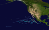
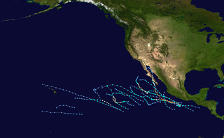
The 1992 Pacific hurricane season is the most active Pacific hurricane season on record, featuring 27 named storms. The season also produced the second-highest ACE value on record in the basin, only surpassed by the 2018 season. The 1992 season officially started on May 15 in the eastern Pacific, and on June 1 in the central Pacific, and lasted until November 30. These dates conventionally delimit the period of each year when most tropical cyclones form in the northeastern Pacific Ocean. However, tropical cyclogenesis is possible at any time of the year, as demonstrated by the development of Hurricane Ekeka on January 28, and Tropical Storm Hali two months later.

The 1991 Pacific hurricane season was a near-average Pacific hurricane season. The worst storm this year was Tropical Storm Ignacio, which killed 23 people in Mexico and injured 40 others. Elsewhere, Hurricane Fefa caused flooding in Hawaii. Hurricane Kevin was the strongest system of the season and became the then longest-lasting hurricane in the eastern north Pacific basin at the time, and Hurricane Nora was the strongest November storm to that point. The season officially started on May 15, 1991, in the eastern Pacific, and on June 1, 1991, in the central Pacific. It lasted until November 30, 1991, in both basins. These dates conventionally delimit the period of each year when most tropical cyclones form in the northeastern Pacific Ocean.

The 1990 Pacific hurricane season was a very active season which observed 21 named storms within the basin. The season also produced the fourth highest ACE index value on record. The season was officially started on May 15 in the eastern Pacific, and on June 1 in the central Pacific, and lasted until November 30. These dates conventionally delimit the period of each year when most tropical cyclones form in the northeastern Pacific Ocean. However, the formation of tropical cyclones is possible at any time of the year, as illustrated in 1990 by the formation of the season's first named storm, Hurricane Alma, on May 12. At the time, this was the earliest formation of a tropical storm on record in the eastern Pacific

The 1976 Pacific hurricane season was a very deadly and costly season. Hurricanes Kathleen, Liza, and Madeline were the most notable storms this year. Hurricane Kathleen caused death and destruction in California and Arizona due to flooding. Hurricane Liza was the deadliest storm of the season when it killed over 600 people in Mexico. Hurricane Madeline is notable for being one of the most intense Pacific hurricanes at landfall.
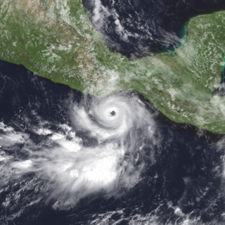
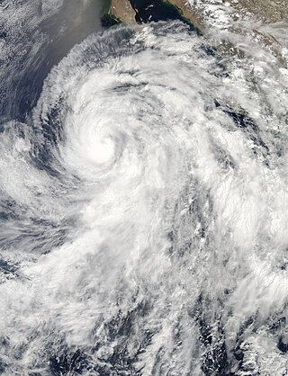
Hurricane Lester was a small but powerful tropical cyclone that caused heavy flooding in Central America and southern Mexico in October 1998. Lester was the fifteenth tropical cyclone, twelfth named storm and eighth hurricane of the 1998 Pacific hurricane season. Lester originated from a tropical wave that emerged off the coast of Africa on September 29. Under favorable conditions, the storm was classified as a tropical depression on October 15. The depression was upgraded to a tropical storm later that day and a hurricane on October 16. After undergoing fluctuations in intensity, Lester reached peak winds of 115 mph (185 km/h), a Category 3 hurricane on the Saffir-Simpson Hurricane Scale. After several days, it degenerated into a tropical storm on October 26, and dissipated shortly after. The hurricane made its closest approach to land on October 28, producing moderate winds and heavy rainfall. A mudslide triggered by the precipitation killed two children, although damage is unknown.

Tropical Storm Norman was a weak tropical cyclone that brought heavy rainfall to southwestern Mexico in October 2006. The fifteenth named storm of the 2006 Pacific hurricane season, Norman developed on October 9 from a tropical wave well to the southwest of Mexico. Unfavorable conditions quickly encountered the system, and within two days of forming, Norman dissipated as its remnants turned to the east. Thunderstorms gradually increased again, as it interacted with a disturbance to its east, and on October 15 the cyclone regenerated just off the coast of Mexico. The center became disorganized and quickly dissipated, bringing a large area of moisture which dropped up to 6 inches (150 mm) of rainfall to southwestern Mexico. Rainfall from the storm flooded about 150 houses, of which 20 were destroyed. One person was injured, and initially there were reports of two people missing due to the storm; however, it was not later confirmed.

The 2006 Pacific hurricane season was the first above-average season since 1997 which produced twenty-five tropical cyclones, with nineteen named storms, though most were rather weak and short-lived. Only eleven hurricanes formed and six major hurricanes. Following the inactivity of the previous seasons, forecasters predicted that season would be only slightly above active. It was also the first time since 2003 in which one cyclone of at least tropical storm intensity made landfall. The season officially began on May 15 in the East Pacific Ocean, and on June 1 in the Central Pacific; they ended on November 30. These dates conventionally delimit the period of each year when most tropical cyclones form in the Pacific basin. However, the formation of tropical cyclones is possible at any time of the year.

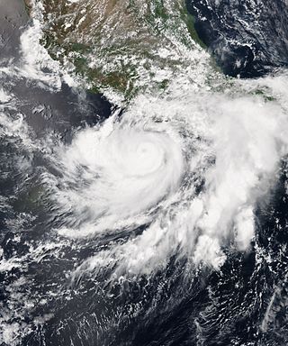
Hurricane Hernan was fourth and final tropical cyclone to strike Mexico at hurricane intensity during the 1996 Pacific hurricane season. The thirteenth tropical cyclone, eighth named storm, and fifth hurricane of the season, Hernan developed as a tropical depression from a tropical wave to the south of Mexico on September 30. The depression quickly strengthened, and became Tropical Storm Hernan later that day. Hernan curved north-northwestward the following day, before eventually turning north-northeastward. Still offshore of the Mexican coast on October 2, Hernan intensified into a hurricane. Six hours later, Hernan attained its peak as an 85 mph (140 km/h) Category 1 hurricane on the Saffir-Simpson Hurricane Wind Scale (SSHWS). After weakening somewhat, on 1000 UTC October 3, Hurricane Hernan made landfall near Barra de Navidad, Jalisco, with winds of 75 mph (120 km/h). Only two hours after landfall, Hernan weakened to a tropical storm. By October 4, Tropical Storm Hernan had weakened into a tropical depression, and dissipated over Nayarit on the following day.
Tropical Storm Odile was a late season tropical storm that formed during the 2008 Pacific hurricane season and affected parts of southern Mexico. A tropical depression formed on October 8, and became Tropical Storm Odile 18 hours later. The storm paralleled the south coast of Mexico, with the center located only several miles offshore. After peaking in intensity, increasing southeasterly vertical wind shear induced a trend of rapid weakening on the storm. Correspondingly, Odile was downgraded to a tropical depression early on 12 October, subsequently degenerating into a remnant low about 55 mi (85 km) south of Manzanillo, Colima. From thereon, the low proceeded slowly south-southwestward before dissipating on October 13. Since Odile stayed at sea, its effects along coastlines were limited. The most notable damages were caused by flooding along the southern coast of Mexico, mostly in Chiapas, Oaxaca, Guerrero and Michoacán. The exact amount of damage, however, remains unknown, and no fatalities were reported as a result of the storm.

Tropical Depression Two-E was a short-lived tropical cyclone that brought heavy rainfall to southwestern Mexico. It was the only cyclone during the month in the eastern North Pacific Ocean, forming on June 3 from a tropical wave. The depression initially moved northeastward, threatening the Mexican states of Michoacán and Guerrero with a potential of it attaining tropical storm status. It remained a tropical depression, weakening due to land interaction and wind shear, and on June 5 it dissipated just off the coast. Rainfall from the depression peaked at 19.1 inches (486 mm) in Acapulco, which resulted in mudslides and flooding. A total of 42 houses were flooded, and 72 people were forced to leave their homes due to the storm; no deaths were reported.

Tropical Storm Carlos was the first of five tropical cyclones to make landfall during the 2003 Pacific hurricane season. It formed on June 26 from a tropical wave to the south of Mexico. It quickly strengthened as it approached the coast, and early on June 27 Carlos moved ashore in Oaxaca with winds of 65 mph (105 km/h). The storm rapidly deteriorated to a remnant low, which persisted until dissipating on June 29. Carlos brought heavy rainfall to portions of southern Mexico, peaking at 337 mm (13.3 in) in two locations in Guerrero. Throughout its path, the storm damaged about 30,000 houses, with a monetary damage total of 86.7 million pesos. At least nine people were killed throughout the country, seven due to mudslides and two from river flooding; there was also a report of two missing fishermen.
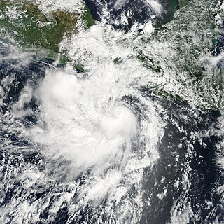
Hurricane Cosme caused flooding along the Pacific coast of Mexico in June 2013. The third named tropical cyclone of the 2013 Pacific hurricane season, the storm system formed from a tropical wave south of Manzanillo, Colima, on June 23. The cyclone intensified into a tropical storm on June 24, and soon after strengthened into a hurricane on June 25. Early the following day, Cosme attained its peak intensity as a Category 1 hurricane on the Saffir–Simpson scale with maximum sustained winds of 85 mph (140 km/h) and a minimum barometric pressure of 980 mbar. However, Cosme then began to encounter stable air and lower sea surface temperatures, causing the system to weaken to a tropical storm late on June 26. The system continued to weaken and degenerated into a remnant low pressure surface trough about 690 mi (1,110 km) west-southwest of Cabo San Lucas, Mexico, on June 27. The remnants persisted until dissipating well east-southeast of the Hawaiian Islands on July 1.
Hurricane Carlos was an unusually small tropical cyclone which affected the western coast of Mexico in June 2015. Forming as the third named storm and hurricane of the annual hurricane season, Carlos developed from a trough first noted by the National Hurricane Center on June 7. The disturbance gradually organized and was designated as a tropical depression three days later while south of the Mexican Pacific coast. Drifting slowly northwestward, the depression was upgraded further to a tropical storm. Although persistent wind shear and dry air hampered intensification early on, Carlos strengthened into a hurricane on June 13 after moving into a more favorable environment. However, the return of dry air and upwelling of cooler waters caused the system to deteriorate into a tropical storm. Paralleling the Mexican coast, Carlos later regained hurricane intensity on June 15 and attained peak winds of 90 mph (140 km/h) a day later. The reprieve was brief, however, as the onset of wind shear, land interaction, and dry air afterward led to rapid weakening. On June 17, Carlos degenerated into a remnant area of low pressure, having made landfall in Jalisco earlier that day. By the morning of June 18, Carlos was declared to have completely dissipated.

Hurricane Max was a rapidly-forming tropical cyclone that made landfall in southwestern Mexico, causing minor damage. The sixteenth tropical cyclone, thirteenth named storm, and seventh hurricane of the 2017 Pacific hurricane season, Max developed from a trough of low pressure near the southwestern coast of Mexico on September 13. The storm tracked northeastward under the influence of a mid-level ridge and rapidly strengthened as a result of warm ocean temperatures in its path. Max strengthened into a hurricane on September 14 and peaked as a high-end Category 1 hurricane on the Saffir–Simpson scale shortly before making landfall in the Mexican state of Guerrero. Rapid weakening ensued as Max moved over the mountainous terrain of Mexico, and it weakened below hurricane strength early on September 15. At 12:00 UTC that day, Max dissipated over the mountains of southern Mexico.

The 2022 Pacific hurricane season was an active hurricane season in the eastern North Pacific basin, with nineteen named storms, ten hurricanes, and four major hurricanes. Two of the storms crossed into the basin from the Atlantic. In the central North Pacific basin, no tropical cyclones formed. The season officially began on May 15 in the eastern Pacific, and on June 1 in the central; both ended on November 30. These dates historically describe the period each year when most tropical cyclogenesis occurs in these regions of the Pacific and are adopted by convention.

Tropical Storm Narda was a short-lived tropical storm that remained close to the Pacific coast of Mexico, causing flash flooding and mudslides in southwestern Mexico and the Baja California Peninsula in late September 2019. The fourteenth named storm of the 2019 Pacific hurricane season, Narda developed from a broad area of low pressure that formed off the Central American Pacific coast on September 26. The broad low gradually organized as it moved west-northwestward, and it became Tropical Storm Narda early on September 29 while located off the southern coast of Mexico. The cyclone strengthened slightly before it moved inland near Manzanillo. Narda weakened to a tropical depression after moving inland, but restrengthened into a tropical storm on September 30 as it emerged over the Pacific Ocean just south of the Gulf of California. Narda quickly strengthened, and reached its peak intensity with winds of 50 mph (85 km/h) that day before making a second landfall along the northwestern coast of Mexico. The tropical cyclone weakened rapidly as it moved along the coastline, and it weakened to a tropical depression before dissipating just off the coast of Sonora on October 1.
Hurricane Rick was the fifth named storm and fourth hurricane to make landfall along the Pacific coast of Mexico in 2021. The seventeenth named system and the eighth hurricane of the 2021 Pacific hurricane season, Rick formed as a low pressure system and was quickly upgraded to a tropical depression on October 21. Late on October 22, the storm was designated as a tropical storm and was given the name Rick. A few hours later, on October 23, the storm was upgraded to a hurricane. Rick continued to intensify and reached peak intensity early on October 25, making landfall as a Category 2 hurricane at 10:00 UTC that morning.