
The 2007 Pacific typhoon season was a below average season which featured 24 named storms, fourteen typhoons, and five super typhoons. It was an event in the annual cycle of tropical cyclone formation, in which tropical cyclones form in the western Pacific Ocean. The season ran throughout 2007, though most tropical cyclones typically develop between May and November. The season's first named storm, Kong-rey, developed on March 30, while the season's last named storm, Mitag, dissipated on November 27. The season's first typhoon, Yutu, reached typhoon status on May 18, and became the first super typhoon of the year on the next day.

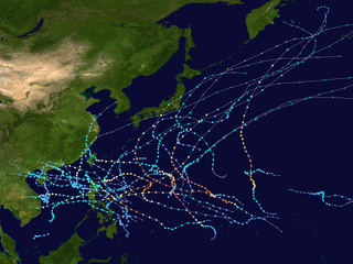
The 2008 Pacific typhoon season was a below average season which featured 22 named storms, eleven typhoons, and two super typhoons. The season had no official bounds; it ran year-round in 2008, but most tropical cyclones tend to form in the northwestern Pacific Ocean between May and November. These dates conventionally delimit the period of each year when most tropical cyclones form in the northwestern Pacific Ocean.

Tropical Storm Mekkhala was recognised as the 16th Tropical Storm of the 2008 Pacific typhoon season by the Japan Meteorological Agency who are the Regional Specialized Meteorological Centre for the North Western Pacific Ocean. The Joint Typhoon Warning Center (JTWC) have also recognised Mekkhala as the 20th tropical depression, and the 18th tropical storm of the 2008 Pacific typhoon season.
This timeline documents all the storm formations, strengthening, weakening, landfalls, extratropical transitions, as well as dissipation during the 2008 Pacific typhoon season. The 2008 Pacific typhoon season officially started on January 1, 2008 and ended on January 1, 2009. The first tropical cyclone of the season formed on January 13. The timeline also includes information which was not operationally released, meaning that information from post-storm reviews by the various warning agencies, such as information on a storm that was not operationally warned on, has been included.

Typhoon Fung-wong, known in the Philippines as Typhoon Igme, was a deadly typhoon in the 2008 Pacific typhoon season which made landfall on Taiwan and China. Typhoon Fung-wong reached peak intensity of a Category 2 typhoon on the Saffir-Simpson Hurricane Scale by the Joint Typhoon Warning Center with peak winds of 95 knots (176 km/h). Damage was extensive in Taiwan, hitting little more than a week later than Typhoon Kalmaegi, but a specific cost is unknown, though later estimated at 541 million.

Typhoon Rammasun, known in the Philippines as Typhoon Butchoy, was recognized as the second typhoon of the 2008 Pacific typhoon season by the Japan Meteorological Agency (JMA) and the Philippine Atmospheric, Geophysical and Astronomical Services Administration (PAGASA). Rammasun was also recognised as the third tropical storm, the second typhoon and the first super typhoon of the 2008 Pacific typhoon season by the Joint Typhoon Warning Center (JTWC).

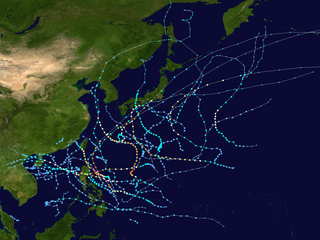
The 2012 Pacific typhoon season was a slightly below average but destructive season, though rather active since 2004. It produced 25 named storms, fourteen typhoons, and four intense typhoons. It was an event in the annual cycle of tropical cyclone formation, in which tropical cyclones form in the western Pacific Ocean. The season ran throughout 2012, though most tropical cyclones typically develop between May and October. The season's first named storm, Pakhar, developed on March 28, while the season's last named storm, Wukong, dissipated on December 29. The season's first typhoon, Guchol, reached typhoon status on June 15, and became the first super typhoon of the year on June 17.

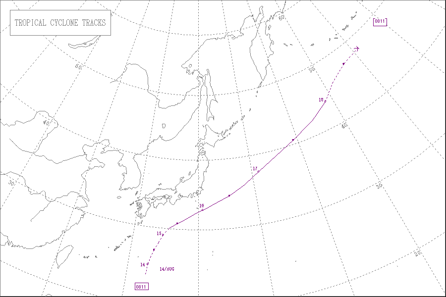
Severe Tropical Storm Maysak, known in the Philippines as Tropical Storm Quinta-Siony, was recognised as the 19th tropical storm by the Japan Meteorological Agency. It was also recognised as the 24th tropical depression and the 22nd tropical storm by the Joint Typhoon Warning Center of the 2008 Pacific typhoon season.
The 2009 Pacific typhoon season was a below average season that spawned only 22 named storms, 13 typhoons, and five super typhoons. It was also recognized as the deadliest season in the Philippines for decades. The first half of the season was very quiet whereas the second half of the season was extremely active. The season's first named storm, Kujira, developed on May 3 while the season's last named storm, Nida, dissipated on December 3.
Typhoon Dolphin, known in the Philippines as Typhoon Ulysses, was the final named storm and typhoon of the 2008 Pacific typhoon season. The only impact that was reported from Dolphin was to the M/Bca Mae Jan, which was a cargo passenger ship which sank on December 14, due to rough seas caused by Dolphin. There were 46 people reported dead while seven were reported as missing.
The 2010 Pacific typhoon season was the least active Pacific typhoon season on record, featuring only 14 named storms; seven of them strengthened into typhoons while one reached super typhoon intensity. The Pacific typhoon season during 2010 was in fact less active than the 2010 Atlantic hurricane season, the only such occurrence other than 2005. In the same year, the Pacific hurricane season broke the same record being the least active season on record. During the season, no storms made landfall in mainland Japan, the only second such occurrence since 1988. Also, all of the 14 named storms developed west of 150°E.
This timeline documents all of the events of the 2009 Pacific typhoon season which was the period that tropical cyclones formed in the Western Pacific Ocean during 2009, with most of the tropical cyclones forming between May and November. The scope of this article is limited to the Pacific Ocean, north of the equator between 100°E and the International Date Line. Tropical storms that form in the entire Western Pacific basin are assigned a name by the Japan Meteorological Agency. Tropical depressions that form in this basin are given a number with a "W" suffix by the United States' Joint Typhoon Warning Center. In addition, the Philippine Atmospheric, Geophysical and Astronomical Services Administration (PAGASA) assigns names to tropical cyclones that enter or form in the Philippine area of responsibility. These names, however, are not in common use outside of the Philippines.
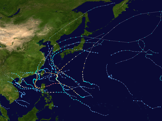
The 2011 Pacific typhoon season was a below average season that produced a total of 21 named storms, 8 typhoons, and four super typhoons. This season was much more active than the previous season, although both seasons were below the Pacific typhoon average of 26. The season ran throughout 2011, though most tropical cyclone tend to develop between May and October. The season's first named storm, Aere, developed on May 7 while the season's last named storm, Washi dissipated on December 19.

The 2014 Pacific typhoon season was a slightly below average season, featuring 23 tropical storms, 11 typhoons, 8 super typhoons, and 7 Category 5 typhoons. The season's peak months August and September saw minimal activity caused by an unusually strong and a persistent suppressing phase of the Madden–Julian oscillation (MJO). The season ran throughout 2014, though most tropical cyclones typically develop between May and October. The season began with the development of Tropical Storm Lingling on January 18, and ended after Tropical Storm Jangmi which dissipated on January 1 of the next year.

The 2020 Pacific typhoon season is an event in the annual cycle of tropical cyclone formation in which tropical cyclones form in the western Pacific Ocean. The season runs throughout the year, though most tropical cyclones typically develop between May and October. The first half of the season was unusually inactive, with only four systems, two named storms and one typhoon at the end of July. Additionally, the JTWC recorded no tropical cyclone development in the month of July, the first such occurrence since reliable records began. The season's first tropical cyclone developed on May 8, making it the fifth-latest start in the basin on record, slightly behind 1973, and the first to start this late since 2016. The 2020 Pacific typhoon season is less active than the 2020 Atlantic hurricane season so far, which has only happened twice before: in 2010 and 2005.
This timeline documents all of the events of the 2011 Pacific typhoon season, the period that tropical cyclones formed in the Western Pacific Ocean in 2011. Most of the tropical cyclones formed between May and November 2011. The scope of this article is limited to the Pacific Ocean, north of the equator between 100°E and the International Date Line. Tropical storms that form in the entire Western Pacific basin are assigned a name by the Japan Meteorological Agency (JMA). Tropical depressions that form in this basin are given a number with a "W" suffix by the United States' Joint Typhoon Warning Center (JTWC). In addition, the Philippine Atmospheric, Geophysical and Astronomical Services Administration (PAGASA) assigns names to tropical cyclones that enter or form in the Philippine area of responsibility. These names, however, are not in common use outside of the Philippines.
This timeline documents all of the events of the 2014 Pacific typhoon season. Most of the tropical cyclones forming between May and November. The scope of this article is limited to the Pacific Ocean, north of the equator between 100°E and the International Date Line. Tropical storms that form in the entire Western Pacific basin are assigned a name by the Japan Meteorological Agency. Tropical depressions that form in this basin are given a number with a "W" suffix by the United States' Joint Typhoon Warning Center. In addition, the Philippine Atmospheric, Geophysical and Astronomical Services Administration (PAGASA) assigns names to tropical cyclones that enter or form in the Philippine area of responsibility. These names, however, are not in common use outside of the Philippines.
This timeline documents all of the events of the 2012 Pacific typhoon season, the period that tropical cyclones formed in the Western Pacific Ocean during 2012. Most of these tropical cyclones formed between May and November 2012. The scope of this article is limited to the Pacific Ocean, north of the equator between 100°E and the International Date Line. Tropical storms that form in the entire Western Pacific basin are assigned a name by the Japan Meteorological Agency (JMA). Tropical depressions that form in this basin are given a number with a "W" suffix by the United States' Joint Typhoon Warning Center (JTWC). In addition, the Philippine Atmospheric, Geophysical and Astronomical Services Administration (PAGASA) assigns names to tropical cyclones that enter or form in the Philippine area of responsibility. These names, however, are not in common use outside of the Philippines.

Typhoon Vongfong, known in the Philippines as Typhoon Ompong, was the most intense tropical cyclone worldwide in 2014, and struck Japan as a large tropical system. It also indirectly affected the Philippines and Taiwan. Vongfong was the nineteenth named storm and the ninth typhoon of the 2014 Pacific typhoon season. Estimates assess damage from Vongfong to have been over US$160 million, mainly for striking mainland Japan. At least 9 people were killed along the path of the typhoon in those countries.

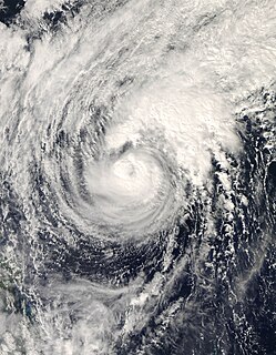
Typhoon Nuri, known in the Philippines as Typhoon Paeng, was the third most intense tropical cyclone worldwide in 2014. Nuri developed into a tropical storm and received the name Paeng from the PAGASA on October 31, before it intensified into a typhoon on the next day. Under excellent conditions, especially the synoptic scale outflow, Nuri underwent rapid deepening and reached its peak intensity on November 2, forming a round eye in a symmetric Central dense overcast (CDO). Having maintained the impressive structure for over one day, the typhoon began to weaken on November 4, with a cloud-filled eye.


