Kirby is an unincorporated census-designated place in northern Pike County, Arkansas, United States. The community lies on U.S. Route 70; it is located halfway between Daisy and Glenwood. Per the 2020 census, the population was 721.
Genoa is an unincorporated community and census-designated place (CDP) in Miller County, Arkansas, United States. It was first listed as a CDP in the 2020 census with a population of 972. It is located 6 to 12 miles east of Texarkana along Highway 196. Although unincorporated, Genoa has a post office, with the ZIP code of 71840 for a specific post office box. Most of the community is served by ZIP code 71854 (Texarkana). Genoa also has its own school district, Genoa Central School District.
Magnet Cove is a census-designated place (CDP) and former town in Hot Spring County, Arkansas, United States. It is located in the Ouachita Mountains southeast of Hot Springs, on Arkansas Highway 51 north of U.S. Highway 270. As of the 2020 census, the town of Magnet Cove had a population of 692.

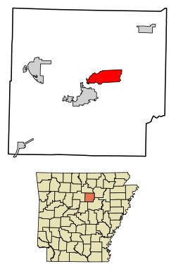
Center Ridge is an unincorporated census-designated place in Conway County, Arkansas, United States. Per the 2020 census, the population was 2,235.

Roland is a census-designated place in Pulaski County, Arkansas, United States. It is part of the Central Arkansas metropolitan area. Per the 2020 census, the population was 820.

Cherokee City is an unincorporated census-designated place (CDP) in Benton County, Arkansas, United States. Per the 2020 census, the population was 73. It is the location of Coon Creek Bridge, which is located on Cty Rd. 24 and is listed on the National Register of Historic Places. The community was named for the Cherokee, since the Trail of Tears crossed the landscape when the Cherokee migrated west to Indian territory, now Oklahoma in the late 1830s. The town is within the Northwest Arkansas region, located about 5 miles east of Oklahoma and 4 miles south of the Missouri state line.
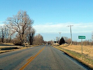
Maysville is an unincorporated community and census-designated place (CDP) in Benton County, Arkansas, United States. It is the westernmost settlement in the state of Arkansas. Per the 2020 census, the population was 117. It is located in the Northwest Arkansas region.

New Blaine is an unincorporated community and census-designated place (CDP) in Logan County, Arkansas, United States. Per the 2020 census, the population was 173.
Midway is a census-designated place in Baxter County, Arkansas, United States. Midway is 5.5 miles (8.9 km) northwest of Mountain Home. Per the 2020 census, the population was 1,036. Midway has a post office with ZIP code 72651. Long home to a rural trading post, Midway became a boomtown during the construction of the Bull Shoals Dam, and later evolved to serve tourists and retirees attracted to the lake.
Oak Grove is an unincorporated community and census-designated place (CDP) in Moreland Township, Pope County, Arkansas, United States. It was first listed as a CDP in the 2020 census with a population of 177.
Drasco is an unincorporated community and census-designated place (CDP) in Cleburne County, Arkansas, United States, with a ZIP code of 72530. Drasco lies just northeast of Greers Ferry Lake and includes the lakeside community of Tannenbaum.

Avilla is a census-designated place in Saline County, Arkansas, United States. Per the 2020 census, the population was 1,325.

Hagarville is a census-designated place in Johnson County, Arkansas, United States. Per the 2020 census, the population was 142.

Lost Bridge Village is a residential subdivision near the town of Garfield in Benton County, Arkansas, United States. Per the 2020 census, the population was 397. It is located in the Northwest Arkansas region.

Rye is a census-designated place in Cleveland County, Arkansas, United States. Per the 2020 census, the population was 123.

Staves is a census-designated place in Cleveland County, Arkansas, United States. Per the 2020 census, the population was 133.
Woodlawn is a census-designated place in Cleveland County, Arkansas, United States. Per the 2020 census, the population was 174.
Oakland is an unincorporated community and census-designated place (CDP) in northeastern Marion County, Arkansas, United States. Oakland, located on Arkansas Highway 202, is 20 miles (32 km) by road northwest of Mountain Home. Oakland has a post office with ZIP code 72661. The Oakland Campground on Bull Shoals Lake lies about three miles to the west at the end of Route 202. It was first listed as a CDP in the 2020 census, with a population of 72.
Edgemont is an unincorporated community and census-designated place (CDP) in Cleburne County, Arkansas, United States. Edgemont is located on the north side of Greers Ferry Lake along Arkansas Highway 16, 2 miles (3.2 km) northwest of Greers Ferry. Edgemont has a post office with ZIP code 72044.
Wilburn is an unincorporated community and census-designated place (CDP) in Cleburne County, Arkansas, United States. Wilburn is located on Arkansas Highway 110, 8 miles (13 km) east of Heber Springs. Wilburn has a post office with ZIP code 72179.