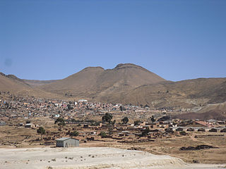
Paquni is a 4,838-metre-high (15,873 ft) mountain in the Potosí Department of Bolivia. It is located in the Antonio Quijarro Province, Tomave Municipality, northeast of the Jatun Mundo Quri Warani volcano.

Llallagua or Llallawa is a town in the Potosí Department in Bolivia. It is the seat of the Llallagua Municipality, the third municipal section of the Rafael Bustillo Province.

Kimsa Kunturiri is a group of three mountains in the Andes of Bolivia in the Potosí Department at the border of Tomás Frías Province and Cornelio Saavedra Province. The peaks are about 5,020 m, 4,980 m and 4,960 m high. The Kimsa Kunturiri group is situated in the Khari Khari mountain range east of Potosí. It lies north of the Kimsa Waylla group, between the lakes Jatun Wak'ani (Jatun Huacani) and Juch'uy Wak'ani (Juchuy Huacani) in the west and the Jatun Tiyu Lakes in the east.

Uma Jalanta is a mountain in the Khari Khari mountain range of the Bolivian Andes, about 4,760 m (15,617 ft) high. It is situated south east of Potosí in the Potosí Department, Tomás Frías Province, Potosí Municipality. Uma Jalanta lies north-east of Challwiri Lake and the mountain Illimani.

Sirk'i is a 5,108-metre-high (16,759 ft) mountain in the Andes of Bolivia. It is situated in the Potosí Department, Antonio Quijarro Province, Tomave Municipality, about 14 km north of the Jatun Mundo Quri Warani volcano. Sirk'i lies southwest of Kunturiri Mayqu and west of Ch'iyar Jaqhi.

Qutapata is a 5,300-metre-high (17,388 ft) mountain in the Cordillera Real in the Bolivian Andes. It is situated in the La Paz Department, Sud Yungas Province, Irupana Municipality, near the border with the Murillo Province, Palca Municipality. Qutapata lies south-west of the mountain Mururata and north-east of the mountain Wila Quta.

Sura Qullu is a 4,752-metre-high (15,591 ft) mountain in the Cordillera Real in the Bolivian Andes. It is situated in the La Paz Department, Sud Yungas Province, Yanacachi Municipality, north-east of the city of La Paz. Sura Qullu lies between the mountain Jathi Qullu in the north-west and the lake Warawarani in the south-east.

Wak'ani is a mountain in the Khari Khari mountain range in the Andes of Bolivia. It is situated in the Potosí Department, Tomás Frías Province, east of Potosí. Wak'ani lies south and south-west of the mountains Khari Khari and Kimsa Waylla, north-west of the mountain Illimani and south-east of the Khari Khari Lakes.

Suri Phuyu is a 5,458-metre-high (17,907 ft) mountain in the Cordillera Occidental in the Bolivian Andes. It is located in the Potosí Department, Sur Lípez Province, San Pablo de Lípez Municipality. Suri Phuyu lies within the borders of the Eduardo Avaroa Andean Fauna National Reserve. It is situated southwest of the Uturunku volcano at the Challwiri salt flat, northeast of it.

P'ukru or Phujru is a 4,768-metre-high (15,643 ft) mountain in the Potosí mountain range in the Bolivian Andes. It is situated in the Potosí Department, Tomás Frías Province, in the south of the Potosí Municipality. P'ukru lies southwest of Khunurana and a mountain named Q'umir Qucha.

Waylla Tira is a 4,324-metre-high (14,186 ft) mountain in the Andes of Bolivia. It is located in the Potosí Department, Tomás Frías Province, Potosí Municipality. Waylla Tira lies east of the Challwiri River, an affluent of the Pillku Mayu.
Janq'u Qullu may refer to:

Chuqi Warani is a 5,388-metre-high (17,677 ft) mountain in Bolivia. It is located in the Potosí Department, Antonio Quijarro Province, Tomave Municipality. It lies southwest of the Jatun Mundo Quri Warani volcano. In the map of the Bolivian Instituto Geográfico Militar the term Chaupi Mundo is added under Cerro Choquehuarani. This may be an alternate name or a supplement.

Wila Salla is a 4,784-metre-high (15,696 ft) mountain in the Andes of Bolivia. It is located in the Potosí Department, Tomás Frías Province, on the border of the municipalities of Tinguipaya and Yocalla.

Muru Qullu is a 4,613-metre-high (15,135 ft) mountain in Bolivia. It is located in the Potosí Department, Antonio Quijarro Province, Porco Municipality. It lies southwest of Warawara Lake.

Katariri is a 3,224 m (10,577 ft) high a mountain in the Bolivian Andes. It is located on the border of the Chuquisaca Department, Oropeza Province, Poroma Municipality, and the Potosí Department, Chayanta Province, Ravelo Municipality. It lies northeast of Chullpa Urqu

Lluxita is a mountain in the Bolivian Andes which reaches a height of approximately 4,100 m (13,500 ft). It is located in the Potosí Department, Chayanta Province, Ocurí Municipality. It lies southeast of the village of Ch'aki Mayu (Chaqui Mayu).

Phujuni is a mountain in the Bolivian Andes which reaches a height of approximately 4,740 m (15,550 ft). It is located in the Potosí Department, Antonio Quijarro Province, Porco Municipality. It lies northwest of K'uyka and northeast of Qullqi Chaka Punta.

T'ula Qullu is a mountain in the Bolivian Andes which reaches a height of approximately 4,560 m (14,960 ft). It is located in the Potosí Department, Tomás Frías Province, Potosí Municipality. It lies southwest of Cerro Rico and east of Qutaña Qullu.

Waylla Qullu is a mountain in the Bolivian Andes which reaches a height of approximately 3,740 m (12,270 ft). It is located in the Potosí Department, Tomás Frías Province, Yocalla Municipality.


