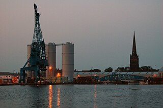
Goole is a port, market town and civil parish in the East Riding of Yorkshire, England. The town was historically within the West Riding of Yorkshire. Goole lies 19 miles (31 km) south of York and 29 miles (47 km) west of Hull.

Airmyn is a village and civil parish in the East Riding of Yorkshire, England. It is situated at the mouth of the River Aire with the River Ouse, approximately 2 miles (3.2 km) north-west of Goole. It lies to the west of the M62 motorway and the A614 road. According to the 2011 UK census, Airmyn parish had a population of 768, a fall from the 2001 UK census figure of 795. The parish covers an area of 1,155.353 hectares.

Rawcliffe is a village and civil parish in the East Riding of Yorkshire, England. It is situated approximately 4 miles (6.4 km) west of Goole. It lies on the banks of the River Aire just north of the M62 and on the A614 road. Rawcliffe, along with nearby Airmyn, was the location of one of the first reliable reports of the practice of warping in agriculture in the 1730s.

Anlaby with Anlaby Common is a civil parish in the East Riding of Yorkshire, England. The parish includes the village suburb of Anlaby and the part of the area known as Anlaby Common.

Asselby is a village and civil parish in the East Riding of Yorkshire, England. It is located in the south-west of the county, north of the River Ouse. It is situated approximately 2 miles (3.2 km) west of the market town of Howden. The land surrounding Asselby is very flat and intersected by dykes which drain into the Rivers Aire and Ouse.

Boynton is a village and civil parish in the East Riding of Yorkshire, England. It is situated approximately 3 miles (5 km) west of the town of Bridlington and lies on the B1253 road.
Snaith is a town in the East Riding of Yorkshire, England, approximately 6 miles (10 km) west of Goole on the A1041 at its junction with the A645. It is 1 mile (1.6 km) to the north of the M62 motorway, just south of the River Aire.

Whitgift is a small linear village in the East Riding of Yorkshire, England approximately 4 miles (6.4 km) east of Goole. It is located alongside the River Ouse and north of the A161 road between Goole and Scunthorpe. Ousefleet and Reedness are to the east and west respectively. It forms part of the civil parish of Twin Rivers. Historically Whitgift was part of the West Riding of Yorkshire.
Swinefleet is a village and civil parish in the East Riding of Yorkshire, England. It is situated approximately 2 miles (3.2 km) south-east of the town of Goole on the A161 road from Goole to Crowle. It lies on the south bank of the River Ouse. According to the 2011 UK census, Swinefleet parish had a population of 787, an increase on the 2001 UK census figure of 748. The main centre of population is at the extreme north of the parish, close to the River Ouse. The southern part of the parish is part of Swinefleet and Reedness Moors, and is characterised by drainage ditches and a few farm buildings.

For people with the surname, see Sancton (surname).
Reedness is a village and civil parish in the East Riding of Yorkshire, England. It is situated approximately 3 miles (4.8 km) east of the town of Goole and lies on the south bank of the River Ouse.
Pollington is a village and civil parish in the East Riding of Yorkshire, England. It is situated approximately 2 miles (3.2 km) south-west of the town of Snaith and 1 mile (1.6 km) south of the M62 motorway. It lies on the north bank of the Aire and Calder Navigation.
Ousefleet is a small hamlet in the East Riding of Yorkshire, England approximately 5 miles (8 km) east of Goole. It is located just south of the River Ouse and north of the A161 road between Goole and Scunthorpe. It forms part of the civil parish of Twin Rivers.

Catton is a civil parish in the East Riding of Yorkshire, England. It is situated 6 miles (10 km) to the north-west of the market town of Pocklington and covering an area of 1,233 hectares . It lies on the east bank of the River Derwent that forms the boundary with the unitary authority of the City of York. The A1079 road crosses the river just north of Kexby Bridge which is designated a Grade II* listed building in and is now recorded in the National Heritage List for England, maintained by Historic England.

Kilpin is a village and civil parish in the East Riding of Yorkshire, England. It is situated approximately 1.5 miles (2.4 km) south-east of Howden and 18 miles (29 km) south-east from the county town of York.

Hook is a village and civil parish in the East Riding of Yorkshire, England. It is situated approximately 1.5 miles (2.4 km) north-east of Goole town centre and lies on the west bank of the River Ouse.

Gowdall is a village and civil parish in the East Riding of Yorkshire, England. It is situated approximately 1 mile (1.6 km) west of the town of Snaith, 1 mile to the north of the M62 motorway and the A645 road, and just south of the River Aire.

Goole Fields is a civil parish in the East Riding of Yorkshire, England. It is situated approximately 3 miles (4.8 km) south-west of Goole town centre and lies at both sides but mainly south of the A161 road, covering an area of 1,980.59 hectares. It is bordered to the east by the Swinefleet Warping Drain, to the south by the Blackwater Dike, and to the west by the railway line from Goole to Doncaster.

Snaith and Cowick is a civil parish in the East Riding of Yorkshire, England. It is situated approximately 6 miles (9.7 km) west of the town of Goole and covers an area of 2,406.612 hectares.

East Cottingwith is a village and former civil parish, now in the parish of Cottingwith, East Riding of Yorkshire, England. It lies on the former Derwent Navigation (canal), and approximately 9 miles (14 km) north-west of the market town of Howden and 7 miles (11 km) south-west of the market town of Pocklington. The village is 1 mile (1.6 km) west of the B1228 road and just east of the River Derwent. In 1931 the civil parish had a population of 185. On 1 April 1935 the civil parish was merged with Storwood to create Cottingwith.
