This article needs additional citations for verification .(June 2012) |

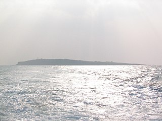
The Two Brothers Rocks (Italian: Scoglio Due Fratelli; Sicilian I Ru' Frati) are a rock formation in the Ionian Sea to the north-east of Syracuse in Sicily. [1]
This article needs additional citations for verification .(June 2012) |
The Two Brothers Rocks (Italian: Scoglio Due Fratelli; Sicilian I Ru' Frati) are a rock formation in the Ionian Sea to the north-east of Syracuse in Sicily. [1]
The two rocks are located between the districts of Grottasanta, Mazzarona and Tunis Avenue, in a bay called "Coast of Piliceddi". The coasts in the area are jagged, except for a small beach formed by the disintegration of the rocks. The depth of the sea does not exceed 20 meters.
Three versions:
Both the flora and fauna are typical of the Mediterranean. There are several species of aquatic plants, mostly neptune grass. The fauna is composed of crabs, shellfish, sea urchins, octopus, starfish, fish of various species, moray eels, and there can be stingrays. In 2005, there was an influx of jellyfish, mostly Pelagia noctiluca. Other seaside towns saw an increase in jellyfish. The Pelagia noctiluca is very irritating and has hurt many people whom have tried to swim.
Tourism is mainly present in the summer, between the months of June and September. The tourists who come to visit this place are particularly attracted by the beauty of the sea and the landscape of jagged cliffs. There are boat tours driven by professionals, which take tourists to visit the sea and rocks. The tour, lasting about half an hour, begins from the island of Ortigia, then passes from the coast of sea grottoes of Syracuse, and finally arrives at the "Two Brothers", where it stops for a few minutes to give tourists the possibility to swim. Afterward, they repeated the same round, bringing the tourists to Ortigia.
This is a particularly suitable place to spend some time in contact with marine nature, repose and also for fun. The two rocks are also a great place for diving. There is also practiced spearfishing, given the abundance of the fauna.
The two rocks are accessible through the Via Sicilia, situated in the district of Grottasanta. Going from this to its end, and turning right, there is a destroyed wall, and immediately after the bike path. After this there is a large lawn by Mediterranean, bounded by cliffs overlooking the sea ("Coast of Piliceddi"), and from there the two rocks are visible. Walking centrally towards the cliff, you will reach a cliff with a short, steep descent, where you can see the stairs carved into the rock of ancient origin. Going down toward the reef closest to the sea, one arrives at a small peninsula, where the rocks of "Two Brothers" are only accessible by the sea. Somewhere between the mainland and the rocks there are around 60 meters of distance.

Kythira, also transliterated as Cythera, Kythera and Kithira, is an island in Greece lying opposite the south-eastern tip of the Peloponnese peninsula. It is traditionally listed as one of the seven main Ionian Islands, although it is distant from the main group. Administratively, it belongs to the Islands regional unit, which is part of the Attica region, despite its distance from the Saronic Islands, around which the rest of Attica is centered. As a municipality, it includes the island of Antikythera to the south.

Ponza is the largest island of the Italian Pontine Islands archipelago, located 33 km (21 mi) south of Cape Circeo in the Tyrrhenian Sea. It is also the name of the commune of the island, a part of the province of Latina in the Lazio region.

Margarita Island is the largest island in the Venezuelan state of Nueva Esparta, situated off the north west coast of the country, in the Sea. The capital city of Nueva Esparta, La Asunción, is located on the island.

St Abb's Head is a rocky promontory by the village of St Abbs in Scottish Borders, Scotland, and a national nature reserve administered by the National Trust for Scotland. St Abb's Head Lighthouse was designed and built by the brothers David Stevenson and Thomas Stevenson and began service on 24 February 1862.

Elephanta Island is one of a number of islands in Mumbai Harbour, east of Mumbai, India.

Ortygia is a small island which is the historical centre of the city of Syracuse, Sicily. The island, also known as the Città Vecchia, contains many historical landmarks.

Meloria is a rocky skerry, surrounded by a shoal, off the Tuscan coast, in the Ligurian Sea, 6.1 kilometres (3.8 mi) north-west of Livorno.

Dongyin Township (Tungyin) is an insular rural township which is part of Lienchiang County, Fujian Province, Republic of China (Taiwan). The islands are in the East China Sea off the coast of Fujian Province, China near the cities of Fuzhou (Foochow) and Ningde. The township is known for its natural environment and Eastern Min culture, for the historical Dongyong Lighthouse and for its military importance and history as the northernmost territory of Taiwan.

Tokunoshima, also known in English as Tokuno Island, is an island in the Amami archipelago of the southern Satsunan Islands of Kagoshima Prefecture, Japan.

Jellyfish Lake is a marine lake located on Eil Malk island in Palau. Eil Malk is a part of the Rock Islands, a group of small, rocky, mostly uninhabited islands in Palau's Southern Lagoon, between Koror and Peleliu. There are about 70 other marine lakes located throughout the Rock Islands. Millions of golden jellyfish migrate horizontally across the lake daily.

Pelagia noctiluca is a jellyfish in the family Pelagiidae and the only currently recognized species in the genus Pelagia. It is typically known in English as the mauve stinger, but other common names are purple-striped jelly, purple stinger, purple people eater, purple jellyfish, luminous jellyfish and night-light jellyfish. In Greek, pelagia means "(she) of the sea", from pelagos "sea, open sea"; in Latin noctiluca is the combining form of nox, "night"", and lux, "light"; thus, Pelagia noctiluca can be described as a marine organism with the ability to glow in the dark (bioluminescence). It is found worldwide in tropical and warm temperate seas, although it is suspected that records outside the North Atlantic region, which includes the Mediterranean and Gulf of Mexico, represent closely related but currently unrecognized species.
Marado (Korean: 마라도) or Mara Island is an island in Jeju Province, South Korea. It is South Korea's southernmost island, and is 8 km (5.0 mi) off the south coast of Jeju Island.
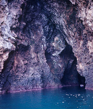
A sea cave, is also known as a littoral cave, a type of cave formed primarily by the wave action of the sea. The primary process involved is erosion. Sea caves are found throughout the world, actively forming along present coastlines and as relict sea caves on former coastlines. Some of the largest wave-cut caves in the world are found on the coast of Norway, but are now 100 feet or more above present sea level. These would still be classified as littoral caves. By contrast, in places like Thailand's Phang Nga Bay, solutionally formed caves in limestone have been flooded by the rising sea and are now subject to littoral erosion, representing a new phase of their enlargement.

Gasparillo is a small island in the Republic of Trinidad and Tobago. It is one of the Bocas Islands, which lie in the Bocas del Dragón between the main island of Trinidad and Venezuela. The island is currently uninhabited.

San Andrés is a coral island in the Caribbean Sea. Politically part of Colombia, and historically tied to the United Kingdom, San Andrés and the nearby islands of Providencia and Santa Catalina form part of the department of San Andrés, Providencia and Santa Catalina; or The Raizal Islands. San Andrés, in the southern group of islands, is the largest of Colombia. The official languages of the department are Spanish, English, and San Andrés–Providencia Creole.

On 15 December 2010, an Indonesian fishing boat carrying 89 asylum seekers and 3 crew members sank after being dashed against the rocks near Rocky Point, Christmas Island, an external Australian territory. 50 people died and 42 were rescued. The incident was the worst civilian maritime disaster in Australia in more than a century.
Helligdomsklipperne are a group of rocks on the island of Bornholm, Denmark, 6 kilometres (3.7 mi) from Gudhjem and 4.9 kilometres (3.0 mi) from Tejn. They are characterised by moderately high coastal cliffs of sharp granite and are about 22 metres (72 ft) high. The name of the rocks originated in the Middle Ages when there was a holy spring close to the coast which attracted pilgrims, especially on Sankt Hans Aften. During the ice age, much of today's coast was below sea level but when the ice melted, the island itself was raised leaving this part of Bornholm's coast some 20 meters above sea level. Coastal cliffs with deep caves and steep craggy granite pillars are typical of this area of the coast as a result of many years exposure to the weather. To the southeast the Kyststi or coastal path leads to the well preserved Døndalen Woods. It is a popular tourist attraction, accessed by boats from Gudhjem harbour. Steps lead from the coast up to the Bornholm Art Museum.
Kinatarkan, also spelled as Kinatarcan and also known as Guintarcan, is an island of the province of Cebu in the Philippines. It lies about 25 kilometres off the west coast of Cebu and 12 kilometres (7 mi) northeast from Bantayan Island. The island is within the municipality of Santa Fe and comprises three barangays: Hagdan, Kinatarkan and Langub.

Dino is the larger of the two small islands in the Tyrrhenian Sea, off the coast of Calabria. The island is situated off Cape Arena, near to Praia a Mare. The name of the island either derives from Italian aedina, a temple, or Greek dino, a vortex or storm.

Gordon's Bay, otherwise known as Thompson's Bay, is a beach within the Eastern Suburbs of Sydney, Australia, located between Clovelly and Coogee beach. It is a site on Sydney's Coastal Walks with scenic views between two rocky headlands. The bay is renowned for various reef and coral and as a result is a popular snorkeling area with an abundance of marine life. It is also known for small aluminium dinghies with an abundance being found upon wooden racks upon the dry sand belonging to members of Gordon's Bay Amateur Fishing Club.
37°05′08″N15°18′06″E / 37.08556°N 15.30167°E