
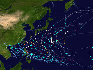
The 2004 Pacific typhoon season was an extremely active season that featured the second-highest ACE ever recorded in a single season, second only to 1997, which featured 29 named storms, nineteen typhoons, and six super typhoons. It was an event in the annual cycle of tropical cyclone formation, in which tropical cyclones form in the western Pacific Ocean. The season ran throughout 2004, though most tropical cyclones typically develop between May and October. The season's first named storm and also the first typhoon, Sudal, developed on April 4, later was reached typhoon status two days later, and became the first super typhoon of the year three days later. The season's last named storm, Noru, dissipated on December 22.

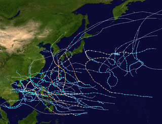
The 1997 Pacific typhoon season was a record-breaking season featuring eleven tropical cyclones reaching super typhoon intensity, tying the record with 1965 with the most intense tropical cyclones globally, and was the ninth and last consecutive year of above-average tropical cyclone activity that started in 1989. Its extremely high activity produced highest ACE index ever index recorded in a single tropical cyclone season. In addition, this season had ten Saffir-Simpson Category 5-equivalent tropical cyclones, the most ever recorded, even greater than the 2005 Atlantic hurricane season, and 2020 Atlantic hurricane season, for Category 4, which had nearly half of the amount. The 1997–98 El Niño event was a contributing factor to this unusually high activity. Despite this, the season produced an average number of tropical storms, spawning 28 tropical storms.

The 1992 Pacific typhoon season was the fourth consecutive above-average season, producing 31 tropical storms, 16 typhoons and five super typhoons. It had no official bounds; it ran year-round in 1992. Despite this, most tropical cyclones tend to form in the northwestern Pacific Ocean between May and November. These dates conventionally delimit the period of each year when most tropical cyclones form in the northwestern Pacific Ocean.

The 1991 Pacific typhoon season was a slightly above-average season with 29 tropical storms, 17 typhoons and five super typhoons forming. It was quite a catastrophic season – Typhoon Yunya impacted the Philippines in mid June while in the same time experiencing a volcanic eruption, Typhoon Mireille severely impacting Japan, which became known for being the costliest typhoon on record until it was surpassed by Typhoon Doksuri in 2023, and Tropical Storm Thelma on November which became one of the deadliest storms to strike the Philippines, killing at least over 5,000 people.
The 1980 Pacific typhoon season was a slightly-below average season when compared to the long-term average, though it featured several intense storms. It ran year-round in 1980, but most tropical cyclones formed between June and December. These dates conventionally delimit the period of each year when most tropical cyclones form in the northwestern Pacific Ocean. A total of 28 tropical depressions formed this year in the Western Pacific, of which 24 became tropical storms and were assigned a name by the Joint Typhoon Warning Center. Beginning in March, tropical cyclones formed in each subsequent month through December. Of the 24 named storms, 15 storms reached typhoon intensity, of which 2 reached super typhoon strength.
The 1970 Pacific typhoon season has no official bounds; it ran year-round in 1970, but most tropical cyclones tend to form in the northwestern Pacific Ocean between June and December. These dates conventionally delimit the period of each year when most tropical cyclones form in the northwestern Pacific Ocean.

The 1964 Pacific typhoon season was the most active tropical cyclone season recorded globally, with a total of 39 tropical storms forming. It had no official bounds; it ran year-round in 1964, but most tropical cyclones tend to form in the northwestern Pacific Ocean between June and December. These dates conventionally delimit the period of each year when most tropical cyclones form in the northwestern Pacific Ocean.

The 1957 Pacific typhoon season has no official bounds; it ran year-round in 1957, but most tropical cyclones tend to form in the northwestern Pacific Ocean between June and December. These dates conventionally delimit the period of each year when most tropical cyclones form in the northwestern Pacific Ocean.

The 1963 Pacific typhoon season has no official bounds; it ran year-round in 1963, but most tropical cyclones tend to form in the northwestern Pacific Ocean between June and December. These dates conventionally delimit the period of each year when most tropical cyclones form in the northwestern Pacific Ocean.

The 1951 Pacific typhoon season was a generally average season with multiple tropical cyclones striking the Philippines. With the exception of January, each month saw at least one tropical system develop; October was the most active month with four tropical cyclones forming. Overall, there were 31 tropical depressions, of which 25 became tropical storms; of those, there were 16 typhoons.
Typhoon Kong-rey was a moderate typhoon that affected Guam and the Northern Mariana Islands in early April 2007. The first named storm of the 2007 Pacific typhoon season, Kong-rey became the earliest-occurring typhoon since Typhoon Sudal in 2004. At its peak, it was considered to be a Category 2-equivalent typhoon by the Joint Typhoon Warning Center, though re-analysis increased it to a Category 3-equivalent. Typhoon Kong-rey caused about $10,000 in damages and no injuries along its path.
Typhoon Tingting was a destructive tropical cyclone that produced record-breaking rains in Guam. The eighth named storm of the 2004 Pacific typhoon season, Tingting originated from a tropical depression over the open waters of the western Pacific Ocean. The storm gradually intensified as it traveled northwest, becoming a typhoon on June 28 and reaching its peak the following day while passing through the Mariana Islands. After maintaining typhoon intensity for three days, a combination of dry air and cooler sea surface temperatures caused the storm to weaken as it traveled northward. On July 1, the storm passed by the Bonin Islands, off the coast of Japan, before moving out to sea. By July 4, Tinting had transitioned into an extratropical cyclone. The remnants were last reported by the Japan Meteorological Agency, the Regional Specialized Meteorological Center for the western Pacific basin, near the International Date Line on July 13.

Typhoon Melor, known in the Philippines as Super Typhoon Quedan, was a powerful typhoon that hit Japan in early October 2009, causing significant damage. As part of the 2009 Pacific typhoon season, Melor formed as a tropical depression on September 29 and rapidly intensified into a Category 4-equivalent typhoon just three days later. Subsequently, on October 4, Melor became the second Category 5-equivalent super typhoon to form in the season. During the next days, the typhoon would interact with Typhoon Parma southeast of Taiwan, causing Parma to be almost stationary over northern Luzon and drop near-records of rainfall there. Afterwards, Melor gradually weakened in its approach to Japan, making landfall on October 7. As the storm exited Japan during the next day, it transitioned into an extratropical cyclone. The remnants of Melor were absorbed by a newly-formed extratropical cyclone near Alaska, which strengthened significantly and impacted the West Coast of the United States on October 13.

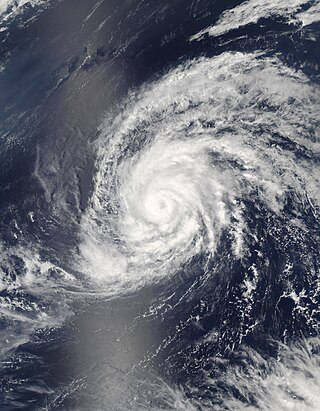
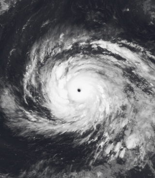
Typhoon Oliwa was one of a record eleven super typhoons in the 1997 Pacific typhoon season. Oliwa formed in the central Pacific Ocean on September 2 to the southwest of Hawaii, but it became a typhoon in the western Pacific. Oliwa explosively intensified on September 8, increasing its winds from 85 mph to 160 mph in a 24‑hour period. Afterward, it slowly weakened, and after passing east of Okinawa, Oliwa turned northeast and struck Japan with winds of 85 mph (137 km/h). There, it affected 30,000 people and killed 12; thousands of houses were flooded, and some were destroyed. Offshore South Korea, the winds and waves wrecked 28 boats, while one boat went missing with a crew of 10 people. Oliwa dissipated on September 19 in northern Pacific Ocean near the International Date Line.

Typhoon Roy, known in the Philippines as Typhoon Asiang, was the second-most intense January tropical cyclone on record in the Western Pacific basin. Forming out of an area of disturbed weather on January 7, 1988, Roy quickly intensified as it moved through the Marshall Islands. By January 9, the storm intensified into a typhoon and attained its peak intensity the following day. At its peak, sustained winds reached 215 km/h (135 mph). Slight weakening took place before the storm moved through the Mariana Islands. Continuing westward, the system eventually struck the Philippines as a minimal typhoon before dissipating over the South China Sea on January 19.
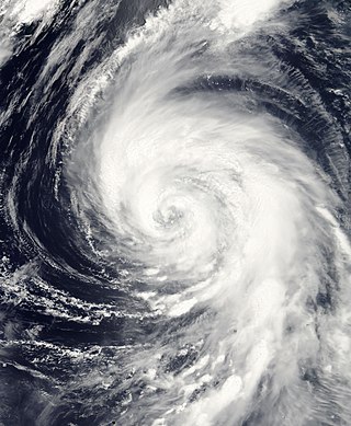
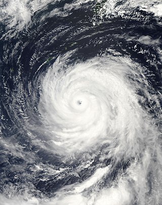
Typhoon Keith was an extremely powerful tropical cyclone and the tenth of a record eleven super typhoons to develop during the unusually intense 1997 Pacific typhoon season. Originating from a near-equatorial trough on October 26, the precursor depression to Keith slowly organized into a tropical storm. After two days of gradual strengthening, the storm underwent a period of rapid intensification on October 30 as winds increased to 195 km/h (121 mph). On November 1, the storm further intensified into a super typhoon and later attained peak winds of 285 km/h (177 mph). The following day, the powerful storm passed between Rota and Tinian in the Northern Mariana Islands. After fluctuating in strength over the following few days, a steady weakening trend established itself by November 5 as the typhoon accelerated towards the northeast. On October 8, Keith transitioned into an extratropical cyclone and was last noted early the following day near the International Dateline.

Typhoon Higos was, at that time, considered the third strongest typhoon to affect Tokyo since World War II. The 21st named storm of the 2002 Pacific typhoon season, Higos developed on September 25 east of the Northern Marianas Islands. It tracked west-northwestward for its first few days, steadily intensifying into a powerful typhoon by September 29. Higos subsequently weakened and turned to the north-northeast toward Japan, making landfall in that country's Kanagawa Prefecture on October 1. It weakened while crossing Honshu, and shortly after striking Hokkaidō, Higos became extratropical on October 2. The remnants passed over Sakhalin and dissipated on October 4.
Typhoon Songda, known in the Philippines as Typhoon Nina, was the sixth-costliest typhoon on record. The 18th named storm of the 2004 Pacific typhoon season, Songda developed on August 26 near the Marshall Islands. Following a path that Typhoon Chaba took nine days prior, Songda moved west-northwestward and strengthened quickly amid favorable conditions.

Typhoon Cimaron was a typhoon that caused minimal impacts in the Mariana Islands and Japan in August 2018. The twenty-third depression, twenty-first named storm, eleventh severe tropical storm, and seventh typhoon of the 2018 Pacific typhoon season, Cimaron developed from a tropical depression near the Marshall Islands on August 16. The depression soon became Tropical Storm Cimaron on August 18. Cimaron gradually intensified into a typhoon on August 21, and rapidly reached its peak intensity the next day. Cimaron then weakened before making two landfalls in Japan as a Category 1 typhoon on August 23. Cimaron continued to weaken until it became an extratropical cyclone and dissipated on August 24.

Typhoon Faxai was the strongest tropical cyclone worldwide in 2001. The twenty-fifth named storm and the sixteenth typhoon of the 2001 Pacific typhoon season, Faxai originated from a circulation in the monsoon trough. The system remained stationary for several days near Kosrae, pouring heavy rain that knocked down power. An indirect death occurred on the island as well. As the storm steadily intensified, Faxai moved west-northwestward at a very slow pace as it neared Pingelap, damaging crops, before bringing strong winds and rainfall that produced two landslides in Pohnpei on December 20. Intensity fluctuated, but convection in the core became more defined and by December 21, Faxai had intensified into a typhoon. A period of rapid intensification then followed, and by early December 23, Faxai reached its peak intensity.

