
The 1959 Pacific typhoon season was regarded as one of the most devastating years for Pacific typhoons on record, with China, Japan and South Korea sustaining catastrophic losses. It was an event in the annual cycle of tropical cyclone formation. The season had no official bounds, but tropical cyclones in the Western Pacific Ocean normally develop between May and October.
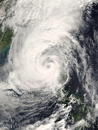
Typhoon Xangsane, known in the Philippines as Typhoon Reming, was a typhoon that made landfall in the Philippines and Taiwan. The 30th named storm and 12th typhoon of the 2000 Pacific typhoon season. Xangsane made landfall in southern Luzon in the Philippines, on October 27. The storm then turned north, heading northeastward over the South China Sea. On October 29, Xangsane reached its peak intensity, with 10-minute sustained winds of 140 km/h (87 mph), 1-minute sustained winds of 165 km/h (103 mph) and a minimum barometric pressure of 960 hPa (28 inHg). The storm paralleled the eastern coast of Taiwan, the next day. After leaving the vicinity of Taiwan, Xangsane started to weaken as it continued to move northeastward over the East China Sea and subsequently transitioned to an extratropical cyclone, midway between the eastern coast of China and the northern Okinawa Islands, on November 1. Xangsane was responsible for 187 casualties, including 83 possibly indirectly from the crash of Singapore Airlines Flight 006 on October 31, 2000.

The 2018 Pacific typhoon season was at the time, the costliest Pacific typhoon season on record, until the record was beaten by the following year. The season was well above-average, producing twenty-nine storms, thirteen typhoons, seven super typhoons and six Category 5 tropical cyclones. The season ran throughout 2018, though most tropical cyclones typically develop between May and October. The season's first named storm, Bolaven, developed on January 3, while the season's last named storm, Man-yi, dissipated on November 28. The season's first typhoon, Jelawat, reached typhoon status on March 29, and became the first super typhoon of the year on the next day.

Typhoon Ida, also known as the Kanogawa Typhoon, was the sixth-deadliest typhoon to hit Japan, as well as one of the strongest tropical cyclones on record. On September 20, Ida formed in the Western Pacific near Guam. It moved to the west and rapidly intensified into a 185 km/h (115 mph) typhoon by the next day. On September 22, Ida turned to the north and continued its quick rate of intensification. Two days later, the Hurricane Hunters observed a minimum barometric pressure of 877 mb (25.9 inHg), as well as estimated peak winds of 325 km/h (202 mph). This made Ida the strongest tropical cyclone on record at the time, although it was surpassed by Typhoon June 17 years later. Ida weakened as it continued to the north-northeast, and made landfall in Japan on southeastern Honshū with winds of 130 km/h (80 mph) on September 26. It became extratropical the next day, and dissipated on the September 28 to the east of the country. Ida caused torrential flooding to southeastern Japan, resulting in over 1,900 mudslides. Damage was estimated at $50 million, and there were 1,269 fatalities.
Typhoon Cora, also known as the 2nd Miyako-jima Typhoon in Japan, was a typhoon that hit the Ryūkyū Islands in 1966.

Typhoon Tokage, known in the Philippines as Typhoon Siony, was the deadliest typhoon to strike Japan since Typhoon Bess in 1982. The twenty-third storm to be named using an international list of names during the 2004 Pacific typhoon season, Tokage was the last of three typhoons to impact Japan from late-September to mid-October 2004. Typhoon Tokage began as a tropical depression near the Northern Mariana Islands on October 10. With very warm waters, the system started to undergo a rapid deepening phase early on October 13 and reached its peak strength on the 17th. Tokage made landfall over Japan on October 20, just before becoming extratropical.
Typhoon Phanfone, known in the Philippines as Typhoon Neneng, was a powerful tropical cyclone which affected Japan in early October 2014. It was the eighteenth named storm and the eighth typhoon of the 2014 Pacific typhoon season. Phanfone started as a large area of convection well west of the International Date Line. The system was well organized and classified as Tropical Depression 18W on September 29. At the same day, it gained the name Phanfone due to very favorable conditions and intense thunderstorms rich with convection surrounding the storm's center. Phanfone would later go rapid intensification on October 1 due to warm sea-surface temperatures and very favorable environments. JTWC upgraded Phanfone to a Category 4 typhoon but weakened later back to Category 3 due to its eye replacing the old one and undergoing a minor eyewall replacement cycle.

Typhoon Vongfong, known in the Philippines as Super Typhoon Ompong, was the most intense tropical cyclone worldwide in 2014, and struck Japan as a large tropical system. It also indirectly affected the Philippines and Taiwan. Vongfong was the nineteenth named storm and the ninth typhoon of the 2014 Pacific typhoon season. Estimates assess damage from Vongfong to have been over US$160 million, mainly for striking mainland Japan. At least 9 people were killed along the path of the typhoon in those countries.
Typhoon Malakas, known in the Philippines as Typhoon Gener, was a powerful tropical cyclone which affected Taiwan and Japan in mid September 2016. It was the sixteenth named storm and the sixth typhoon of the annual typhoon season in 2016. Malakas formed on September 11, just south of Guam. The system gradually organized and improved its outer bands, which prompted JTWC to give its identifier as Tropical Depression 18W. A few hours later, JMA received its name Malakas for 18W. On September 13, Malakas entered the Philippine Area of Responsibility, which gained the name Gener by PAGASA. Despite its marginal conditions for further development, Malakas continued to intensify into a typhoon.

Typhoon Jongdari was a strong, long-lived and erratic tropical cyclone that impacted Japan and East China in late July and early August 2018. Formed as the twelfth named storm of the 2018 typhoon season near Okinotorishima on July 24, Jongdari gradually intensified and developed into the fourth typhoon of the year on July 26. Influenced by an upper-level low and a subtropical ridge, Jongdari executed a rare counter-clockwise southeast of Japan on the next day. At that time, it also reached peak intensity. The typhoon made landfall in Kii Peninsula, over Mie Prefecture of Japan locally early on July 29.

Typhoon Faxai, known in Japan as Reiwa 1 Bōsō Peninsula Typhoon, was the first typhoon to strike the Kantō region since Mindulle in 2016, and the strongest typhoon to hit the region since Ma-on in 2004. It was also the worst to hit the region since Talas in 2011, until the region was hit by more destructive Typhoon Hagibis less than a month later. Forming as the fifteenth named storm of the 2019 Pacific typhoon season, the precursor to Faxai was first noted as a weak tropical depression to the east of the International Dateline on August 29. The depression then entered the West Pacific basin on August 30. After moving in a general westward direction, the system strengthened into a named tropical storm by September 5. Faxai then strengthened into the sixth typhoon of the season the next day. Two days later, Faxai reached its peak strength as a Category 4 typhoon just before making landfall in mainland Japan. Turning northeastward, Faxai rapidly weakened and became extratropical on September 10.

Typhoon Georgia was one of the more impactful typhoons that struck Japan, as well as one of the few observed tropical cyclones that made direct landfall in Russia as a tropical storm. A low pressure system formed in the vicinity of Guam on August 10 which formed Tropical Depression Fran, and a new low-level center formed from a fracture of a trough that split newly formed tropical depression in the midnight of August 12. The newly formed low level center was classified as a tropical storm and was named Georgia hours later by the Joint Typhoon Warning Center. The new tropical storm was tracked by Japan Meteorological Agency shortly afterwards and Georgia rapidly intensified into a typhoon. On the next day, Georgia further intensified after passing Chichi Jima and reached peak sustained winds of 110 knots (57 m/s) while quickly accelerating in the north-northwest direction before striking Chūbu region in Japan on evening of the same day as a weakening typhoon. After emerging on the Sea of Japan as a tropical storm on August 14, Georgia made landfall in Soviet Union as a tropical storm at the afternoon of the same day, before transforming into an extratropical storm quickly after landfall. Remnants of Georgia was last noted on Heilongjiang, China on August 16.

Typhoon Cimaron was a typhoon that caused minimal impacts in the Mariana Islands and Japan in August 2018. The twenty-third depression, twenty-first named storm, eleventh severe tropical storm, and seventh typhoon of the 2018 Pacific typhoon season, Cimaron developed from a tropical depression near the Marshall Islands on August 16. The depression soon became Tropical Storm Cimaron on August 18. Cimaron gradually intensified into a typhoon on August 21, and rapidly reached its peak intensity the next day. Cimaron then weakened before making two landfalls in Japan as a Category 1 typhoon on August 23. Cimaron continued to weaken until it became an extratropical cyclone and dissipated on August 24.

Typhoon Talim, known in the Philippines as Typhoon Lannie, was an intense and destructive tropical cyclone that affected parts of East Asia, especially Japan, during September 2017. The eighteenth named storm and the sixth typhoon of the 2017 Pacific typhoon season, Talim's origins can be traced back to an area of low-pressure that the Joint Typhoon Warning Center first monitored on September 6. The disturbance was upgraded to a tropical depression by the Japan Meteorological Agency only two days later, and it became a tropical storm on September 9, earning the name Talim. Talim grew stronger over the next few days, eventually becoming a typhoon the next day. Within a favorable environment, the typhoon rapidly intensified after passing through the Ryukyu Islands. However, as it moved eastward, Talim started to weaken due to wind shear, and on September 16, it was downgraded to a tropical storm. The storm passed over Japan, near Kyushu the next day, before becoming extratropical on September 18. The extratropical remnants were last noted by the JMA four days later, before dissipating fully on September 22.

Typhoon Jane was a catastrophic and deadly tropical cyclone that left significant effects to Japan during the 1950 Pacific typhoon season. It caused over 398 reported deaths and 141 to be missing, mainly due to the landslides and flooding. It also destroyed some battle and cargo ships. The sixth reported typhoon of the season, Jane was first mentioned in weather maps as a tropical depression to the east of the Philippines. It quickly strengthened to a tropical storm as it moved to the northwest. It then curved to the northeast, reaching its peak intensity of 185 km/h before weakening and striking Minami in Tokushima Prefecture on September 3 as a Category 2 typhoon. It quickly weakened, passing through the Awaji Island and Kobe before becoming extratropical in the Sea of Japan on the same day. The extratropical remnants of the system persisted until it was no longer tracked on September 7.

Typhoon Dinah was a tropical cyclone that brought heavy damages to Japan, while leaving 65 fatalities and 70 to be missing, all in that country alone. It is also one of the disasters that happened in the country during the Showa 27 era. The second typhoon of the 1952 Pacific typhoon season, Dinah was first mentioned in weather maps as a tropical depression to the east of Visayas. It gradually organized, becoming a tropical storm on June 21 as it skirted the northeastern Philippines, with the Fleet Weather Center naming it Dinah. It strengthened further to a minimal typhoon as it moved through the Nansei Islands on June 22, before reaching its peak intensity of 140 km/h, as estimated by the Fleet Center. It then weakened shortly, before passing near Shikoku on the next day, then making landfall through the southern part of the Kii Peninsula before gradually weakened further and started to undergo extratropical transition as it moved out of the country on June 24. It then became fully extratropical on the next day.

Typhoon Louise, known in Japan as the Akune Typhoon, was a deadly and destructive tropical cyclone that hit Japan in October 1945, soon after the cessation of World War II. It caused at least 377 deaths and another 74 missing persons, while leaving a wide swath of damage across the country.

Typhoon Gilda, known in the Philippines as Typhoon Deling was a destructive, deadly, costly and long-lived tropical cyclone that left over 145 confirmed deaths over Japan and South Korea, mostly due to torrential rainfall that induced landslides, all generated by the typhoon and its associated meiyu front. The eighth named storm and third typhoon of the 1974 Pacific typhoon season, the system was first noted by the China Meteorological Agency as an area of convection embedded on a trough, to the north of Enewetak Atoll on June 25. It was named Gilda on June 30 as it strengthened to a tropical storm. Under a favorable environment, it strengthened to a typhoon two days later as it moved northwestward. Another trough pulled Gilda poleward while changing less in intensity, until it intensified to a Category 2 typhoon as it battered the Ryukyu Islands at its peak. Increasing wind shear gradually weakened the system; however, it remained as a minimal typhoon until it passed through the southern tip of South Korea on July 6, where it weakened to a tropical storm. Colder waters in the Sea of Japan and high shear further degraded Gilda, until it transitioned to an extratropical low as it made landfall near Hokkaido on July 9. The remnants of the system briefly intensified near the Kuril Islands before weakening and dissipating on July 17 over the Sea of Okhotsk.

Typhoon Olive was an erratic and slightly long-lived tropical cyclone that impacted Japan and affected Manchuria during early-August 1971. It severely disrupted the 13th World Scout Jamboree, which was being held in Fujinomiya, Shizuoka Prefecture. The twentieth depression, nineteenth named storm, and twelfth typhoon of the 1971 Pacific typhoon season, the system was first noted as an area of circulation in a near-equatorial trough, located to the east of Guam on July 24. After moving through the area, the system took a northward direction due to the influence of a trough. It then commenced a northeast move before organizing, though it didn't strengthen to a tropical depression until July 29. Slow but gradual intensification occurred, becoming a tropical storm in the early hours of July 31 as it moved to the west, before taking a north-northwest track as it intensified to a typhoon on August 2 while approaching the Ryukyu Islands. On the next day, it reached its peak intensity of 155 km/h (95 mph) and an unusually low barometric pressure of 935 mbar, equivalent to a mid-level typhoon as it started to batter the third-largest island of Japan, Kyushu. It then moved to the north, while weakening back to a minimal typhoon before making landfall on the area, with the records pointing it to the east of Nagasaki on August 5. It rapidly weakened while traversing Kyushu, before entering the Sea of Japan. At this time, it passed near the southern part of Korea before curving to the northeast. It then passed near Russian Manchuria before weakening below gale-force, shortly before becoming extratropical as it passed through the La Pérouse Strait on August 9. It then accelerated through the Pacific Ocean before dissipating on the next day.
Typhoon June was a large, strong and devastating typhoon that severely impacted the west and central areas of mainland Japan, causing scores of deaths and heavy devastation. A large storm, it was the tenth storm to be tracked by the Fleet Weather Center (FWC) during the 1954 Pacific typhoon season. The storm was already a tropical storm when it was first noticed by both the FWC and JMA by September 4. Only six hours later, the storm intensified into a typhoon and underwent rapid intensification into a modern-day Category 4 super typhoon just east of northern Luzon in the Philippines with maximum sustained winds of 130 knots calculated in 1-minute sustained winds along with JMA's estimates of its minimum pressure of 910 millibars (27 inHg) on September 7. However, it started to weaken below super typhoon status, and its intensity began to fluctuate while moving northwestwards and north-northwestwards. As it turned northwards by September 12, June regained its intensity as a Category 4 system before making landfall over Yamaguchi Prefecture's Shimonoseki City. There, it weakened and crossed into the Sea of Japan as a tropical storm. Data from the now-Joint Typhoon Warning Center indicated that as the storm made landfall somewhere Primorsky Krai, it retained its tropical storm status. Upon moving inland, it degenerated into an extratropical low before being last monitored by FWC during September 15. However, the JMA did the same on the next day at 06:00 UTC.

