Typhoon Opal (1962)

Last updated

Map key
  Tropical depression (≤38 mph, ≤62 km/h)
  Tropical storm (39–73 mph, 63–118 km/h)
  Category 1 (74–95 mph, 119–153 km/h)
  Category 2 (96–110 mph, 154–177 km/h)
  Category 3 (111–129 mph, 178–208 km/h)
  Category 4 (130–156 mph, 209–251 km/h)
  Category 5 (≥157 mph, ≥252 km/h)
  Unknown
Storm type
Disc Plain black.svg Tropical cyclone
Solid black.svg Subtropical cyclone
ArrowUp.svg Extratropical cyclone, remnant low, tropical disturbance, or monsoon depression

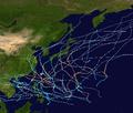
An easterly wave met with a polar trough just northwest of the island of Ponape. on the afternoon of July 28. The Joint Typhoon Warning Center (JTWC) began following the wave for the next day, as it headed westward, north of Truk. Slowly curving northeast from the island, the wave soon was upgraded to a tropical depression with winds of 30 mph (48 km/h) with no eye structure on July 30. The depression strengthened on the morning of July 31 to 35 mph (56 km/h) winds and persisted throughout the day at that strength. The depression continued its northwestern curve, speeding up and weakening once again to 30 mph (48 km/h) on the morning of August 1. [1] After passing Woleai, the depression strengthened once again and became Tropical Storm Opal the same afternoon. The storm continued intensifying during the afternoon, with winds reaching 50 mph (80 km/h) by nightfall. By the next morning, Opal was upgraded into a typhoon, the eighth of the 1962 season. [2] The typhoon, now northwest of the island of Ulithi, continued turning to the northwest, beginning to slow as the system continued strengthening. By nightfall, the system had an eye forming, wide as 5 miles (8.0 km). By nightfall, the system was up to winds of 90 mph (140 km/h) and passing far east of the Philippines. Opal continued the northwest progression, strengthening throughout the day of August 3 and forming a wider eye. By the end of the day, the storm was now a Category 3 typhoon with winds of 115 mph (185 km/h). Strengthening continued overnight as the typhoon passed to the east of Luzon, strengthening close to super typhoon status by nightfall on August 4 with a shrinking eye. The next morning, Typhoon Opal strengthened into the second super typhoon of the season, boasting sustained winds of 160 mph (260 km/h). During the day on August 5, Opal continued strengthening, peaking with winds of 165 mph (266 km/h) just east of Taiwan. [2] (Operationally, Opal was classified as a 170 mph (270 km/h) typhoon, but this was downgraded to a 165 mph (266 km/h) in post-analysis.) Minimum recorded central pressures for Opal were registered at 900 millibars. [3] Soon after peaking, the storm struck the island of Taiwan with winds of 165 mph (266 km/h). The storm weakened over land to 135 mph (217 km/h) after crossing the island and continued weakening into a 90 mph (140 km/h) typhoon as it made landfall in mainland China. The typhoon continued to weaken over land, weakening into a tropical storm on the morning of August 6. Opal persisted as a tropical storm on August 6, weakening into a tropical depression the next morning. During the afternoon of August 7, with influences from land, the storm became extratropical. [4] [2] The extratropical remains of Opal crossed eastern mainland China, entering the East China Sea in the late evening. Early in the morning of August 8, the storm struck North Korea near the capital city of Pyongyang. After crossing the country, the system reappeared in the sea before crossing. On the morning of August 9, the system made landfall on the Hokkaido region of Japan, near the town of Rumoi. After crossing the island, the storm entered the Sea of Okhotsk on August 10. During the afternoon, the system crossed the Kuril Islands and began a parallel with the Kamchatka Peninsula the next day. On the morning of August 13, the system entered the Aleutian Islands, passing west of Semisopochnoi Island and the Rat Islands before entering the Bering Sea. The extratropical remains disappeared on August 14 in the middle of the sea, just south of the Arctic Circle. [5]

Impact

The impact of Typhoon Opal was most devastating in Taiwan, where originally 87 deaths were reported on the island, with 20 people missing and over 1400 injured. Some 5,000 people were homeless in Yilan City. [6] Nearly 1,500 homes were destroyed as a result of Opal, along with 4,700 others damaged due to the high winds. Huge waves kicked up by Opel also sent a storm surge into the city, sweeping away homes. [7] However, by August 8, this number was demoted to only 12 deaths on the island, 966 injured and five people missing. [8] The 170 mph (270 km/h) strong winds took a freighter off its anchors and swamping it, along with a number of fishing boats. [6] Although winds of 110 mph (180 km/h) were felt in Taipei, no fatalities were reported because of ample warning, causing residents to evacuate. [7] [9] In Taipei, Opal caused streets to flood, uprooted trees and tore down telephone lines. [9] 38 injuries were also reported, with 35 houses destroyed. 180 were also damaged in Taipei. [10] Elsewhere, Opal caused two deaths in the islands of Japan, centered on the island of Southern Hokkaido. [11] Nine people there were also injured and one person was reported missing. [12] After Typhoon Opal passed through South Korea, seven fishermen were killed along the coast of the Yellow Sea. 72 more people were missing. Five ships were also sunk in the Yellow Sea, twelve more were reported missing. [13] The estimated damage total came out to about $25 million (1962 USD; $184 million (2011 USD)). These totals came in the form of crop, transportation, and structural damage. [14]

See also

Related Research Articles

<span class="mw-page-title-main">2005 Pacific typhoon season</span> Typhoon season in the Western Pacific Ocean

The 2005 Pacific typhoon season was the least active typhoon season since 2000, producing 23 named storms, of which 13 became typhoons. It was an event in the annual cycle of tropical cyclone formation, in which tropical cyclones form in the western Pacific Ocean. The season ran throughout 2005, though most tropical cyclones typically develop between May and October. The season's first named storm, Kulap, developed on January 13, while the season's last named storm, Bolaven, dissipated on November 20. The season's first typhoon, Haitang, reached typhoon status on July 13, and became the first super typhoon of the year three days later.

<span class="mw-page-title-main">2004 Pacific typhoon season</span> Typhoon season in the Western Pacific Ocean

The 2004 Pacific typhoon season was an extremely active season that featured the second-highest ACE ever recorded in a single season, second only to 1997, which featured 29 named storms, nineteen typhoons, and six super typhoons. It was an event in the annual cycle of tropical cyclone formation, in which tropical cyclones form in the western Pacific Ocean. The season ran throughout 2004, though most tropical cyclones typically develop between May and October. The season's first named storm and also the first typhoon, Sudal, developed on April 4, later was reached typhoon status two days later, and became the first super typhoon of the year three days later. The season's last named storm, Noru, dissipated on December 21.

<span class="mw-page-title-main">2001 Pacific typhoon season</span> Typhoon season in the Western Pacific Ocean

The 2001 Pacific typhoon season was the fourth and final consecutive year with below-average activity, mainly due to the presence of a strong La Niña that had persisted from 1998 to 2001. However, it was more active than the previous seasons, producing twenty-five named storms, sixteen typhoons and three super typhoons, with a near normal Accumulated Cyclone Energy (ACE) of 307.3 units. It ran year-round in 2001, with most tropical cyclones in the northwestern Pacific Ocean tending between May and November.

<span class="mw-page-title-main">2000 Pacific typhoon season</span> Typhoon season in the Western Pacific Ocean

The 2000 Pacific typhoon season marked the first year using names contributed by the World Meteorological Organization. It was a rather below-average season, producing a total of 23 tropical storms, 13 typhoons and 4 intense typhoons. The season ran throughout 2000, though typically most tropical cyclones develop between May and October. The season's first named storm, Damrey, developed on May 7, while the season's last named storm, Soulik, dissipated on January 4 of the next year.

<span class="mw-page-title-main">1999 Pacific typhoon season</span> Typhoon season in the Western Pacific Ocean

The 1999 Pacific typhoon season was the last Pacific typhoon season to use English names as storm names. It also featured the lowest number of typhoons on record, with only five reaching this intensity. This was mainly due to a strong La Niña which persisted from last year. The season was also below-average in named storms, with only 20 of such spawning. It had no official bounds; it ran year-round in 1999, but most tropical cyclones tend to form in the northwestern Pacific Ocean between May and November. These dates conventionally delimit the period of each year when most tropical cyclones form in the northwestern Pacific Ocean. The first named storm, Hilda, developed on January 6, while the last named storm, Gloria, dissipated on November 16.

<span class="mw-page-title-main">1991 Pacific typhoon season</span> Typhoon season in the Pacific Ocean

The 1991 Pacific typhoon season was a slightly above-average season with 29 tropical storms, 17 typhoons and five super typhoons forming. It was quite a catastrophic season – Typhoon Yunya impacted the Philippines in mid June while in the same time experiencing a volcanic eruption, Typhoon Mireille severely impacting Japan, which became known for being the costliest typhoon on record with US$10 billion worths of damages, and Tropical Storm Thelma on November which became one of the deadliest storms to strike the Philippines, killing at least over 5,000 people.

<span class="mw-page-title-main">1985 Pacific typhoon season</span> Typhoon season in the Pacific Ocean

The 1985 Pacific typhoon season was a slightly above average season in terms of named storms, though most storms were weak and short-lived. The season had 28 named storms, 15 typhoons and 1 super typhoon. It ran year-round, thus ending the two-season run which began in 1983 that only had tropical cyclones forming between June and December. These dates conventionally delimit the period of each year when most tropical cyclones form in the northwestern Pacific Ocean. A total of 57 tropical depressions formed this year, of which only 28 became tropical storms and were assigned a name by the Joint Typhoon Warning Center. This made the season well above average. Additionally, tropical depressions that enter or form in the Philippine area of responsibility were assigned a name by the Philippine Atmospheric, Geophysical and Astronomical Services Administration or PAGASA. This can often result in the same storm having two names. This year, a total of 17 storms were named this way.

<span class="mw-page-title-main">1984 Pacific typhoon season</span> Typhoon season in the Pacific Ocean

The 1984 Pacific typhoon season had the second-latest start in the basin on record, only behind the previous year by one day. Despite this, it was above average in terms of named storms and featured many intense storms. It ran year-round in 1984, but again all tropical cyclones formed between June and December. These dates conventionally delimit the period of each year when most tropical cyclones form in the northwestern Pacific Ocean. A total of 44 tropical depressions formed this year, of which only 27 became tropical storms and were assigned a name by the Joint Typhoon Warning Center. This made the season above average when compared to the long term mean of 25 storms per season. Additionally, tropical depressions that enter or form in the Philippine area of responsibility are assigned a name by the Philippine Atmospheric, Geophysical and Astronomical Services Administration or PAGASA. This can often result in the same storm having two names. This year, a total of 20 storms were named this way.

<span class="mw-page-title-main">1982 Pacific typhoon season</span> 1982 typhoon season in the Pacific Ocean

The 1982 Pacific typhoon season was an average season in terms of total tropical storms, though it featured a very high amount of typhoons. It ran year-round in 1982, but most tropical cyclones formed between June and December. These dates conventionally delimit the period of each year when most tropical cyclones form in the northwestern Pacific Ocean. A total of 37 tropical depressions formed this year, of which 25 became tropical storms and were assigned a name by the Joint Typhoon Warning Center. Additionally, tropical depressions that enter or form in the Philippine area of responsibility are assigned a name by the Philippine Atmospheric, Geophysical and Astronomical Services Administration or PAGASA. This can often result in the same storm having two names. This year, a total of 23 storms were named this way.

<span class="mw-page-title-main">1980 Pacific typhoon season</span> Period of formation of tropical cyclones in the Western Pacific Ocean in 1980

The 1980 Pacific typhoon season was a slightly-below average season when compared to the long-term average, though it featured several intense storms. It ran year-round in 1980, but most tropical cyclones formed between June and December. These dates conventionally delimit the period of each year when most tropical cyclones form in the northwestern Pacific Ocean. A total of 28 tropical depressions formed this year in the Western Pacific, of which 24 became tropical storms and were assigned a name by the Joint Typhoon Warning Center. Beginning in March, tropical cyclones formed in each subsequent month through December. Of the 24 named storms, 15 storms reached typhoon intensity, of which 2 reached super typhoon strength.

<span class="mw-page-title-main">1976 Pacific typhoon season</span>

The 1976 Pacific typhoon season has no official bounds; it ran year-round in 1976, but most tropical cyclones tend to form in the northwestern Pacific Ocean between June and December. These dates conventionally delimit the period of each year when most tropical cyclones form in the northwestern Pacific Ocean.

<span class="mw-page-title-main">1970 Pacific typhoon season</span> Typhoon season in the Pacific Ocean

The 1970 Pacific typhoon season has no official bounds; it ran year-round in 1970, but most tropical cyclones tend to form in the northwestern Pacific Ocean between June and December. These dates conventionally delimit the period of each year when most tropical cyclones form in the northwestern Pacific Ocean.

<span class="mw-page-title-main">1971 Pacific typhoon season</span> Typhoon season in the Pacific Ocean

The 1971 Pacific typhoon season was an extremely active season that featured the second highest typhoon count on record. It has no official bounds; it ran year-round in 1971, but most tropical cyclones tend to form in the northwestern Pacific Ocean between June and December. These dates conventionally delimit the period of each year when most tropical cyclones form in the northwestern Pacific Ocean.

<span class="mw-page-title-main">1964 Pacific typhoon season</span> Typhoon season in the Pacific Ocean

The 1964 Pacific typhoon season was the most active tropical cyclone season recorded globally, with a total of 39 tropical storms forming. It had no official bounds; it ran year-round in 1964, but most tropical cyclones tend to form in the northwestern Pacific Ocean between June and December. These dates conventionally delimit the period of each year when most tropical cyclones form in the northwestern Pacific Ocean.

<span class="mw-page-title-main">1962 Pacific typhoon season</span> Typhoon season in the Pacific Ocean

The 1962 Pacific typhoon season had no official bounds; there was activity in every month but January, March, and June, but most tropical cyclones form in the northwestern Pacific Ocean between May and November and this conventionally delimits the season.

<span class="mw-page-title-main">Typhoon Amy (1962)</span> Pacific typhoon in 1962

Typhoon Amy was a super typhoon formed in August and September 1962. Amy made landfall in Taiwan as a category 4 equivalent super typhoon, then in China as a typhoon, moved out into the South China Sea, and finally made landfall in South Korea as a tropical storm.

<span class="mw-page-title-main">Typhoon Charlotte (1959)</span> Pacific typhoon in 1959

Typhoon Charlotte was a damaging typhoon that struck Okinawa during the 1959 Pacific typhoon season. An area of low pressure developed in early October, and it became a tropical depression on October 9. The depression strengthened to a tropical storm one day later, and it received the name Charlotte from the Joint Typhoon Warning Center (JTWC). The system strengthened quickly and became a typhoon eighteen hours later. Charlotte continued to rapidly strengthen to its peak of 260 km/h (160 mph) on October 13. The typhoon began to weaken afterwards, and it traveled south of Okinawa on October 16. The typhoon weakened to a tropical storm on October 19 as it began its extratropical transition. The storm became extratropical later that day, and the Japan Meteorological Agency (JMA) ceased tracking the system on October 20.

<span class="mw-page-title-main">Typhoon Kong-rey (2018)</span> Pacific typhoon in 2018

Typhoon Kong-rey, known in the Philippines as Super Typhoon Queenie, was a large and powerful typhoon that was tied with Typhoon Yutu as the most powerful tropical cyclone worldwide in 2018. The twenty-fifth tropical storm, eleventh typhoon and 6th super typhoon of the 2018 Pacific typhoon season, Kong-rey originated from a tropical disturbance in the open Pacific. For a couple days, it went westward, organizing into a tropical depression on September 27. Then it intensified into a powerful Category 5 super typhoon early on October 2. Kong-rey underwent an eyewall replacement cycle after its peak intensity, causing it to weaken into a Category 3 typhoon under unfavorable conditions. Kong-rey then struck South Korea on October 6 as a tropical storm. Kong-rey transitioned into an extratropical cyclone later that day while impacting Japan.

<span class="mw-page-title-main">Typhoon Maysak (2020)</span> Pacific typhoon in 2020

Typhoon Maysak, known in the Philippines as Typhoon Julian, was a deadly, damaging and powerful tropical cyclone that struck the Ryukyu Islands and the Korean Peninsula in September 2020. The third typhoon of the 2020 Pacific typhoon season, Maysak formed from a tropical disturbance. The disturbance gradually organized, receiving the name Julian from PAGASA as it became a tropical depression. As the depression strengthened, the JMA subsequently named the system Maysak. Maysak rapidly intensified into a strong typhoon before weakening and making landfall in South Korea.

<span class="mw-page-title-main">Typhoon Surigae</span> Pacific typhoon in 2021

Typhoon Surigae, known in the Philippines as Super Typhoon Bising, was the strongest Northern Hemisphere tropical cyclone to form before the month of May, one of the most intense tropical cyclones on record and the strongest tropical cyclone worldwide in 2021. The second named storm, first typhoon and first super typhoon of the 2021 Pacific typhoon season, Surigae originated from a low-pressure area south of the Micronesian island of Woleai that organized into a tropical depression on April 12. At 18:00 UTC that day, it strengthened to a tropical storm and was named Surigae by the Japan Meteorological Agency (JMA). The formation of an eye and increasing winds prompted the JMA to upgrade the system to a severe tropical storm on April 13. The storm continued to gradually strengthen, and late on April 15, Surigae became a typhoon. Very favorable environmental conditions then allowed Surigae to begin a bout of rapid intensification; Surigae became a super typhoon the next day, and by April 17, the storm reached its peak intensity, with 10-minute sustained winds of 220 km/h (140 mph), 1-minute sustained winds of 315 km/h (196 mph), and a minimum pressure of 895 hPa (26.4 inHg). This made it the strongest pre-May typhoon on record. Afterward, the storm's weakening outflow and an eyewall replacement cycle caused Surigae to gradually weaken as its track shifted north-northwestward in the Philippine Sea. Following the eyewall replacement cycle, Surigae became an annular tropical cyclone on April 19, and restrengthened slightly. On April 22, the storm began to rapidly weaken as it accelerated northwestward into unfavorable environmental conditions, transitioning into a subtropical storm the next day. The subtropical system subsequently underwent extratropical transition, which it completed by April 24. Afterward, Surigae's extratropical remnant accelerated northeastward. On April 27, Surigae's remnant explosively intensified into a bomb cyclone near the Aleutian Islands, attaining hurricane-force winds. Afterward, the system gradually weakened as it turned eastward, slowing down in the process, before crossing the International Date Line on April 30 and fully dissipating on May 2.

References

  1. "Annual Tropical Cyclone Report – 1962" (PDF). Pearl Harbor, Hawaii: Joint Typhoon Warning Center. 1962. Retrieved November 30, 2008.
  2. 1 2 3 "Best Track – Typhoon Opal". Pearl Harbor, Hawaii: Joint Typhoon Warning Center. 2011. Retrieved August 16, 2011.
  3. "Annual Tropical Cyclone Report – 1962" (PDF). Pearl Harbor, Hawaii: Joint Typhoon Warning Center. 1962. Retrieved November 30, 2008.
  4. "Annual Tropical Cyclone Report – 1962" (PDF). Pearl Harbor, Hawaii: Joint Typhoon Warning Center. 1962. Retrieved November 30, 2008.
  5. "RSMC Best Track Data (Graphics) in 1962". Tokyo, Japan: Japan Meteorological Agency. 1962. Archived from the original on May 23, 2011. Retrieved April 27, 2011.
  6. 1 2 "Typhoon Kills 87 Formosans". The Age. August 7, 1962. Retrieved May 16, 2011.
  7. 1 2 "87 Dead In Typhoon At Town In Taiwan". The New York Times. August 6, 1962.
  8. "Estimate of Typhoon Toll Scaled Down". Lewiston Morning Tribune. August 8, 1962. Retrieved May 16, 2011.
  9. 1 2 "Formosa Is Lashed By 170 Mile Winds". The Lewiston Daily Sun. Lewiston, Maine. August 6, 1962. p. 1. Retrieved May 16, 2011.
  10. "Typhoon Opal Slams Across Formosa". The Bonham Daily Favorite. Bonham, Texas. August 6, 1962. p. 1. Retrieved May 16, 2011.
  11. "昭和37年台風第10号による大雨 | ほっかいどうの防災教育". kyouiku.bousai-hokkaido.jp (in Japanese). Retrieved August 9, 2020.
  12. "150 Killed or Missing in Typhoon". The Youngstown Vindicator. August 10, 1962. Retrieved May 16, 2011.
  13. "Storm Claims 7". Spokane Daily Chronicle. August 15, 1962. Retrieved May 16, 2011.
  14. "Annual Tropical Cyclone Report – 1962" (PDF). Pearl Harbor, Hawaii: Joint Typhoon Warning Center. 1962. Retrieved November 30, 2008.
Typhoon Opal
Typhoon Opal TIROS V 24 aug 1962 0810Z.jpg
Typhoon Opal on August 4