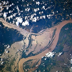
The Uatuma-Trombetas moist forests (NT0173) is an ecoregion in northwest Brazil in the Amazon biome. It covers the Amazon basin north of the Amazon River from close to the Atlantic Ocean to the Rio Negro west of Manaus. The ecoregion is relatively intact, although it has been damaged along the main rivers and around population centers.
The Uatuma-Trombetas moist forests ecoregion is in the north of Brazil in parts of the states of Roraima, Amazonas and Amapá to the north of the Amazon River. Small areas of the ecoregion cross the Brazilian border into Guyana and Suriname. It has an area of 47,319,082 hectares (116,928,000 acres).[1] The ecoregion covers the area to the north of the Amazon River from close to the Atlantic coast to the Rio Negro and the Branco River. In the north to extends to the mountains along the border between Brazil and the Guianas and Suriname. On the 1993 Brazilian Institute of Geography and Statistics map the Brazilian part is shown as "lowland ombrophilous dense forests", "submontane ombrophilous dense forests" and "ombrophilous forest – savanna transition".[2]
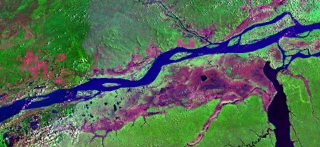
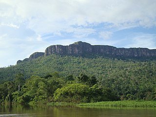
The north of the ecoregion reaches into the quartzite or sandstone upland terraces and mountains of the ancient Guiana Shield, while the south is in the much newer sedimentary basin of the Amazon River, formed during the recent Tertiary period. It contains high plains, rolling hills and lowlands, with diverse fauna and flora in the different habitats. Soils are mostly kaolinite, or sandy podzols on the slopes, and are low in nutrients, but some areas have very fertile clay loam soils. The ecoregion is crossed by various blackwater or clearwater rivers, including the Trombetas, Jari, Uatumã, Curuapanema, Paru and Araguari.[2]
Climate
The Köppen climate classification is "Am": equatorial, monsoonal.[4] Mean monthly temperatures are 26 to 27°C (79 to 81°F). Rainfall is seasonal. Average annual rainfall ranges from 1,700 millimetres (67in) in the east to 3,000 millimetres (120in) in the west.[2]
The ecoregion contains lowland flooded forests along tributaries of the Amazon, and seasonally dry forests and meadows on the Guiana Shield.[1] The larger part of the ecoregion is covered by humid rainforest with a canopy 30 to 40 metres (98 to 131ft) high and emergent trees reaching 50 metres (160ft). There are areas of seasonal forest east of Óbidos that is dry in the summer and has a canopy under 20 metres (66ft), with mesophyllous, semidecidous and xeromorphic flora. There are also some open meadows.[2]
482 species of birds have been reported including tinamous (genus Crypturellus), parrots (genus Amazona), macaws (genus Ara), cookoos (genus Coccyzus), potoos (family Nyctibiidae) and tanagers (genus Tachyphonus).[2] Endangered birds include the sun parakeet (Aratinga solstitialis).[5]
Status
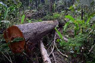
The World Wildlife Fund classes the ecoregion as "Relatively Stable/Intact".[2] The habitat is fairly intact in the interior, but continues to suffer from deforestation along the main roads and rivers, around and to the north of Manaus, and in the region from Óbidos to Monte Alegre along the Amazon. Cattle ranchers have cleared large areas of forest, as have commercial plantations around the Jari River and forestry in the east of the region. Some species are threatened by the trade in wildlife, by hunting and by selective logging. Upland areas have been destroyed by mining, which has polluted the rivers. Huge areas of upland forest were submerged by the Balbina Dam in the southwest.[2]
WildFinder, WWF: World Wildlife Fund, retrieved 2017-03-25
Related Research Articles
Campinarana, also called Rio Negro Campinarana, is a neotropical ecoregion in the Amazon biome of the north west of Brazil and the east of Colombia that contains vegetation adapted to extremely poor soil. It includes savanna, scrub and forest, and contains many endemic species of fauna and flora.
The Caquetá moist forests (NT0107) is an ecoregion of tropical moist broad leaf forest to the east of the Andes in the east of Colombia, with a small section in Brazil, in the Amazon biome. The forests are in the transition between the Guiana and Amazon regions, and have highly diverse flora and fauna. They are relatively intact, although they are mostly unprotected and are threatened with deforestation to create cattle pastures.
The Guianan savanna (NT0707) is an ecoregion in the south of Venezuela, Guyana and Suriname and the north of Brazil. It is in the Amazon biome. The savanna covers an area of rolling upland plains on the Guiana Shield between the Amazon and Orinoco basins. It includes forested areas, but these are shrinking steadily due to the effect of frequent fires, either accidental or deliberate. The ecoregion includes the Gran Sabana region of Venezuela.
The Negro-Branco moist forests (NT0143) is an ecoregion of tropical moist broadleaf forest to the east of the Andes in southern Venezuela, eastern Colombia and northern Brazil, in the Amazon biome. It lies on the watershed between the Orinoco and Rio Negro basins. It includes both blackwater and whitewater rivers, creating different types of seasonally flooded forest. The vegetation is more typical of the Guiana region than the Amazon.
The Japurá-Solimões-Negro moist forests (NT0132) is an ecoregion of tropical moist broad leaf forest in the Amazon biome.
The Marajó várzea (NT0138) is an ecoregion of seasonally and tidally flooded várzea forest in the Amazon biome. It covers a region of sedimentary islands and floodplains at the mouth of the Amazon that is flooded twice daily as the ocean tides push the river waters onto the land. The flooded forests provide food for a wide variety of fruit-eating fish, aquatic mammals, birds and other fauna. It has no protected areas and is threatened by cattle and water-buffalo ranching, logging and fruit plantations.
The Gurupa várzea (NT0126) is an ecoregion of seasonally and tidally flooded várzea forest along the Amazon River in the Amazon biome.
The Monte Alegre várzea (NT0141) is an ecoregion of seasonally flooded várzea forest along the Amazon River in the Amazon biome.
The Purus várzea (NT0156) is an ecoregion of seasonally flooded várzea forest in the central Amazon basin. It is part of the Amazon biome. The ecoregion is home to a vegetation adapted to floods of up to 12 metres (39 ft) that may last for eight months. There is a great variety of fish and birds, but relatively fewer mammals. Ground-dwelling mammals must migrate to higher ground during the flood season. Threats include logging, cattle farming, over-fishing and mercury pollution from gold mining.
The Purus-Madeira moist forests (NT0157) is an ecoregion in the central Amazon basin. It is part of the Amazon biome. The ecoregion covers a stretch of flat and relatively infertile land between the Purus and Madeira rivers, extending to the Solimões River in the north. It is isolated from other regions by the seasonally flooded várzea forest along these rivers, and has a high degree of endemism among its flora and fauna. The natural environment is relatively intact. The BR-319 highway was built along the length of the ecoregion in the early 1970s, but rapidly deteriorated and is now closed.
The Tapajós-Xingu moist forests (NT0168) is an ecoregion in the eastern Amazon basin. It is part of the Amazon biome. The ecoregion extends southwest from the Amazon River between its large Tapajós and Xingu tributaries.
The Xingu-Tocantins-Araguaia moist forests (NT0180) is an ecoregion in the eastern Amazon basin. It is part of the Amazon biome. The ecoregion is one of the most severely degraded of the Amazon region, suffering from large-scale deforestation and selective extraction of timber, particularly along the Trans-Amazonian Highway and in the higher and more populated southern portions.
The Solimões-Japurá moist forests (NT0163) is an ecoregion in northwest Brazil and eastern Peru and Colombia in the Amazon biome. It has a hot climate with high rainforest throughout the year, and holds one of the most diverse collections of fauna and flora in the world. The ecoregion is relatively intact.
The Juruá-Purus moist forests (NT0133) is an ecoregion in northwest Brazil in the Amazon biome. The terrain is very flat and soils are poor. The rivers flood annually. There are no roads in the region, and the dense rainforest is relatively intact, although plans to extend the Trans-Amazonian Highway through the region would presumably cause widespread damage to the habitat.
The Guayanan Highlands moist forests (NT0124) is an ecoregion in the south of Venezuela and the north of Brazil and in Guyana, Suriname, French Guiana. It is in the Amazon biome. It encompasses an upland region with diverse fauna and flora, which contains dramatic tepuis, or sandstone table mountains. The region has been inaccessible in the past and is generally fairly intact, apart from the north and northeast where large scale agriculture, ranching and mining operations are steadily encroaching on the ecosystem. New roads are opening the interior to logging, and planned dams will have a drastic impact on the riparian zones.
The Guianan piedmont and lowland moist forests (NT0182) is an ecoregion in the south of Venezuela and the north of Brazil. It is in the Amazon biome. The ecoregion is relatively intact, largely protected by conservation units or indigenous territories, and less threatened by global warming than flatter and more deforested regions.
The Guianan moist forests (NT0125) is an ecoregion in the east of Venezuela, north of Brazil and the Guyanas. It is in the Amazon biome. The climate is hot and humid, with two rainy seasons each year. As of 1996 the tropical rainforest habitat was relatively intact, although there were mounting threats from illegal logging and gold mining.
The Amazon-Orinoco-Southern Caribbean mangroves (NT1401) is an ecoregion along the coasts of Colombia, Venezuela, Guyana, Suriname, French Guiana and Brazil.
The Magdalena-Urabá moist forests (NT0137) is an ecoregion in the north of Colombia. The terrain is largely flat or undulating, but includes mountainous areas in the south. It contains moist forests and large wetlands that are important to resident and migratory birds. The ecoregion forms a bridge between the Pacific coast ecoregions of Colombia and Central America, and the ecoregions of the Andes and Amazon. It is surrounded by the more populated parts of Colombia and is threatened by farming, ranching, logging, oil exploitation and water pollution in the main rivers.
This page is based on this Wikipedia article Text is available under the CC BY-SA 4.0 license; additional terms may apply. Images, videos and audio are available under their respective licenses.