Negro-Branco moist forests

Last updated
Negro-Branco moist forests
Lago do Rio Negro 03.JPG
Rio Negro lake in flood period
Ecology
Realm Neotropical
Biome Tropical and subtropical moist broadleaf forestsAmazon
Bird species486
Mammal species194
Geography
Area212,897 km2 (82,200 sq mi)
Countries Brazil, Colombia, Venezuela
Coordinates 1°46′34″N66°14′56″W / 1.776°N 66.249°W / 1.776; -66.249 Coordinates: 1°46′34″N66°14′56″W / 1.776°N 66.249°W / 1.776; -66.249
Geology Guiana Shield
Rivers Rio Negro, Rio Branco, Guaviare, Inírida, Vichada River, Ventuari

The Negro-Branco moist forests (NT0143) is an ecoregion of tropical moist broadleaf forest to the east of the Andes in southern Venezuela, eastern Colombia and northern Brazil, in the Amazon biome. It lies on the watershed between the Orinoco and Rio Negro basins. It includes both blackwater and whitewater rivers, creating different types of seasonally flooded forest. The vegetation is more typical of the Guiana region than the Amazon.

Contents

Location

South America laea relief location map.jpg
Red pog.svg
Location in South America

The ecoregion has an area of 21,289,702 hectares (52,608,000 acres) [1] It overlays the Casiquiare Rift. [2] The center of the ecoregion is in the extreme south of Venezuela, and covers part of the Parima Tapirapecó National Park. It extends west into Colombia, where it includes the south of El Tuparro National Natural Park, and extends to the southeast into the Brazilian states of Amazonas and Roraima, including part of the Pico da Neblina National Park. [1] It adjoins the Caqueta and Japurá-Solimões-Negro moist forests to the south, the Llanos grasslands to the north, the Guianan piedmont and lowland moist forests to the east and the Uatuma-Trombetas moist forests to the southeast. It also adjoins or contains areas of Rio Negro campinarana. [3]

Hydrology

The Negro-Branco moist forests ecoregion is on the watershed between the Orinoco in Venezuela and the Rio Negro, which is known as the Guainía River in Colombia and is a major tributary of the Amazon River. [4] Rivers include nutrient-poor clearwater and blackwater rivers, the latter type stained dark by tannin, and nutrient-rich whitewater rivers. [1]

The blackwater Vichada River forms the northern border in Colombia, and the clearwater Ventuari River forms the northern border in Venezuela, both tributaries of the Orinoco. In Colombia the whitewater Guaviare and Inírida rivers are in the Orinoco Basin. The southern border in Colombia is defined by the middle Guaviare and by the upper reaches of the blackwater Guainía / Rio Negro to the Venezuela-Colombia border. In Venezuela the blackwater Casiquiare canal, a distributary of the Orinoco, feeds the Guainia/Negro River. The Rio Negro defines the southern border in Brazil to the whitewater Rio Branco. [4]

Environment

The ecoregion is on the ancient Guiana Shield, a craton formed in the Precambrian. Elevations range from 120 metres (390 ft) in the west to over 400 metres (1,300 ft) in the east in Venezuela. [4] Terrain includes lowland plains, rolling hills and low sandstone plateaus. [1] Until recently the lowland plains of the region were covered in lakes and seas, which deposited layers of sediment. Soil types are generally poor in nutrients, mainly podzols on the old alluvial terraces. [4]

The ecoregion is part of the Río Negro-Juruá Moist Forests, a global ecoregion, the other parts being the Caqueta, Solimões-Japurá and Japurá-Solimoes-Negro moist forests. The reasonably intact global ecoregion has high annual rainfall, diverse soils and varied terrain, resulting in a high level of biodiversity. It has not been studied in great depth by scientists. [5]

Flora

The endemic piassava palm. 1874 illustration by Walter Hood Fitch. Walter Hood Fitch06.JPG
The endemic piassava palm. 1874 illustration by Walter Hood Fitch.

The Negro-Branco moist forests are in the tropical and subtropical moist broadleaf forests biome of the neotropical realm. [1] Vegetation includes flooded and terrra firme lowland moist forest, tall or medium-tall campinarana lowland forest, patches of shrubs and herbaceous savanna-like meadows. Forests are typical of the Guiana region, with a different mix of plants from the classical Amazon rainforest. Humiriaceae, Rapateaceae, Tepuianthaceae, Theaceae and Xyridaceae are common families that do not belong to the Amazon flora. The forests hold relatively few epiphytes or lianas compared to other parts of the western Amazon region. [4]

The flat Casiquiare peneplain in Venezuela holds forests, savannas and other formations. It contains blackwater and whitewater rivers, which create igapó and várzea forest along their flooded banks. There are seasonally flooded and terra firme evergreen lowland forests reaching 40 metres (130 ft), and low evergreen flooded palm forests that reach 20 metres (66 ft). The dominant trees of the low palm forests are Mauritia flexuosa, Mauritiella aculeata and dense groups of Euterpe catinga, Iriartea setigera and Socratea exorrhiza. [4]

The 40 metres (130 ft) terra firme forest holds Lecointea amazonica, Clathrotropis glaucophylla, Peltogyne venosa, and species in the Ocotea, Nectandra, Licania, Trichilia, Guarea, Toulicia, Erisma and Ruizterania genera. The tall canopy forests also hold trees of the Oenocarpus, Socratea, Leopoldinia and Bactris genera. There are patches of campinarana on white sands near the border of Venezuela and Colombia. There is a high level of endemism of flora including the genera Duckeanthus, Heteropetalum, Pseudephedranthus, Urospathella, Aquiaria, Angostylis, Astrococcus and Chonocentrum. The economically valuable palm Leopoldinia piassaba is endemic to the ecoregion. [4]

In the Rio Negro basin the many blackwater streams and small rivers flood a large area of igapó forest for 5–6 months each year. The canopy is up to 35 metres (115 ft) high. Common species are Virola elongata, Eschweilera longipes, Eschweilera pachysepala, Aldina latifolia and Pithecellobium amplissimum. [4]

Fauna

The golden-backed uakari (Cacajao melanocephalus) is endemic to the Negro-Branco moist forests. Proceedings of the Zoological Society of London (9515589493).jpg
The golden-backed uakari (Cacajao melanocephalus) is endemic to the Negro-Branco moist forests.

There are 194 species of mammals, including a few endemic species such as golden-backed uakari (Cacajao melanocephalus), black bearded saki (Chiropotes satanas), Tschudi's slender opossum (Marmosops impavidus), least big-eared bat (Neonycteris pusilla), Guianan spear-nosed bat (Phyllostomus latifolius), Eldorado broad-nosed bat (Platyrrhinus aurarius), Venezuelan fish-eating rat (Neusticomys venezuelae), MacConnell's climbing mouse (Rhipidomys macconnelli), the guinea pig Cavia guianae and Simon's spiny rat (Proechimys simonsi). Common species include South American tapir (Tapirus terrestris), collared peccary (Pecari tajacu), pale-throated sloth (Bradypus tridactylus), long-tailed weasel (Mustela frenata), short-eared dog (Atelocynus microtis), bush dog (Speothos venaticus) and three species of small cats of the Leopardus genus. [4]

There are many reptiles and amphibians. Snakes include fer-de-lance ( Bothrops asper ), palm pit-vipers (Bothriechis species), coral snakes (Micrurus genus), boa constrictors (Boa constrictor) and bushmasters ( Lachesis muta ). There are many green iguanas (Iguana iguana) and tegus lizards (Tupinambis genus). [4] 486 species of birds have been recorded, a relatively low number for the Amazon region. They include the endemic grey-legged tinamou (Crypturellus duidae), crestless curassow (Mitu tomentosum), double-striped thick-knee (Burhinus bistriatus), oilbird (Steatornis caripensis), tawny-tufted toucanet (Selenidera nattereri), Orinoco piculet (Picumnus pumilus), Yapacana antbird (Myrmeciza disjuncta), gray-bellied antbird (Myrmeciza pelzelni), spot-tailed nightjar (Hydropsalis maculicaudus), azure-naped jay (Cyanocorax heilprini), and white-naped seedeater (Dolospingus fringilloides). [4]

Threats

The ecoregion covers most of the Alto Orinoco-Casiquiare Biosphere Reserve. A small part of the ecoregion is in the Pico da Neblina National Park. There are few threats to the ecoregion, which is inaccessible and has no roads. The forest is largely intact. People in riverine communities engage in small-scale rotation agriculture. There is some low-level logging and in some areas the understory is routinely burned by Brazil nut collectors. Leaves of the Leopoldinia piassaba palm are harvested to make brooms for sale internationally, and this may be unsustainable. [4]

Related Research Articles

The Global 200 is the list of ecoregions identified by WWF, the global conservation organization, as priorities for conservation. According to WWF, an ecoregion is defined as a "relatively large unit of land or water containing a characteristic set of natural communities that share a large majority of their species dynamics, and environmental conditions". So, for example, based on their levels of endemism, Madagascar gets multiple listings, ancient Lake Baikal gets one, and the North American Great Lakes get none.

Rio Negro (Amazon) tributary of the Amazon river

The Rio Negro, or Guainía as it is known in its upper part, is the largest left tributary of the Amazon River, the largest blackwater river in the world, and one of the world's ten largest rivers by average discharge.

Jaú National Park national park of Brazil

The Jaú National Park is a national park located in the state of Amazonas, Brazil. It is one of the largest forest reserve in South America, and part of a World Heritage Site.

Amazon natural region region in Colombia

Amazonía region in southern Colombia comprises the departments of Amazonas, Caquetá, Guainía, Guaviare, Putumayo and Vaupés, and covers an area of 483,000 km², 35% of Colombia's total territory. The region is mostly covered by tropical rainforest, or jungle, which is a part of the massive Amazon rainforest.

Southwest Amazon moist forests

The Southwest Amazon moist forests (NT0166) is an ecoregion located in the Upper Amazon basin.

Amazon biome ecological region of South America

The Amazon biome contains the Amazon rainforest, an area of tropical rainforest, and other ecoregions that cover most of the Amazon basin and some adjacent areas to the north and east. The biome contains blackwater and whitewater flooded forest, lowland and montane terra firme forest, bamboo and palm forest, savanna, sandy heath and alpine tundra. Some areas are threatened by deforestation for timber and to make way for pasture or soybean plantations.

Campinarana, also called Rio Negro Campinarana, is a neotropical ecoregion in the Amazon biome of the north west of Brazil and the east of Colombia that contains vegetation adapted to extremely poor soil. It includes savanna, scrub and forest, and contains many endemic species of fauna and flora.

Caquetá moist forests

The Caquetá moist forests (NT0107) is an ecoregion of tropical moist broad leaf forest to the east of the Andes in the east of Colombia, with a small section in Brazil, in the Amazon biome. The forests are in the transition between the Guiana and Amazon regions, and have highly diverse flora and fauna. They are relatively intact, although they are mostly unprotected and are threatened with deforestation to create cattle pastures.

Guianan savanna

The Guianan savanna (NT0707) is an ecoregion in the south of Venezuela, Guyana and Suriname and the north of Brazil. It is in the Amazon biome. The savanna covers an area of rolling upland plains on the Guiana Shield between the Amazon and Orinoco basins. It includes forested areas, but these are shrinking steadily due to the effect of frequent fires, either accidental or deliberate. The ecoregion includes the Gran Sabana region of Venezuela.

Japurá-Solimões-Negro moist forests

The Japurá-Solimões-Negro moist forests (NT0132) is an ecoregion of tropical moist broad leaf forest in the Amazon biome.

Purus várzea

The Purus várzea (NT0156) is an ecoregion of seasonally flooded várzea forest in the central Amazon basin. It is part of the Amazon biome. The ecoregion is home to a vegetation adapted to floods of up to 12 metres (39 ft) that may last for eight months. There is a great variety of fish and birds, but relatively fewer mammals. Ground-dwelling mammals must migrate to higher ground during the flood season. Threats include logging, cattle farming, over-fishing and mercury pollution from gold mining.

The Solimões-Japurá moist forests (NT0163) is an ecoregion in northwest Brazil and eastern Peru and Colombia in the Amazon biome. It has a hot climate with high rainforest throughout the year, and holds one of the most diverse collections of fauna and flora in the world. The ecoregion is relatively intact.

Juruá-Purus moist forests

The Juruá-Purus moist forests (NT0133) is an ecoregion in northwest Brazil in the Amazon biome. The terrain is very flat and soils are poor. The rivers flood annually. There are no roads in the region, and the dense rainforest is relatively intact, although plans to extend the Trans-Amazonian Highway through the region would presumably cause widespread damage to the habitat.

Uatuma-Trombetas moist forests

The Uatuma-Trombetas moist forests (NT0173) is an ecoregion in northwest Brazil in the Amazon biome. It covers the Amazon basin north of the Amazon River from close to the Atlantic Ocean to the Rio Negro west of Manaus. The ecoregion is relatively intact, although it has been damaged along the main rivers and around population centers.

Guianan Highlands moist forests

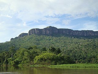
The Guayanan Highlands moist forests (NT0124) is an ecoregion in the south of Venezuela and the north of Brazil and in Guyana, Suriname, French Guiana. It is in the Amazon biome. It encompasses an upland region with diverse fauna and flora, which contains dramatic tepuis, or sandstone table mountains. The region has been inaccessible in the past and is generally fairly intact, apart from the north and northeast where large scale agriculture, ranching and mining operations are steadily encroaching on the ecosystem. New roads are opening the interior to logging, and planned dams will have a drastic impact on the riparian zones.

Alto Orinoco-Casiquiare Biosphere Reserve

The Alto Orinoco-Casiquiare Biosphere Reserve is a UNESCO biosphere reserve in the Venezuelan Amazon biome.

References

    1. 1 2 3 4 5 Negro-Branco moist forests – Myers.
    2. Hammond 2005, p. 491.
    3. WildFinder – WWF.
    4. 1 2 3 4 5 6 7 8 9 10 11 12 Sears & Marín.
    5. Río Negro-Juruá Moist Forests – WWF.

    Bibliography

    • Hammond, D. S. (2005), Tropical Forests of the Guiana Shield: Ancient Forests in a Modern World, CABI, ISBN   978-1-84593-092-9 , retrieved 9 March 2017
    • "Negro-Branco moist forests", Global Species, Myers Enterprises II, retrieved 2017-03-09
    • Río Negro-Juruá Moist Forests, WWF Global, retrieved 2017-03-09
    • Sears, Robin; Marín, César, Northern South America: Eastern Colombia into Venezuela and Brazil, WWF: World Wildlife Fund, retrieved 2017-03-10
    • WildFinder, WWF: World Wildlife Fund, retrieved 2017-03-09