Eastern Panamanian montane forests

Last updated
Eastern Panamanian montane forests (NT0122)
Panamanian montane forests.jpg
Montane forests of Panama
Ecology
Realm Neotropical
Biome Tropical and subtropical moist broadleaf forests
Geography
Area3,108 km2 (1,200 sq mi)
Countries Colombia, Panama
Coordinates 7°46′05″N77°43′52″W / 7.768°N 77.731°W / 7.768; -77.731 Coordinates: 7°46′05″N77°43′52″W / 7.768°N 77.731°W / 7.768; -77.731
Geology Chocó Basin
Climate typeAf: equatorial; fully humid

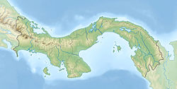
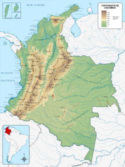
The Eastern Panamanian montane forests (NT0122) is an ecoregion in the east of Panama and the extreme northwest of Colombia. It contains diverse flora and fauna, with considerable endemism. The ecoregion is largely intact due to its inaccessibility, although the opening of an extension of the Pan-American Highway has introduced threats from human activity.

Contents

Geography

Location

Panama relief location map.jpg
Red pog.svg
Location in Panama

The ecoregion covers several separate areas of higher ground in Panama and the adjoining border region of Colombia. It has an area of 310,798 hectares (768,000 acres). [1] In the east the ecoregion is found on mountains surrounded by Chocó–Darién moist forests. Further west it is found on mountains surrounded by Isthmian-Atlantic moist forests.. [2]

Terrain

The region is one where the Caribbean Plate is riding over the Nazca Plate and the Cocos Plate, causing tectonic instability and volcanic activity. The Cordillera de San Blas and the Serranía del Darién are in the northeast, the latter containing the 1,875 metres (6,152 ft) Cerro Tacarcuna. The south holds isolated chains of mountains such as the Serrania de Jungurudó, the Serranía de Bagre and the Serranía del Baudó beside the Pacific coast. The Eastern Panamanian montane forests ecoregion lies at elevations above 500 metres (1,600 ft). [3]

Climate

Annual rainfall is typically 3,000 to 4,000 millimetres (120 to 160 in). The central mountains receive less rain, averaging 1,700 to 2,800 millimetres (67 to 110 in) while the mountains along the Caribbean coast receive 4,000 to 5,000 millimetres (160 to 200 in). [3] At a sample location at 8°15′N77°45′W / 8.25°N 77.75°W / 8.25; -77.75 the Köppen climate classification is Af: equatorial; fully humid. [4] Mean temperatures range from 26 °C (79 °F) in November to 27.3 °C (81.1 °F) in March. Annual rainfall is about 1,600 millimetres (63 in). Monthly rainfall varies from 12.7 millimetres (0.50 in) in March to 27.7 millimetres (1.09 in) in August. [4]

Ecology

The ecoregion is in the neotropical realm, in the tropical and subtropical moist broadleaf forests biome. [1]

Flora

Panama tree (Sterculia apetala) Arbol Panama - Sterculia apetala - Arbol Nacional de Panama 08.JPG
Panama tree ( Sterculia apetala )

The forests grow at altitudes from 500–1,800 metres (1,600–5,900 ft) in the Darién Province. At the upper levels the trees give way to páramo grasslands. The forests are complex, with great diversity and considerable endemism. Types of vegetation at the lower levels include semi-deciduous tropical moist forest, the most common form, as well as swamp forests and marshes. The semi-deciduous forest canopy trees include pochote ( Pachira quinata ), yuco de monte ( Pachira sessilis ), guanacaste ( Enterolobium cyclocarpum ), Licania hypoleuca , Platypodium elegans , ceibo barrigón ( Pseudobombax septenatum ), Panama tree ( Sterculia apetala ), nargusta ( Terminalia amazonia ), Tetragastris panamensis and taruma ( Vitex cymosa ). [3]

At higher elevations the dominant canopy tree in the premontane and montane wet forests is wild cashew ( Anacardium excelsum ). Other common canopy trees include Bombacopsis species, snakewood ( Brosimum guianense ), kapok tree ( Ceiba pentandra ), Cochlospermum orinocense , almendro ( Dipteryx panamensis ) and balsam of Peru (Myroxylon balsamum). Mapora palm ( Oenocarpus mapora ) is the dominant sub-canopy tree and Mabea occidentalis is the dominant shrub in the understory. Above 750 metres (2,460 ft) there are cloud forests dominated by mapora palm. Higher up there are elfin forests dominated by Clusia species. [3]

Fauna

The endemic Geoffroy's tamarin (Saguinus geoffroyi) Stavenn Saguinus geoffroyi 00.jpg
The endemic Geoffroy's tamarin (Saguinus geoffroyi)

The Eastern Panamanian montane forests ecoregion, situated on the land bridge between the Americas, and with different elevations and climates, has diverse fauna. Species from the north and south have mixed, and endemic species have appeared. Darien Province has about 770 species of vertebrates. Primates are gray-bellied night monkey (Aotus lemurinus – at the northern end of its range), Geoffroy's spider monkey (Ateles geoffroyi), black-headed spider monkey (Ateles fusciceps), Geoffroy's tamarin (Saguinus geoffroyi – endemic to Costa Rica, Panama and northwest Colombia), mantled howler (Alouatta palliata) and white-headed capuchin (Cebus capucinus). Cats are cougar (Puma concolor), jaguar (Panthera onca), ocelot (Leopardus pardalis), margay (Leopardus wiedii), jaguarundi (Puma yagouaroundi) and oncilla (Leopardus tigrinus). [3] Endangered mammals include black-headed spider monkey, Geoffroy's spider monkey and Baird's tapir (Tapirus bairdii). [5]

The ecoregion is the northernmost area for South American birds such as saffron-headed parrot (Pyrilia pyrilia), oilbird (Steatornis caripensis) and golden-headed quetzal (Pharomachrus auriceps). Endemic birds to the ecoregion also inhabit the Choco-Darién moist forests to the south. The restricted range birds are found at altitudes from 700 to 800 metres (2,300 to 2,600 ft). They include the bare-shanked screech owl (Megascops clarkii), beautiful treerunner (Margarornis bellulus), blue-and-gold tanager (Bangsia arcaei), green-naped tanager (Tangara fucosa), Nariño tapaculo (Scytalopus vicinior), Pirre hummingbird (Goldmania bella), Pirre warbler (Basileuterus ignotus), russet-crowned quail-dove (Zentrygon goldmani), sooty-faced finch (Arremon crassirostris), Tacarcuna bush tanager (Chlorospingus tacarcunae), Tacarcuna tapaculo (Scytalopus panamensis), Tacarcuna wood quail (Odontophorus dialeucos), varied solitaire (Myadestes coloratus), violet-capped hummingbird (Goldmania violiceps) and yellow-collared chlorophonia (Chlorophonia flavirostris). [3]

There are 24 species of endangered amphibians and reptiles in the Darién National Park. [3] Endangered amphibians include the horned marsupial frog (Gastrotheca cornuta). [5]

Status

The World Wide Fund for Nature (WWF) gives the ecoregion the status "Relatively Stable/Intact". It has avoided widespread damage due to its steep and inaccessible slopes, and there are still large, intact blocks. However, the opening of the Pan-American Highway has caused colonization from central Panama, with increases in slash-and-burn farming, gold mining and the illegal capture of macaws, parrots, and passerine birds for sale. [3]

The ridge of the Llorona San Blas is in the Kuna Indian Reserve of San Blas, and is protected by the indigenous Kuna people. The 5,790 square kilometres (2,240 sq mi) Darién National Park protects a large area of the ecoregion. Other protected areas are the Kuna de Walá Mortí, Nurrá and Comarca Emberá-Wounaan indigenous reserves, the 316 square kilometres (122 sq mi) Canglon Forest Reserve and the 1,460 square kilometres (560 sq mi) Chepigana Forest Reserve. [3]

Related Research Articles

Isthmian–Atlantic moist forests

The Isthmian–Atlantic moist forests (NT0129) are a Central American tropical moist broadleaf forest ecoregion located on the lowland slopes on the Gulf of Mexico side of Nicaragua and Costa Rica and the Gulf and Pacific Ocean sides of Panama. The forest species are a mix of North American and South American, as this region only became a land bridge in the past 3 million years.

Gurupa várzea

The Gurupa várzea (NT0126) is an ecoregion of seasonally and tidally flooded várzea forest along the Amazon River in the Amazon biome.

Monte Alegre várzea

The Monte Alegre várzea (NT0141) is an ecoregion of seasonally flooded várzea forest along the Amazon River in the Amazon biome.

Purus–Madeira moist forests

The Purus-Madeira moist forests (NT0157) is an ecoregion in the central Amazon basin. It is part of the Amazon biome. The ecoregion covers a stretch of flat and relatively infertile land between the Purus and Madeira rivers, extending to the Solimões River in the north. It is isolated from other regions by the seasonally flooded várzea forest along these rivers, and has a high degree of endemism among its flora and fauna. The natural environment is relatively intact. The BR-319 highway was built along the length of the ecoregion in the early 1970s, but rapidly deteriorated and is now closed.

Juruá–Purus moist forests

The Juruá–Purus moist forests (NT0133) is an ecoregion in northwest Brazil in the Amazon biome. The terrain is very flat and soils are poor. The rivers flood annually. There are no roads in the region, and the dense rainforest is relatively intact, although plans to extend the Trans-Amazonian Highway through the region would presumably cause widespread damage to the habitat.

Uatuma–Trombetas moist forests

The Uatuma-Trombetas moist forests (NT0173) is an ecoregion in northwest Brazil in the Amazon biome. It covers the Amazon basin north of the Amazon River from close to the Atlantic Ocean to the Rio Negro west of Manaus. The ecoregion is relatively intact, although it has been damaged along the main rivers and around population centers.

Cordillera Oriental montane forests

The Cordillera Oriental montane forests (NT0118) is an ecoregion in Venezuela and Colombia along the east slopes of the eastern cordillera of the Andes. The extensive region of submontane and montane forests includes distinctive flora and fauna in the north, center and southern sections. The ecoregion is home to numerous endemic species of fauna. Despite extensive changes due to logging, farming and ranching, large areas of the original habitat remain intact, and the ecoregion has rich biodiversity.

Catatumbo moist forests

The Catatumbo moist forests (NT0108) is an ecoregion in Venezuela and Colombia to the west and east of Lake Maracaibo. It includes four regions of moist forest on slightly higher ground than the dry forest and mangroves that surround the lake. The forest has unique flora related to the flora of the Amazon basin. It is badly degraded due to farming, livestock grazing and oil exploration.

Maracaibo dry forests

The Maracaibo dry forests (NT0222) is an ecoregion in Venezuela around Lake Maracaibo. It contains the country's main oil fields. The habitat is criss-crossed by roads and is severely degraded by farming and livestock grazing.

Napo moist forests

The Napo moist forests (NT0142) is an ecoregion in the western Amazon rainforest of Colombia, Ecuador and Peru.

Sinú Valley dry forests

The Sinú Valley dry forests (NT0229) is an ecoregion in the north of Colombia.

Magdalena–Urabá moist forests

The Magdalena–Urabá moist forests (NT0137) is an ecoregion in the north of Colombia. The terrain is largely flat or undulating, but includes mountainous areas in the south. It contains moist forests and large wetlands that are important to resident and migratory birds. The ecoregion forms a bridge between the Pacific coast ecoregions of Colombia and Central America, and the ecoregions of the Andes and Amazon. It is surrounded by the more populated parts of Colombia and is threatened by farming, ranching, logging, oil exploitation and water pollution in the main rivers.

Chocó–Darién moist forests

The Chocó–Darién moist forests (NT0115) is an ecoregion in the west of Colombia and east of Panama. The region has extremely high rainfall, and the forests hold great biodiversity. The northern and southern parts of the ecoregion have been considerably modified for ranching and farming, and there are threats from logging for paper pulp, uncontrolled gold mining, coca growing and industrialisation, but the central part of the ecoregion is relatively intact.

Northwestern Andean montane forests

The Northwestern Andean montane forests (NT0145) is an ecoregion on the Andes mountains in the west of Colombia and Ecuador. Both flora and fauna are highly diverse due to effect of ice ages when the warmer climate zones were separated and the cooler ones combined, and interglacial periods when the reverse occurred. Because the environment is hospitable to humans, the habitat has been drastically modified by farming and grazing since the Pre-Columbian era.

Magdalena Valley montane forests

The Magdalena Valley montane forests (NT0136) is an ecoregion in the Andes mountains of central Colombia.

Cauca Valley montane forests

The Cauca Valley montane forests (NT0109) is an ecoregion in western Colombia. It covers the sides of the Cauca Valley, which runs from south to north between the Central and Western Ranges (cordilleras) of the Colombian Andes. The ecoregion is home to very diverse fauna and flora, due in part to its varied elevations and climates, in part to its position near the isthmus of Panama, the route along which North American species invaded South America and then diversified as they moved to the upper parts of the Andes. Little of the original habitat remains at lower levels, but higher up there are sizeable blocks of forest, some of which ate protected.

Santa Marta montane forests

The Santa Marta montane forests (NT0159) is an ecoregion in the Sierra Nevada de Santa Marta, a massif on the Caribbean coast of northern Colombia. The ecoregion covers altitudes from near sea level up to around 3,300 metres (10,827 ft), where it gives way to Santa Marta páramo. The isolation of the massif and the range of elevations and climates has resulted in a wide variety of species including many endemics. The lower levels contained tropical rainforest, which has largely been cleared. Higher up, this gives way to cloud forest. Much of this has also been cleared for coffee plantations, pasture for sheep and cattle, and farming.

Eastern Cordillera Real montane forests

The Eastern Cordillera Real montane forests (NT0121) is an ecoregion in the eastern range of the Andes of southern Colombia, Ecuador and northern Peru. The ecoregion covers the eastern slopes of the Andes, and includes montane forest that rises from the Amazonian rain forest, with cloud forest and elfin forest at higher elevations. It is rich in species, including many endemics. It is threatened by logging and conversion for pasturage and subsistence agriculture.

Western Ecuador moist forests

The Western Ecuador moist forests (NT0178) is an ecoregion in the plains and western foothills of the Andes of southern Colombia and Ecuador. At one time this region contained dense forests with highly diverse flora and fauna, and many endemic species. Most of the original habitat has now been destroyed, and the ecoregion is one of the most threatened in the world.

South American Pacific mangroves ecoregion along the Pacific coast of Panama, Colombia, Ecuador and Peru.

The South American Pacific mangroves, or Panama Bight mangroves, is an ecoregion along the Pacific coast of Panama, Colombia, Ecuador and Peru.

References

    1. 1 2 Eastern Panamanian montane forests – Myers, WWF Abstract.
    2. WildFinder – WWF.
    3. 1 2 3 4 5 6 7 8 9 Powell, Palminteri & Schipper.
    4. 1 2 Eastern Panamanian montane forests – Myers, Climate Data.
    5. 1 2 Eastern Panamanian montane forests – Myers, All Endangered.

    Bibliography

    • "Eastern Panamanian montane forests", Global Species, Myers Enterprises II, retrieved 2017-06-14
    • Powell, George; Palminteri, Sue; Schipper, Jan, Central America: Panama and Colombia, WWF, retrieved 2017-06-14
    • WildFinder, WWF: World Wildlife Fund, retrieved 2017-06-14