Magdalena Valley dry forests

Last updated
Magdalena Valley dry forests (NT0221)
Barrios Occidente de Neiva - panoramio.jpg
West of Neiva, Huila, in the south of the dry valley
Ecoregion NT0221.png
Ecoregion territory (in purple)
Ecology
Realm Neotropical
Biome Tropical and subtropical dry broadleaf forests
Bird species297
Geography
Area19,748 km2 (7,625 sq mi)
Countries Colombia
Coordinates 4°00′N74°59′W / 4.0°N 74.98°W / 4.0; -74.98 Coordinates: 4°00′N74°59′W / 4.0°N 74.98°W / 4.0; -74.98
Geology Upper Magdalena Valley
Climate typeAm: equatorial, monsoonal
Conservation
Conservation status Critical/endangered

The Magdalena Valley dry forests (NT0221) is an ecoregion in Colombia along the upper Magdalena River, a large river that runs from south to north between the two main cordilleras of the Andes. There are many endemic species, but much of the original habitat has been destroyed by agriculture and over-grazing, mainly by goats. The habitat is not protected by any national park, and is at risk of complete destruction.

Contents

Location

The Magdalena Valley dry forests ecoregion is in the valley of the upper Magdalena River, a river that flows north through the Andes to the Caribbean. [1] It has an area of 19,748 square kilometres (7,625 sq mi). [2] The Magdalena River is the largest in Colombia. [3] The dry forests are almost entirely surrounded by the Magdalena Valley montane forests ecoregion. At its northern end the dry valley merges into the Magdalena–Urabá moist forests. It holds a small patch of the Northern Andean páramo ecoregion. [4]

Terrain

The Magdalena River runs from the Central Massif between the Eastern and Central Ranges of the Andes north to the Caribbean. The dry forest is in the upper section. Lower down the river runs through rainforest and then through swamps and wetlands. The average elevation of the dry forest section is 450 metres (1,480 ft). The valley floor is flat, with fertile alluvial soils and large deposits of ash from the Huila and Puracé volcanoes. [3] The dry Tatacoa Desert holds many vertebrate fossils dating from the Miocene era. [3]

The best soils are in areas with piedmont and alluvial valley landscapes, which cover 54.41% of the valley and are irrigated for agriculture. [5] Areas of structural-erosional mountainous landscape cover 18.13% of the area and have no value for farming, so may be conserved as protected areas. Most soils are neither strongly acidic nor alkaline, with pH levels of 5.8–7.5. [6] They have low or very low amounts of organic material, and low to medium levels of phosphorus. 69% of the soils are very susceptible to erosion and these mostly have low or very low natural fertility. Where these soils are not covered by vegetation they may be washed away during the rainy seasons. [6]

Climate

The Köppen climate classification is "Am": equatorial, monsoonal. [7] Annual rainfall in the Magdalena valley ranges from 831 to 2,268 millimetres (32.7 to 89.3 in), distributed over two distinct rainy seasons. [8] The rainy seasons last from April to July and from October to December. There is a water deficiency from April to September. [5] In the Tatacoa Desert there is less than 700 millimetres (28 in) of rain annually. [3] Mean annual temperature is 26.8 °C (80.2 °F). Temperatures rise to about 29.8 °C (85.6 °F) in July and August. [8]

Ecology

The Tatacoa Desert The Tatacoa Desert (4925602486).jpg
The Tatacoa Desert

The Magdalena Valley dry forests ecoregion is in the neotropical realm, in the tropical and subtropical dry broadleaf forests biome. [1]

Relation with other ecoregions

The Magdalena Valley dry forests ecoregion is part of the 103,000 square kilometres (40,000 sq mi) Tumbesian-Andean Valleys Dry Forests global ecoregion, which holds six terrestrial ecoregions: Tumbes–Piura dry forests, Ecuadorian dry forests, Patía Valley dry forests, Magdalena Valley dry forests, Cauca Valley dry forests and Marañón dry forests. The fauna and flora of the global ecoregion have high levels of endemism. [9]

The climate has varied during the present Quaternary period as glacial and inter-glacial cycles alternate. In glacial cycles the climate is drier and cooler by 2–8 °C (4–14 °F). Moist/wet forests retreat to refugia while the dry forests of the Magalena Valley extend to connect with other dry forests in Colombia and Venezuela, although the extremely humid Chocó region may remain a barrier between the northern dry forests and those of Ecuador and Peru. In inter-glacial cycles such as the present the warmer and more humid climate causes the moist forests to expand and dry forests to retreat into refugia. [10] In this model the dry pocket and surrounding forests are considered to be the Alto Magdalena Pleistocene refugium, a paleo-environment and a center of endemism. Many species of plants such as orchids, or birds and butterflies are endemic to the ecoregion. [3]

Flora

Vegetation in the Tatacoa Desert is thorny, and includes cactus species such as Opuntia and Melocactus species, Armatocereus humilis , Stenocereus griseus , Acanthocereus tetragonus and Pilosocereus colombianus . The dry central pocket also includes umbrella-shaped woody species under 15 metres (49 ft) including Pithecellobium bogotense , Capparis odoratissima , Bulnesia carrapo , Maclura tinctoria , Fagara pterota , Parkinsonia aculeta , Prosopis juliflora and Vachellia farnesiana . Above 2,800 metres (9,200 ft) the vegetation is replaced by montane cloud forest and páramo. Endemic plant species include Steriphoma colombiana , Amaria petiolata and Pithecellobium bogotense . The endemic and highly endangered May flower ( Cattleya trianae ), the national flower of Colombia, grows in the transition forests between the dry and moist regions. [3]

Fauna

The Magdalena River turtle (Podocnemis lewyana) is critically endangered. Magdalena River Turtle (Podocnemis lewyana), Medellin.jpg
The Magdalena River turtle (Podocnemis lewyana) is critically endangered.

There are some endemic subspecies including the burrowing owl (Athene cunicularia tolimae), crested bobwhite (Colinus cristatus leucotis), velvet-fronted euphonia (Euphonia concinna) and eastern cottontail (Sylvilagus floridanus purgatus). [3] Endangered mammals include the white-footed tamarin (Saguinus leucopus) and the mountain tapir (Tapirus pinchaque). [11] Endangered reptiles include the Magdalena River turtle (Podocnemis lewyana). [11] The region is home to the endangered tropical rattle snake Crotalus durissus . Other endemic or endangered species from the humid forests of the foothills include the Colombian weasel (Mustela felipei). [3]

Species that may be used as a source of income from supplying zoo nurseries, and thus less vulnerable, include red brocket (Mazama americana), white-tailed deer (Odocoileus virginianus), lowland paca (Cuniculus paca), Central American agouti (Dasyprocta punctata), eastern cottontail (Sylvilagus floridanus), tapeti (Sylvilagus brasiliensis), poison dart frog ( Dendrobates species), toad ( Bufo species), harlequin toad ( Atelopus species), tree frog ( Hyla species), rain frog ( Eleutherodactylus species), foam nest frog ( Leptodactylus species), spectacled caiman (Caiman crocodilus), green iguana (Iguana iguana) and boa constrictor (Boa constrictor). [12]

297 birds species have been reported, of which 35 were directly associated with the forest. [13] Migratory birds of the Thraupidae, Parulidae and Accipitridae families pass through the region. The western osprey (Pandion haliaetus) visits the north of the region in the winter. Parrots and hummingbirds migrate from higher regions. Long after it was thought to be extinct and the yellow-eared parrot (Ognorhynchus icterotis) was rediscovered in the region. The blue-billed curassow (Crax alberti) is no longer present. [3] Endangered birds include the recurve-billed bushbird (Clytoctantes alixii). [11]

The Magdalena River in Girardot, Cundinamarca, towards the north of the ecoregion Altodelasrosas01.jpg
The Magdalena River in Girardot, Cundinamarca, towards the north of the ecoregion

Status

The World Wildlife Fund gives the ecoregion the status of "Critical/Endangered". Much of the original habitat has been destroyed by agriculture and overgrazing, particularly by goats, leaving only a few forest patches along creeks and the Cabrera River in Tolima Department. Drilling and extraction of oil causes pollution around the Tatacoa desert. [3] The population is poor, with limited education, often living in unhygienic conditions in shanty towns around large farms. On flat soils that can be ploughed by tractor the most common type of farming is irrigated rice production, rotated with sorghum and cattle. Other farmers grow rain-fed sorghum with cotton, corn or sheep and cattle, or grow rain-fed sesame plants and fruit trees. [14]

As of 2001, 69% of the area had been transformed by human activity. Of 19,884.5 square kilometres (7,677.4 sq mi) total, 13,785.4 square kilometres (5,322.6 sq mi) had been converted to agricultural use. [15] There were no protected areas. [2] Maps of the region from the early 21st century show about 31 irregular and fragmented remnants of dry forest, with an average size of 155.5 hectares (384 acres). [16] The ecoregion is considered to be at high risk of complete destruction. [17]

Related Research Articles

<span class="mw-page-title-main">Uatuma–Trombetas moist forests</span>

The Uatuma–Trombetas moist forests (NT0173) is an ecoregion in northwest Brazil in the Amazon biome. It covers the Amazon basin north of the Amazon River from close to the Atlantic Ocean to the Rio Negro west of Manaus. The ecoregion is relatively intact, although it has been damaged along the main rivers and around population centers.

<span class="mw-page-title-main">Ecuadorian dry forests</span>

The Ecuadorian dry forests (NT0214) is an ecoregion near the Pacific coast of the Ecuador. The habitat has been occupied by people for centuries and has been severely damaged by deforestation, overgrazing and hillside erosion due to unsustainable agriculture. Only 1% of the original forest remains. The patches of forest, mostly secondary growth, are fragmented. They are home to many endemic species at risk of extinction.

<span class="mw-page-title-main">Tumbes–Piura dry forests</span>

The Tumbes–Piura dry forests (NT0232) is an arid tropical ecoregion along the Pacific coasts of southern Ecuador and northern Peru. The ecoregion contains many endemic species of flora and birds adapted to the short wet season followed by a long dry season. Threats include extraction of wood for fuel or furniture, and capture of wild birds for sale.

<span class="mw-page-title-main">Marañón dry forests</span>

The Marañón dry forests (NT0223) is an ecoregion in northern Peru. It covers the lower valley of the Marañón River and its tributaries along the eastern edge of the Andes. It has a dry climate due to rain shadow from mountains further east. The habitat has long been modified by farming, ranching and logging and is now threatened by construction of hydroelectric and irrigation dams.

<span class="mw-page-title-main">Patía Valley dry forests</span>

The Patía Valley dry forests (NT0225) is an ecoregion in southwestern Colombia. It covers a dry valley surrounded by mountains. The original habitat has mostly been destroyed by human activity, although a few pockets remain.

<span class="mw-page-title-main">Northern Andean páramo</span>

The Northern Andean páramo (NT1006) is an ecoregion containing páramo vegetation above the treeline in the Andes of Colombia and Ecuador. In the past, when the climate was cooler, the treeline and the páramo units were lower and the units were connected. During the present warmer Holocene epoch the páramos have migrated uphill, shrinking and becoming isolated. They contain many rare or endangered species, some of them restricted to a narrow area of one mountain or mountain range. The ecoregion is relatively well preserved, but faces threats from over-grazing and farming.

<span class="mw-page-title-main">Santa Marta páramo</span>

The Santa Marta páramo (NT1007) is an ecoregion containing páramo vegetation above the treeline in the Sierra Nevada de Santa Marta mountain range on the Caribbean coast of Colombia. The isolated position of the range has allowed unique species to evolve. Some are related to those found in Central America and the Caribbean coastal areas, and some to species from the Andes. The habitat is relatively stable, but has been drastically changed from the original by long-term human activity.

<span class="mw-page-title-main">Venezuelan Andes montane forests</span>

The Venezuelan Andes montane forests (NT0175) is an ecoregion in the northern arm of the Andes in Venezuela. It contains montane and cloud forests, reaching up to the high-level Cordillera de Merida páramo high moor ecoregion. The forests are home to many endemic species of flora and fauna. Their lower levels are threatened by migrant farmers, who clear patches of forest to grow crops, then move on.

<span class="mw-page-title-main">Apure–Villavicencio dry forests</span>

The Apure–Villavicencio dry forests (NT0201) is an ecoregion in Venezuela and Colombia to the east of the eastern cordillera of the Andes. The ecoregion covers the transition zone between montane forests in the Andes and the llanos, or lowland grasslands. It has been severely degraded by deforestation, farming and ranching. The remnants are poorly protected.

<span class="mw-page-title-main">Cordillera Oriental montane forests</span>

The Cordillera Oriental montane forests (NT0118) is an ecoregion in Venezuela and Colombia along the east slopes of the eastern cordillera of the Andes. The extensive region of submontane and montane forests includes distinctive flora and fauna in the north, center and southern sections. The ecoregion is home to numerous endemic species of fauna. Despite extensive changes due to logging, farming and ranching, large areas of the original habitat remain intact, and the ecoregion has rich biodiversity.

<span class="mw-page-title-main">Lara–Falcón dry forests</span>

The Lara-Falcón dry forests (NT0219) is an ecoregion that extends inland from the Caribbean coast of northwestern Venezuela. To the east and west the dry forests of the hilly region transition into xeric shrublands. There are several endemic bird species including the vulnerable yellow-shouldered amazon, in demand as a pet. There are few protected areas. Despite the relatively infertile soils, a large part of the ecoregion has been converted to farmland or pasturage.

<span class="mw-page-title-main">Sinú Valley dry forests</span>

The Sinú Valley dry forests (NT0229) is an ecoregion in the north of Colombia.

<span class="mw-page-title-main">Magdalena–Urabá moist forests</span> Ecoregion in Northern Colombia

The Magdalena–Urabá moist forests (NT0137) is an ecoregion in the north of Colombia. The terrain is largely flat or undulating, but includes mountainous areas in the south. It contains moist forests and large wetlands that are important to resident and migratory birds. The ecoregion forms a bridge between the Pacific coast ecoregions of Colombia and Central America, and the ecoregions of the Andes and Amazon. It is surrounded by the more populated parts of Colombia and is threatened by farming, ranching, logging, oil exploitation and water pollution in the main rivers.

<span class="mw-page-title-main">Chocó–Darién moist forests</span>

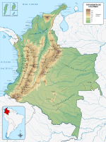
The Chocó–Darién moist forests (NT0115) is an ecoregion in the west of Colombia and east of Panama. The region has extremely high rainfall, and the forests hold great biodiversity. The northern and southern parts of the ecoregion have been considerably modified for ranching and farming, and there are threats from logging for paper pulp, uncontrolled gold mining, coca growing and industrialisation, but the central part of the ecoregion is relatively intact.

<span class="mw-page-title-main">Northwestern Andean montane forests</span>

The Northwestern Andean montane forests (NT0145) is an ecoregion on the Andes mountains in the west of Colombia and Ecuador. Both flora and fauna are highly diverse due to effect of ice ages when the warmer climate zones were separated and the cooler ones combined, and interglacial periods when the reverse occurred. Because the environment is hospitable to humans, the habitat has been drastically modified by farming and grazing since the Pre-Columbian era.

<span class="mw-page-title-main">Magdalena Valley montane forests</span>

The Magdalena Valley montane forests (NT0136) is an ecoregion in the Andes mountains of central Colombia.

<span class="mw-page-title-main">Cauca Valley montane forests</span>

The Cauca Valley montane forests (NT0109) is an ecoregion in western Colombia. It covers the sides of the Cauca Valley, which runs from south to north between the Central and Western Ranges (cordilleras) of the Colombian Andes. The ecoregion is home to very diverse fauna and flora, due in part to its varied elevations and climates, in part to its position near the isthmus of Panama, the route along which North American species invaded South America and then diversified as they moved to the upper parts of the Andes. Little of the original habitat remains at lower levels, but higher up there are sizeable blocks of forest, some of which are protected.

<span class="mw-page-title-main">Santa Marta montane forests</span>

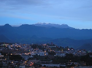
The Santa Marta montane forests (NT0159) is an ecoregion in the Sierra Nevada de Santa Marta, a massif on the Caribbean coast of northern Colombia. The ecoregion covers altitudes from near sea level up to around 3,300 metres (10,827 ft), where it gives way to Santa Marta páramo. The isolation of the massif and the range of elevations and climates has resulted in a wide variety of species including many endemics. The lower levels contained tropical rainforest, which has largely been cleared. Higher up, this gives way to cloud forest. Much of this has also been cleared for coffee plantations, pasture for sheep and cattle, and farming.

<span class="mw-page-title-main">Eastern Cordillera Real montane forests</span>

The Eastern Cordillera Real montane forests (NT0121) is an ecoregion in the eastern range of the Andes of southern Colombia, Ecuador and northern Peru. The ecoregion covers the eastern slopes of the Andes, and includes montane forest that rises from the Amazonian rain forest, with cloud forest and elfin forest at higher elevations. It is rich in species, including many endemics. It is threatened by logging and conversion for pasturage and subsistence agriculture.

<span class="mw-page-title-main">Western Ecuador moist forests</span>

The Western Ecuador Moist Forests (NT0178), also known as the Pacific Forest of Ecuador, is an ecoregion in the plains and western foothills of the Andes of southern Colombia and Ecuador. At one time this region contained dense forests with highly diverse flora and fauna, and many endemic species. Most of the original habitat has now been destroyed, and the ecoregion is one of the most threatened in the world.

References

    1. 1 2 Magdalena Valley dry forests – Myers, WWF Abstract.
    2. 1 2 Zimmerer 2006, p. 220.
    3. 1 2 3 4 5 6 7 8 9 10 Constantino.
    4. WildFinder – WWF.
    5. 1 2 Sanchez-Azofeifa et al. 2013, p. 42.
    6. 1 2 Sanchez-Azofeifa et al. 2013, p. 43.
    7. Magdalena Valley dry forests – Myers, Climate Data.
    8. 1 2 Sanchez-Azofeifa et al. 2013, p. 41.
    9. Schafer.
    10. Pennington & Ratter 2006, p. 274.
    11. 1 2 3 Magdalena Valley dry forests – Myers, All Endangered.
    12. Sanchez-Azofeifa et al. 2013, p. 47.
    13. Sanchez-Azofeifa et al. 2013, p. 46.
    14. Sanchez-Azofeifa et al. 2013, p. 45.
    15. Ferranti 2005, p. 91.
    16. Sanchez-Azofeifa et al. 2013, p. 40.
    17. Zimmerer 2006, p. 218.

    Bibliography

    • Constantino, Emilio, Northern South America: Western Colombia (NT0221), WWF: World Wildlife Fund, retrieved 2017-04-16
    • Ferranti, David M. De (1 January 2005), Beyond the City: The Rural Contribution to Development, World Bank Publications, ISBN   978-0-8213-6097-2 , retrieved 17 April 2017
    • "Magdalena Valley dry forests", Global Species, Myers Enterprises II, retrieved 2017-04-16
    • Pennington, R. Toby; Ratter, James A. (25 May 2006), Neotropical Savannas and Seasonally Dry Forests: Plant Diversity, Biogeography, and Conservation, CRC Press, ISBN   978-1-4200-0449-6 , retrieved 17 April 2017
    • Sanchez-Azofeifa, Arturo; Powers, Jennifer S.; Fernandes, Geraldo W.; Quesada, Mauricio (29 August 2013), Tropical Dry Forests in the Americas: Ecology, Conservation, and Management, CRC Press, ISBN   978-1-4665-1201-6 , retrieved 17 April 2017
    • Schafer, Kevin, Tumbesian-Andean Valleys Dry Forests, WWF: World Wildlife Fund, retrieved 2017-04-15
    • WildFinder, WWF: World Wildlife Fund, retrieved 2017-04-15
    • Zimmerer, Karl S. (15 September 2006), Globalization and New Geographies of Conservation, University of Chicago Press, ISBN   978-0-226-98344-8 , retrieved 17 April 2017