"},"adm_district_jur":{"wt":"[[Anadyrsky District]]"},"adm_district_jur_ref":{"wt":""},"inhabloc_cat":{"wt":"Urban-type settlement"},"inhabloc_cat_ref":{"wt":""},"inhabloc_type":{"wt":""},"inhabloc_type_ref":{"wt":""},"mun_district_jur":{"wt":"Anadyrsky Municipal District"},"mun_district_jur_ref":{"wt":""},"urban_settlement_jur":{"wt":"Ugolnye Kopi Urban Settlement"},"urban_settlement_jur_ref":{"wt":""},"mun_admctr_of":{"wt":"Ugolnye Kopi Urban Settlement"},"mun_admctr_of_ref":{"wt":""},"leader_title":{"wt":"Head of Administration"},"leader_title_ref":{"wt":"\"Self-Government\" All-Russia Information Agency. [http://gp5818.chukotski.msu-russia.ru/contacts.html Ugolnye Kopi] {{in lang|ru}}"},"leader_name":{"wt":"Pyotr Andrushchenko"},"leader_name_ref":{"wt":""},"9":{"wt":"representative_body\n"},"10":{"wt":"representative_body_ref\n\n"},"11":{"wt":"area_of_what\n"},"12":{"wt":"area_as_of\n"},"13":{"wt":"area_km2\n"},"14":{"wt":"area_km2_ref\n"},"pop_2010census":{"wt":"3368"},"pop_2010census_ref":{"wt":"{{ru-pop-ref|2010Census}}"},"pop_latest":{"wt":"3621"},"pop_latest_date":{"wt":"January 2018"},"pop_latest_ref":{"wt":"Office of the [[Russian Federal State Statistics Service|Federal State Statistics Service]] for Khabarovsk Krai, Magadan Oblast, Jewish Autonomous Oblast and Chukotka Autonomous Okrug. [http://habstat.gks.ru/wps/wcm/connect/rosstat_ts/habstat/resources/62f1a600408e9886a05deb4d45abe5e4/%D0%A7%D0%B8%D1%81%D0%BB%D0%B5%D0%BD%D0%BD%D0%BE%D1%81%D1%82%D1%8C+%D0%BD%D0%B0%D1%81%D0%B5%D0%BB%D0%B5%D0%BD%D0%B8%D1%8F+%D0%A7%D1%83%D0%BA%D0%BE%D1%82%D1%81%D0%BA%D0%BE%D0%B3%D0%BE+%D0%B0%D0%B2%D1%82%D0%BE%D0%BD%D0%BE%D0%BC%D0%BD%D0%BE%D0%B3%D0%BE+%D0%BE%D0%BA%D1%80%D1%83%D0%B3%D0%B0+%D0%BF%D0%BE+%D0%BC%D1%83%D0%BD%D0%B8%D1%86%D0%B8%D0%BF%D0%B0%D0%BB%D1%8C%D0%BD%D1%8B%D0%BC+%D0%BE%D0%B1%D1%80%D0%B0%D0%B7%D0%BE%D0%B2%D0%B0%D0%BD%D0%B8%D1%8F%D0%BC+%D0%BD%D0%B0+1+%D1%8F%D0%BD%D0%B2%D0%B0%D1%80%D1%8F+2018+%D0%B3%D0%BE%D0%B4%D0%B0.doc Численность населения Чукотского автономного округа по муниципальным образованиям на 1 января 2018 года] {{in lang|ru}}\n"},"established_date":{"wt":"beginning of the
20th century"},"established_title":{"wt":""},"established_date_ref":{"wt":""},"15":{"wt":"current_cat_date\n"},"16":{"wt":"current_cat_date_ref\n"},"17":{"wt":"prev_name1\n"},"18":{"wt":"prev_name1_date\n"},"19":{"wt":"prev_name1_ref\n\n"},"postal_codes":{"wt":"689500, 689501, 689503, 689504, 689506, 689510"},"dialing_codes":{"wt":"42722"},"dialing_codes_ref":{"wt":""},"website":{"wt":""},"20":{"wt":"website_ref\n"}},"i":0}}]}" id="mwBw">Urban-type settlement in Chukotka Autonomous Okrug, Russia
Ugolnye Kopi Угольные Копи | |
---|---|
Coordinates: 64°44′00″N177°42′00″E / 64.73333°N 177.70000°E | |
Country | Russia |
Federal subject | Chukotka Autonomous Okrug [1] |
Administrative district | Anadyrsky District [1] |
Founded | beginning of the 20th century [2] |
Government | |
• Head of Administration [3] | Pyotr Andrushchenko [3] |
Population | |
• Total | 3,368 |
3,621 | |
• Municipal district | Anadyrsky Municipal District [6] |
• Urban settlement | Ugolnye Kopi Urban Settlement [6] |
• Capital of | Ugolnye Kopi Urban Settlement [6] |
Time zone | UTC+12 (MSK+9 ![]() |
Postal code(s) [8] | 689500, 689501, 689503, 689504, 689506, 689510 |
Dialing code(s) | +7 42722 |
OKTMO ID | 77603157051 |
Ugolnye Kopi (Russian : У́гольные Ко́пи, lit. coal mines) is an urban locality (an urban-type settlement) in Anadyrsky District of Chukotka Autonomous Okrug, Russia, located east of Anadyr, the administrative center of the autonomous okrug, on the opposite side of the Anadyr River. It served as the administrative center of Anadyrsky District until June 2011. Population: 3,368 (2010 Census); [4] 3,863 (2002 Census); [9] 12,357 (1989 Soviet census), [10] with an estimated population as of January 1, 2015 of 3,666.
It is a mainly mining town that also hosts the region's main airport.
Traces of fossil flora and fauna dating to the late Cretaceous and Paleocene were discovered on the territory of modern Ugolnye Kopi in 2003, in the area known as the Golden Ridge, [11] in the Ugolnoye and Pervomaysky fields. These areas exhibit extensive fossil flora and fauna composition; the fossilized plant remains are well-preserved. [12] There are currently about 130 items in the Chukotka Heritage Museum in Anadyr. [13] [ failed verification ] Pollen grains extracted from the shells show that for about two million years ago coniferous and deciduous forests existed on the Gold Ridge.
In the sediments of the Golden Ridge, fossil remains of teeth, vertebrae, and jaw fragments have been found. [14]
It was founded at the beginning of the 20th century to provide accommodation and facilities for those working in or administering the nearby mines, hence the name, [2] and later to provide the same services to those working in the air industry at the local airport.
Within the framework of administrative divisions, Ugolnye Kopi is directly subordinated to Anadyrsky District. [1] As a municipal division, the urban-type settlement of Ugolnye Kopi is incorporated within Anadyrsky Municipal District as Ugolnye Kopi Urban Settlement. [6]
Ugolnye Kopi is located on the road between the Ugolny Airport and Shakhtyorsky. Unlike a large number of localities in the region, Ugolnye Kopi's demographics is mainly Caucasian. [15] The Red Cross reports that only eighty-four people in Ugolnye Kopi are of indigenous origin; [15] the remainder are of Slavic origin. [2] This is as a result of the settlement's reason for existence being to provide accommodation and services to the local miners, servicemen, and aircraftmen, rather than it initially being an indigenous settlement that was turned into a collective farm such as, for example, Chuvanskoye.
The settlement houses all district institutions and several military units. [15] There are various stores, a post-office, a library, a hostel for children, the District Center of Children's Art, a youth sports school, a daycare center, Chukotka Economic Lyceum, a high school, the Municipal Center of Education, and a cultural center. [15]
The settlement is also home to the main airport in the autonomous okrug, the Ugolny Airport. This is the main transport hub for the region offering vital links to all airports within the district with Chukotavia as well as Alaska through Bering Air. In summer, those arriving to the airport and heading to Anadyr may do so using a ferry crossing; however, winter arrivals need to use the ice road across the Anadyr River which leads straight into the town. [2]
In 2003, power cables were finally laid across the water from the Anadyr power station to these settlements. The use of natural gas as basic fuel will allow for the considerable improvement of the ecological situation in the autonomous okrug by decreasing the level of emissions in the atmosphere caused by coal burning. Hence the cost of power will drop, and reliability and quality of power supply will be higher.
Ugolnye Kopi has a polar climate (Köppen ET) [16] because the warmest month has an average temperature between 0 and +10 °C (32 and 50 °F).
Climate data for Ugolnye Kopi | |||||||||||||
---|---|---|---|---|---|---|---|---|---|---|---|---|---|
Month | Jan | Feb | Mar | Apr | May | Jun | Jul | Aug | Sep | Oct | Nov | Dec | Year |
Record high °C (°F) | 3.3 (37.9) | 3.4 (38.1) | 5.4 (41.7) | 4.6 (40.3) | 9.1 (48.4) | 22.8 (73.0) | 27.4 (81.3) | 27.5 (81.5) | 17.7 (63.9) | 10.8 (51.4) | 6.2 (43.2) | 1.9 (35.4) | 27.5 (81.5) |
Mean daily maximum °C (°F) | −13 (9) | −14.5 (5.9) | −13.2 (8.2) | −7.7 (18.1) | 0.3 (32.5) | 7.9 (46.2) | 12.6 (54.7) | 11.8 (53.2) | 6.4 (43.5) | −0.9 (30.4) | −8.1 (17.4) | −11.1 (12.0) | −2.3 (27.9) |
Mean daily minimum °C (°F) | −16.7 (1.9) | −18 (0) | −16.8 (1.8) | −11.8 (10.8) | −2.9 (26.8) | 2.6 (36.7) | 6.9 (44.4) | 6.9 (44.4) | 2.2 (36.0) | −4.5 (23.9) | −11.8 (10.8) | −14.8 (5.4) | −6.6 (20.1) |
Record low °C (°F) | −34.1 (−29.4) | −32.8 (−27.0) | −31 (−24) | −25 (−13) | −16.9 (1.6) | −3.4 (25.9) | 0.4 (32.7) | 0 (32) | −7.9 (17.8) | −21 (−6) | −27 (−17) | −32 (−26) | −34.1 (−29.4) |
Average precipitation mm (inches) | 57 (2.2) | 39 (1.5) | 24 (0.9) | 27 (1.1) | 27 (1.1) | 27 (1.1) | 39 (1.5) | 60 (2.4) | 60 (2.4) | 54 (2.1) | 66 (2.6) | 63 (2.5) | 543 (21.4) |
Average snowy days | 19 | 14 | 15 | 15 | 17 | 3 | 0 | 0 | 4 | 17 | 20 | 20 | 144 |
Source: [17] |
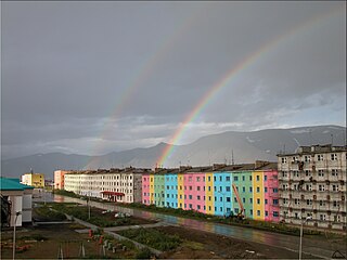
Provideniya is an urban locality and the administrative center of Providensky District of Chukotka Autonomous Okrug, Russia, located on Komsomolskaya Bay in the northeastern part of the autonomous okrug, across the Bering Strait from Alaska, and very close to the International Date Line. The population has declined in recent decades: 1,970 (2010 Census); 2,723 (2002 Census); 5,432 (1989 Soviet census).
Anadyr is a port town and the administrative center of Chukotka Autonomous Okrug, Russia, located at the mouth of the Anadyr River at the tip of a peninsula that protrudes into Anadyrsky Liman. It was previously known as Novo-Mariinsk. Anadyr is the easternmost town in Russia; more easterly settlements, such as Provideniya and Uelen, do not have town status.
Egvekinot is an urban locality and the administrative center of Iultinsky District in Chukotka Autonomous Okrug, Russia. The population is 2,790 (2010 Census).
Bilibino is a town and the administrative center of Bilibinsky District in Chukotka Autonomous Okrug, Russia. It is located 625 kilometers (388 mi) northwest of Anadyr, the administrative center of the autonomous okrug. It is the second largest town in the autonomous okrug after Anadyr. Population: 5,546 (2021 Census); 5,506 (2010 Census); 6,181 (2002 Census); 15,558 (1989 Soviet census).
Shakhtyorsky, is an urban-type settlement in Anadyrsky District of Chukotka Autonomous Okrug, Russia. As of 2008, it is in the process of being abolished due to it no longer being considered economically viable to continue mining in the area. Population: 328 ; 2,968 (1989 Soviet census). As a result of the cessation of mining activities, the population of the settlement has continued to decline. By 2005, an environmental impact report prepared for the Kupol Gold Project indicated that the population of Shakhtyorsky had fallen to just 93 people.
Anadyrsky District is an administrative and municipal district (raion), one of the six in Chukotka Autonomous Okrug, Russia. It is located in the central and southern parts of the autonomous okrug and borders with Chaunsky District in the northwest, Iultinsky District in the north and northeast, the Gulf of Anadyr in the east, Koryak Okrug in the south, and with Bilibinsky District in the west and northwest. It also completely surrounds the territory of the town of okrug significance of Anadyr. The area of the district is 287,900 square kilometers (111,200 sq mi). Its administrative center is the town of Anadyr. Population: 8,161 (2021 Census); 6,935 (2010 Census); 8,007 (2002 Census); 40,475 (1989 Soviet census).
Beringovsky District was an administrative district (raion) of Chukotka Autonomous Okrug, Russia, which existed in 1957–2011. As a municipal division, it was, together with Anadyrsky Administrative District, incorporated as Anadyrsky Municipal District. It was located on the southeastern shores of the autonomous okrug and bordered with Anadyrsky District in the west and the Bering Sea in the east. Its administrative center was the urban locality of Beringovsky. Population: 2,501 (2010 Census); 3,162 (2002 Census); 8,968 (1989 Soviet census). The area of the district was 37,900 square kilometers (14,600 sq mi).
Bilibinsky District is an administrative and municipal district (raion), one of the six in Chukotka Autonomous Okrug, Russia. It is located in the west of the autonomous okrug and borders with Chaunsky District in the northeast, Anadyrsky District in the east, Koryak Okrug of Kamchatka Krai in the southeast, Magadan Oblast in the southwest, and the Sakha Republic in the west. The area of the district is 174,652 square kilometers (67,434 sq mi). Its administrative center is the town of Bilibino. Population: 7,418 (2021 Census); 7,866 (2010 Census); 8,820 (2002 Census); 27,847 (1989 Soviet census). The population of Bilibino accounts for 74.8% of the district's total population.
Beringovsky is an urban locality in Anadyrsky District of Chukotka Autonomous Okrug, Russia, and a port on the Bering Sea. As of the 2010 Census, its population was 1,401.
Iultinsky District is an administrative and municipal district (raion), one of the six in Chukotka Autonomous Okrug, Russia. It is located in the northeast of the autonomous okrug and borders with the Chukchi Sea in the north, Providensky District in the east, Gulf of Anadyr in the southeast, and with Anadyrsky District in the southwest. The area of the district is 134,600 square kilometers (52,000 sq mi). Its administrative center is the urban locality of Egvekinot. Population: 4,329 (2010 Census); 3,974 (2002 Census); 15,689 (1989 Soviet census). The population of Egvekinot accounts for 64.4% of the district's total population.
Providensky District is an administrative and municipal district (raion), one of the six in Chukotka Autonomous Okrug, Russia. It is located in the northeast of the autonomous okrug, in the southern half of the Chukchi Peninsula with a northwest extension reaching almost to the Kolyuchinskaya Bay on the Arctic. It borders with Chukotsky District in the north, the Bering Sea in the east and south, and with Iultinsky District in the west. The area of the district is 26,800 square kilometers (10,300 sq mi). Its administrative center is the urban locality of Provideniya. Population: 3,923 (2010 Census); 4,660 (2002 Census); 9,778 (1989 Soviet census). The population of Provideniya accounts for 50.2% of the district's total population.
Krasneno is a rural locality in Anadyrsky District of Chukotka Autonomous Okrug, Russia, located southwest of Anadyr, the administrative center of the autonomous okrug. As of 2016, its population was estimated to be 63.
Kanchalan is a rural locality in Anadyrsky District of Chukotka Autonomous Okrug, Russia, located northwest of Anadyr, the administrative center of the autonomous okrug. As of the 2010 Census, its population was 629, with an estimated population as of 1 January 2015 of 525.
Vayegi is a rural locality in Anadyrsky District of Chukotka Autonomous Okrug, Russia, located near the border with Kamchatka Krai, on the banks of the river Mayn, southwest of Anadyr, the administrative center of the autonomous okrug. As of the 2010 Census, its population was 497.
Alkatvaam is a rural locality in Anadyrsky District of Chukotka Autonomous Okrug, Russia. Population: 299 (2010 Census); with an estimated population as of 1 January 2015 of 263. It is located on the Alkatvaam River just west of Beringovsky. Municipally, it is incorporated as Alkatvaam Rural Settlement.
Khatyrka is a rural locality in Anadyrsky District of Chukotka Autonomous Okrug, Russia, located on the shore of the Bering Sea southwest of Beringovsky. Population: 377 (2010 Census); with an estimated population of 323 as of 2018. Municipally, it is incorporated as Khatyrka Rural Settlement.
Meynypilgyno is a rural locality in Anadyrsky District of Chukotka Autonomous Okrug, Russia, located southwest of Beringovsky. Population: 424 (2010 Census); Municipally, it is incorporated as Meynypilgyno Rural Settlement.
Chuvanskoye is a rural locality in Anadyrsky District of Chukotka Autonomous Okrug. Russia, located west of Markovo on the banks of the Yeropol river, about 780 km from the mouth of the Anadyr. Population: 209 (2010 Census); with an estimated population as of 1 January 2015 of 188. Municipally, the village is incorporated as Chuvanskoye Rural Settlement.
Lamutskoye is a rural locality in Anadyrsky District of Chukotka Autonomous Okrug, Russia, located northwest of Markovo and 10 kilometers (6.2 mi) northeast of Chuvanskoye on the middle reaches of the Anadyr River. As of the 2010 Census, its population was 173.
Yanrakynnot is a rural locality in Providensky District of Chukotka Autonomous Okrug, Russia. Population: 338 (2010 Census); Municipally, Yanrakynnot is a part of Yanrakynnot Rural Settlement in Providensky Municipal District.