Ulcombe

Last updated

Ulcombe, Kent
All Saints' Church, Ulcombe - geograph.org.uk - 74189.jpg
All Saints Church
Kent UK location map.svg
Red pog.svg
Ulcombe, Kent
Location within Kent
Population890 (2011 Civil Parish including Chegworth) [1]
OS grid reference TQ846497
Shire county
Region
Country England
Sovereign state United Kingdom
Post town Maidstone
Postcode district ME17
Dialling code 01622
Police Kent
Fire Kent
Ambulance South East Coast
UK Parliament
List of places
UK
England
Kent
51°13′01″N0°38′33″E / 51.21708°N 0.64257°E / 51.21708; 0.64257 Coordinates: 51°13′01″N0°38′33″E / 51.21708°N 0.64257°E / 51.21708; 0.64257

Ulcombe is a village near the town of Maidstone in Kent, England. The name has evolved from 'Ullas-coomb', 'coomb' (pronounced 'coo-m') meaning 'a deep little wooded valley with Ulla as a personal name. There is no connection to owls. The original deserted Medieval village site lies to the east of the parish church in a valley. There is also a water-mill below this site, probably of early origins. It stands below the Greensand Way.

Contents

There is much evidence from recent archaeological fieldwork, undertaken under the direction of Neil Aldridge, for prehistoric and later occupation. A number of Palaeolithic hand-axes have been found to the east of Great Tong Bank, and are the result of solifluction over the last 70,000 years from an earlier river system. Lithic implements from the Mesolithic, Bronze Age and Neolithic periods show that the landscape was being used by early settlers. The Iron Age is the period when the local deposits of iron ore were being smelted and this continued into the Roman occupation of the 1st-3rd century AD. Near Jubilee Corner an Iron Age cremation cemetery was excavated along with an iron smelting site. A later Roman occupation site lay to the north, when excavated, two timber buildings, one of sill-beam construction, were recorded. [2]

The old village hall was dismantled and re-erected at the Museum of Kent Life, Sandling, having been made redundant by the construction of a new building. [3]

The manor of Ulcombe belonged to the St Leger family.

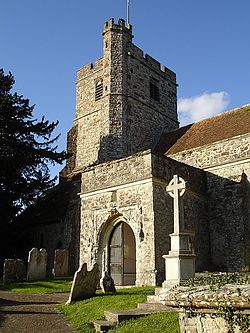
All Saints Church is a 12th-century Grade I listed building. It includes monuments of the St. Leger family, the Marquess and Marchioness of Ormonde, and Lady Sarah Wandesford, daughter of the Earl of Carrick.

In the 16th and 17th centuries Ulcombe was the location of a bell foundry run by three generations of the Hatch family, whose output included the bell known as "Bell Harry", after which the central tower of Canterbury Cathedral is known. [4]

In 2012, Hill House (a private house) won the Minor Residential category of the Kent Design Awards. [5]

Related Research Articles

Headcorn Human settlement in England

Headcorn is a village and civil parish in the borough of Maidstone in Kent, England. The parish is on the floodplain of the River Beult south east of Maidstone.

Bodiam Human settlement in England

Bodiam is a small village and civil parish in the Rother District of East Sussex, England. It lies in the valley of the River Rother, near to the villages of Sandhurst and Ewhurst Green.

Shutford Human settlement in England

Shutford is a village and civil parish about 4.5 miles (7.2 km) west of Banbury in Oxfordshire. The village is about 475 feet (145 m) above sea level. In 1870-72, John Marius Wilson's Imperial Gazetteer of England and Wales described Shutford like this:

Badlesmere, Kent Human settlement in England

Badlesmere is a village and civil parish in the Swale district of Kent, England, and about five miles south of Faversham.

Berwick St John Human settlement in England

Berwick St John is a village and civil parish in southwest Wiltshire, England, about 5 miles (8 km) east of Shaftesbury in Dorset.

Harty Human settlement in England

Harty is a small hamlet on the Isle of Sheppey in Kent consisting of a few cottages, a church and a public house, the Ferry Inn. It is part of the civil parish of Leysdown.

Broomfield, Maidstone Human settlement in England

Broomfield is a village in the Maidstone District of Kent, England, and forms part of the civil parish of Broomfield and Kingswood. It lies 6 miles (10 km) to the east of Maidstone. The village is located just upstream of Leeds Castle on the River Len, one of the tributaries of the River Medway.

Finmere Human settlement in England

Finmere is a village and civil parish in Oxfordshire, south of the River Great Ouse. It is on the county boundary with Buckinghamshire, almost 4 miles (6 km) west of Buckingham and just over 4 miles (6 km) east of Brackley in Northamptonshire. The 2011 Census recorded the parish's population as 466.

Preston-next-Wingham Human settlement in England

Preston or Preston-next-Wingham is a civil parish and village in valley of the Little Stour in the Dover District of Kent, England. The village is on the B2076 secondary road. The parish includes the hamlet of Elmstone. The main river through the area is a tributary of the River Stour. The suffix 'next-Wingham' distinguishes the area from Preston-next-Faversham and the Domesday Book chronicled Preston as 'Prestetune;

Smarden Human settlement in England

Smarden is a civil parish and village, west of Ashford in Kent, South East England.

Chastleton Human settlement in England

Chastleton is a village and civil parish in the Cotswold Hills in Oxfordshire, England, about 4 miles (6.4 km) northeast of Stow-on-the-Wold. Chastleton is in the extreme northwest of Oxfordshire, on the boundaries with both Gloucestershire and Warwickshire. The 2011 Census recorded the parish's population as 153.

Doddington, Kent Human settlement in England

Doddington is a village and civil parish in the district of Swale in Kent, England. The Syndale Valley shelters the central part in the Kent Downs Area of outstanding natural beauty. Today the village is notable for Doddington Place Gardens, for its remarkably well kept buildings and its house prices show higher prices than the home counties average.

Northmoor, Oxfordshire Human settlement in England

Northmoor is a village and civil parish in West Oxfordshire, about 6 miles (10 km) west of Oxford and almost the same distance southeast of Witney. Northmoor is in the valley of the River Thames, which bounds the parish to the east and south, and is close to the River Windrush which forms part of the parish's western boundary. The 2011 Census recorded the parish's population as 377.

Britford Human settlement in England

Britford is a village and civil parish beside the River Avon about 1.5 miles (2.4 km) southeast of Salisbury in Wiltshire, England. The village is just off the A338 road. The 2011 Census recorded a parish population of 592.

River Len River in Kent, England

The River Len is a river in Kent, England. It rises at a spring in Bluebell Woods to the southeast of the village centre of Lenham 0.6 miles (0.97 km) from the source of the River Great Stour; both rise on the Greensand Ridge. Its length is c10 miles (16 km). It enters the River Medway at Maidstone.

Langford, Oxfordshire Human settlement in England

Langford is a village and civil parish in West Oxfordshire, about 3 miles (5 km) northeast of Lechlade in neighbouring Gloucestershire. The 2011 Census recorded the parish's population as 349.

Leeds Priory Uk eclesiastic monument site

Leeds Priory, also known as Leeds Abbey, was a priory in Leeds, Kent, England, that was founded in 1119 and dissolved in 1539. A mansion was later built on the site of the priory; it was demolished in the late 18th century. The site of the former priory is a scheduled monument.

All Saints Church, Ulcombe Church in Kent, England

All Saints is a parish church in Ulcombe, Kent. It was begun in the 12th century and is a Grade I listed building.

St Marys Church, Reculver Church in Reculver, England

St Mary's Church, Reculver, was founded in the 7th century as either a minster or a monastery on the site of a Roman fort at Reculver, which was then at the north-eastern extremity of Kent in south-eastern England. In 669, the site of the fort was given for this purpose by King Ecgberht of Kent to a priest named Bassa, beginning a connection with Kentish kings that led to King Eadberht II of Kent being buried there in the 760s, and the church becoming very wealthy by the beginning of the 9th century. From the early 9th century to the 11th the church was treated as essentially a piece of property, with control passing between kings of Mercia, Wessex and England and the archbishops of Canterbury. Viking attacks may have extinguished the church's religious community in the 9th century, although an early 11th-century record indicates that the church was then in the hands of a dean accompanied by monks. By the time of Domesday Book, completed in 1086, St Mary's was serving as a parish church.

Hatch bell foundry English manufacturer of large bells, c.1581–1664

The Hatch bell foundry at Ulcombe, near Maidstone, in Kent, England, was operated by three generations of the Hatch family from 1581 or earlier until 1664. The bellfounders were based at nearby Broomfield from about 1587 until at least 1639. Joseph Hatch, bellfounder from 1602 to 1639, cast at least 155 bells, including "Bell Harry", after which the central tower of Canterbury Cathedral is named. Most Hatch bells were used in churches east of the River Medway in East Kent.

References

  1. "Civil Parish 2011". Neighbourhood Statistics. Office for National Statistics. Retrieved 15 September 2016.
  2. Archaeeologia Cantiana CXXV, 2005, pp 173-184, and KCC Heritage Database
  3. "Kent Life Weddings" (pdf). kentlife.org.uk. 2014. p. 8. Retrieved 27 May 2014.
  4. Stahlschmidt 1887 , pp. xiii, 74, 192, 195; Goodsall 1970 , pp. 20–38.
  5. "Hill House, Kent - 2012 RIBA Award Winner". www.workingmetals.co.uk. 2012. Archived from the original on 13 August 2013. Retrieved 23 December 2013.

Bibliography

Other sources

Commons-logo.svg Media related to Ulcombe at Wikimedia Commons