Otham

Last updated

Otham
Village sign, Otham - geograph.org.uk - 80485.jpg
The village sign
Kent UK location map.svg
Red pog.svg
Otham
Location within Kent
Population523 
OS grid reference TQ798536
District
Shire county
Region
Country England
Sovereign state United Kingdom
Post town MAIDSTONE
Postcode district ME15
Dialling code 01622
Police Kent
Fire Kent
Ambulance South East Coast
UK Parliament
Website Otham Parish Council
List of places
UK
England
Kent
51°15′07″N0°34′26″E / 51.252°N 0.574°E / 51.252; 0.574

Otham is a village and civil parish in the Maidstone district of Kent, England. The population of the civil parish at the 2011 census was 523, with 204 dwellings. [1]

Contents

Buildings

The village itself has been in existence since before the time of the Domesday Book. [2] The village was given by William the Conqueror to his half-brother Odo, bishop of Baieux, although the lands were later handed to the crown. Under Henry III, the land was held by knight Peter de Otham, with the land changing hands several more times throughout time. [3]

St Nicholas's Church St Nicholas Otham 1.jpg
St Nicholas's Church

One of the village's oldest buildings, the 12th-century parish church of St Nicholas, is a Grade I listed building. [4] The vicar is Reverend Steven Hughes MBE. Otham also has a number of listed mediaeval houses including Otham Manor (Grade I), [5] Synyards (Grade I) [6] and Stoneacre (Grade II*). [7] Stoneacre itself is a small National Trust property, which is a private residence but is opened to visitors on Saturdays and Bank Holiday Mondays from April to September.

Otham has a circular walk of 7 km which includes the Spot Lane Nature Reserve and Stoneacre. [8] Much of the central village is protected as part of the Otham Conservation Area, due to the village being a "well-preserved example of an affluent medieval village which still maintains a strong sense of identity". [9]

The White Horse pub is located in Otham. The White Horse Inn had two Publicans, the first William Goodwin (born in 1746) [10] and then his son, Solomon William Goodwin who was born in 1833.

Otham Manor was a 14th-century Wealden hall house, but was extensively modified in later centuries; it was most recently modified and extended in the 20th century. The property was Grade I listed in 1952; The Listing described it as a "GV I House, formerly cottages, now house. Late C14 with C16 alterations and additions. Restored circa 1912 by Sir Louis Mallet." [11] The estate was in a state of "semi-dereliction by the early 1990s" according to Country Life (magazine). It was subsequently restored by new owners and listed for sale in 2019. [12]

Sport

Bearsted F.C. play their home matches at Honey Lane in Otham, [13] and the village is also home to Rumwood Cricket Club. [2]

Development

The village of Otham is set to be expanded hugely over the next 10 years due to Maidstone Borough Council's Local Plan. The village currently has 204 dwellings, but is set to be expanded, with the construction of 1251 more on sites at Church Road (440 houses), Bicknor Farm (286 houses), Bicknor Green (190 houses) and Bicknor Farm (335 houses). [14] These constructions are opposed by the Parish Council, who state the construction is "likely to have a significant impact upon our village" and "will disproportionately affect Otham and nearby parishes". [15]

Related Research Articles

<span class="mw-page-title-main">Borough of Maidstone</span> Non-metropolitan district in England

The Borough of Maidstone is a local government district with borough status in Kent, England. Its administrative centre is Maidstone, the county town of Kent.

<span class="mw-page-title-main">Bearsted</span> Village in Kent, England

Bearsted is a village and civil parish with railway station in mid-Kent, England, two miles (3.2 km) east of Maidstone town centre.

<span class="mw-page-title-main">Hollingbourne</span> Village near Maidstone, Kent, England

Hollingbourne is a village and civil parish in the borough of Maidstone in Kent, England. The parish is located on the southward slope of the North Downs to the east of the county town, Maidstone. The parish population is around 900 and has three conservation areas: Upper Street in the village centre and the outlying hamlets of Broad Street and Eyhorne Street.

<span class="mw-page-title-main">Thurnham, Kent</span> Village in Kent, England

Thurnham is a village and civil parish which lies at the foot of the North Downs 3 miles (4.8 km) north east of Maidstone in the Borough of Maidstone and ceremonial county of Kent in England. It had a population of 1,085 in 2001 including Weavering, which increased to 1,205 following the 2011 Census.

<span class="mw-page-title-main">Wormshill</span> Village and civil parish in Kent, England

Wormshill, historically Wormsell, is a small village and civil parish within the Borough of Maidstone, Kent, England. The parish is approximately 7 miles (11 km) south of the Swale and 8 mi (13 km) east of Maidstone. The village of Frinsted lies 0.6 mi (1 km) to the east and Bicknor 1+12 mi (2.4 km) to the north-west; while Hollingbourne is 3 mi (5 km) to the south-west. The village lies on an exposed high point of the North Downs, within the Kent Downs Area of Outstanding Natural Beauty.

<span class="mw-page-title-main">Harrietsham</span> Village in Kent, England

Harrietsham is a rural and industrial village and civil parish in the Maidstone District of Kent, England noted in the Domesday Book. According to the United Kingdom Census 2001, it had a population of 1,504, increasing to 2,113 at the 2011 Census. The parish is in the North Downs, 7 miles (10 km) east of Maidstone and includes the settlements of Marley, Pollhill and Fairbourne.

<span class="mw-page-title-main">Lydiard Park</span> Public space and historic house in Swindon, England

Lydiard Park is a 260-acre (110-hectare) country park at Lydiard Tregoze, which was its former name, about 3 miles (5 km) west of central Swindon, Wiltshire, England, near Junction 16 of the M4 motorway.

<span class="mw-page-title-main">Stalisfield</span> Human settlement in England

Stalisfield is a village in the borough of Swale in Kent, England, located on a secondary road about 1½ miles (2.4 km) north of Charing and 5 miles south west of Faversham. The parish includes the hamlet of Stalisfield Green.

<span class="mw-page-title-main">Sheldwich</span> Human settlement in England

Sheldwich is a village and civil parish in the far south of the Borough of Swale in Kent, England.

Downswood is a civil parish in the Borough of Maidstone in Kent, England. The population of the civil parish at the 2011 census was 2,291. It is bounded to the north by the River Len and Bearsted, and to the south by Otham, and is 2 miles (3 km) from Maidstone, the county town of Kent. Downswood has been a parish in its own right since 1987. Prior to this it was part of the civil parish of Otham.

<span class="mw-page-title-main">Stockbury</span> Human settlement in England

Stockbury is a village and civil parish in the Maidstone district of Kent, England. The population of the civil parish at the Census 2011 was 691.

<span class="mw-page-title-main">Mote Park</span> Park in Kent, United Kingdom

Mote Park is a 440-acre (1.8 km2) multi-use public park in Maidstone, Kent. Previously a country estate it was converted to landscaped park land at the end of the 18th century before becoming a municipal park. It includes the former stately home Mote House together with a miniature railway and a boating lake. A ground of the same name within the park has also been used as a first-class cricket ground by Kent County Cricket Club.

<span class="mw-page-title-main">Stoneacre, Kent</span> Historic site in Kent, England

Stoneacre is a small National Trust property in Otham, near Maidstone, Kent in southern England. The property is a half-timbered yeoman farmer's house dating from the 15th century, together with a small garden, orchard and meadows. The house is a Grade II* listed building.

<span class="mw-page-title-main">Archbishop's Palace, Maidstone</span> Building in Maidstone, England

The Archbishop's Palace is a Grade I listed historic 14th-century and 16th-century building on the east bank of the River Medway in Maidstone, Kent. Originally a home from home for travelling archbishops from Canterbury, the building has been most recently used as a venue for wedding services. The former tithe barn for the palace, now serves as the Tyrwhitt-Drake Museum of Carriages.

<span class="mw-page-title-main">All Saints Church, Maidstone</span> Church in Kent , England

All Saints is a parish church in Maidstone, Kent. It is a Grade I listed building, and has been described as the grandest Perpendicular style church in Kent.

<span class="mw-page-title-main">Holy Cross Church, Bearsted</span> Church in Kent, England

Holy Cross is a parish church of the Church of England in Bearsted, Kent. Its construction begun in the 13th century.

<span class="mw-page-title-main">Grade I listed buildings in Maidstone</span>

There are 42 Grade I listed buildings in Maidstone. The Borough of Maidstone is a local government district in the English county of Kent. The district covers a largely rural area of 152 square miles (394 km2) between the North Downs and the Weald with the town of Maidstone, the county town of Kent, in the north-west. The district has a population of approximately 166,400 in 2016.

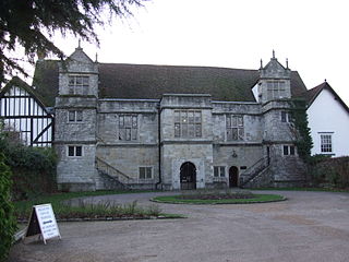
Otham Manor, previously known as Wardes, is a late 14th-century manor house in Otham, Kent.

Synyards is a late 15th-century house in Otham, Kent.

<span class="mw-page-title-main">2011 Maidstone Borough Council election</span> 2011 UK local government election

Elections to Maidstone Borough Council were held on 5 May 2011. One-third of the borough council were up for election. Parish council elections and the national Alternative Vote referendum were held on the same day.

References

  1. "Civil Parish population 2011". Neighbourhood Statistics. Office for National Statistics. Retrieved 16 September 2016.
  2. 1 2 "Otham Parish Council". Otham Parish Council. Retrieved 17 January 2018.
  3. Hasted, Edward (1798). The History and Topographical Survey of the County of Kent. Vol. Five. Canterbury: W Bristow. pp. 513–519. Retrieved 17 January 2018.
  4. Historic England. "Church of Saint Nicholas (1250738)". National Heritage List for England . Retrieved 3 September 2011.
  5. Historic England. "Otham Manor (1250941)". National Heritage List for England . Retrieved 3 September 2011.
  6. Historic England. "Synyards and Path Between Front Door and Road (1263084)". National Heritage List for England . Retrieved 3 September 2011.
  7. Historic England. "Stoneacre and Path Between Front Door and Road (1250995)". National Heritage List for England . Retrieved 3 September 2011.
  8. "Walk Maidstone 7 - Otham" (PDF). Maidstone Borough Council. Retrieved 17 January 2018.
  9. "Otham Conservation Area Appraisal" (PDF). Maidstone Borough Council. 27 February 2009. Retrieved 17 January 2018.
  10. English Post Office Records.[ not specific enough to verify ]
  11. Otham Manor List Entry Number 1250941
  12. The beautiful Grade I-listed 650-year-old manor house and gardens which survived dereliction twice, now lovingly restored
  13. Contact Bearsted Football Club Bearstead F.C.
  14. "MAIDSTONE BOROUGH LOCAL PLAN" (PDF). Maidstone Borough Council. 25 October 2017. Retrieved 17 January 2018.
  15. "MBC Local Plan". Otham Parish Council. 24 November 2016. Retrieved 17 January 2018.