
Thurston County is a county located in the U.S. state of Washington. As of the 2020 census, its population was 294,793. The county seat and largest city is Olympia, the state capital.

Union Hill-Novelty Hill is a census-designated place (CDP) in King County, Washington, United States. The area was first recognized by the Census Bureau in the 2000 census. The population was 18,805 at the 2010 census.

Lacey is a city in Thurston County, Washington, United States. It is a suburb of Olympia with a population of 53,526 at the 2020 census, making it the 24th most populous city in Washington. Lacey is located along Interstate 5 between Olympia and the Nisqually River, which marks the border with Pierce County and Joint Base Lewis–McChord.

The Nisqually Reservation, also known as Nisqually Indian Reservation is a federally recognized Indian reservation in Thurston County, Washington, United States. The population was 668 at the 2020 census.

The Capitol State Forest is a 110,000-acre (450 km2) state forest in Thurston and Grays Harbor counties of the U.S. state of Washington. It includes part of the unusual Mima Mounds geologic feature.
Mushroom Corner is an unincorporated community in Thurston County, Washington, United States. Mushroom Corner is located in the urban growth area of Lacey, along Interstate 5 outside of Olympia, and is included in the Tanglewilde-Thompson Place Census-designated place (CDP) for Census purposes. The "corner" in Mushroom Corner is located at the intersection of Steilacoom Road SE and Marvin Road SE.
Browns Point is a census-designated place (CDP) in Pierce County, Washington, United States, bordered by Tacoma on the east and Puget Sound on all other sides. The population was 1,198 at the 2010 census. The Tacoma neighborhood immediately adjacent to Browns Point is also referred to locally as "Browns Point".
Eld Inlet is an inlet located at the southern end of Puget Sound in Thurston County, Washington. It is the second southernmost arm of Puget Sound after neighboring Budd Inlet.

The Puget Sound region is a coastal area of the Pacific Northwest in the U.S. state of Washington, including Puget Sound, the Puget Sound lowlands, and the surrounding region roughly west of the Cascade Range and east of the Olympic Mountains. It is characterized by a complex array of saltwater bays, islands, and peninsulas carved out by prehistoric glaciers.
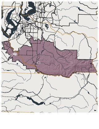
Washington's 2nd legislative district is one of forty-nine districts in Washington state for representation in the state legislature. The district runs mostly east-west along the southern extreme of Pierce County but also includes part of Thurston County, including Yelm and Lacey.
Boulevard Park is a census-designated place (CDP) in King County, Washington, United States. The population was 5,287 at the 2010 census. Boulevard Park was part of the Riverton-Boulevard Park CDP in 2000 but was split for the 2010 census into its own CDP.
Offutt Lake is an unincorporated community in Thurston County, in the U.S. state of Washington. The community is situated around Offutt Lake and is east of Millersylvania State Park. The populated area of Skookumchuck lies to the east and the city of Tenino is roughly south.
Johnson Point is a point in the U.S. state of Washington.
McIntosh is an unincorporated community in Thurston County, in the U.S. state of Washington. The community is situated around McIntosh Lake off Washington State Route 507 between the cities of Tenino and Rainer.
Plumb is an unincorporated community in Thurston County, in the U.S. state of Washington. The community is located to the west of nearby Offutt Lake and lies in and around the Rocky Prairie Natural Area Preserve.
Puget is an unincorporated community in Thurston County, in the U.S. state of Washington. The area is located on the Johnson Point peninsula overlooking Nisqually Reach.
Rignall is an unincorporated community in Thurston County, in the U.S. state of Washington. It is located on the Steamboat Island peninsula, overlooking the confluence of the Eld Inlet and Budd Inlet.
Vail is an unincorporated community in Thurston County, in the U.S. state of Washington. The community lies south of Rainier and Washington State Route 507.
Woodland Creek is a stream in Thurston County in the U.S. state of Washington. It is a tributary to Henderson Inlet.
The Nisqually Reach is a portion of Puget Sound south of the Tacoma Narrows, near the Nisqually River delta. It is classified as a bay by the United States government. It was originally defined as "the portion of the Sound lying between Anderson Island and the mainland".


