
The 4 Lazy F Ranch, also known as the Sun Star Ranch, is a dude ranch and summer residence in Jackson Hole, Wyoming, built by the William Frew family of Pittsburgh in 1927. The existing property was built as a family retreat, not as a cattle ranch, in a rustic style of construction using logs and board-and-batten techniques. The historic district includes seven cabins, a lodge, barn corral and smaller buildings on the west bank of the Snake River north of Moose, Wyoming. The property was added to the National Register of Historic Places in 1990.

The Parting of the Ways is an historic site in Sweetwater County, Wyoming, United States, where the Oregon and California Trails fork from the original route to Fort Bridger to an alternative route, the Sublette-Greenwood Cutoff, across the Little Colorado Desert. Many wagon trains parted company, some preferring the shorter cutoff route, which involved fifty waterless miles, to the longer but better-watered main route.

The Evanston Main Post Office in Evanston, Wyoming was built in 1905 as part of a facilities improvement program by the United States Post Office Department. The post office in Evanston was nominated to the National Register of Historic Places (NRHP) as part of a thematic study comprising twelve Wyoming post offices built to standardized USPO plans in the early twentieth century. It was NRHP-listed as U.S. Post Office-Evanston Main.
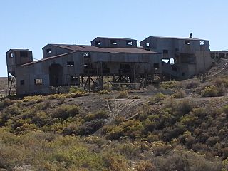
The Reliance Tipple is the site of two coal tipples associated with coal production at Reliance, Wyoming. The first tipple was built in 1910 and used until 1936. The wood structure was built on a sandstone foundation and served Reliance Mines No. 1 through No. 6. The perishable portions of the earlier tipple have disappeared, leaving only the sandstone foundations and some artifacts buried in the tailings pile.

The Sweetwater Brewery, also known as the Green River Brewery, was built in 1900 in Green River, Wyoming. The present structure is the surviving remnant of a three-building complex comprising an office/saloon, engine house, and the present brewery building. It was the first brewery in Wyoming, with operations dating to 1872 when Adam Braun began the business, the first of a series of ethnic German brewers. The brewery was further developed by Otto Rauch and Karl Spinner. The present structure was built by the fourth proprietor, Hugo Gaensslen, a Chicagoan who decorated the building with turrets reminiscent of the Chicago Water Tower.
This is a list of the National Register of Historic Places listings in Sublette County, Wyoming. It is intended to be a complete list of the properties and districts on the National Register of Historic Places in Sublette County, Wyoming, United States. The locations of National Register properties and districts for which the latitude and longitude coordinates are included below, may be seen in a map.

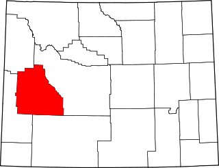
This is a list of the National Register of Historic Places listings in Sweetwater County, Wyoming.
Point of Rocks may refer to:

The South Superior Union Hall was built in 1921 in the southern part of what is now Superior, Wyoming. The hall was built by six locals of the United Mine Workers to accommodate union and community activities in the coal-mining community of Superior. Built in 1921, the two-story brick hall's plan is a parallelogram, though to be unique for its time in Wyoming. The hall housed doctors' and dentists' offices, a bowling alley and a grocery store. Dances were held in the upstairs meeting space.. With the closing of the Superior mines in the 1960s the union hall was sold in 1964. The hall was converted to a cafe, but the business did not prosper and the hall was abandoned.
William R. Dubois (1879-1953) was an American architect. He was a prolific architect in Wyoming and nearby states.
Standard Bridge Company was an American bridge company that was "one of the most important bridge building firms in Nebraska history."

The ENP Bridge over Green River is a historic bridge located near Daniel, Wyoming, which carries Sublette County Road CN23-145 across the Green River. The Western Bridge and Construction Company built the bridge circa 1905. The 221-foot-11-inch (67.64 m) bridge has two spans, both Pratt trusses; the longer span is a Pratt through truss, while the shorter is a Pratt pony truss. The use of both through and pony trusses in the same bridge was uncommon in Wyoming, and the bridge is the only surviving example of a Pratt truss bridge in this style.

The ETD Bridge over Green River is a steel girder bridge near Fontenelle, Wyoming, which carries Sweetwater County Road CN4-8SS over the Green River. The bridge is a replacement for a historic Pratt through truss bridge built in 1913 by the Colorado Bridge and Construction Company. The 150-foot-long (46 m) bridge was one of the longest Pratt through truss bridges built in the early stages of Wyoming bridge construction.

The ETR Big Island Bridge is a Pratt through truss bridge located near Green River, Wyoming, which carries Sweetwater County Road CN4-4 across the Green River. The bridge was built from 1909 to 1910 by contractor Charles G. Sheely. It was named the Big Island Bridge after the Big Island region of Wyoming, which the bridge connected to other parts of the state. The 352-foot (107 m), two-span bridge is one of the older Pratt through truss bridges in Wyoming, and its spans, each 155 feet (47 m) long, are some of the longest on bridges of this design in the state.

The DMJ Pick Bridge is a Parker through truss bridge located near Saratoga, Wyoming, which carries Carbon County Road CN6-508 across the North Platte River. The bridge was built from 1909 to 1910 by contractor Charles G. Sheely; it was originally located south of Fort Steele. In 1934, the bridge was moved up the river to its current location, as a new bridge had been built at its original site five years earlier. The bridge is the only Parker truss bridge remaining in Wyoming, after the Arvada Bridge was replaced in 1990.

The DML Butler Bridge is a Camelback through truss bridge located near Encampment, Wyoming, which carries Carbon County Road CN6-203 across the North Platte River. Contractor Chris O'Neil built the bridge in 1920 to replace a wooden bridge built in 1905. The bridge is one of two Camelback truss bridges remaining on a Wyoming county highway and, at 170 feet (52 m) long, is the longer of the two.

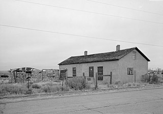
The Point of Rocks Stage Station is a former resting place at the meeting point of the Overland Trail and the Union Pacific Railroad in Sweetwater County, Wyoming, USA. It was built as a stop for the Overland Stage Line in the 1861 or 1862, equidistant between the earlier Black Buttes and Salt Wells stations, which were 28 miles (45 km) apart. The station served the stage line from 1862 to 1868. In 1868, the Union Pacific line reached Point of Rocks, putting the stage line out of business. The station then became a freight depot for nearby mines, with a road leading to Atlantic City and South Pass. The freight activity declined, and in 1877, the station became a residence. At one point it was allegedly inhabited by Jim McKee, a former member of the Hole in the Wall Gang. It became the property of the state of Wyoming in 1947 and is administered as Point of Rocks Stage Station State Historic Site.
Granger Station State Historic Site, also known as Granger Stage Station, South Bend Station and Ham's Fork Station, is a Wyoming state park dedicated to the interpretation of the station, the Pony Express and the Overland Trail. A settlement was first established about 1856 at the meeting of Ham's Fork with Black's Fork of the Green River, where a ferry crossed Ham's Fork. This became a station on the Pony Express in 1860-1861, then was a station on the Overland Trail in 1862. By this time it was known as the South Bend Station. In 1868 the trail was superseded when the Union Pacific Railroad arrived at the site. The station was deeded to the State of Wyoming in 1930. It is operated as a state historic site. The Granger Station was placed on the National Register of Historic Places on February 26, 1970.

Split Rock, also known as Twin Peaks, is a mountain in the Granite Mountains of central Wyoming. The peak has an elevation of 7,305 feet (2,227 m), and is located about 10 miles (16 km) north of the Muddy Gap junction between Casper and Rawlins. The mountain is distinctive for a deep V-shaped cleft dividing its summit. The mountain was a prominent landmark on the Oregon Trail and other early settlement routes in the region, which crossed a low rise at the eastern end of the range between Casper and the North Platte River valley and the Sweetwater River.
The Eldon-Wall Terrace Site is an archeological site in Sweetwater County, Wyoming. The site occupies about 600 metres (2,000 ft) of a terrace on Blacks Fork in the Green River Basin. The site includes numerous hearth sites, with stone chips and tools. A projectile point dates the site to the Middle Archaic period. The site was listed on the National Register of Historic Places on December 13, 1985.


