
The Brown Covered Bridge is a wooden covered bridge in Shrewsbury, Vermont. Located in the northwestern part of the town, it carries Upper Cold River Road over the Cold River. It was closed to vehicular traffic in 2011 due to damage from Hurricane Irene and reopened as a National Historic Site on July 5, 2016. Built in 1880 by noted Vermont bridgewright Nichols M. Powers, it was designated a National Historic Landmark in 2014, cited as one of the finest and least-altered examples of a Town lattice truss covered bridge in the United States.

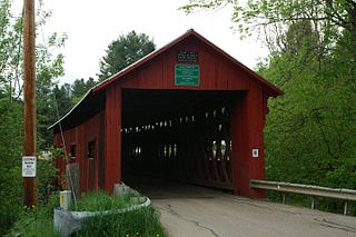
The Bartonsville Covered Bridge is a wooden covered bridge in the village of Bartonsville, in Rockingham, Vermont, United States. The bridge is a lattice truss style with a 151-foot span, carrying Lower Bartonsville Road over the Williams River. It was built in 2012, replacing a similar bridge built in 1870 by Sanford Granger. The 1870 bridge, which was listed on the National Register of Historic Places, was destroyed in 2011 in flooding caused by Hurricane Irene.

The Worrall Covered Bridge, also known as the Woralls Bridge is a wooden covered bridge carrying Williams Road across the Williams River in Rockingham, Vermont, United States. Built about 1870, it is the only surviving 19th-century covered bridge in the town, after the Hall Covered Bridge collapsed in 1980 and was replaced in 1982, and the Bartonsville Covered Bridge was washed away by Hurricane Irene in 2011 and replaced in 2012-2013. The bridge was listed on the National Register of Historic Places in 1973.

The Kingsley Covered Bridge is a wooden covered bridge carrying East Street across the Mill River in Clarendon, Vermont. Built about 1870, it is the town's only surviving 19th-century covered bridge. The bridge was listed on the National Register of Historic Places in 1974.

Gold Brook Covered Bridge, also known as Stowe Hollow Bridge or Emily's Bridge, is a small wooden covered bridge in the town of Stowe, Lamoille County, Vermont, carrying Covered Bridge Road over Gold Brook. Built in 1844, it is the only 19th-century covered bridge in the state built using wooden Howe trusses and carrying a public roadway. It was added to the National Register of Historic Places in 1974.

The Arlington Green Covered Bridge is a covered bridge located off Vermont Route 313 in Arlington, Vermont. The Town lattice truss bridge carries Covered Bridge Road across Batten Kill. It was built in 1852 and was listed on the National Register of Historic Places in 1973. It is one of Vermont's oldest surviving bridges.

The Stony Brook Covered Bridge, also called the Moseley Covered Bridge, is a wooden covered bridge that crosses Stony Brook in Northfield, Vermont on Stony Brook Road. Built in 1899, it is one of two surviving 19th-century King post truss bridges in the state. It was listed on the National Register of Historic Places in 1974.
The Northfield Falls Covered Bridge, also called the Station Covered Bridge, is a wooden covered bridge that carries Cox Brook Road across the Dog River in Northfield, Vermont. Built in 1872, this Town lattice truss bridge is one of five surviving covered bridges in the town, and one of two that are visible from each other. It was listed on the National Register of Historic Places in 1974.

The Slaughter HouseCovered Bridge is a wooden covered bridge that carries Slaughterhouse Road across the Dog River in Northfield, Vermont. The Queen post truss bridge is one of five surviving 19th-century bridges in the town. It was listed on the National Register of Historic Places in 1974.

The Lower Cox Brook Covered Bridge is a wooden covered bridge that crosses Cox Brook in Northfield, Vermont on Cox Brook Road. Built in 1872, it is one of five surviving 19th-century covered bridges in the town, in the only place in Vermont where two historic bridges are visible from each other. It was listed on the National Register of Historic Places in 1974.

The Pine Brook Covered Bridge, also called the Wilder Covered Bridge, is a wooden covered bridge that crosses Pine Brook in Waitsfield, Vermont on North Road. Built in 1872, it is one two surviving 19th-century covered bridges in the town. It was listed on the National Register of Historic Places in 1974.

The Warren Covered Bridge is a wooden covered bridge that crosses the Mad River in Warren, Vermont on Covered Bridge Road. It was listed on the National Register of Historic Places in 1974.

The West Hill Covered Bridge, also known as the Crystal Springs Covered Bridge is a wooden covered bridge that crosses West Hill Brook on Creamery Bridge Road in Montgomery, Vermont. It is one of six surviving 19th-century bridges built in Montgomery by the brothers Sheldon & Savannah Jewett. It was listed on the National Register of Historic Places in 1974.
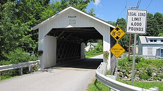
The Fuller Covered Bridge, also known as the Blackfalls Covered Bridge is a wooden covered bridge that crosses Black Falls Brook in Montgomery, Vermont on Fuller Bridge Road. It was listed on the National Register of Historic Places in 1974. The bridge is one of a concentrated regional collection built by brothers Sheldon & Savannah Jewett.

The Longley Covered Bridge, also known as the Harnois Covered Bridge, is a wooden covered bridge that crosses the Trout River in Montgomery, Vermont on Longley Bridge Road. Built in 1863, this Town lattice truss bridge is the oldest of a group of area bridges built by brothers Sheldon & Savannah Jewett. It was listed on the National Register of Historic Places in 1974. The bridge is closed to traffic, and has been bypassed by an adjacent temporary bridge.

The Morgan Covered Bridge, also known as the Upper Covered Bridge is a wooden covered bridge that crosses the North Branch Lamoille River in Belvidere, Vermont on Morgan Bridge Road. Built about 1887, it is one of two covered bridges in Belvidere, and one of five in a five-mile span that all cross the same river. It was listed on the National Register of Historic Places in 1974.

The Bowers Covered Bridge(akaBrownsville Bridge) is a historic covered bridge, carrying Bible Hill Road across Mill Brook in the Brownsville section of West Windsor, Vermont. Built in 1919, it has a laminated-arch deck covered by a post-and-beam superstructure, similar to Best's Covered Bridge, Windsor's other historic covered bridge. It was listed on the National Register of Historic Places in 1973. It was rebuilt after being swept off its foundation in 2011 by Hurricane Irene, but has been damaged by vehicle strikes several times since then, and is being considered for closure.

The Martin Covered Bridge is a wooden covered bridge spanning the Winooski River off United States Route 2 in southern Marshfield, Vermont. Built about 1890, it is the only surviving historic covered bridge in the town. It was listed on the National Register of Historic Places in 1974.

The Red Covered Bridge is a historic covered bridge, carrying Cole Hill Road across Sterling Brook in Morristown, Vermont. Built in 1896, it is the only surviving 19th-century covered bridge in the town, and one of the last to be built during the historic period of covered bridge construction in the state. It is of queen post truss design, and was listed on the National Register of Historic Places in 1974.
The River Road Covered Bridge was a historic covered bridge, carrying Veilleux Road across the Missisquoi River in Troy, Vermont. Built in 1910, the Town lattice truss was the only surviving covered bridge in Troy from the historic period of covered bridge construction when it burned on February 6, 2021. It also exhibited some distinctive variations in construction from more typical Town lattices. It was listed on the National Register of Historic Places in 1974.


