
Sakon Nakhon is a city in Thailand within the Isan region, and capital city of Sakon Nakhon Province as well as Mueang Sakon Nakhon District, with a population of approximately 76,000. Sakon Nakhon covers the whole tambon of That Choeng Chum and parts of tambons Ngio Don, Huai Yang, Dong Mafai, That Na Weng and Hang Hong. Sakon Nakhon is 651 km (405 mi) north-east of Bangkok by road.
The Poles of Cold are the places in the southern and northern hemispheres where the lowest air temperatures have been recorded.

Mandsaur District is a District of Madhya Pradesh state in central India. The town of Mandsaur is the administrative headquarters of the district and was controlled by mewar maharana as a last fort of mewar and protected by tomar rajput various period of time.
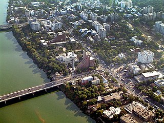
Ahmedabad is located on the banks of the River Sabarmati in the northern part of Gujarat and the western part of India. It is located at 23.03°N 72.58°E spanning an area of 205 km². The average elevation is 53 metres.

Jajpur is a town and a municipality in Jajpur district in the Indian state of Odisha. It was the capital of the Kesari dynasty, later supplanted by Cuttack. Now, it is the headquarter of Jajpur district.
Nagram is a town in Uttar Pradesh, India, in the Lucknow district. It is Located between the two roads from Lucknow city to Sultanpur and Raebareli. The distance between Lucknow and Nagram is 37 km. Raja Nal Pasi was the founder of Nagram. Its contemporary culture is the result of the amalgamation of the Hindu and Muslim rulers who ruled the town simultaneously and the credit for this goes to the secular and syncretic traditions of the Nawabs of Awadh, who took a keen interest in every walk of life and encouraged these traditions to attain a rare degree of sophistication. As a result, there are many historical holy religious sites in Nagram which are popular among all religions. Imambada Wajahat Hussain Rizvi is the Imambargah located in the center of Nagram, popularly known as Syedwada. Anjuman e Abbasiya is the oldest and existing anjuman of Nagram. Almas Ali Rizvi Grandson Of Late Zahid Ali Rizvi is an existing Zamindar.

Naraingarh is a city, municipal committee and assembly constituency in the Ambala district of the Indian state of Haryana, located on the border with the Indian state of Himachal Pradesh. Due to its geographical location, the Naraingarh plays an important role in local tourism, being located 52 km of Chandigarh, the state capital, 144 km of Shimla, and 230 km of New Delhi.

Purusottampur is a town and a notified area committee in Ganjam district in the Indian state of Odisha. Purushottmpur have lot of places to visit, one of them is Tara Tarani Temple which is very famous in Odisha.

Crispiano is a town in the province of Taranto in Apulia. The town has a population of 13749 inhabitants.

Pushpagiri, at 1,712 metres (5,617 ft), is the highest peak in Pushpagiri Wildlife Sanctuary in the Western Ghats of Karnataka. It is located in the Somwarpet Taluk, 20 kilometres (12 mi) from Somwarpet in the northern part of Kodagu district on the border between Dakshina Kannada and Kodagu district and hassan districts. It is 4th highest peak of Karnataka. The Sanskrit name of the mountain is Puṣpagiri while its Prakrit form is Puphagiri, which is mentioned in the Nagarjunakond Second Apsidal Temple inscription, although this may refer to a different mountain to the north of Cuddapah, in Andhra Pradesh.
Rambha is a town and a notified area council in Ganjam district in the Indian state of Odisha.
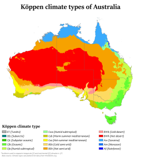
Australia's climate is governed mostly by its size and by the hot, sinking air of the subtropical high pressure belt. This moves north-west and north-east with the seasons. The climate is variable, with frequent droughts lasting several seasons, thought to be caused in part by the El Niño-Southern Oscillation. Australia has a wide variety of climates due to its large geographical size. The largest part of Australia is desert or semi-arid. Only the south-east and south-west corners have a temperate climate and moderately fertile soil. The northern part of the country has a tropical climate, varying between grasslands and desert. Australia holds many heat-related records: the continent has the hottest extended region year-round, the areas with the hottest summer climate, and the highest sunshine duration.

Hyderabad is located in central Telangana and is spread over an area of 2,500 km2. The city lies in the Deccan Plateau and rises to an average height of 536 m above the sea level. The city lies at 17.366° N latitude and 78.476° E longitude.
Janghai is a major bazaar and gram panchayat in the district of Jaunpur, in Uttar Pradesh. Janghai is located 226 km kilometres southeast of the state capital, Lucknow. Janghai is 24 kilometres from the tehsil of Handia and 20 kilometer from Machhalishahar.
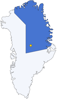
Summit Camp, also Summit Station, is a year-round staffed research station near the apex of the Greenland ice sheet. The station is located at 3,216 metres (10,551 ft) above sea level. The population of the station is typically five in wintertime, and has a maximum of 38 in the summer. The station is operated by the United States' National Science Foundation through the logistical support contractor Battelle Arctic Research Operations. A permit from the Danish Polar Center under the auspices of the Home Rule Government of Greenland is required to visit the station.

A humid subtropical climate is a zone of climate characterized by hot and humid summers, and cold to mild winters. These climates normally lie on the southeast side of all continents, generally between latitudes 25° and 40° and are located poleward from adjacent tropical climates. It is also known as warm temperate climate.

Amethi district is the 72nd district of the state of Uttar Pradesh in northern India. This district is part of Faizabad division. It covers an area of 3,070 km². Gauriganj is the administrative headquarters of the district.

Khichian is a village in the Faisalabad District, on Chiniot, Chak Jhumra road, Punjab, Pakistan. It is in Tehsil Chak Jhumra's Union Council # 04 and is 4 km away from the Faisalabad to Pindi Bhattian Motorway M4 Deputy Wala Interchange. Its Latitude is 31° 36' 27.83"N, and Longitude is 73° 07' 31.35"E. The people of Khichian use the M3 to commute, as it is 140 kilometers away from Lahore and 24 kilometers away from Faisalabad. Nearby towns are Faisalabad, Chak Jhumra, Chiniot, Pindi Bhattian. By road, Khichian is connected to Faisalabad, Barnala, Chak Jhumra, and Chiniot. The most famous things in Khichian are Headquarters of Union Council # 04.

The city of Thrissur is situated in the southwest of the South Indian state of Kerala of Thrissur district. A landlocked city, Thrissur is located on a hillock which is surrounded by Thrissur Kole Wetlands. Thrissur district borders with Palakkad district in east, Malappuram district in the north, Ernakulam district in the South and Arabian Sea in the west.
Charkha is one of 11 villages in Dhari Taluka and one of 616 in the Amreli district of the Saurashtra peninsula in the Indian state of Gujarat.[1]

